

Workbench Release History
Workbench Release History
Workbench Release History

Create successful ePaper yourself
Turn your PDF publications into a flip-book with our unique Google optimized e-Paper software.
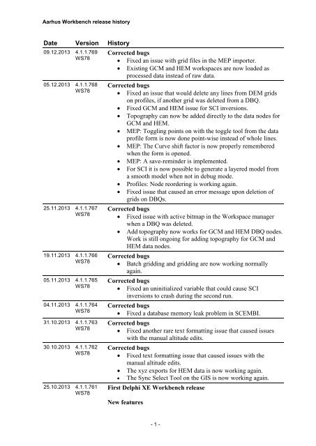
Aarhus <strong>Workbench</strong> release history<br />
Date Version <strong>History</strong><br />
09.12.2013 4.1.1.769<br />
WS78<br />
05.12.2013 4.1.1.768<br />
WS78<br />
25.11.2013 4.1.1.767<br />
WS78<br />
19.11.2013 4.1.1.766<br />
WS78<br />
05.11.2013 4.1.1.765<br />
WS78<br />
04.11.2013 4.1.1.764<br />
WS78<br />
31.10.2013 4.1.1.763<br />
WS78<br />
30.10.2013 4.1.1.762<br />
WS78<br />
25.10.2013 4.1.1.761<br />
WS78<br />
Corrected bugs<br />
Fixed an issue with grid files in the MEP importer.<br />
Existing GCM and HEM workspaces are now loaded as<br />
processed data instead of raw data.<br />
Corrected bugs<br />
Fixed an issue that would delete any lines from DEM grids<br />
on profiles, if another grid was deleted from a DBQ.<br />
Fixed GCM and HEM issue for SCI inversions.<br />
Topography can now be added directly to the data nodes for<br />
GCM and HEM.<br />
MEP: Toggling points on with the toggle tool from the data<br />
profile form is now done point-wise instead of whole lines.<br />
MEP: The Curve shift factor is now properly remembered<br />
when the form is opened.<br />
MEP: A save-reminder is implemented.<br />
For SCI it is now possible to generate a layered model from<br />
a smooth model when not in debug mode.<br />
Profiles: Node reordering is working again.<br />
Fixed issue that caused an error message upon deletion of<br />
grids on DBQs.<br />
Corrected bugs<br />
Fixed issue with active bitmap in the Workspace manager<br />
when a DBQ was deleted.<br />
Add topography now works for GCM and HEM DBQ nodes.<br />
Work is still ongoing for adding topography for GCM and<br />
HEM data nodes.<br />
Corrected bugs<br />
Batch gridding and gridding are now working normally<br />
again.<br />
Corrected bugs<br />
Fixed an uninitialized variable that could cause SCI<br />
inversions to crash during the second run.<br />
Corrected bugs<br />
Fixed a database memory leak problem in SCEMBI.<br />
Corrected bugs<br />
Fixed another rare text formatting issue that caused issues<br />
with the manual altitude edits.<br />
Corrected bugs<br />
Fixed text formatting issue that caused issues with the<br />
manual altitude edits.<br />
The xyz exports for HEM data is now working again.<br />
The Sync Select Tool on the GIS is now working again.<br />
First Delphi XE <strong>Workbench</strong> release<br />
New features<br />
- 1 -
Aarhus <strong>Workbench</strong> release history<br />
<br />
New significantly improved GUI for the ERT data<br />
processing system.<br />
04.09.2013 4.1.1.760<br />
WS77<br />
14.08.2013 4.1.1.759<br />
WS76<br />
11.07.2013 4.1.1.758<br />
WS76<br />
Corrected bugs<br />
A problem with the sounding window 'jumping' has been<br />
solved<br />
Two range checks for the SSV model grid have been added:<br />
1) Node distance must be larger than 200 m. This prevents<br />
the user from setting up non-meaningful SSV jobs.<br />
2) Total number of node points (X-nodes times Y-nodes)<br />
must be < 10000. This prevents the user from setting up very<br />
big SSV jobs that will probably result in out-of-memory<br />
problems. Note: < 10000 nodes can still cause out-ofmemory<br />
problems depending on the amount of memory in<br />
the current PC.<br />
Fixed a rare issue that prevented the edit form from opening<br />
as it could end up with a logarithmic axis with negative<br />
values<br />
Fixed an issue that under certain circumstances may prevent<br />
the creation of the VIS node altdif<br />
Loading an .inv file while creating a new SCI node is now<br />
working<br />
Geological Surfaces: Interpolated lines are now displayed as<br />
points, thereby showing “holes” in the interpolated surface.<br />
Fixed an issue causing error when importing TEM40 data<br />
into an empty Gerda database.<br />
Corrected bugs<br />
Updated version of GStat, resolving stability issues in the<br />
batch gridding module<br />
Resolved issue with inversion of MegaTEM data<br />
New features<br />
New Visualization Themes implemented:<br />
STD for the Conductivity Layer<br />
a-priori STD for the Layers: Resistivity, Conductivity,<br />
Thickness and Depth<br />
Difference between input data and inverted data<br />
Max. relative data residual per data point<br />
Gate no. for max. relative data residual per data point<br />
Corrected bugs<br />
Issue that caused translation function to become 99 in all its<br />
nodes was solved.<br />
Fixed issue causing errors when uploading an open<br />
workspace.<br />
Corrected bugs<br />
Fixed issue that prevented making manual altitude<br />
corrections<br />
Removed chart tools with obsolete functionality<br />
Fixed issue with deletion of profile nodes<br />
- 2 -
Aarhus <strong>Workbench</strong> release history<br />
03.07.2013 4.1.1.757<br />
WS76<br />
01.07.2013 4.1.1.756<br />
WS76<br />
18.06.2013 4.1.1.755<br />
WS76<br />
13.06.2013 4.1.1.754<br />
WS75<br />
<br />
<br />
Changed the layout of the multi delete function<br />
Batch Gridding nodes are no longer added to the GIS<br />
manager.<br />
Corrected bugs<br />
Fixed issue with long database paths when creating few<br />
layered models for SCI<br />
New features in geo. surfaces<br />
New right click menu on the geo. surface list on the profile<br />
form. Functionality from former buttons has been moved to<br />
this menu.<br />
o 'Visible Lines...' --> Points and grids from other<br />
profiles can be shown on a profile.<br />
o 'Line Display Settings...' -> Format of lines can be<br />
set.<br />
o 'Update Current/All grids' -> Updates grids with<br />
existing settings.<br />
o 'Update GIS Points' -> Updates the GIS points. Is<br />
shown by ticking on the geo. surface node in the '<br />
'Workspace Manager'<br />
o 'Update Color' -> Updates the geo. surface color.<br />
This can also be done by clicking on the colored<br />
square.<br />
o 'Delete' -> Deletes the geo. surface.<br />
Uncertainties of already drawn points can be changed by<br />
selecting the point and selecting a new Uncertainty number,<br />
then press the button 'Update Uncertainties'<br />
Corrected bugs<br />
Fixed issue with the GIS when creating new workbench<br />
projects with certain EPSG coordinates.<br />
Fixed issue with deletion of files when using the "Create<br />
Final Report Page(s)" functionality.<br />
Fixed issue with giving new profiles names of previous<br />
deleted ones.<br />
Survey info database selection is now also available for<br />
MEP export.<br />
Font and color can now be changed in Edit Label.<br />
When Batch Gridding the nodes are added to the GIS<br />
manager.<br />
Check on Geometry file during import is now only done on<br />
enabled gates.<br />
Corrected bugs<br />
The SKY icon name has been changed to AEM<br />
Corrected bugs<br />
Fixed issue with the start up location of the SCI wizard form.<br />
Now the UTM coordinates of the mouse position is written<br />
on the status bar on the profile plot. Tick the status bar<br />
visible on the top of the profile plot to use the feature.<br />
Fixed issue that occurred when uploading workspaces with<br />
- 3 -
Aarhus <strong>Workbench</strong> release history<br />
the “Upload Workspace…” functionality.<br />
07.06.2013 4.1.1.753<br />
WS74<br />
24.05.2013 4.1.1.752<br />
WS74<br />
15.05.2013 4.1.1.751<br />
WS74<br />
Corrected bugs<br />
Fixed an issue that prevented setting the PACES processing<br />
in-use flags from the data profile form in the inversion<br />
explorer properly.<br />
Changed the layout of the sounding curve plot form for<br />
PACES data<br />
A check was added to ensure that all gates have a center<br />
times above zero also after being time shifted.<br />
The "New Combined Theme..." option has been removed<br />
from the right click menu on map layer nodes.<br />
Fixed issue with point themes reverting to a single colour<br />
when changing the labels.<br />
Re-enabled functionality to enable and disable points on<br />
DBQ and borehole maps.<br />
It is now possible to run a SSV job with grids also when the<br />
workspace name include spaces.<br />
Corrected bugs<br />
Fixed a synchronization error in toggling PACES data in-use<br />
flags from the inversion visualization system<br />
In 'Plot Data' is added a message during click on<br />
'constant/factor, asking for selection of item if no item is<br />
selected<br />
In 'Plot Data' is the maximum value for 'buffer size in<br />
meters' under 'set buffer pos...' changed to 5000<br />
The deactive 'Plot Data' now closes the 'Plot Data'-window<br />
for Paces data as well<br />
Fixed issue with units in the sounding plot form for SkyTEM<br />
data<br />
Changed the layout of the sounding plot form for TEMPEST<br />
data<br />
Fixed issue with how the shape of the DC explorer is saved<br />
In inversion settings for TEMPEST data there are new<br />
default values for the wing settings<br />
The shortcut in Model Explorer to Model Explorer Settings<br />
has been changed from Alt + a to Alt + f<br />
Corrected bugs<br />
Fixed an SCI inversion indexing error introduced in version<br />
4.1.1.745. The issue is non-critical as any inversion affected<br />
by the problem is immediately identifiable when inspecting<br />
the result<br />
Fixed a bug regarding importing VTEM data for two<br />
columns<br />
A bug preventing running SSV jobs has been fixed<br />
Fixed issue with the GIS info tool<br />
Now there is a check for identical label names when<br />
importing XYZ files<br />
- 4 -
Aarhus <strong>Workbench</strong> release history<br />
07.05.2013 4.1.1.750<br />
WS74<br />
11.04.2013 4.1.1.749<br />
WS74<br />
10.04.2013 4.1.1.748<br />
WS74<br />
Revision of the SSV module<br />
The performance has been significantly improved<br />
Bigger jobs can be handled<br />
Blinding the geophysical models with DOI has been<br />
implemented<br />
The linking to the GEUS bore report web page has been<br />
fixed<br />
SSV jobs can only be run on 64 bit windows platform, due<br />
to a new GStat version<br />
The con file is now version 7<br />
The model parameter analysis can be turned of in the con<br />
file. This reduces the calculation time significantly<br />
Min/max value for Upper and Lower model parameter in<br />
con file has been adjusted<br />
New features<br />
In the TEM importer the column number are now shown in<br />
the alc file editor<br />
Now the ALC file editor for airborne TEM data can set<br />
gate_ch01_begin and gate_ch01_end<br />
If the A-priori STD is set to 0 for airborne data the altitude is<br />
kept fixed during the inversion<br />
It is now possible do delete databases from the <strong>Workbench</strong><br />
Corrected bugs<br />
Now it possible to use colorscales from all 'VIS' nodes in the<br />
'Create Final Report Pages'<br />
Now map symbols for boreholes and models are shown<br />
correctly when adding conductivity a-priori on SCI<br />
Now 'New SCI' can only be called from relevant nodes<br />
An issue in the Tempest importer regarding time stamps has<br />
been fixed<br />
Fixed issue with altitude normalization that occurred after<br />
switching off debug mode<br />
In the general model importer, the X and Y coordinates are<br />
now required<br />
Now the previous selected database is remembered in the<br />
DBQ wizard<br />
Fixed issue in AarhusInv with memory leak for TEMPEST<br />
data<br />
Corrected bugs<br />
Export xyz files from an SCI node is now working properly<br />
Fixed issue with AarhusInv running on Windows XP<br />
When creating a new GERDA or Borehole database, the<br />
default location in the workspace folder is now always used.<br />
After adding a new GERDA database the importer is<br />
automatically shown.<br />
New features<br />
Now skyTEM inversions can be added to profiles. Use 'Add<br />
Data Query(DBQ) from a profile node<br />
- 5 -
Aarhus <strong>Workbench</strong> release history<br />
04.04.2013 4.1.1.747<br />
WS73<br />
03.04.2013 4.1.1.746<br />
WS73<br />
14.03.2013 4.1.1.745<br />
WS73<br />
05.03.2013 4.1.1.744<br />
WS73<br />
01.03.2013 4.1.1.743<br />
WS72<br />
Corrected bugs<br />
Fixed a stability issue writing PACES forward response files<br />
from AarhusInv<br />
Now copying profile layers is working again<br />
The unit for average sounding plots has been corrected<br />
Corrected bugs<br />
Fixes issue causing problems when viewing profiles<br />
Corrected bugs<br />
Fixes to em1dinv-configuration files for Tempest data<br />
Smoother performance when adding topography grids to<br />
data<br />
Enabled copying of the GIS map to the clipboard<br />
Fixed issue with the edit display functionality<br />
Due to better disk-based GIS-performance, memory catching<br />
is now disabled by default<br />
Fixed coordinate problem with the DBQuery Wizard<br />
Fixed issue with move up/down on profile nodes<br />
A DOI related bug in the general model importer has been<br />
fixed<br />
Updated version of AarhusInv supporting the Intel “Penryn”<br />
processor family<br />
Corrected bugs<br />
The point size in the processing system are not back to<br />
normal<br />
Fixed issue with error message when closing workspace<br />
The properties on LCI inversion nodes now works again<br />
Issue creating new processings when name of SkyTEM node<br />
was not unique<br />
Issue when closing WS with several active PACES<br />
processings<br />
A bug preventing running X-data inversing with pitch has<br />
been fixed<br />
Fixed issue when using the edit display functionality for<br />
point themes<br />
Now boreholes visible status reflects the master, from where<br />
the profile layers are copied from, i.e. if their layer is visible<br />
on the master, it is visible on the 'copied to' profile as well.<br />
Fixed issue about uploading of databases to the FTP<br />
New features<br />
Beta release of Geosurface module. Official release to be<br />
announced soon.<br />
Corrected bugs<br />
Added performance information to the log file of AarhusInv<br />
and resolved a special case problem with the approximate<br />
TEM response<br />
Corrected bugs<br />
Fixed save issues on processed PACES data<br />
- 6 -
Aarhus <strong>Workbench</strong> release history<br />
15.02.2013 4.1.1.742<br />
WS72<br />
08.02.2013 4.1.1.741<br />
WS72<br />
31.01.2013 4.1.1.740<br />
WS72<br />
21.01.2013 4.1.1.739<br />
WS72<br />
02.01.2013 4.1.1.738<br />
WS72<br />
17.12.2012 4.1.1.737<br />
WS72<br />
12.12.2012 4.1.1.736<br />
WS72<br />
11.12.2012 4.1.1.735<br />
WS72<br />
<br />
<br />
All bitmaps produced with batchgridding were of a single<br />
color<br />
Fixed an error that caused an exception when drawing new<br />
profiles<br />
Corrected bugs<br />
Fixed issue in the SKYTEM processing system<br />
Fixed issue related to the update of the inversion kernel<br />
New features<br />
Updated version of the inversion kernel (AarhusInv version<br />
6.0):<br />
- Memory consumption lowered significantly over<br />
previous version.<br />
- New approximate TEM response supporting X-<br />
component data.<br />
- Support for modeling of Gaussian filters found on the<br />
latest SkyTEM instrument.<br />
- Elevation based resistivity regularization to better<br />
accommodate effects of topography.<br />
Corrected bugs<br />
Fixed user reported issues with the optimized GIS<br />
component<br />
Fixed a number of issues as well as optimized the PACES<br />
pre-processor.<br />
Corrected bugs<br />
Fixed issue related to profile drawing in the GIS<br />
Corrected bugs<br />
Issues related to moving nodes up/down in the workspace<br />
tree.<br />
New feature<br />
Improvements to the GIS-performance. The redrawing of<br />
maps is now faster.<br />
The ‘auto scale’ option for inversions now provides much<br />
better starting models for LCI and SCI.<br />
Corrected bugs<br />
Fixed a database related bug in SSV 'auto clay'<br />
Fixed issue with bad data type in batch gridding process<br />
Corrected bugs<br />
Fixed issue with too big STD values on raw SKYTEM data<br />
Corrected bugs<br />
Fixed critical pathing issue that occurred spontaneously<br />
when activating SkyTEM processings<br />
Corrected bugs<br />
Implemented load/save of dates of .GDT files in the PACES<br />
pre-processing program.<br />
In the SSV auto clay calculation a change has been made<br />
when calculating between two grids. If the value from the<br />
- 7 -
Aarhus <strong>Workbench</strong> release history<br />
21.11.2012 4.1.1.734<br />
WS72<br />
16.11.2012 4.1.1.733<br />
WS72<br />
15.11.2012 4.1.1.732<br />
WS72<br />
10.10.2012 4.1.1.731<br />
WS71<br />
<br />
<br />
grid at the borehole position is above the<br />
elevation/topography from the boreholedatabase the<br />
borehole/interval is set 'not in use', and an autocomment is<br />
added. This makes the SSV job run.<br />
Fixed issue during import of data with multiple channels<br />
(TEMPEST, SKYTEM XYZ)<br />
Fixed issue with inversion of old PACES data downloaded<br />
from GERDA.<br />
Corrected bugs<br />
Fixed bug during a processing node action<br />
Fixed issue with the GCM importer in the ppm format<br />
Corrected bugs<br />
Fixed issue with the SCI<br />
Corrected bugs<br />
Fixed issue with the fence gridding in GIS<br />
Fixed bad check for dummy values and thicknesses in the<br />
general model importer<br />
Fixed issue with section-selection in inversion explorer<br />
Fixed a number of issues in the CVS-processing module<br />
Removed limit of 8 characters on VIS node names<br />
Fixed bug on the update of the color scale in the color scale<br />
wizard<br />
Fixed random bug making the export of an SCI node,<br />
correctly inverted, impossible.<br />
In SkyProcessing when plotting GPS data, GPS Altitude has<br />
been changed to GPS Elevation (WGS84) and GPS<br />
Elevation has been changed to GPS Altitude.<br />
New feature<br />
Keyboard shortcut for toggling map-centering on/off in<br />
SkyTEM processing (Ctrl + C)<br />
It is now possible to change the order of the nodes in the<br />
Workspace Manager tree.<br />
Use the right click menu or the short cuts Ctrl + and Ctrl –<br />
It is now possible to know the database name of a node by<br />
passing the mouse over this node.<br />
The copy to clipboard functionality has been enabled again.<br />
Support for different numbers of layers in the general model<br />
importer (models from xyz-files).<br />
To allow for colorscales to handle very small units, a<br />
‘scaling factor’ has been added to the preferences form. If<br />
used, values will be multiplied by this factor before a<br />
colorscale is applied.<br />
GIS now supports SID raster layers<br />
Corrected bugs<br />
Fixed issue causing monochrome display of VIS-nodes<br />
when 'In-memory'-caching was enabled for the GIS<br />
Log option is now available for Histogram works out in the<br />
- 8 -
Aarhus <strong>Workbench</strong> release history<br />
<br />
<br />
<br />
<br />
<br />
<br />
<br />
Colorscale wizard<br />
Fixed bug with Res2DInvViewer and the wrong library files<br />
Bad coordinate settings from the CVES importer have been<br />
fixed<br />
Fixed bug on Auto Clay Thickness button, in the borehole<br />
editor<br />
Fixed issue related to the display of the wrong/no symbol on<br />
the map from processing the system<br />
Fixed small issue related to the manual edit/entry of<br />
boreholes<br />
Fixed bug with the project name during an export model<br />
Fixed bug with lines number on SkyTEM importer<br />
New feature<br />
The line numbers for PACES data are now available in the<br />
inversion system (LCI and SCI)<br />
Performance improvement in the VTEM, AeroTEM,<br />
Tempest and MegaTEM importers<br />
The log report of the import is now displayed in the wizard<br />
importer when data have been imported<br />
During export of models, the msc file is not written out<br />
anymore. DOI values are now available in the inv.xyz file<br />
18.09.2012 4.1.1.730<br />
WS71<br />
14.09.2012 4.1.1.729<br />
WS71<br />
03.09.2012 4.1.1.728<br />
WS71<br />
Corrected bugs<br />
Fixed bug on unavailable actions in the main menus<br />
Fixed issue with the 'Display Properties'-button in the<br />
SkyTEM processing system.<br />
Corrected bugs<br />
Option “altitude normalization” (beta version) is now only<br />
available in debug mode.<br />
The label 'field' for a layer can now be set via right-click in<br />
the Layer Manager in the GIS.<br />
Fixed bug on the topography visualization: values are now<br />
only elevation and not the difference between elevation and<br />
inverted altitude anymore.<br />
Small changes to VIS-nodes in the Workspace Manager.<br />
New feature<br />
Sync. from the GIS to inversion model position explorer is<br />
now in place<br />
Labelling of profiles is now possible using the GIS.<br />
Multiple deletes functionality is now available from the right<br />
click menu of the map level. All selected nodes will be<br />
deleted at the same time<br />
Corrected bugs<br />
Line files now support the line type, under format<br />
LineNumber.LineType.<br />
Values for line type are from 1 to 9.<br />
Line file without this line type are still supported. A default<br />
- 9 -
Aarhus <strong>Workbench</strong> release history<br />
30.08.2012 4.1.1.727<br />
WS71<br />
28.08.2012 4.1.1.726<br />
WS71<br />
27.08.2012 4.1.1.725<br />
WS71<br />
16.07.2012 4.1.1.724<br />
WS71<br />
05.07.2012 4.1.1.723<br />
WS71<br />
<br />
<br />
value (1) is then used.<br />
It is now possible to edit the plot display during a theme<br />
creation.<br />
Fixed issue with SkyTEM sync. from the GIS..<br />
Corrected bugs<br />
Fixed bug with LCI inversion and "Force continuous<br />
models" option : mod files are completely rewritten without<br />
issue.<br />
Fixed issue triggered when adding topography to GCM<br />
nodes.<br />
Fixed the creation of themes and the Windows registry<br />
database.<br />
Corrected bugs<br />
Fixed bug making the SCI node creation impossible<br />
Fixed bug on reporting bugs form Cancel button<br />
Fixed bug on unavailable actions in the main menus<br />
Fixed bug during altitude processing with unavailable<br />
devices<br />
Fixed small issue related to the map indicator from the<br />
profile window<br />
Corrected bugs<br />
Fixed registry bug when setting up an inversion (LCI and<br />
SCI) by adding safe checks in the code.<br />
Numerous dataset specific issues resolved in the PACES<br />
processing module<br />
New feature<br />
Support for Jupiter borehole databases in Firebird format:<br />
- It is now possible to use Firebird borehole databases<br />
- Implemented color scale editor for borehole lithology.<br />
Right click on a borehole database and select "Change<br />
Colors..."<br />
New bug reporting system. The new system facilitates<br />
generating a more comprehensive error report along with<br />
automatic Workspace upload to the HGG support server<br />
Corrected bugs<br />
Minor issue with em1dinv configuration file fixed.<br />
The bug with the synthetic files, during the export of models<br />
into files has been fixed and the synthetic file contains now<br />
the correct values for columns REAL and IMAG.<br />
Fixed minor bug in GIS display of processed PACES data.<br />
Corrected bugs<br />
The wave form definition (for wave form type 2) is now<br />
correctly written (when exporting TEM files for instance)<br />
New feature<br />
A warning message is now displayed before launching an<br />
- 10 -
Aarhus <strong>Workbench</strong> release history<br />
28.06.2012 4.0.1.722<br />
WS71<br />
22.06.2012 4.0.1.721<br />
WS71<br />
06.06.2012 4.0.1.720<br />
WS71<br />
31.05.2012 4.0.1.719<br />
WS71<br />
<br />
inversion if the <strong>Workbench</strong> uses a Trial license file.<br />
PACES processing now available.<br />
Corrected bugs<br />
Export Data : for MEP data, the Datasets Selector Form is<br />
not displayed anymore since all datasets must be selected to<br />
input survey information. These datasets are automatically<br />
selected.<br />
For other data types, this form is still displayed and user can<br />
select any dataset he wants.<br />
A fix has been made on the export models functionality<br />
(with creation of files). All frequency columns are now<br />
correctly written out.<br />
New feature<br />
The batch gridding function is now available for external<br />
files.<br />
Corrected bugs<br />
A mode file reader compatibility problem that could cause<br />
an exception when trying to display profiles in version<br />
4.0.1.720 has been fixed.<br />
Issues regarding survey info on CVS data resolved. Client<br />
information can now be set independently and an issue in<br />
adding information on inversion software has been fixed.<br />
Models Edition for 2d inversions : the ident name has been<br />
fixed and now uses the datatype for all data but TEM. For<br />
TEM data, the datasubtype is used.<br />
The Note field, stored in the MOEDITION table, can now<br />
accept 1024 characters, without any other restriction.<br />
When exporting models, the table MODSW is now correctly<br />
filled up.<br />
When exporting data, the inversion software fields, in the<br />
survey information form, are not available anymore because<br />
they are useless.<br />
The text in the upgrade dialog has been changed to a correct<br />
description of the upgrade process<br />
Creation of VIS nodes has been sped up.<br />
New feature<br />
It is now possible to invert using a shift factor for TEM data<br />
Corrected bugs<br />
Error in configuration file for em1dinv has been fixed.<br />
Corrected bugs<br />
GIS: Zooming on the map using the mouse wheel is now<br />
slower, and the zoom behavior for the left/right mouse<br />
buttons has been switched.<br />
Import of 2d CVS models has been improved and the<br />
MOEDITION datasubtype related bug has been fixed.<br />
The upload to GERDA issue has been fixed.<br />
- 11 -
Aarhus <strong>Workbench</strong> release history<br />
<br />
<br />
<br />
The export behavior has been checked and when exporting<br />
2d models, only one unique edition is created, linking all the<br />
selected models together.<br />
All colorscale related problems on a DEM node have been<br />
fixed. It is now possible to see the colorscale on the map for<br />
bitmaps created from DEM node and all error/warning<br />
messages are not displayed anymore.<br />
The bug about opening the wrong workspace, on the<br />
Welcome Screen, has been fixed.<br />
Now, the opened workspace is really the selected one.<br />
Problems with lck file that avoid opening a workspace, even<br />
if this one was not used by anybody, have been fixed.<br />
25.05.2012 4.0.1.718<br />
WS71<br />
21.05.2012 4.0.1.717<br />
WS71<br />
11.05.2012 4.0.1.716<br />
WS 71<br />
09.05.2012 4.0.1.715<br />
WS 71<br />
New feature<br />
A new option is available for the Height System in the<br />
dataset settings : EGM-96 World.<br />
This is used when importing data.<br />
Corrected bugs<br />
The new field refmodel, used to export tem models, is now<br />
available on the SCI export models form.<br />
This field is only enabled for SKYTEM, AEROTEM,<br />
VTEM, MEGATEM and Tempest data.<br />
New feature<br />
A new installer for Aarhus <strong>Workbench</strong> is now available on<br />
our web site.<br />
(http://www.hgg.geo.au.dk/HGGsoftware/workbench/Workb<br />
ench_full_4-0-0-700.exe)<br />
Corrected bugs<br />
Some errors in the display of "Plot Settings" parameters<br />
have been fixed.<br />
The coil response setting is now only available for SkyTEM<br />
data.<br />
So some bad checks are avoided when data is not SkyTEM<br />
Some settings issues on the first page of the SCI wizard have<br />
been fixed.<br />
Corrected bugs<br />
Fix on the show inversion results forms. The inverted<br />
altitude and CR factors are now displayed again.<br />
Corrected bugs<br />
A bug about creating bitmaps has been fixed. For some color<br />
scales, it was not possible to save the levels into the<br />
workspace database because of identical values.<br />
Registry issue with Plot Settings in the Models Section is<br />
now fixed. This issue could make the plot of some values<br />
impossible because of a bad factor value.<br />
Fixed several MODEL.IDENT string formatting issues,<br />
mostly related to data type specific issues.<br />
The TEM Data Import functionality is now working<br />
- 12 -
Aarhus <strong>Workbench</strong> release history<br />
25.04.2012 4.0.1.713<br />
WS 71<br />
20.04.2012 4.0.1.712<br />
WS 71<br />
correctly.<br />
New feature<br />
The resistivity in the layer intersected by the DOI (upper or<br />
lower) can now be extracted in 'Visualize data or Inversions'.<br />
The Theme is found on the DOI tab.<br />
Corrected bugs<br />
Added support for millisecond time stamp precision in SPS<br />
files<br />
Fix in the export data and models functionality: no more<br />
issue when the node names have capital letters<br />
New Features<br />
Now the DOI values are exported in the inv-files.<br />
A number of new processing settings have been added for<br />
airborne TEM data. This is<br />
o A separate set of trapeze filter width can be specified<br />
and applied to data above a given flight height.<br />
o A new slope filter for average data work from a<br />
given time and towards EARLY times. This is to<br />
delete early time data which has a non physical<br />
behavior. The filter is useful for e.g. VTEM data.<br />
Corrected bugs<br />
Updated 32 bit version of em1dinv which resolves certain<br />
SCI stability issues for large problems. However, we still<br />
highly recommend using the 64 bit version whenever<br />
possible.<br />
A few bugs have been fixed in the upgrade procedure for the<br />
map, and the procedure has been optimized to run a lot<br />
faster.<br />
A memory leek when creating themes has been eliminated.<br />
Always close theme form before gridding, especially if the<br />
workspace is large!<br />
Small issues with transparency and bitmaps have been<br />
resolved.<br />
Resolved model edition related GERDA reporting issue. The<br />
GERDA error "ORA-00001: unique constraint<br />
(GERDA_OWNER.XAKGER$MODELEDITION_IDENT)<br />
" is resolved by performing a new export with this release of<br />
the Aarhus <strong>Workbench</strong><br />
Improvement of inversion log stability<br />
Now the DOI lines on DBQ layers on profiles are initialized<br />
correct for new users<br />
The profile unit is now set correctly for new users<br />
The inversion is now by standard performed in dbdt as it<br />
allows data to be negative at early times correcting for coil<br />
response. A check has been added in the filtering procedures<br />
so that data are now always checked for negative signs<br />
according to the setting for the average sign filter.<br />
- 13 -
Aarhus <strong>Workbench</strong> release history<br />
09.03.2012 4.0.1.711<br />
WS 71<br />
4.0.1.710<br />
WS 71<br />
01.03.2012 4.0.1.709<br />
WS 71<br />
01.03.2012 4.0.1.708<br />
WS 71<br />
29.02.2012 4.0.1.707<br />
WS 71<br />
<br />
<br />
<br />
<br />
<br />
Improvement in error messages during a SkyTEM import.<br />
Problem with some PACES and MEP 1D inversions fixed<br />
("Field value required" error)<br />
New format in the MOEDITION.IDENT field: the model<br />
reference is now added with following values:<br />
refmodeldk01, refmodeldk02, refmodelnone.<br />
This field can be selected for all TEM data type and is<br />
"refmodelnone" for all the other ones. The new format of the<br />
IDENT field is: dk.mim.ode.grundvand-faaborgskytem.skytem2.refmodeldk02.1dsci.smooth.noprior.19layer<br />
s_primary<br />
project ident.datasubtype.model reference. model<br />
subtype.parameterisation.prior.edition name<br />
Fixed a bug in the CVES importer, so finer topography grids<br />
can be used.<br />
A problem when using factor blinding of mean resistivity<br />
maps in connection with one layer models has been fixed.<br />
New Features<br />
The display, e.g. the color scale, can now be changed for a<br />
bitmap.<br />
Corrected bugs<br />
In ‘Show inverions result’, the Bar & GIS settings form now<br />
remembers the last used color scale.<br />
Setting the point size for VIS nodes now works properly.<br />
The visual settings (colors, line styles, etc.) for the drawing<br />
layer are now remembered if the workspace is closed and<br />
reopened.<br />
The help system for the <strong>Workbench</strong> now works for<br />
Windows 7/Vista systems.<br />
The edition management has been improved for the SCI<br />
export and some inconsistency between values and edition<br />
ident name have been fixed. ModelSubType, prio fields are<br />
now correct.<br />
The Edit color scale for 3D grids is now possible.<br />
Corrected bugs<br />
A bug regarding exporting SkyTEM models has been fixed.<br />
Now it possible to export a theme shape format.<br />
Corrected bugs<br />
A bug when creating new profiles has been fixed.<br />
Corrected bugs<br />
A new license file is included.<br />
New features<br />
<br />
The colour, style and thickness of profile lines on the map<br />
can now be edited. Click on the profile node in the<br />
workspace manager.<br />
Corrected bugs<br />
The map position indicator for Profiles etc. will no longer<br />
- 14 -
Aarhus <strong>Workbench</strong> release history<br />
27.02.2012 4.0.1.706<br />
WS 70<br />
<br />
<br />
<br />
<br />
<br />
freeze if a new layer is added to the map<br />
A patch has been made in order to allow importing old<br />
skytem system data: the number of shots can be read<br />
correctly<br />
It is now possible to use any value as dummy value in the<br />
General Model Importer, and a different one for each file<br />
(models, data and response).<br />
The corresponding imported value will be NaN in the<br />
database.<br />
It is now possible to use the field "Import Every" on the first<br />
page of the General Model Importer in order to skip some<br />
lines from the file to import. If e.g. 3 is selected, then only 1<br />
out of 3 lines are imported.<br />
Fixed an error in the SkyTEM data importer related to<br />
changes in the skb file header format. The issue was<br />
introduced in version 4.0.1.706<br />
Fixed an error in the SCI module that caused depth STDs for<br />
models lying on cell borders to become too large for the<br />
result model set. This bug was introduced in 3.3.14.365.<br />
New features<br />
The ‘Select SkyTEM’ tool has been added to the Map<br />
window toolbox. It is located in the ‘<strong>Workbench</strong> Functions’<br />
group.<br />
When creating a profile the unit can now be set to resistivity<br />
or conductivity. Then all DBQ's and 3D grids added to the<br />
profile will be in the selected unit.<br />
Now the Workspace database version and the <strong>Workbench</strong><br />
version is stored for every node created. This information<br />
can be seen by double clicking at the panel at the bottom of<br />
the Workspace manager.<br />
Now the DOI as a line can be added together with the DBQ<br />
as bars on profiles. Both the DOI upper and lower can be<br />
added and the line display can be chosen.<br />
Corrected bugs<br />
The 2d inversion can now manage the edition system, so<br />
MODEL and MOEDITION tables are updated after the<br />
import in Res2DinvViewer program.<br />
Check added during the SCI creation : it is not possible<br />
anymore to select the coil response inversion for only a part<br />
of data sources.<br />
It is now again possible to change the colorscale on profiles<br />
Fixed a minor log color scale display issue in the color scale<br />
selector.<br />
Restoring default inversion setting filenames from registry<br />
now works correctly.<br />
Color scale ticks for very small values on log color scales are<br />
now displayed correctly.<br />
The colorscale displayed in the Model Section Settings form<br />
is now restored from the registry (if the used colorscale file<br />
- 15 -
Aarhus <strong>Workbench</strong> release history<br />
03.02.2012 4.0.1.705<br />
WS 69<br />
01.02.2012 4.0.1.704<br />
WS 69<br />
<br />
<br />
<br />
<br />
does not exist anymore).<br />
‘Zoom to layer’ button on Map has been moved to the popup<br />
(right click) menu of the Map Layer Manager.<br />
Scale bar on map is now resizable and has been moved.<br />
The "add survey info" bugs have been fixed : it is now<br />
possible to select several datasets, to select any switch box<br />
(for MEP data) and to add the information correctly to the<br />
database. The edition entries will be updated without issue.<br />
The Skytem imported has been fixed and does not import<br />
SKYNAVVAL values from other data types (VTEM,<br />
AEROTEM, Tempest...) into the GERDA database.<br />
Corrected bugs<br />
In order to import models qith the Groundbased TEM models<br />
(Danish users only) importer (2968):<br />
o Choose one or several datasets on the left part of the<br />
form with the button "..."<br />
o Choose one or several emo files on the right part with<br />
the other button "..."<br />
o Select the dataset and the emo file you want and<br />
then, the Import button will be available.<br />
o Before importing, you also need to set the<br />
Preferences and the Edition settings with the<br />
corresponding buttons<br />
The options 'White as transparent' and 'Translucency' does<br />
not work when creating bitmaps from grids, or adding<br />
already existing bitmap layers to the map. Creating a bitmap<br />
from a grid will also result in the warning 'File not found:<br />
xxx.bmp', although the bitmap is created succesfully. The<br />
issue has been fixed, and the options should now work as<br />
before (2966)<br />
GIS now flushes the layer memory cache whenever the<br />
maximum size of used memory is exceeded. This done<br />
automatically, and without displaying warnings to the user.<br />
The symbology for cached layers and disk-based layers is<br />
now also the same. This will improve overall performance<br />
significantly (2963)<br />
New features<br />
It is now possible to add topography directly when<br />
processing nodes. The DEM nodes list is displayed in a drop<br />
down, on the Processing Management form. Check the DEM<br />
option on and select one DEM node on the list. The<br />
corresponding grid file will be read and the topography<br />
applied to the node (1777)<br />
Corrected bugs<br />
GIS now flushes the layer memory cache whenever the<br />
maximum size of used memory is exceeded. This done<br />
automatically, and without displaying warnings to the user.<br />
The symbols for cached layers and disk-based layers are now<br />
also the same. This will improve overall performance<br />
- 16 -
Aarhus <strong>Workbench</strong> release history<br />
significantly (2963)<br />
31.01.2012 4.0.1.703<br />
WS 69<br />
30.01.2012 4.0.1.702<br />
WS 69<br />
17.01.2012 4.0.1.701<br />
WS 69<br />
New features<br />
New version of the GIS component added<br />
New features<br />
Improved performance, when working with large vector<br />
layers, from caching of layers in memory. This can be<br />
enabled/disabled under Preferences->GIS.<br />
Speed has been very much increased when loading models<br />
for making themes. This is especially significant for large<br />
surveys (2953)<br />
When setting up a SSV between two grids a check for<br />
crossing or touching grids has been added (2779)<br />
Corrected bugs and minor changes:<br />
The point size is now set correctly when using the 'Edit<br />
Display' dialog (2947)<br />
A database rebuild error has been fixed for copying new<br />
inversion nodes (2585)<br />
New features<br />
GERDA export for reporting CVES 1D and 2D models to<br />
the national Danish master database is now supported (2944)<br />
When editing the color scale for a DBQ Profile layer, the<br />
resistivity is now input into the color scale wizard. Therefore<br />
the color scale can be optimized to the data, e.g. min./max.<br />
resistivity values (2876)<br />
DEM can now be used when adding topography (2870)<br />
Minor changes in the workspace wizard have made it better<br />
to use (2802)<br />
A filter has been added to the 'Add DBQ' to profiles form<br />
(2790)<br />
An unsupported data type error has been fixed (2754)<br />
Fixed a bug that could prevent making DBQ's of models<br />
imported using the general model importer (2753)<br />
Creating bitmap images has been speeded up (2748)<br />
The option Close EMBI... is now also available when<br />
workbench is not in debug mode for the LCI inversion<br />
settings form (2606)<br />
When exporting time domain Rhoa data to dat/syn xyz files,<br />
the data converted to dB/dt and the corresponding STD's are<br />
exported as well as extra columns as well (2584)<br />
When a profile is created a unit is selected (Ohm-m, mS/m or<br />
mS/cm). When DBQ as bars and 3D grids are added later on,<br />
they will be shown as resistivity or conductivity in the<br />
selected unit (1690)<br />
<br />
Corrected bugs and minor changes:<br />
A given when adding raster layers to the map that have a<br />
different coordinate system than the map has been removed,<br />
as the GIS-component projects the layers correctly (2945)<br />
- 17 -
Aarhus <strong>Workbench</strong> release history<br />
12.01.2012 4.0.0.700<br />
WS 69<br />
<br />
<br />
<br />
<br />
<br />
<br />
<br />
<br />
<br />
<br />
<br />
<br />
<br />
It was not possible to edit the order of the layers in the layer<br />
manager of the GIS, using drag-and-drop. This has been<br />
fixed. Drag-and-drop-moving of layers is now possible again<br />
(2943)<br />
Bug fixed to the load the inversion settings, on the LCI<br />
inversion settings form (2922)<br />
It is now possible to write in the field Max Sounding Gap on<br />
the LCI inversion settings form (2921)<br />
A bug in visualizations of data residual has been fixed.<br />
(2843)<br />
Some settings in the Settings Inversion of LCI jobs were not<br />
read from a loaded INV file (2813)<br />
The DOI information from EMO-files is now correctly<br />
imported in the ground based TEM importer (DOI tables<br />
were empty) (2807)<br />
Now visualization of data residual is also working for other<br />
data than skyTEM, e.g. tem40 (2806)<br />
When resizing bar on a profile, DOI fading no longer<br />
disappears (2743)<br />
'Grid as line' on profiles now remember the last line format<br />
setting (2712)<br />
When adding a priori on a selection of points, it is now<br />
possible to change all layers at the same time (1872)<br />
Now it is possible to edit the DOI fading settings on DBQ<br />
bars on profiles (1792)<br />
The time i takes to copy a profile (not shifted) has been<br />
reduced (1790)<br />
Several enhancements to the VIS node creation has been<br />
made (1688)<br />
Known issues<br />
<br />
<br />
Problems setting model editions for CVES data. This issue<br />
will be fixed before the end of January in both the 1D and 2D<br />
case.<br />
Full installation can not find .MSI file. Cancel and restart<br />
installation. Please refer to notes on home page.<br />
New features<br />
Completely revised GIS user interface<br />
New installer<br />
Firebird server installed in classic mode to support<br />
multithreading<br />
Corrected bugs and minor changes:<br />
When synchronizing profiles, they are now correctly send to<br />
top if e.g. hidden by the map (2910).<br />
New button added on the "Welcome Form", when<br />
<strong>Workbench</strong> is loaded: Open Latest Workspace. This button<br />
opens the last used workspace. The shortcut "Enter" can also<br />
be used (2874).<br />
It is possible to make a bitmap of a DEM directly from a<br />
DEM node. If one however uses show color scale on that<br />
- 18 -
Aarhus <strong>Workbench</strong> release history<br />
14.11.2011 3.3.16.644<br />
WS 69<br />
10.10.2011 3.3.16.643<br />
WS 69<br />
06.10.2011 3.3.16.642 Corrected bugs<br />
theme one will get the attached error. The theme type is not<br />
recognized (2848).<br />
Fixed issue with forward response not being calculated for<br />
all SkyTEM models in an SCI inversion (2825).<br />
Fixed problems with Scembi error messages being<br />
suppressed (2825).<br />
Issues related to showing the “Select SCI Dataset” form<br />
solved (2824).<br />
Fixed a bug in the sounding time stamp implementation for<br />
SCI inversions of airborne data that caused all times to<br />
appear as 0.0 (2817).<br />
Spaces are now allowed in the groundbased TEM importer<br />
(and all other importers) (2811).<br />
Groundbased TEM importer setting edition bug fixed: When<br />
importing more than one edition to the same database all<br />
models in the database got the previous edition name (2805).<br />
Using the importer "Import of data and models<br />
(SiTEM/Semdi) caused an error "Unable to read SiTEM<br />
data". This has been fixed. Another issue that raised a range<br />
check error has also been handled (2798).<br />
Now termination of the bottom layer and DOI blinding is<br />
initialized correctly in the 'show inversion result' for new<br />
users (2773).<br />
Fixed an issue that could cause an exception when working<br />
with logarithmically spaced color scales. (2772).<br />
The bias plots in the inversion explorer systems has been<br />
changed to show CRC plots. All references to bias is now<br />
referenced in terms of coil response correction (2770).<br />
A SCEMBI issue when using a very large number of CPU's<br />
has been fixed (2768).<br />
Fixed display update issue in the inversion dialogs "Omit<br />
gates from inversion" (2760).<br />
Manual variogram settings are now working properly (2757).<br />
Fixed an importer edition bug for TEM 40 type systems.<br />
(2725).<br />
Fixed a SCEMBI licensing issue (1537).<br />
Known issues<br />
Problems setting model editions for CVES data. This issue<br />
will be fixed before the end of January in both the 1D and<br />
2D case.<br />
Corrected bugs<br />
A fix has been made for coil correction, lateral STD for SCI<br />
to follow same conventions as other STD constraints. 1.05 is<br />
now 5% not 500%<br />
Corrected bugs<br />
Fixed a bug that came when adding “Add Grid as Line..” to<br />
profiles.<br />
- 19 -
Aarhus <strong>Workbench</strong> release history<br />
26.09.2011 3.3.16.641<br />
WS 69<br />
19.09.2011 3.3.16.640<br />
WS 69<br />
09.09.2011 3.3.15.639<br />
WS 69<br />
WS 69 Synchronization between profiles failed, a fix for this has<br />
been made.<br />
Corrected bugs<br />
Termination and DOI blinding were initialized in-correct in<br />
'show inversion result' for new users. This has been fixed.<br />
Corrected bugs<br />
Now Export from a SkyTEM node is working again.<br />
Corrected bugs<br />
An error has been fixed where gates would suddenly be<br />
deleted when pressing the update button in the processing<br />
window for AEM data.<br />
Fixed a bug in the selection bars on Model Section showing<br />
profiles for SCI – SkyTEM.<br />
Now Export of .tab and .tif from a bitmap node works again.<br />
To prevent the color scale editor to freeze when working<br />
with very big grids these grid can no be shown in preview<br />
and the histogram is not calculated. This only applies for<br />
files larger then 10 MB.<br />
Fixed and access violation when running SCI inversion with<br />
HEM and VTEM data and a-priori information.<br />
Fixed a bug in the AEM (SkyTEM) importer which on some<br />
machines would give an access violation when importing<br />
data several times to the same dataset.<br />
Altitude settings in the SCI wizard were not always restored<br />
correctly from the database and registry. This has been fixed.<br />
New feature<br />
DEM grids are available in the "Add Grid as Line" on<br />
profiles.<br />
There is a filter search added to "Profile Settings for Grid as<br />
Line".<br />
26.08.2011 3.3.14.638<br />
WS 69<br />
Corrected bugs<br />
Fixed a bug in the selection bars on Model Section showing<br />
profiles for SCI – SkyTEM.<br />
Fixed a bug where SSV -in depth intervals- sometimes did<br />
not start from 0m<br />
The display of numbers for thickness in SCI-setup did not<br />
have the same number of decimals for values coming from<br />
the registry and for values coming from the “compute”<br />
button.<br />
The display of values in the inversion explorer has been<br />
changed.<br />
If the model position explorer settings is set to fixed, then<br />
the first use of the black arrows in the model position<br />
explorer now simply selects the first (arrow down) or last<br />
(arrow up) fixed scroll buffer possible.<br />
The average sign filters are now always re-applied when<br />
pressing the update button from the processing screen. This<br />
- 20 -
Aarhus <strong>Workbench</strong> release history<br />
08.08.2011 3.3.14.636<br />
WS 69<br />
08.08.2011 3.3.14.635<br />
WS 69<br />
prevents situation where dbdt data can be negative because<br />
of manual editing’s.<br />
New feature<br />
3D grids on profiles now have 'holes' where the mean<br />
resistivity maps have 'holes'.<br />
Import of groundbased TEM data to GERDA is now<br />
possible. The changes for CVES and PACES has been made<br />
but is not tested.<br />
Corrected bugs<br />
Fixed a bug with DOI in the inversion model explorer.<br />
The error “Data type not supported in<br />
TinvDataProfileMapper.SetModel1Ds” has been fixed. The<br />
error came when the “Model Position Explorer” was selected<br />
for SCI.<br />
Corrected bugs<br />
In connection with database compiling with data from the<br />
workbench, there could be differences in thicknesses of<br />
layers and associated layer thicknesses. This has been<br />
corrected.<br />
Fixed an issue in the print ready wizard that causes an error<br />
when re-selecting the GIS window.<br />
Fonts was not always saved correct in the print ready wizard,<br />
this has been fixed.<br />
Fixed bottom layer check against drill depth when loading<br />
boreholes from file.<br />
It is now possible to set the point symbol on the SSV<br />
borehole editor form.<br />
Fixed an allocation bug in the DOI calculation sometimes<br />
causing the program not to calculate DOI.<br />
A number of issues for SCI inversion settings has been<br />
addressed.<br />
New feature<br />
DOI fading is implemented on the “Show Inversion Result”<br />
system. On the “'Model Section Form” select show as Bars.<br />
Press “Bar & GIS”, then press “Bar Section Setup” on the<br />
“Model Display” tab<br />
The new geo file version 8 now support B field<br />
Several Bitmaps/3Dgrids/ Interpolated DBQs can be shown<br />
at the same time. Please note that the order of the layers<br />
shown is important.<br />
In “Themes slide show” it is now possible to filter on theme<br />
types, e.g. elevation, resistivity etc.<br />
The properties on VIS nodes are now also showing which<br />
INV-node it belongs to.<br />
The visualizations can now be created from a DBQ.<br />
The pitch values can be visualized if X-data is present.<br />
A progress bar is shown for DOI during LCI and SCI run.<br />
The number of iterations is shown both in the log and on the<br />
- 21 -
Aarhus <strong>Workbench</strong> release history<br />
13.06.2011 3.3.14.634<br />
WS 69<br />
<br />
<br />
<br />
<br />
<br />
form for the current progress of the DOI calculation.<br />
The menu item “New SkyTEM processing” has been<br />
renamed to “Airborne TEM Processing”.<br />
A new “Open workspace wizard” has been implemented and<br />
this wizard is shown when the <strong>Workbench</strong> is started.<br />
There have been implemented general improvements for<br />
color scale system.<br />
A number of improvements for selection management in<br />
models explorer form have been made.<br />
During SCEMBI inversion a new display for DOI progress<br />
bar is show.<br />
Corrected bugs<br />
The axis settings were not stored from the print ready wizard<br />
to the project file<br />
SSV themes have now the correct labels on color scales.<br />
In 'Visualize data and inversions' the previously selected<br />
gates and channel/gates are now remembered<br />
A check has been added so only 24 days of data can be<br />
stored in a single SkyTEM processing node.<br />
Now 3D grid layers on profiles can be copied, after a<br />
workspace has been moved.<br />
The 'new theme' from DOI Themes can be produced for<br />
depths as well as elevations. Furthermore the DOI elevation<br />
min/max values have been added to the statistics on the<br />
histogram.<br />
Now 3d grid layers on profiles can be copied, after a<br />
workspace has been moved.<br />
A bug in PACES data visualizations has been fixed.<br />
New feature<br />
The SSV functionality has been updated to support several<br />
new functionalities making the flexibility of the SSV-module<br />
much larger. The previous version worked on depth intervals<br />
only, which is of course still supported. The improvements<br />
include:<br />
o SSV calculation in elevation intervals. Up to 6<br />
intervals can be handled at one time - for instance 10<br />
meter intervals from elevation 0 m to -60 m.<br />
o Calculation from a user-defined surface (defined by a<br />
grid-file) and a set number of meters above or below.<br />
o Calculation between two surfaces (defined by gridfiles).<br />
The automatic clay-content generator retrieving data from<br />
Jupiter has been updated to support these features and the<br />
procedures retrieving the Jupiter data has been re-written<br />
completely.<br />
Digital Elevation Models (DEM node) can now be gridded<br />
and made to a bitmap.<br />
The selected points use in 'Add a-priori from GIS' can now<br />
be saved in a file and reused.<br />
- 22 -
Aarhus <strong>Workbench</strong> release history<br />
07.06.2011 3.3.14.633<br />
WS 69<br />
12.05.2011 3.3.14.631<br />
WS 69<br />
<br />
<br />
<br />
The ssv.exe file has been updated in connection with the<br />
SSV module revision.<br />
Bitmaps can be created from a digital elevation model (DEM<br />
node)<br />
Missing data in 3D grid profiles are now shown as blank<br />
Corrected bugs<br />
The different wizards in the <strong>Workbench</strong> now remember their<br />
size and position.<br />
Several new checks has been added to the importers for all<br />
other data types than SkyTEM (e.g. VTEM).<br />
'/' now accepted as delimiter in the importers for all other<br />
data types than SkyTEM (e.g. VTEM).<br />
The LCI inversion did not work in manual mode, this has<br />
been fixed.<br />
The GPS beat time in the airborne TEM processing system<br />
can now be up to 5 sec.<br />
An error in the new airborne importer calculating time<br />
stamps from helicopter speed and distance between points<br />
has been corrected. Now the time spacing between adjacent<br />
sounding points can only be up to 4 minutes (hardwired to 4<br />
minutes in the importer).<br />
An error which in some cases prevented reading the TXD<br />
line in the SkyTEM SPS files has been corrected.<br />
In the DBQ wizard (called from map level) it is now possible<br />
to filter on elevation values.<br />
The popup menu on the profile form did not contain<br />
formatting of the bottom axis, this has been fixed.<br />
New feature<br />
The open workspace form has had made minor redesigns.<br />
Corrected bugs<br />
Adding a a-priori between grid on SCI nodes, undefined<br />
values in the grids are now handled correctly<br />
When adding a-priori between a grid on SCI nodes, a<br />
problem with coordinate system file has been solved.<br />
Final report pages: Alignment of legend boxes is now<br />
correct. Also fixed some minor design issues.<br />
Color scale: precision increased in the display of color bars.<br />
LVL conversion improved and a bug has been fixed in<br />
saving the color scale. The management of the registry<br />
saving has also been improved.<br />
Import data: checks has been added for the data type before<br />
launching the import.<br />
Fixed a bug that could cause dummy values to be written to<br />
the altitude fields of exported .syn and .dat files for SCI<br />
inversions.<br />
Model exporter code modified in order to support arbitrarily<br />
large surveys.<br />
Small fixes around *.las file load in Add Apriori from<br />
- 23 -
Aarhus <strong>Workbench</strong> release history<br />
07.04.2011 3.3.14.629<br />
WS 67<br />
24.03.2011 3.3.14.627<br />
WS 67<br />
Conductivity Logs.<br />
Survey info: a database error has been fixed (violation of<br />
foreign key rdataset_client)<br />
New feature<br />
When the <strong>Workbench</strong> is launched a the user is meet with a<br />
new dialog box showing the last used workspaces and a<br />
browse link. This box is also shown when the menu file.open<br />
is activated.<br />
Data residual is now imported through the general model<br />
importer when .dat and .syn files are skipped.<br />
Implement properties for grids made on visualizations<br />
Corrected bugs<br />
A bug where histogram themes made it impossible to batch<br />
grid has been fixed.<br />
Fixed a bug that could cause the color scale loader to hang<br />
when loading some old .lvl files.<br />
SCI "run inversion when done" – did not work, this has been<br />
fixed.<br />
A bug causing a access violation in the function for reapplying<br />
geometry information to a SkyTEM dataset node<br />
has been fixed.<br />
New feature<br />
Color scales and point sizes have been added to the visualize<br />
data and inversions modules.<br />
It is now possible to add a-priori resistivity values to all<br />
layers between two grids from an SCI node. .<br />
Corrected bugs<br />
The selected point settings e.g. colors in the DBQ wizard are<br />
now applied correctly.<br />
A fix has been made so the general data importer now can<br />
handle time columns.<br />
Sometimes the 3D grids on profiles did not cover the entire<br />
length of the profile. This is now fixed.<br />
Issues concerning the DEM file i xyz format has been<br />
handled.<br />
The coordinate system in the coordinate selector was not<br />
applied correctly in the general model importer. This has<br />
been fixed.<br />
Bias times was not shown correctly under SCI properties<br />
(6.39000e-06 became .39000e-06).<br />
Some Inversion nodes could not be found under export of<br />
models. A fix for this has been applied.<br />
Now the properties for 3D grids on profile, always shows the<br />
used mean resistivity grid.<br />
Numbers of minor ticks on log color bar is now correct.<br />
New feature<br />
The advanced filtering in the DBQ wizard now supports 1d<br />
MCI models.<br />
- 24 -
Aarhus <strong>Workbench</strong> release history<br />
03.03.2011 3.3.13.625<br />
WS 67<br />
<br />
<br />
<br />
<br />
<br />
<br />
<br />
<br />
<br />
DOI moved to separate tab in Visualize data and inversions.<br />
The Selected points for 'Add a-priori GIS' can be saved to at<br />
file. Next time the 'Add a-priori GIS' is called, and not points<br />
are selected, the user can select the same points by loading<br />
the file.<br />
All profiles can now be shown/hidden on the GIS map from<br />
the main profile node.<br />
The time management of the VTEM importer has been<br />
improved in order to have a better behaviour between two<br />
flight lines. A factor of 1000 times the sounding distance is<br />
added between each line if no time is found in the xyz file<br />
and if sounding distance is used. If Nominal speed is used,<br />
then a factor of 1000 times the average sounding of the<br />
previous line is added between two lines. The sounding<br />
distance value is not limited from 0.1 and 10 seconds.<br />
The general airborne TEM importer now supports line<br />
number in columns, with the prefix L, Line or /Line.<br />
The TEM import user interface have been improved.<br />
When calculating DOI only emo-files are deleted on-the-fly.<br />
Last used Bias Inverson, Factor, Lateral STD, A-priori STD<br />
and File in the SCI Setup Wizard was not stored in the<br />
registry. They are in the registry now...<br />
Corrected bugs<br />
A bug regarding the SCI wizard settings has been fixed.<br />
The option to load boreholes from ASCII file has been fixed<br />
and enabled again in Add/Edit Borehole form.<br />
Also, the file format has been slightly changed. Ask for<br />
example if needed – it’s not in the help system yet.<br />
SCI: A temporary file was not written correctly.<br />
New feature<br />
In gridding a new system to interpolate an image has been<br />
implemented making it easier to understand how to select<br />
the right settings. This also solves a problem with shifting<br />
pixels.<br />
Grid files saved now as binary files for speed and reduced<br />
file sizes.<br />
17.02.2011 3.3.13.622 Corrected bugs<br />
A check has been added to prevent processing interval to be<br />
smaller than 2 months.<br />
A check has been added so GPS relocation is only done<br />
when the GPS is moving.<br />
Grid properties issue fixed.<br />
Batch gridding with inverse distance issue fixed<br />
Export data or models issue fixed: All models are now<br />
correctly displayed<br />
11.02.2011 3.3.13.620 New features<br />
User can know specify the default windows temp folder,<br />
- 25 -
Aarhus <strong>Workbench</strong> release history<br />
used e.g. for temp files during inversion<br />
Go to > file\preferences..\workspace<br />
The GPS positions can now be shifted in the flight direction<br />
in order to shift the positions to the focus point of the<br />
transmitter-receiver coils (which is close to the receiver<br />
coil). The shift is given in the GPS processor<br />
New right click menu facility to insert or remove colors on<br />
RGB colors in the colorscale wizard<br />
Corrected bugs<br />
When defining the processing settings for raw data, it is<br />
checked that the trapez filter is set to On. The user can still<br />
ignore the warning and use straight averages.<br />
A check for gate center times between open and close gate<br />
has been added to the geometry file reader.<br />
Adding a tab file which is a "collection" of tab files to a<br />
layer did sometimes giving an error preventing the<br />
workspace to open. This has been fixed<br />
When the transmitter altitude is not defined the altitude is set<br />
to a user specified default value. The offset between the<br />
transmitter and the receiver as specified in the geometry file<br />
is now added to the default value<br />
"Hanging" curves in the SkyTEM processing systems is now<br />
avoided by deselecting a sounding points before moving the<br />
buffer etc<br />
Data can now be processed without pitch and roll<br />
information, either because there are not such information or<br />
the device number is set to None in the processing control<br />
window<br />
When the GPS location is re-located to the receiver coil<br />
location for SkyTEM data, a check has been added to ensure<br />
that the correction is only done when the GPS position<br />
changes by more than 0.01 meter per second<br />
SCI Wizard: some issues fixed when loading a settings file<br />
on the last wizard page<br />
SCI Wizard: random issue with unique key violation fixed<br />
SCI Inversion: delete datasets issues between run 1 and run 2<br />
and after the run 2 fixed : all tables are now correctly<br />
cleared.<br />
Batch gridding and gridding: issue with coordinates fixed<br />
Batch gridding: size of the area can be changed again<br />
07.02.2011 3.3.13.619 Corrected bugs<br />
Batch gridding: Size of selection is now fixed, the max size<br />
of the DB query is set up and the search radius is correctly<br />
applied. (No more increasing values).<br />
SCI Wizard: fix of load settings function and fast settings<br />
mode.<br />
Add a-priori from grid or lines:<br />
Added a check for positive values for depth,<br />
- 26 -
Aarhus <strong>Workbench</strong> release history<br />
<br />
<br />
<br />
resistivity, conductivity and STD values.<br />
The filter for file selection selects both .grd and .awi<br />
files.<br />
Add a-priori from GIS: Fixed a bug when modifying<br />
values.<br />
It was possibly to have the same names for mean<br />
resistivity themes, this is now fixed.<br />
25.01.2011 3.3.13.618 Corrected bugs<br />
Merge boreholes with other Jupiter database" in "Add/edit<br />
Borehole". Also, improved DB merge performance.<br />
19.01.2011 3.3.13.617 Corrected bugs<br />
Fixed an error deleting an inversion node.<br />
18.01.2011 3.3.13.616 Corrected bugs<br />
Export of data to an GERDA upload did not copy the table<br />
SKYPROCSEG table.<br />
Upgrade problem of old workspaces solved.<br />
Unsuccessful metadata update (CONSTRAINT<br />
FK_ODVDOI does not exist) error fixed..<br />
13.01.2011 3.3.13.615<br />
WS 65<br />
New features<br />
Upload to GERDA.<br />
Data and models in multiple versions can now be transmitted<br />
via a range of new features in WB and changes in the<br />
GERDA database. To get this to work effectively, reporting<br />
shall be made in two steps: first reported crude and processes<br />
data and then transmitted LCI / SCI few and many-layered<br />
models. In this version there is only opened up to the<br />
reporting of SkyTEM data.<br />
The functionality to extract models and generation of<br />
geophysical themes are brand new and supports extraction<br />
where there are multiple versions of models at the same<br />
probing. It is also possible to create very advanced filters<br />
among the models.<br />
Creation of geophysical themes have become far more<br />
flexible and intuitive to work with, and there are now also<br />
produced a series of new themes and filters of specific<br />
resistance ranges.<br />
3D grids and other improvements.<br />
In the previous version of WB, there was a wide range of<br />
improvements up function. We now also summed the ability<br />
to put depth mapping onto 3D grids, making it a great tool to<br />
get a quick overview of the information in the geophysical<br />
models and geology.<br />
The applications main form and the workspace manager<br />
form are "glued" together. The workspace manager form is<br />
always placed to the left below the main form.<br />
In the Inversion explorer form two new buttons has been<br />
added: Up and down arrows with the short cuts: ALT+UP<br />
- 27 -
Aarhus <strong>Workbench</strong> release history<br />
and ALT+DOWN. When pressing these buttons the next or<br />
previous lines are selected.<br />
In the <strong>Workbench</strong>.File.Preferences it is now possible to enter<br />
the default coordinate system that is to be used in for<br />
example the dialog box for adding topography to SkyTEM.<br />
If no information is changed in the preferences the default<br />
system is UTM Zone 32N (WGS 84)\p32632 but it can be<br />
changed to all of the supported coordinate systems in the<br />
<strong>Workbench</strong>.<br />
Corrected bugs<br />
A check for data values equal to zero has been added to the<br />
HEM importer to preventing floating point errors.<br />
Fixed a bug, which made the batch gridding hang after it<br />
finished (seen on the PC's in the computer room at geo)<br />
When updating a SSV node with boreholes,<br />
DisableML1...DisabelML6 is set to 'No' and 'Lock AC' is set<br />
to 'No' for new boreholes.<br />
Saving a GIS map the file format was correct but the file<br />
extension was wrong.<br />
Temporary files are now written to the correct temp<br />
directory in the import of airborne TEM data.<br />
3D-grid profile resolution: The resolution of the 3D grid can<br />
now be set to normal, fine or extra fine.<br />
New default for profile label on GIS map, the default style<br />
for labels is a black bold font with a yellow halo.<br />
A bug in adding fence grid profiles has been fixed, so the<br />
numbers of East-West and North-South profile lines now are<br />
correct.<br />
Added more intuitive minimum and maximum data value<br />
selection for color scales.<br />
A bug has been fixed in the 'Edit display' on a 'Grid as line'<br />
profile layer.<br />
When making at new workspace the user is prompted for a<br />
folder name and all the internal files for this workspace is<br />
stored in this folder.<br />
When loading rock symbols from ASCII file the last layer<br />
was not added to the list of selected rock symbols and QL<br />
was missing from rock symbols.<br />
GCM import has been debugged and works now.<br />
The default coordinate system for external file importer has<br />
been changed to WGS 84, zone 32N<br />
The warning for the number of models selected in the<br />
inversion explorer has been raised from 250 to 1000.<br />
When adding topography from file to SkyTEM the form<br />
now remembers the last file name entered.<br />
Prior to applying a new geometry file for a SkyTEM dataset<br />
node any open edit windows are closed<br />
A geometry file can now be applied also when the database<br />
holding the data is not active.<br />
- 28 -
Aarhus <strong>Workbench</strong> release history<br />
<br />
<br />
<br />
<br />
<br />
<br />
<br />
<br />
<br />
<br />
<br />
<br />
<br />
<br />
<br />
<br />
<br />
<br />
<br />
<br />
Soundings with the altitude not defined (NaN) is now always<br />
deleted when deleting soundings outside altitude limits<br />
directly from the SkyTEM edit window.<br />
A check for gate centre times between open and close gate<br />
has been added to the geometry file reader.<br />
The helicopter speed is now calculates as a running average<br />
over 30 sec.<br />
A bug has been fixed, when zooming on a 3D grid on a<br />
profile.<br />
When the 'Visualize Data or Inversion' form is open, it is<br />
now possible to click on the tree, e.g. showing a color scale.<br />
New auto centre functionality has been added in the 'Show<br />
Inversion Result'. The settings are found in the settings on<br />
model section plot form. If a model bar is clicked, the map<br />
moves if the model is outside the map.<br />
The 3D grid form now remember previously used elevation<br />
grid.<br />
Deleting a marked node in the SkyTEM edit form does not<br />
delete the related files on disk.<br />
The gridding did not delete all temporary files after finishing<br />
the job (.eas and .log files). These are now properly deleted<br />
after successful run.<br />
The Abort button could in some cases is active after<br />
successful run of the data base rebuild. This has been fixed.<br />
Properties for bitmap nodes again work as intended.<br />
Software channel group were not initialized when showing<br />
properties.<br />
In the open database dialog box it was possible to select<br />
Access databases which are not supported anymore. This<br />
option has been removed.<br />
The geo file can now contain tab character. <strong>Workbench</strong> will<br />
be able to read the file anyway.<br />
The grid stat form is now showing fewer error messages if<br />
the user mistypes characters in the edit fields..<br />
Minor design changes in the LCI inversion settings form.<br />
EMBI and SCEMBI: To prevent a “dead lock” situation it is<br />
not possible to change the number of CPUs while inversion<br />
is paused. Bjarke kommer med tekst ::::::::: One cans<br />
however ones again stop the inversion during such a change.<br />
When adding a DBQ to a profile the <strong>Workbench</strong> now<br />
correctly remembers the last color scale used in such a<br />
manner.<br />
Rebuilding a database from an SCI node gave several errors,<br />
this has been fixed.<br />
27.09.2010 3.3.12.614 Corrected bugs<br />
There was a problem when gridding themes, this has been<br />
fixed.<br />
- 29 -
Aarhus <strong>Workbench</strong> release history<br />
23.09.2010 3.3.12.613 Corrected bugs<br />
<br />
SSV: New database driver added, search results are now<br />
visible.<br />
Documentation<br />
Help file updated with new features e.g. SCI<br />
20.09.2010 3.3.12.612 Corrected bugs<br />
Inversion: Temporary file is now written in correct temp.<br />
directory.<br />
15.09.2010 3.3.11.610 Corrected bugs<br />
Application icon re-inserted<br />
14.09.2010 3.3.11.609<br />
WS 61<br />
Corrected bugs<br />
The SSV module is now working on all tested servers /<br />
computers and the internal database engine problems has<br />
now been overcome. Due to a strange behaviour of the<br />
Firefox database engine we now only uses stored procedures<br />
and not user defined functions (UDF’s accessed from the<br />
GEUS.DLL).<br />
When loading rock symbols from ASCII file the last layer<br />
was not added to the list of selected rock symbols (SSV).<br />
Note for the SSV-module:<br />
When using the auto-clay generator to produce automatic<br />
clay thicknesses for an interval in which a borehole<br />
terminates, the auto-clay will still produce a number. An<br />
example: Borehole "A" ends at 24 meters and you are<br />
requesting the clay-thickness for the 20-30 meter depth<br />
interval. The auto-clay will<br />
then give you the amount of clay from 20-24 meter from<br />
borehole "A" and use that as the 20-30m interval value.<br />
The easiest way to avoid this is to make a BHQ that only<br />
contains boreholes<br />
that go deeper than the requested intervals.<br />
When updating a SSV node with boreholes,<br />
DisableML1...DisabelML6 is set to 'No' and 'Lock AC' is set<br />
to 'No' for new boreholes.<br />
The color scale editor has been improved and new color<br />
scales can be created using a wizard.<br />
A bug has been fixed in the 'Edit display' on a 'Grid as line'<br />
profile layer.<br />
When adding a DBQ to a profile the changes to the color<br />
scale attributes smooth and log did not always show<br />
correctly on the color scale. This has been fixed.<br />
When creating a new workspace, the user is now prompted<br />
for a workspace name in addition to the destination folder.<br />
The workspace is then created in a sub-folder with the<br />
workspace name within the destination folder.<br />
Saving a GIS map the file format was correct but the file<br />
extension was wrong.<br />
- 30 -
Aarhus <strong>Workbench</strong> release history<br />
14.07.2010 3.3.10.608<br />
WS 58<br />
29.06.2010 3.3.9.606<br />
WS 58<br />
21.06.2010 3.3.8.605<br />
WS 58<br />
17.06.2010 3.3.7.604<br />
WS 58<br />
14.06.2010 3.3.6.603<br />
WS 55<br />
<br />
<br />
<br />
Bitmap properties have been re-implemented for Grid<br />
settings.<br />
When updating a SSV node with boreholes,<br />
DisableML1...DisabelML6 is set to 'No' and 'Lock AC' is set<br />
to 'No' for new boreholes.<br />
The Export functionality, now exports a new file with DOI<br />
info (only if DOI is present)<br />
Corrected bugs<br />
Missing sections error in SCEMBI has been fixed<br />
Not any longer writing to C:\Temp<br />
Corrected bugs<br />
Now the plotting of models with different number of layers<br />
on a profile is working.<br />
Added model plot to EMBI<br />
If the buffer zone is shown on the GIS map, when the profile<br />
layer is deleted, the buffer zone now disappears from the<br />
GIS map. Before it was hanging, and could not be deleted.<br />
Minimum and maximum altitudes are now imposed in the<br />
processing system to avoid altitudes going out of range.<br />
Recommended interval is [5 .. 80] m<br />
"All tem files with time stamp later then February 22, 2010<br />
are now written out and modelling with gate open/close<br />
times. This implies that the gate opening and gate width<br />
times are correct in the geo-file"<br />
New Features<br />
<br />
<br />
It is now possible to omit a number of gates before inversion<br />
of SkyTEM data. The data are not deleted in the processing<br />
system, but omitted from the data prepared for inversion.<br />
Now DOI (Depth of Investigation) can be made as elevation<br />
in the 'Visualize data and inversions'<br />
Corrected bugs<br />
SCI: Run two configuration file problem corrected<br />
New Features<br />
It is now possible to add a bitmap image to a profile. It can<br />
e.g. be a seismic bitmap<br />
Corrected bugs<br />
SCI con files: some parameters have been changed for DOI<br />
and forward response con files.<br />
Relative path: relative path are now used for configuration<br />
files and inversion.<br />
Batch gridding : combo box selection issue fixed<br />
SCI properties : display of all SCI node properties<br />
New Features<br />
Now it is possible to add interpolated bars to a profile. Use<br />
Add DBQ and select interpolated bars<br />
New functionality on the profile form: Show other profiles<br />
from a drop down, or use arrows to switch to the profile<br />
- 31 -
Aarhus <strong>Workbench</strong> release history<br />
above or below in the tree.<br />
08.06.2010 3.3.5.602<br />
WS 55<br />
Major update release<br />
New features / improved functionality<br />
In this release we have concentrated our manpower on stability and<br />
speedup but new functionality has also been added.<br />
Profiles<br />
The main focus on the profile revision has been speed but you will<br />
also find new functionality.<br />
Dramatically speedup when re-opening profile's<br />
First time generation of profiles now much faster<br />
Speedup when plotting models as bars<br />
Dynamic point on GIS map<br />
Increased speed when working with grids<br />
New copy profile without shifting<br />
Synchronization between axis and form size<br />
New 3D grid to make a bitmap of grid cuts<br />
Visualization of DOI on model basis<br />
SCI<br />
The GUI has been adjusted and made improvements to usability<br />
after response from users.<br />
A drop down has been added to EMBI and SCEMBI<br />
allowing to change the number of CPU's used.<br />
Run 2 now uses run 1 as starting model. This speedup the<br />
inversion significantly.<br />
The inversion parameters can be edited in the new con file<br />
editor, see below.<br />
The Bias inversion parameters can now be modified<br />
Con file editor (advanced inversion settings)<br />
Settings controlling the inversion code (em1dinv) can now be<br />
adjusted from inversion setup.<br />
Default settings is “build in” and can be selected for different data<br />
types (HEM, TEM, CVES etc.).<br />
Some old configuration files are not used anymore and can be<br />
deleted from the em1dinv directory:<br />
em1dinv_fast.con<br />
em1dinv_sci_dc_run1.con<br />
em1dinv_sci_dc_run2.con<br />
em1dinv_sci_fem_run1.con<br />
em1dinv_sci_fem_run2.con<br />
em1dinv_sci_tem_doi.con<br />
em1dinv_sci_tem_run1.con<br />
em1dinv_sci_tem_run2.con<br />
em1dinv_standard.con<br />
These files are found in the directory:<br />
Program files\HGG\<strong>Workbench</strong>\em1dinv<br />
- 32 -
Aarhus <strong>Workbench</strong> release history<br />
Depth of investigation (DOI)<br />
User friendly control of DOI settings.<br />
DOI plotted as elevation instead of depths.<br />
Batch gridding<br />
It is now possible to grid in a batch directly from the DBQ and this<br />
new feature can really save time for you.<br />
The user can select a number of themes and select common settings<br />
to use for creating bitmaps for the selected themes.<br />
Inverting for BIAS response in TEM data is now possible but it not<br />
documented and you should wait using this feature until a future<br />
release.<br />
New themes in “visualize data or inversion’s”<br />
Resistivity STD<br />
Thickness STD<br />
Depth STD<br />
flight altitude STD<br />
Inverted bias STD on tab sheet STD<br />
Inverted bias on tab sheet System (former Pitch Roll tab<br />
sheet)<br />
Corrected bugs<br />
All setting on the "Model Position Explore Settings" form<br />
are now saved in the registration database.<br />
When exporting as XYZ file, the format of the STD values<br />
are changed from 0.xx to 1.xx. Furthermore thickness for all<br />
layers have been added.<br />
Standard constraints for smooth and few layer inversion<br />
setup added for SCI-inversions. Auto calculation of log.<br />
layer distribution for start model added for SCI-inversions.<br />
SkyTEM import: In case of more than 1000 errors in one<br />
line file the log for this line file is truncated so only 1000<br />
errors is shown. An information line is appended.<br />
The selected models in the model position explorer form are<br />
now plotted correctly on the GIS map, also when there two<br />
models at the same position/time.<br />
Pressing cancel Layer Control forced a GIS redraw.<br />
Problems with color scale engine has been solved: Negative<br />
intervals, settings in engine, interval length.<br />
Adding topography from a DBQ node failed if the models<br />
were imported without data in the general model importer.<br />
The visualization of 2D inversion models and pseudo<br />
sections: The triangulation check box had no effect, this has<br />
been corrected.<br />
Fixed a bug that sometimes occurred when adding<br />
topography from Surfer grid files (list index out of bounds).<br />
- 33 -
Aarhus <strong>Workbench</strong> release history<br />
03.05.2010 3.3.4.601 Maintenance <strong>Release</strong><br />
25.03.2010 3.3.3.599 Maintenance <strong>Release</strong><br />
09.03.2010 3.3.2.598 Maintenance <strong>Release</strong><br />
08.03.2010 3.3.1.597 Update <strong>Release</strong><br />
25.02.2010 3.2.66.596 Update <strong>Release</strong><br />
<br />
<br />
<br />
<br />
<br />
<br />
<br />
<br />
The Gstat application could now and then return a stack<br />
dump error. This has been corrected.<br />
HEM and GCM import template were not used in the<br />
import. The error has been corrected.<br />
When updating SSV boreholes from a Jupiter database, a<br />
BHQ can be selected in order to limit which boreholes will<br />
be used, when running a SSV job.<br />
The forward responses of the real component of all<br />
frequencies of HEM data are "mirrored" with respect to what<br />
they should be. This is not just display, but seems to come<br />
from the EMO file itself.<br />
Added model plot to EMBI<br />
Implemented the Reverse Cuthill-Mckee (RCM) algorithm<br />
for re-ordering models in SCI sections. This re-ordering<br />
dramatically lowers memory consumption and inversion<br />
time for a future release of em1dinv using a sparse solver.<br />
A problem with the SCI Setup wizard has been corrected.<br />
During data source selection only the setting for the first<br />
dataset were actually loaded and could be changed. When<br />
another dataset were selected the previous dataset was<br />
displayed.<br />
Elevations on grid nodes is now on exactly three digits<br />
forcing correct sort order.<br />
All data files (tem) with time stamp later then February 22,<br />
2010 are now written with begin and close gate times.<br />
Subsequent the finite gate width is modelled in the inversion<br />
code.<br />
Bugfixes<br />
1. Update of em1dinv due to a bug affecting the HEM responses<br />
Bugfixes<br />
2. Problems with resubmision of SCI inversions has been fixed.<br />
3. EMBI could go idle for very long time resulting in very long execution<br />
times.<br />
Bugfixes<br />
1. Redefining start models in "Use inversion results as starting models"<br />
followed by a resubmit of the models caused an error.<br />
New Features<br />
1. The SCI is now controlled via a wizard. A-priori information can be<br />
added prior to inversion from conductivity logs, GIS and <strong>Workbench</strong><br />
interface files.<br />
2. em1Dinv now support DOI – Depth of investigation<br />
New Features<br />
- 34 -
Aarhus <strong>Workbench</strong> release history<br />
05.01.2010 3.2.63.591 Maintenance <strong>Release</strong><br />
27.11.2009 3.2.62.590 Maintenance <strong>Release</strong><br />
18.11.2009 3.2.61.588 Maintenance <strong>Release</strong><br />
1. It is now omitted to activate a processing node of the sounding points<br />
just is needed for plotting on the GIS. If the processing layer exists in<br />
the GIS the layer is just shown. To be able to refresh a layer if e.g. the<br />
sounding distance has changed a Refresh function is implemented on<br />
the node. The refresh recreates the GIS layer.<br />
2. A function has been added to the SkyTEM edit window allowing to<br />
automatically delete raw data soundings if the flight height is above a<br />
certain flight height.<br />
3. A functionality has been added to the SkyTEM edit window allowing to<br />
delete soundings one a channel if they are deleted on another<br />
channel.<br />
Bugfixes<br />
4. The SCI functionality and GUI has thoughtfully been updated,<br />
debugged and tested.<br />
Bugfixes<br />
1. New em1dinv executables. An "out of bounds" access violation<br />
occurring with TEM-data has been fixed<br />
Bugfixes<br />
1. Coordinate system selector now initializes correctly, e.g. when<br />
importing SkyTEM data<br />
2. When opening shape files they are now by default converted to<br />
WGS84 lat/long. This seems to work in all cases.<br />
Netherlands National System added as a coordinate system.<br />
3. em1dinv: An error check has been added so that em1dinv now gives a<br />
meaning full error if the time distance between the front gate and the<br />
end of the ramp is smaller than 1.e-7 s (0.1 micro sec).<br />
4. An error in the model position explorer window prevented the use for<br />
showing inversion results.<br />
Bugfixes<br />
1. em1dinv:<br />
An error check has been added so that em1dinv now gives a<br />
meaning full error if the time distance between the front gate<br />
and the end of the ramp is smaller than 1.e-7 s (0.1<br />
microsecond).<br />
2. If you try to do a auto clay calculation for SSV and the GEUS.DLL is<br />
missing, an error dialog appears, from where help can be opened.<br />
3. Fixed a bug where manual altitude edits outside the data interval<br />
would cause an access violation.<br />
4. Fixed a coordinate transform bug prevented the auto center map<br />
functionality to work properly when data and map were different<br />
coordinate systems<br />
5. Visualize inversion is now implemented for PACES data<br />
Visualize data or inversion can now be called from all relevant nodes<br />
in the workbench manager, i.e. the tree<br />
6. The topography is now by default calculated from the difference<br />
between the GPS measured altitude and the laser measured altitude.<br />
The laser altitude is based on pitch and tilt corrected altitudes<br />
averaged over all lasers and located to the center of the frame. The<br />
topography is overwritten if a topography grid is added at a later stage<br />
in the processing sequence.<br />
7. Fixed a bug, that sometimes made 'Visualize data or inversions' for<br />
e.g. altitude not work properly.<br />
- 35 -
Aarhus <strong>Workbench</strong> release history<br />
03.11.2009 3.2.60.587 Maintenance <strong>Release</strong><br />
30.10.2009 3.2.59.586 Maintenance <strong>Release</strong><br />
30.10.2009 3.2.59.585 Maintenance <strong>Release</strong><br />
8. The altitude measured by the GPS is now read from the SPS file,<br />
saved to GERDA and processed using the GPS processor settings.<br />
Furthermore, it is displayed in the SkyTEM edit window under the<br />
GPS item. Here it can be shown as either GPS altitude or GPS<br />
elevation.<br />
9. Fixed a bug, that sometimes made 'Visualize data or inversions' for<br />
e.g. altitude not work properly.<br />
10. It is now possible to run only the processing algorithms on only one<br />
SkyTEM channel at a time.<br />
11. A new feature in the SkyTEM processing s system enables the user to<br />
rerun the processors and keep the raw data processing.<br />
12. A new functionality has been added enabling the user to easy apply a<br />
standard deviation (STD) to SkyTEM raw normalized data. The STD is<br />
dependent on the signal level and it is specified as a function of<br />
software channel number and gate number.<br />
The new functionality will be released in the forth coming <strong>Workbench</strong><br />
service release.<br />
13. Current was not calculated when using narrow averring for SLM and<br />
LM.<br />
14. The inversion system can now be loaded directly from a DBQ node.<br />
This is extremely useful when used together with the now model<br />
importer for evaluation of inversions carried out in third party software<br />
like EMFlow.<br />
15. The new color scale editor has been disabled due to compatibility<br />
problems.<br />
Bugfixes<br />
1. The topography is now by default calculated from the difference<br />
between the GPS measured altitude and the laser measured altitude.<br />
The laser altitude is based on pitch and tilt corrected altitudes<br />
averaged over all lasers and located to the center of the frame. The<br />
topography is overwritten if a topography grid is added at a later stage<br />
in the processing sequence.<br />
2. Fixed a bug, that sometimes made 'Visualize data or inversions' for<br />
e.g. altitude not work properly<br />
Bugfixes<br />
1. Fixed a bug that would sometimes cause the <strong>Workbench</strong> to freeze<br />
when loading models or indexing a new SCI.<br />
2. A bug where embi reports that the emo file from the inversion program<br />
is incomplete, has been fixed. The bug is caused by the new compiler<br />
used to compile the inversion program<br />
Bugfixes<br />
1. When determine the minimum number of gates for a sounding only in<br />
gates which are in use after the average filters are counted. Minimum<br />
number of gates per sounding<br />
2. Strange error message, Danish XP (Out of disk space was translated<br />
to: Printeren løbet tør for papir)<br />
3. For single layer model, blind last layer is skipped.<br />
4. SkyTEM aps delivers often skb files which have the Moment.ini<br />
version set to 1 even though the version should be 2. The importer<br />
now wraps this by forcing the version number to 2 if the skb is created<br />
in 2009 or later.<br />
5. Several bugs in the implementation of the new 2nd order filters have<br />
- 36 -
Aarhus <strong>Workbench</strong> release history<br />
12.10.2009 3.2.58.584 Maintenance <strong>Release</strong><br />
07.10.2009 3.2.57.583 Maintenance <strong>Release</strong><br />
been fixed. Also new default settings for the Slope Min and Max are<br />
added as -0.5 and 0.5, respectively.<br />
6. A check box for x reciever coil present has been added in the add<br />
survey info for SkyTEM. Further checks for correct settings have also<br />
been added for SkyTEM.<br />
7. Fixed a bug that could cause the error message "Data mapping<br />
inconsistency error in TinINITTGModel.InitTGODVFwRes" in Embi<br />
when inverting HEM data for selected frequencies only.<br />
8. For SkyTEM data channels measured without front gate a bug has<br />
been fixed preventing this information to be used in the inversion.<br />
9. Number of decimals were not correct in mod file<br />
10. Configuration file in updates corrected.<br />
11. TXD lines with undefined values could not be read from SPS files.<br />
12. Old color scale editor can be reached from color scale bar with right<br />
click<br />
13. Missing Jupiter97.md# added to installer<br />
14. Color scale related changes:<br />
Selector design change + ignore errors in .lvl files<br />
LVL write error<br />
Always prompt for file name when finish<br />
Profiles now use new editor<br />
Bugfixes<br />
1. SCI – Indexing could not start on some systems.<br />
2. Color scale – colors flipped in map data to color scale.<br />
Bugfixes<br />
1. Worspace template update<br />
05.10.2009 3.2.56.582 Update <strong>Release</strong><br />
New Features<br />
1. SCI – New module for Spatially Constrained Inversion that produces<br />
quasi-3D conductivity modeling of electromagnetic (EM) data using a<br />
1D forward solution.<br />
2. Themes for quality control.<br />
From the map level 'Visualize Data or Inversions' can be called. For<br />
now only the inversion part is implemented. You can create point or<br />
grid themes based on SkyTEM or SCI inversion nodes, e.g. Flight<br />
altitude, Flight altitude difference, data residual, resistivity, ...<br />
3. Color Scales – A new editor for editing color scales has been<br />
developed. New standard color scales has also been added.<br />
Updated<br />
1. Final report pages – The module has been updated / bug fixed<br />
according to user input.<br />
2. Production line editor - The Production Line Editor has been totally<br />
rewritten and redesigned, making it more stable, and much easier to<br />
use.<br />
The new tree view style gives a perfect overview of the lines and<br />
points, and almost all control of the lines is managed by right-clicking<br />
the tree view.<br />
24.06.2009 3.1.55.581 Maintenance <strong>Release</strong><br />
Bugfixes<br />
1. Survey info: PARTY can contain empty records (GEUS error). Now for<br />
- 37 -
Aarhus <strong>Workbench</strong> release history<br />
both Access and Firebird db’s.<br />
2. SSV: Removes directory after run job<br />
22.06.2009 3.1.54.580 Maintenance <strong>Release</strong><br />
16.06.2009 3.1.53.579 Update <strong>Release</strong><br />
Bugfixes<br />
1. Survey info: PARTY can contain empty records (GEUS error)<br />
2. Not initialized data sets could cause errors when data was shown<br />
New Feature<br />
The SSV module has been revisited and many new features has been<br />
added:<br />
Add boreholes to new or existing Jupiter, from GUI or from files<br />
Merge Jupiter boreholes to SSV node<br />
Borehole editor has been extended with new features:<br />
o new fields<br />
o integration with GIS<br />
o filtering<br />
Automatic estimation of clay thickness in the borehole editor<br />
Revision off the SSV job submitter<br />
The themes has been expanded extensively<br />
Important note - for SSV only!<br />
The new version is not backward compatible with previous versions of the<br />
<strong>Workbench</strong>.<br />
Update <strong>Release</strong><br />
The new em1dinv version has a fast 64bit engine to be used on 64bit<br />
version of Windows. Optimizations of the code have made it more than<br />
twice as fast as older version.<br />
Bugfixes<br />
1. Labels shown on the GIS for profile layers<br />
2. When adding layers to a profile node the layer can now not be added<br />
if it has no models or boreholes in it. In this case an information dialog<br />
is shown. If the layers are added from a profile node, no information<br />
dialog is shown and the layer is not added.<br />
3. Fixed and error that followed general model import, new dbq and<br />
show inversion results. This could have occurred in other situations<br />
using com g add methods.<br />
4. An index out of range bug has been fixed with the new second order<br />
filters for SkyTEM.<br />
5. Any read errors of skb files are now listed in the Workspace log<br />
viewer.<br />
6. Fixed a bug causing an exception when adding a geometry file where<br />
one or all of the software channels had no front gate defined.<br />
7. A new setting has been added to the SkyTEM data processing list<br />
allowing defining channels as being noise. When a channel is defined<br />
as noise the current is set to 1A which makes it possible to display<br />
average noise data in the edit form. TEM files for the inversion system<br />
can not be written for channels defined as noise.<br />
8. Sign check during import was not shown correctly.<br />
9. GPA altitude is now imported and can be shown in the SkyTEM edit<br />
window.<br />
16.06.2009 3.1.52.579 Update <strong>Release</strong><br />
New Feature<br />
The SSV module has been revisited and many new features has been<br />
- 38 -
Aarhus <strong>Workbench</strong> release history<br />
added:<br />
<br />
<br />
<br />
<br />
<br />
<br />
Add boreholes to new or existing Jupiter, from GUI or from files<br />
Merge Jupiter boreholes to SSV node<br />
Borehole editor has been extended with new features:<br />
o new fields<br />
o integration with GIS<br />
o filtering<br />
Automatic estimation of clay thickness in the borehole editor<br />
Revision off the SSV job submitter<br />
The themes has been expanded extensively<br />
Important note - for SSV only!<br />
The new version is not backward compatible with previous versions of the<br />
<strong>Workbench</strong>.<br />
Update <strong>Release</strong><br />
The new em1dinv version has a fast 64bit engine to be used on 64bit<br />
version of Windows.<br />
Bugfixes<br />
1. Labels shown on the GIS for profile layers<br />
2. When adding layers to a profile node the layer can now not be added<br />
if it has no models or boreholes in it. In this case an information dialog<br />
is shown. If the layers are added from a profile node, no information<br />
dialog is shown and the layer is not added.<br />
3. Fixed and error that followed general model import, new dbq and<br />
show inversion results.<br />
4. This could have occurred in other situations using com g add<br />
methods.<br />
5. An index out of range bug has been fixed with the new second order<br />
filters for SkyTEM.<br />
6. Any read errors of skb files are now listed in the Workspace log<br />
viewer.<br />
7. Fixed a bug causing an exception when adding a geometry file where<br />
one or all of the software channels had no frontgate defined.<br />
8. Average noise data. A new setting has been added to the SkyTEM<br />
data processing list allowing defining channels as being noise. When<br />
a channel is defined as noise the current is set to 1A which makes it<br />
possible to display average noise data in the edit form. TEM files for<br />
the inversion system can not be written for channels defined as noise.<br />
9. SkyTEM import: Sign check did not work (read Color error)<br />
16.04.2009 3.1.52.578 Maintenance <strong>Release</strong><br />
01.04.2009 3.1.51.577 Maintenance <strong>Release</strong><br />
Bugfixes<br />
1. Initialization error in the SkyTEM processing system prevents saving<br />
files for the inversion<br />
New Feature<br />
Now it is possible to “shade” a bitmap theme. The bitmap theme, e.g.<br />
mean resistivity, can be shaded as if it was a landscape seen in sunshine.<br />
The sun angle can be set by the user. The shading tool is implemented in<br />
“Create Theme”.<br />
General<br />
1. When an exception occurs, a file with settings for the registry<br />
database is dumped in the workspace directory. The user is asked to<br />
attach the file to the e-mail reporting the bug.<br />
- 39 -
Aarhus <strong>Workbench</strong> release history<br />
2. The Borehole Database has been extended with new fields and a new<br />
table.<br />
Bugfixes<br />
3. The New Workspace dialog has been adjusted, so it doesn't show<br />
files, but only folders and shares.<br />
4. A bug sometimes resulting a range check error when "showing<br />
inversion result" has been fixed<br />
5. Show Bitmap Themes Form now resizes the bitmap, when form is<br />
resized<br />
6. Now the coordinate system selector remembers position on screen<br />
and last chosen coordinate system<br />
7. Apriori STD on flight altitude was not written to the model file. Fixed.<br />
SkyTem<br />
8. When keeping the raw processings all selected channels are<br />
processed and average user flags are reset.<br />
9. It is now possible to connect to a GERDA database and restore the<br />
SkyTEM dataset and processing nodes.<br />
04.03.2009 3.1.50.575 Maintenance <strong>Release</strong><br />
Bugfixes<br />
1. A new feature in the SkyTEM processing s system enables the user to<br />
rerun the processors and keep the raw data processings.<br />
2. Bug fixed, which made it impossible to upgrade workspace.<br />
3. If no license or dongle for SiTEM and Semdi is found, a message is<br />
shown, and program can not run<br />
4. Bug regarding log kriging has been fixed.<br />
5. Fixed a bug that would sometimes cause an exception when adding<br />
survey information.<br />
6. A range check error sometimes occur, when you try to import new<br />
data into a workspace. The bug has been fixed.<br />
7. The translucency setting on the Bitmap Properties form is now<br />
remembered, when form is re-opened<br />
8. Form "Copy and Shift Profile" now remebers last position, when reopened.<br />
02.03.2009 3.1.50.574 Maintenance <strong>Release</strong><br />
1. License file to em1dinv updated<br />
06.02.2009 3.1.50.571 Maintenance <strong>Release</strong><br />
Bugfixes<br />
1. A new functionality has been added enabling the user to easy apply a<br />
standard deviation (STD) to SkyTEM raw normalized data. The STD is<br />
dependent on the signal level and it is specified as a function of<br />
software channel number and gate number.<br />
2. A bug that would sometimes cause an exception when saving<br />
SkyTEM processing settings has been fixed.<br />
3. The value of "Autoscroll Interval" in "Model Position Explorer Settings"<br />
form is now remembered, when form is re-opened.<br />
4. No current was calculated when using narrow averring for SLM and<br />
LM. This has been fixed.<br />
5. Progress bar on data import (HEM and GCM) has been improved<br />
6. Data and forward response files can now be exported from HEM<br />
inversion nodes.<br />
7. CVES-explorer: Name changed from CVES to DC. DC Explorer now<br />
remembers position. Print added to right click menu for the three plot<br />
forms.<br />
- 40 -
Aarhus <strong>Workbench</strong> release history<br />
8. Correct information is now shown, when not connected to the<br />
interned.<br />
9. Filter function added to dialog "Zoom to layer" (opened if right clikced<br />
on GIS map)<br />
10.<br />
Some more fields are added to the tab file created for the HEM<br />
dataset node. The field are: LineNumber, LineType, FID, BirdAltitude,<br />
Elevation, Dataset and Position<br />
11. Now the setting for Triangulated Interpolation is remembered, and<br />
shown when form is re-opened.<br />
12. When the user deactivates a SkyTEM processing node he is asked if<br />
he want's to save or not.<br />
13. Fixed a bug that would sometimes cause an exception when<br />
upgrading old workspaces(Tgsidm.GetColorscale error message.)<br />
14. The GUI of General Model Importer has been polished<br />
15. Import extra 60 sec. of navigation data where data has been mask<br />
out. This gives better alt fit, topo. fit etc.<br />
16. Profile coordinates are now re-calculated on the fly such that they start<br />
from 0 when inspecting single lines in the inversion explorer.<br />
17. When resubmitting just a selection only the necessary hem.-files are<br />
written<br />
18. When importing SkyTEM data, the Check for, whether a flight line<br />
crosses midnight, has been removed.<br />
20.01.2009 3.1.48.570 Maintenance <strong>Release</strong><br />
19.01.2009 3.1.48.569 Update <strong>Release</strong><br />
Bugfixes<br />
1. Workspace db version now 44<br />
General<br />
1. New feature: Create Final Report Pages<br />
A new feature to make maps ready for print is included in this<br />
release. With the new feature you can build a template ready for<br />
printing with logos, color-bars, scale-bars, legends etc. In the main<br />
window of your canvas you can then put thematic maps or<br />
sections, creating PDF’s ready for reports and other printed<br />
material.<br />
Bugfixes<br />
19. Resolved an inconsistency when joining many inversionsnodes to a<br />
single export.<br />
20. Fixed a bug that prevented CVS rhoa in-use flags from being saved<br />
when IP data was present but never shown.<br />
21. Fixed a bug that caused the following exception when showing the<br />
inversion result from a CVES inversion with single model sections<br />
:"The number of datapoints differ from the number of sequences in<br />
TpioModel1DCVS.SetSequence".<br />
22. The error message raised when opening a profile plot and there are<br />
no boreholes within the projection distance has been removed.<br />
SkyTEM<br />
2. A new functionality has been added enabling the user to easy<br />
apply a standard deviation (STD) to SkyTEM raw normalized data.<br />
The STD is dependent on the signal level and it is specified as a<br />
function of software channel number and gate number.<br />
3. A bug preventing current to be calculated when using narrow<br />
averaging for SLM and LM has been fixed. The current is now<br />
written to the tem file in all cases (average and raw).<br />
- 41 -
Aarhus <strong>Workbench</strong> release history<br />
22.09.2008 3.1.48.568 Maintenance <strong>Release</strong>.<br />
General<br />
1. New feature: Import of general models<br />
A new feature to import models from any airborne system has<br />
been implemented. The importer will take in any column-based<br />
files holding information on a layered model. Optional you can<br />
supply also the observed data and forward data of the inverted<br />
model. Doing this you have access to the data curves and fits via<br />
the GIS interface.Optimized Import of models. Both EMBI and<br />
import of models now runs significantly faster.<br />
2. The model load queries are now opened in parallel. This improves<br />
the load times significantly on multi cpu systems. Updated the<br />
database engine for the inversion explorer and the model export<br />
system. This removes the present limit of ~60000 models pr.<br />
inversion node. Access databases, however, are no longer<br />
supported.<br />
3. The inversion system can now be loaded directly from an DBQ<br />
node. This is extremely useful when used together with the new<br />
model importer for evaluation of inversions carried out in third<br />
party software like EMFlow.<br />
4. If an exception occurs, the user will be offered to send an email to<br />
bugreport. The bug message and version number is automatically<br />
included in the mail. Details about the problem should be added<br />
before sending the email.<br />
5. In windows where users select directories, one can now navigate<br />
with the arrows on the keyboard.<br />
Bug fixes<br />
1. The last line in tem files were in some cases not written. This has<br />
been fixed<br />
2. Fixed a bug that would sometimes discard part of the models<br />
when resubmitting SkyTEM data with line number information.<br />
3. Altitudes were not written correctly to the tem files when exporting<br />
after processing and NOT pressing save or update edits from the<br />
processing system. The bug was introduced in the June 2008<br />
release of the workbench. It is fixed now.<br />
4. Fixed a bug that prevented the display forms in the inversion<br />
system from updating after changing starting models.<br />
5. Sentinel Key Driver is updated. Wait time is increased in installer<br />
wait loop for correct installation on laptops and older computers.<br />
6. Fixing an initialization error that would sometimes throw the<br />
following exception when importing PACES data: "An error<br />
occurred while writing data to the PAMA table".<br />
07.08.2008 3.1.47.567 Maintenance <strong>Release</strong><br />
06.08.2008 3.1.46.566 Maintenance <strong>Release</strong>.<br />
Bug fixes<br />
1. Fixed a +1 STD error in the inversion visualization system. This<br />
bug was introduced in version 3.1.46.566.<br />
2. A bug which could cause the wrong processing data to be<br />
assigned for the GPS, tilt and altitude processors when first<br />
running the processing with all devices and then only with device<br />
2 or 3 has been fixed. The data are now removed from the<br />
database before starting the processing.<br />
General<br />
1. Fixing an initialization error that would sometimes throw the<br />
following exception when importing PACES data: "An error<br />
occured while writing data to the PAMA table".<br />
- 42 -
Aarhus <strong>Workbench</strong> release history<br />
2. The following coordinate systems have been implemented and<br />
tested:<br />
3. British National Grid - EPSG=27700<br />
4. Irish Transverse Mercator Grid - EPSG=29900.<br />
5. The Show/Hide menu item for SkyTEM nodes is now working the<br />
same way as for all other nodes in the Workspace Manager.<br />
6. To increase the productivity when using the SkyTEM module<br />
nodes are now automatically activated when data are e.g. reprocessed,<br />
plotted or inverted.<br />
7. A check has been made to prevent SPS data with a time stamp<br />
before the year 2000 to be imported.<br />
Bug fixes<br />
1. Fixed an access violation introduced in version 3.1.45.565 when<br />
exporting tem files.<br />
2. Fixed a bug to prevent NaN to be written to the inversion program<br />
when data are inverted with a uniform standard deviation only.<br />
3. Import of selected SkyTEM channels was not working when doing<br />
stack division. This has been fixed.<br />
4. Fixed a bug that would sometimes cause a division by zero error<br />
when working with HEM datasets with negative data points.<br />
5. Fixed an out of range error when trying to make an interval<br />
resistivity theme including 1 layer models.<br />
6. It is now possible to add topography to a DBQ node created<br />
directly from a SkyTEM inversion node(s). All the Add Topography<br />
menu item appears now in the DBQ node right click menu.<br />
07.07.2008 3.1.45.565 Maintenance <strong>Release</strong>.<br />
1. A bug introduced when fixing a bug in version 3.1.43.563<br />
concerning narrow average filters has been fixed. This only<br />
relates to processing nodes created in older versions.<br />
01.07.2008 3.1.44.564 Maintenance <strong>Release</strong>.<br />
13.06.2008 3.1.43.563 Update <strong>Release</strong>.<br />
General<br />
1. Added support for new coordinate systems.<br />
Bug fixes<br />
2. Changed starting position of the gridding progressbar.<br />
3. Minimum number of datapoints for HEM inversion now counts<br />
over data components in-use instead of frequencies.<br />
4. Labels on point themes are now shown as floating point values<br />
instead of integers.<br />
5. Added autocenter map functionality to the inversion system for<br />
datatypes HEM,GCM, PACES and CVS.<br />
6. Added more information to the GIS info tool for HEM data.<br />
7. Other minor bugs in the inversion system.<br />
General<br />
1. A new importer has been implemented for the GCM-module and<br />
new modes are added. Data can enter as Real/Quad (ppm),<br />
Rhoa/Phase or Quad (ms/m)/Real (ppt)<br />
2. Optimized writing of TEM and CVES/PACES data files.<br />
3. Transmitter current can now be displayed on the SkyTEM<br />
processing form.<br />
Bug Fixes<br />
1. Fixed a bug that prevented creation of themes from DBQ's<br />
including 1 layer models<br />
- 43 -
Aarhus <strong>Workbench</strong> release history<br />
2. Post-processing from the 2D CVS inversion system is now<br />
correctly synchronized with the processing.<br />
3. In cases where average soundings were created using a very<br />
narrow average filter the average sounding position were rejected.<br />
In the design of the averaging method is was required that the first<br />
gate could be created with a raw gate both to the left and to the<br />
right. In case this was not possible no sounding was created. This<br />
check has now been removed.<br />
4. Fixed an error that prevented creation of contour profile plots.<br />
5. The SkyTEM processing is now automatically saved in the<br />
database after 1st run of the processing.<br />
6. Fixed a bug that could raise the exception message "An unknown<br />
error has occured in TcomMapForm.ComViewData. Please report<br />
this problem" when trying to inspect a DBQ model from the GIS.<br />
7. Several optimizations in the inversion position explorer. The<br />
inversion visualization system is now able to hold a huge amount<br />
of models without performance penalty.<br />
8. Fixed a bug that would sometime raise the exception "GSTAT<br />
error 1, null" when gridding data.<br />
9. Fixed a bug that could cause large SSV runs to crash.<br />
10. Fixed a scaling error when generating advanced variograms.<br />
11. Fixed a point theme coordinate system transformation error.<br />
24.04.2008 3.1.42.562 Maintenance <strong>Release</strong>.<br />
1. Fixed a problem that prevented upgrading SSV workspaces<br />
correctly.<br />
2. When creating a new GERDA the user is no longer prompted to<br />
select database type. All new databases are now Firebirds.<br />
3. Optimized the SkyTEM forward data loading query.<br />
Optimized fetching of model data from the database.<br />
4. Fixed an error introduced in version 3.1.41.561 which would<br />
sometimes add 1 to the displayed STD when inspecting data from<br />
profiles or the GIS map.<br />
5. Minor changes to the new HEM importer.<br />
04.04.2008 3.1.41.561 Maintenance <strong>Release</strong><br />
02.04.2008 3.1.40.560 Update <strong>Release</strong><br />
1. Added topography support to the new HEM importer.<br />
2. Added new and more intuitive import menu.<br />
3. Other minor HEM related bug fixes.<br />
General<br />
1. Nodes are now always selected after an operation has been<br />
carried out from the Workspace manager.<br />
2. Fixed a bug where resistivities < 0.05 ohm-m would be rounded<br />
down to zero during ascii export of LCI models<br />
3. A progress bar has been added when writing the hem and model<br />
files to disk before inversion<br />
4. When checking or de-checking a node in the Workspace manager<br />
the node and sub nodes are no longer expanded.<br />
5. The paradox file pdxusers.net is no longer located on the c:\<br />
directory but in the users Temp directory.<br />
6. In-loop (co-incident loop) TEM data supported on import<br />
7. Several changes has been made to the IP processing system in<br />
order to improve the workflow.<br />
8. The data residual calculated now matches the one calculated in<br />
em1dinv. The difference was that the <strong>Workbench</strong> used log10 and<br />
- 44 -
Aarhus <strong>Workbench</strong> release history<br />
em1dinv uses ln.<br />
9. Fixed a bug that prevented inversion of single model sections in<br />
fast mode.<br />
10. Fixed a range check error when using "Filled" view on the model<br />
section form in the inversion system<br />
11. The GIS tools now show up correctly when selected from the main<br />
menu. Added the pan tool to the map right click menu.<br />
12. Chart tools on the main menu are now synchronized with the popup<br />
chart tools.<br />
13. Fixed a bug that caused bitmaps to appear rotated with respect to<br />
the data when working with multiple local coordinate systems and<br />
their transformations involve different rotations.<br />
14. Updated Proj4 definition files. The Gauss-Krüger projection is now<br />
handled correctly.<br />
15. Survey info is now added correctly to ground based TEM surveys.<br />
16. MODEL.INTPDATE is now filled when importing RES2DINV<br />
results.<br />
17. Several optimizations made in the model1D loader. This speeds<br />
up the model 1D load queries, especially for airborne data.<br />
HEM<br />
1. The HEM module now has full support for horizontal dipoles<br />
2. Models can now be exported from HEM inversion nodes.<br />
3. Added support for line number filtering of HEM data in the<br />
inversion system.<br />
4. Node names are now shown in the form captions of the inversion<br />
system for HEM data.<br />
5. Enabled editing of point display properties of HEM data nodes.<br />
6. Data residuals for HEM are now calculated correctly<br />
7. Added "inverted altitude" as an available display column on the<br />
Model Position Explorer form for HEM data.<br />
8. Models are now actually deleted from the database when deleting<br />
a HEM inversion node.<br />
9. The FEM inversion settings form now remembers the previous<br />
selected frequencies<br />
SkyTEM<br />
1. When calculating the position of a SkyTEM sounding the UTM<br />
and elevation positions are now interpolated instead of just picking<br />
the nearest UTM and elevation position. This did not cause<br />
significant round off errors when the flight speed was low, but the<br />
change is necessary with high flight speed.<br />
2. Flip sign functionality added to the Multiply and Shift Gates<br />
window.<br />
3. The SkyTEM processing window has been partly redesigned to<br />
give the user a better overview<br />
4. It is now possible to hide the data series navigation panel at the<br />
SkyTEM processing window. This feature gives more space to<br />
show the data curves when doing manual processing.<br />
5. The user can now decide if he wants raw soundings on both left<br />
and right side of an average soundings with in the average<br />
interval. because of backward compatibility this settings is default<br />
ON but should in all new projects be left OFF.<br />
6. A channel description has been added to the Channel list display<br />
in the SkyTEM processing window. Furthermore, the window itself<br />
has been made re-sizable for better display of the channel<br />
descriptions.<br />
7. The processing check box is now automatic enabled when double<br />
clicking a software channel in the processing window<br />
8. A check for data with a value of zero has been added to the<br />
procedure which tries to spot capacitive couplings. Zero value is<br />
sometimes on very noisy data.<br />
- 45 -
Aarhus <strong>Workbench</strong> release history<br />
9. An extra check has been added to the SkyTEM Cap Sign filter<br />
functionality preventing it to raise an division by zero exception<br />
10. The window used to plot sounding curves in the SkyTEM system<br />
now remembers its sizes also without pressing one of the data<br />
transform buttons.<br />
11. The Apply New Geometry File functionality has been relocated<br />
from the SkyTEM processing node to the dataset node. Also the<br />
processing node does no longer has to be active before use.<br />
12. Added X receiver coil for skyTEM survey info.<br />
13. The program has been optimized so it runs more smooth when<br />
using the Set Buffer window to change the buffer position. If the<br />
buffer size is changed the program still need to recalculate the<br />
plot which might take a few seconds if working with large<br />
datasets.<br />
14. The SkyTEM edit window has been redesigned with new and<br />
more informative buttons<br />
15. A new item in the SkyTEM voltage data processing settings has<br />
been added. The item is "Trapez Synchronized location of<br />
soundings" or "Trapez Sync. location of sound.". Using this<br />
function ensures that sounding locations across software<br />
channels have the same location in both time and in coordinates<br />
(if they have the same sounding distance).<br />
16. Altitudes are now ALWAYS set the "a-priori altitude if not<br />
recorded" value when exporting TEM files for inversion<br />
17. The import counter for SkyTEM data now shows the correct<br />
number of steps.<br />
18.02.2008 3.0.39.559 Maintenance <strong>Release</strong><br />
1. MODEL.IDENT is now correctly formatted when adding survey<br />
info.<br />
2. Fixed an out of bounds error when adding survey info.<br />
3. Fixed an out of bounds error in the IP processing system.<br />
4. A number of dialogs has been added to give a better flow when<br />
processing SkyTEM data. After creating a SkyTEM dataset node<br />
the user is prompted if he also wants to create a processing now<br />
right away. After processing the user is also prompted if he wants<br />
to show the SkyTEM processing window.<br />
5. It is now checked that SkyTEM data has actually changed and<br />
therefore needs to be saved to GERDA when deactivating a<br />
SkyTEM processing node. Also, after the automatic processing<br />
the user now does not have to wait for the program to save the<br />
data. The makes the system much more smooth to use. Finally,<br />
the user is not asked to save to GERDA when the editing form is<br />
closed.<br />
08.02.2008 3.0.38.558 Maintenance <strong>Release</strong><br />
1. Fixed a bug related to adding survey info to Access databases.<br />
2. Fixed a bug that would sometimes cause an exception when<br />
inverting CVS data with negative data points in the processing.<br />
3. Fixed a profile display bug introduced in version 3.0.37.557.<br />
01.02.2008 3.0.37.557 Maintenance <strong>Release</strong><br />
4. Updated version of em1dinv.<br />
5. The CVS importers now mark negative data points permanently<br />
in use instead of discarding them.<br />
6. CVS processing system updated to allow display of negative data<br />
points.<br />
7. Fixed a bug in the CVS processing system that showed all points<br />
in use, even though both raw data and processed data had been<br />
imported.<br />
8. Fixed an access violation in the inversion system when working<br />
- 46 -
Aarhus <strong>Workbench</strong> release history<br />
with line numbers larger than 255.<br />
9. Several minor bug fixes in the line number function in the skyTEM<br />
importer.<br />
10. Fixed a range check error when resubmitting CVS data.<br />
11. Model export format significantly expanded.<br />
12. A new item in the SkyTEM voltage data processing settings has<br />
been added. The item is "Trapez Synchronized location of<br />
soundings" or "Trapez Sync. location of sound.". Using this<br />
function ensures that sounding locations across software<br />
channels have the same location in both time and in coordinates<br />
(if they have the same sounding distance).<br />
13. Several changes and bug fixes in the SkyTEM production line<br />
editor.<br />
14. A channel description has been added to the Channel list display<br />
in the processing window. Furthermore, the window itself has<br />
been made re-sizable for better display of the channel<br />
descriptions.<br />
15. Section size 300 added to the automatic inversion setup form.<br />
16. Fixed an error when adding grids to profiles.<br />
17. Fixed a bug with the nugget and spherical fit function in the new<br />
grid module.<br />
18. Several minor bug fixes in the set survey info system.<br />
19. Several minor bug fixes in the SkyTEM processing system.<br />
15.01.2008 3.0.36.556 Maintenance <strong>Release</strong><br />
1. Fixed a bug introduced in version 3.0.34.554 which produced<br />
the wrong cell sizes for RES2DINV inversions when some<br />
electrodes were not actually in use.<br />
2. Fixed a bug that produced an out of memory error when trying<br />
to import skyTEM data with line numbers higher than 255.<br />
3. Adding survey info now also affects any 2D models.<br />
4. Added UTM coordinates to data/forward data export files.<br />
5. Fixed a bug that prevented DBQ's from being added to<br />
Geoscene3D nodes.<br />
6. Fixed a bug that caused an exception when trying to add a<br />
grid to a profile.<br />
7. Fixed default value errors when moving up from 1 model layer<br />
on the manual inversion job form.<br />
17.12.2007 3.0.35.555 Maintenance <strong>Release</strong><br />
1. Disabled masking in the gridding module.<br />
14.12.2007 3.0.34.554 Maintenance <strong>Release</strong><br />
1. Several bugs fixed in the IP processing/inversion system.<br />
Half cell width inversion has also been enabled.<br />
2. Updated version of em1dinv and GERDA templates.<br />
3. Fixed a bug that would cause the <strong>Workbench</strong> to raise exceptions<br />
when losing a wireless connection.<br />
4. Minor changes to the SkyTEM production editor.<br />
5. Other minor bugs fixed.<br />
07.12.2007 3.0.33.553 Engine Update and GIS component upgrade<br />
1. The data base server had been updated. The new server is uses<br />
multiple processors thereby greatly enhancing database access<br />
time<br />
2. A new version of the MapX component has been included. This<br />
among other things supports transparent bitmap images<br />
3. The compiler has been updated. The update has given an overall<br />
- 47 -
Aarhus <strong>Workbench</strong> release history<br />
performance increase of a factor of 1.5.<br />
IP Module<br />
The CVES module has been extended so that it now includes a fully<br />
integrated IP module, for processing and inversion of datasets containing<br />
IP data.<br />
Gridding Module<br />
The gridding module has been totally rewritten making it both more stable<br />
and intuitive to use.<br />
General Model Importer<br />
A General Model Importer has been implemented. Using this virtually any<br />
kind of data that can be written in a column ASCII format can be imported.<br />
SkyTEM Line files<br />
Added SkyTEM line files. When used during import data are masked and<br />
line numbers assigned. These are carried through all the way to the<br />
inversion system. Line files can also be created with the Aarhus<br />
<strong>Workbench</strong> with the new SkyTEM Production File Editor.<br />
Various enhancements<br />
1. Both automatic and user defined color scales are now available in<br />
the RES2DINV viewer<br />
2. Coordinate transformation has been changed to a two step<br />
process: Source->Lat/Long->Destination. This two step procedure<br />
fixes transformation errors for some coordinate systems, e.g.<br />
ED50. The code has also been optimized so coordinate system<br />
transformation, even for large datasets, is performed at virtually<br />
no penalty<br />
3. All data points is converted to the coordinate system of the map.<br />
This has solved numerous problems with different coordinate<br />
systems which is well handled by the GIS component.<br />
4. Altitudes can now be plotted on an elevation scale in the 1D-LCI<br />
inversion system<br />
5. Added name to the all forms in Res2Dinv and 1-D LCI Inversion<br />
6. A new non-spike filter for has been implemented when forming<br />
average SkyTEM soundings<br />
7. The automatic inversion form now remembers individual settings<br />
for all data types and smooth/layered mode<br />
8. Default altitudes for missing altitude data is controlled by the user<br />
in the inversion setup<br />
9. Added new tab to the Inspect Starting Model form. This new tab<br />
displays the actual starting models used for the inversion<br />
10. Added a dialog which prompts the user whether to re-load the<br />
models when opening a previously opened inversion node<br />
11. Default appearance of series in the SkyTEM Edit Form has been<br />
optimized<br />
12. The CVS importer now checks for integer multiplier/divider<br />
relationship between the connector separation and the UTM<br />
coordinates. If this is found, the user is prompted whether to apply<br />
the correction<br />
13. The Access workspace format is no longer supported. These<br />
workspaces are automatically converted to Firebird format.<br />
14. New module licensing system.<br />
15. Numerous enhancements to the HEM inversion system.<br />
Bug Fixes<br />
1. Fixed a bug that occurred when adding survey info for newly<br />
created GERDA idents<br />
2. Fixed an error where survey info would not be added to all tables<br />
in GERDA<br />
3. Fixed a bug that would sometimes prevent databases from being<br />
recognized when opening a workspace<br />
- 48 -
Aarhus <strong>Workbench</strong> release history<br />
05.09.2007 2.3.32.552 Bug fixes and enhancements.<br />
4. Fixed a bug that occurred when plotting the Positions series in the<br />
SkyTEM processing system<br />
5. Fixed a bug that prevented first line of ASCII DEM file to be set as<br />
header line<br />
6. Fixed a bug that occurred when plotting the Positions series in the<br />
SkyTEM processing system<br />
7. Fixed an error when trying to print without having set the<br />
resolution<br />
8. Fixed a print settings bug, which could sometimes cause an<br />
exception when printing<br />
9. Fixed an error that would occur when the user aborted the<br />
creation of a Geoscene3D node<br />
10. Fixed an error in the SkyTEM Edit Form that occurred when using<br />
the Select Between Lines tool<br />
11. Fixed an indexing bug in the CVS resubmission system, which<br />
would sometimes cause the wrong models to be resubmitted<br />
12. Tilt sign for SkyTEM models corrected in the inversion<br />
visualization system<br />
13. Fixed an error that would occur when creating/connecting to<br />
databases with Danish characters in the name<br />
14. Fixed an error that would occur when closing the SkyTEM Edit<br />
Form with Sounding Plots open<br />
15. Added epsg to inversion nodes for all data types, except SkyTEM<br />
where it was added earlier<br />
16. Fixed a bug concerning where the drop down boxes in the<br />
SkyTEM processing system would stop working if Default button<br />
was pressed<br />
17. Problem with Edit Display for the SkyTEM processing position<br />
marker on the GIS MAP is fixed<br />
18. The SkyTEM select GIS tool now works on the first click. A<br />
warning is given if other than SkyTEM processing points on the<br />
GIS-map are selected with the Select SkyTEM tool<br />
19. And many more…..<br />
1. A bug causing coordinates to be slightly shifted in the Y-direction<br />
when converting a large number of coordinates has been fixed.<br />
2. Added no. data points in use to the statistics form in the CVES<br />
processing system.<br />
3. Connecting to a database with Danish characters in the filename<br />
caused a database server error. This is no longer permitted.<br />
4. Fixed an indexing bug in the CVES resubmission system, which<br />
would sometimes cause the wrong models to be resubmitted.<br />
5. Properties can now be inspected on RES2DINV inversion nodes.<br />
6. A new non-spike filter has been implemented for average SkyTEM<br />
soundings. The new filter efficiently removes spikes by first sorting<br />
the gates in a stack, then removing the smallest and the largest<br />
values and then averaging the rest. The data standard deviation is<br />
calculated from the non-spike filtered stack. The number of data to<br />
be removed is set in percent. If e.g. 20 % is set, 10% of the data<br />
are removed form the low end and 10% from the high end.<br />
7. Default altitude for SkyTEM data with missing altitude information<br />
is now user definable.<br />
06.07.2007 2.3.32.551 Bug fixes<br />
1. Theme maps, data etc. from the Workspace manager are now<br />
exported in the coordinate system of the GIS-map.<br />
2. New default axes on the variogram editor for an improved view<br />
3. When using the unfitted filter in the inversion system on skyTEM<br />
data, the updated in-use flags are now correctly saved to the<br />
processing.<br />
- 49 -
Aarhus <strong>Workbench</strong> release history<br />
4. Several short cut keyboard-operations have been defined for the<br />
SkyTEM module (see help for detailed description)<br />
5. Added epsg to inversionnodes for all datatypes, except skyTEM.<br />
For skyTEM it was implemented november 2006.<br />
6. Optimized compiler directives for all bpl's before release.<br />
7. Added exception handling in Embi relating to the data-time stamp<br />
8. The automatic inversion form now remembers individual settings<br />
for all datatypes and smooth/layered mode.<br />
9. Documentation of Skb file added in form of file example with<br />
descriptions. Not a perfect way of doing it but anything else seems<br />
impossible.<br />
10. Import bug on the 3 rd tilt-device on SkyTEM data has been fixed<br />
11. Enhanced control of tilt and altitude settings added to the<br />
inversion of Airborne data.<br />
29.06.2007 2.3.32.550 New 3D module with GeoScene3D<br />
1. A new module for 3D visualization using the program<br />
GeoScene3D has been implemented. Using GeoScene3D<br />
together with the Aarhus <strong>Workbench</strong> allows for 3D views of most<br />
themes created within the Aarhus <strong>Workbench</strong> (e.g. draping of an<br />
interval resistivity map to a topographical surface or showing the<br />
depth to a good conductor as a 3D image together with the<br />
topographical information)<br />
New module for Helicopter EM data (HEM)<br />
1. A new module for inversion HEM data has been implemented.<br />
The inversion features full support for both few-layered and<br />
smooth 1D inversions. With automatic settings only a few clicks<br />
are needed to get to the inversion results. The system will handle<br />
even very large surveys due to automatic sub-sectioning of the<br />
data.<br />
New visualization tools for inversion results<br />
1. Two new visualization tools have been added to the Inversion<br />
Explorer ("Show Inversion Result”); 1) A Data profile plot showing<br />
the observed data as errorbars and the datafit as a connected line<br />
enabling direct evaluation of the datafit and 2) a model analysis<br />
plot showing the parameter analyses as bars for each model.<br />
Each parameter (layer resistivities, thicknesses and depths to<br />
layers) is represented with a colored bar for easy evaluation of all<br />
parameters.<br />
2. A Center Map function has been added to the 1-D LCI inversion<br />
evaluation system.<br />
Support for IP data<br />
1. IP data measured with multi-channel equipment are now fully<br />
supported. Integral IP as well as full time-decays are read from an<br />
extended dat-file in RES2DINV-format. Pseudo-sections of<br />
individual time decays are displayed as well as the integral IP<br />
value. Advanced processing features are connected to this<br />
system.<br />
New PACES inversion module<br />
1. PACES data can now be inverted in the general inversion system.<br />
As for HEM data both smooth and few-layered models are<br />
supported in both an automatic and manual mode.<br />
Various enhancements<br />
1. A general feature for handling Digital Elevation Models (DEM) has<br />
been added. From a large DEM smaller grids can be made<br />
directly with the mouse.<br />
2. The GIS-tools and Chart-tools have been moved to the main<br />
program menu for easy accessibility.<br />
3. The data to map coordinate transformation have been optimized<br />
to work also in very extreme cases.<br />
4. The Auto inversion window now remembers settings differentiated<br />
- 50 -
Aarhus <strong>Workbench</strong> release history<br />
to the data types and to the model type (smooth/layered)<br />
5. The in-use flags on inversions results have been synchronized<br />
with the processing which means that changes applied from the<br />
inversion system can be saved to the processing.<br />
6. Survey Info is now optional for all data types and the Set Survey<br />
Info menu item is renamed to Add Survey Info<br />
7. Import of data is now available from right click menu for GERDAdatabases<br />
8. Scaled prints are now available from all charts in the Aarhus<br />
<strong>Workbench</strong>. Charts that involve a length axis can be printed to a<br />
selected horizontal scale (e.g. 1:5000) and a connected vertical<br />
exaggeration.<br />
9. The minimum height of colorscales have been made smaller.<br />
10. New workspaces can now only be created in Firebird format.<br />
SkyTEM module, enhancements<br />
1. The help system for import of SkyTEM data has been greatly<br />
updated<br />
2. More than one tilt device is now supported in the processing<br />
system. A few range check errors has been fixed when calculating<br />
the average of more than one tilt device.<br />
3. Binary files with errors are read until the error occurs - then the<br />
rest of the file is skipped<br />
4. Added the posibility of viewing Helicopter speed and topography<br />
series to the skyTEM processing system"<br />
SkyTEM module, bug fixes<br />
1. A bug has been fixed preventing activation of a processing node<br />
where where only one tilt or altitude device has been processed.<br />
2. Added descriptive error message when the production file has<br />
format errors.<br />
3. Rhoa and dbdt plots now restore it's window size on the screen<br />
depending on if the window plots Rhoa or dbdt.<br />
4. A check has been made to make it possible to process and plot<br />
data even when there are no altitude data in the dataset<br />
5. A check prevented the processing system to continue when<br />
voltage data was not present in the database. The cahck has<br />
been removed and e.g. altitude data can now be processed<br />
without voltage data.<br />
6. A check preventing from time to always be smaller than to time<br />
when creating a new processing was not implemented correct and<br />
could prevent the time to pass midnight.<br />
7. Old code used to import tem files just after exporting has been<br />
removed as it accidentally could be initiated without the<br />
knowledge of the user.<br />
8. Adding topography to SkyTEM datasets caused and error when<br />
transforming coordinates because some coordinates could be not<br />
defined (NaN). This has been fixed by skipping these coordinates<br />
9. It is now checked that SkyTEM data only can be imported to a<br />
Firebird database.<br />
10. If GP rescords are found with no lat long values these lines are<br />
skiped. The criteria for skipping a line is that'- -' is found.<br />
11. Fixed an error where an access violation would occur when a<br />
workspace with an active SkyTEM processing was closed<br />
12. Fixed an error with the map point symbols in the SkyTEM<br />
processing system<br />
13. The select point tool is now default for the SkyTEM edit-window.<br />
14. The Constant factor shift for the edit window is now remembered.<br />
15. Problem with Edit Display for the SkyTEM processing position<br />
marker on the GIS MAP is fixed.<br />
16. The SkyTEM select GIS tool now works a the first click. A warning<br />
is given if you select other than SkYTEM proceessing points on<br />
- 51 -
Aarhus <strong>Workbench</strong> release history<br />
the GIS-map with the SkyTEM select tool.<br />
17. Fixed an error in the SkyTEM processing system where the raw<br />
GPS would suddenly be removed from the map<br />
CVES module, Bugs and enhancements<br />
1. Problems with screen saver related program termination have<br />
been solved.<br />
2. Added support for floating point sounding distances.<br />
3. The RES2DINV viewer can now be closed if the inversion job<br />
stopped unexpectedly.<br />
4. Section panels in the RES2DINV viewer have been adjusted to fit<br />
individual screens<br />
5. Fixed a bug preventing RES2DINV to start in rare cases.<br />
6. Fixed a UTM related indexing error - the correct points are now<br />
shown on the map when marking points in the RES2DINV<br />
inversion result viewer<br />
7. CVS-import: If a topography file is specified it now overwrites the<br />
topography from .dat or .inv file.<br />
8. Added triangulated interpolation (optional) to the pseudo section<br />
display options.<br />
9. Processing and inversion of CVES dipole-dipole data now works<br />
correctly.<br />
10. Added support for reading of topography from .dat files.<br />
11. An informative exception is raised if the user tries to import nonsupported<br />
datatypes.<br />
12. Fixed a display bug with the artificial top layer used for triangular<br />
interpolation in the RES2DINV viewer. Made triangulated<br />
interpolation the default setting for the model form<br />
13. The default positions of the forms in the RES2DINV system have<br />
been changed to fit on most screens by default.<br />
14. The heights of the processing windows have been changed to<br />
reflect importance.<br />
15. Making a DBQ from CVES models using the normal DBQ<br />
functionality now work - no extra models are added.<br />
Various Bug-fixes<br />
1. Changed default vertical constraints to medium for automatic<br />
smooth inversion.<br />
2. Bug fix in the automatic inversion settings: Until now lateral depth<br />
constraints has been added for smooth inversion and not for<br />
layered inversion. This has been reversed so lateral depth<br />
constraint are now added for layered inversions and not for<br />
smooth inversions.<br />
3. Added support for fast inversion jobs and resubmission to the MT<br />
module.<br />
4. Fixed a calculation error in the residuals displayed in the inversion<br />
system. (A factor squareroot N).<br />
5. Save chart and open chart functionality is removed from main<br />
menu of Workbech MainForm<br />
6. Automatic max sounding gap set to 250 meters for airborne<br />
methods, 75 meters for others on the automatic inversion setup.<br />
7. Various bug-fixes relating to the HEM data and model importer<br />
have been fixed.<br />
8. Input coordinate system for profile from file has been added<br />
12.03.2007 2.2.32.549 Bug fixes<br />
1. Missing icons are back on the main menu.<br />
2. Minor functional changes in the new CVES importer.<br />
3. The status panel for the Survey Info Browser has been removed.<br />
4. SkyTEM-import: All skb files containing errors are now skipped. All<br />
usable data in the file read before the error are kept. Partly corrupt<br />
files are typical created if the SkyTEM program is terminated<br />
unexpected, preventing the program from closing the skb file.<br />
- 52 -
Aarhus <strong>Workbench</strong> release history<br />
5. The Set Survey Info has been renamed to Add Survey Info<br />
6. A number of Scratch files was erroneously written to c:\temp<br />
preventing import of CVES and SkyTEM data if the directory did<br />
not exist. This has been fixed.<br />
7. When importing SkyTEM data it is now checked that the correct<br />
version of the geometry file is loaded before that actual import to<br />
GERDA is initiated.<br />
8. Import Done message has been added to the HEM-importer<br />
09.03.2007 2.2.32.548 Bug fixes<br />
1. A bug with the lic-file for em1dinv has been fixed.<br />
2. Changed the shortcuts on the auto inversion form.<br />
3. Minor graphical changes to the "Inversion Type" Form.<br />
4. Change in the SkyTEM datafile selection scheme. Previously, the<br />
first used sounding was the first before “fromtime” now it is the first<br />
after “fromtime”.<br />
5. UTM coordinates are now added correctly to the database when<br />
running res2dinv inversion.<br />
06.02.2007 2.2.32.547 New Inversion mode<br />
1. A new automatic inversion mode has been implemented. The<br />
automatic inversion mode automatically creates intelligent starting<br />
models, section lengths and lateral constraints. Thus, the<br />
automatic mode requires a minimum of user interruption.<br />
2. The numerical code running the inversions now supports 64bit<br />
architecture. The Aarhus <strong>Workbench</strong> automatically detects if a 64<br />
bit machine is used.<br />
New CVES data importer<br />
1. A simplified importer for geoelectrical CVES data has been<br />
implemented. With the new importer the user only points to a dat<br />
or inv-file and selects a coordinate system. UTM-location of the<br />
individual electrodes is optional. If that information is not given,<br />
the electrodes will placed in an arbitrary coordinate system, to still<br />
be able to view them on the map.<br />
2. It is still possible to access the old importer (for Danish users), but<br />
a few plot options has been disabled.<br />
General<br />
1. Nodes in the Workspace Manager which has corresponding<br />
visible layers on the map is now shown with text in bold.<br />
2. Added sounding up/down and play hotkeys on all relevant forms<br />
in the inversion system.<br />
3. When a grid is loaded in the Topography form the corner<br />
coordinates are now transformed and shown in the same<br />
coordinate system as the data.<br />
SkyTEM<br />
1. It is now possible to add topography to a SkyTEM dataset or<br />
processing node. If topography is added to a dataset node all<br />
processing nodes under the dataset node are altered. The<br />
topography is automatically migrated into the inversion system<br />
2. It is now possible to divide SkyTEM instrument data stacks into<br />
smaller raw data stacks. The division is done during data import<br />
from binary files to the GERDA database.<br />
3. A bug preventing data processing in datasets where only parts of<br />
the data has all software channels present has been fixed.<br />
4. The following changes and enhancements has been made to the<br />
inversion system for x-data:<br />
Adaptive models has been implemented. Resistivities for x-<br />
models are taken from the last z-model if possible.<br />
1. Lateral constraints on altitudes are implemented. The<br />
constraints are scaled similar to the other model parameters.<br />
2. Constraints on altitudes between x- and z-models are scaled<br />
- 53 -
Aarhus <strong>Workbench</strong> release history<br />
with the x-lateral scaling factor - this means that the altitudes<br />
in practice are locked together.<br />
3. The x-tilt angle is given an a-priori values of 4 deg.<br />
Res2dinv viewer<br />
1. The iteration and log windows on the RES2DINV Viewer now<br />
auto-selects its last items<br />
2. Chart tools from right-click menu added to RES2DINV Viewer<br />
Bug fixes<br />
1. Datasets are now automatically loaded when reopening a Map<br />
2. Negative PACES data are now marked not in use in the DB when<br />
loaded.<br />
3. Fixed a sounding point to electrode mapping error. This would<br />
sometimes give the error message: "Error in<br />
TpioModel1DCVS.SetSequences" when trying to open a CVS<br />
1DLCI inversion node.<br />
4. Fixed an error where model sections could not be reopened if the<br />
user had changed the color scale without saving this as a file<br />
5. Apriori depth STD is now properly changed on the Redefine Start<br />
Model form.<br />
6. Fixed an error where inversions could not be resubmitted due to<br />
use of outdated inversion settings<br />
7. Changed default mode on the model section form to bar mode.<br />
8. The CVS Explorer now recalls the previous focus depth selection<br />
and left/right sorting setting.<br />
9. Several access violations fixed in the CVS<br />
module(Ownership/messaging errors).<br />
10. Fixed an error that prevented TEM soundings to be imported to<br />
newly created GERDA projects<br />
11. Profiles are no longer opened automatically when the user<br />
cancels adding layers to them<br />
12. Fixed an error where the Chart Tools menu item could not be<br />
turned on/off<br />
13. Fixed a bug that prevented .eZ topography files from being<br />
imported in the CVS module.<br />
14. Fixes an error where the cancel button did not work when<br />
changing color scale on the Model Section<br />
15. The correct maximum z-value is now shown in the Add<br />
Topography form.<br />
16. Fixed an I/O exception problem in the RES2DINV viewer.<br />
17. Added new shortcuts to the model position explorer and the model<br />
position explorer settings form.<br />
09.01.2007 2.1.31.546 Bug fixes<br />
1. A number of constraints in the database structure has been<br />
released in order to be able to define instruments that are not<br />
originally in the import database.<br />
2. Access databases can now be used with CVES data.<br />
3. A number of spelling errors and confusing dialogs has been fixed<br />
and improved.<br />
4. Key violation from batch inversion program Embi fixed.<br />
5. Warning for missing Processing Person and/or Recording Person<br />
during import has been removed. If the fields are not specified, the<br />
record is left empty in the database.<br />
6. Fixed some access violations in the CVES importer.<br />
7. Topography data can now be read directly from .dat and .inv files<br />
on importing CVES data.<br />
8. The plot forms on the Res2dinv viewer no longer updates when<br />
cancel is clicked on the settings forms.<br />
9. The CVS data profile and sounding curve plots are now correctly<br />
updated according to the setting of the "show lines" checkbox.<br />
- 54 -
Aarhus <strong>Workbench</strong> release history<br />
21.12.2006 2.1.31.545 Database upgrade<br />
1. A new and enhanced version of the data management system,<br />
the GERDA database has been implemented into the Aarhus<br />
<strong>Workbench</strong>. This version of GERDA is the first official release<br />
from the Geological Survey of Denmark and Greenland with the<br />
new table definitions for SkyTEM, HEM and MT data. Lots of<br />
changes has been made to the database but we should have<br />
managed to keep the <strong>Workbench</strong> backward compatible.<br />
New inversion modes<br />
1. The inversion system has had a “fast mode” inversion added. The<br />
fast mode uses the result of a previous section as starting model<br />
to reduce the number of iterations.<br />
2. A mode to force continuous models along long sections has been<br />
added as well. This mode applies a-priori information from the last<br />
model of a section to the first model of the next section to ensure<br />
continuity. As a consequence it cannot run in parallel.<br />
3. To support these two new inversion modes we have implemented<br />
support for different .con files. Thus, the path to the con-file and<br />
em1dinv.exe can no longer be set, they should always be located<br />
in the workbench\em1dinv folder.<br />
Bugs and enhancements, General<br />
1. Fixed an error where number of layers would not be initialized<br />
when loading an inversion model file.<br />
2. Inversion settings tab-sheet “Inversion” has been updated.<br />
3. The progress bar in EMBI now shows actual progress.<br />
4. Added an error message if a specified database name exceeds<br />
32 characters<br />
5. A “Recent Opened Workspaces” function has been added to the<br />
File menu<br />
6. A bug relating to the splitting of long sections has been fixed<br />
7. Fixed several nil pointer errors on the model section form.<br />
8. The list-view on the model position explorer now remembers its<br />
selection when updating<br />
9. Fixed a synchronization bug in the inversion system.<br />
10. A bug preventing “Copy Chart” from some plots has been fixed<br />
11. Changed code to improve speed of the scroll and autoplay<br />
features on the Model Position Explorer.<br />
12. Fixed an error where the Chart Tools menu item could not be<br />
turned on/off<br />
Bugs and enhancements, SkyTEM<br />
1. Added channel specific default processing settings for SkyTEM<br />
data.<br />
2. Fixed an error that prohibited SkyTEM processings with<br />
processing settings that were not within predefined limits from<br />
being opened<br />
Bugs and enhancements, CVES<br />
1. Removed UTM warning dialog when submitting data for res2dinv<br />
inversion.<br />
2. Added "import done" dialog to the CVS importer.<br />
3. Fixed a bug that prevented res2dinv resubmission from running.<br />
4. Removed "Critical Setting" warning dialog when setting the path<br />
for RES2DINV.<br />
5. Coincident datapoints are now averaged when written to .dat file<br />
and submitted for RES2DINV inversion.<br />
6. The pseudosection form now synchronizes its zoom level with the<br />
other forms in the CVS processing system.<br />
7. ACCESS Databases are now supported in the CVS module.<br />
- 55 -
Aarhus <strong>Workbench</strong> release history<br />
17.11.2006 2.0.30.544 1. Fixed an error in the numerical code em1dinv that caused a<br />
malfunction when inverting data.<br />
2. Bug in function to blind last layer is fixed<br />
3. A few windows have been redesigned<br />
07.11.2006 2.0.30.543 13. Added an option to blind last layer when creating Interval<br />
resistivity themes<br />
14. Fixed a bug on the Model Section Plot where residual curves<br />
would not be moved along with model bars<br />
15. Fixed a bug in the inversion system where invisible data points<br />
could be toggled on/off<br />
16. A problem with a "locked table" during data import in Embi has<br />
been fixed. Embi now retries to import the data after 5 sec<br />
17. The layout of the Inversion Settings form if now remembered<br />
18. Paths are now remembered when saving and loading files in the<br />
inversion module<br />
19. Redesigned the "RES2DINV Inversion Result" form.<br />
20. RES2DINV explorer now closes its subforms when the windows<br />
close button is clicked.<br />
21. Added "apply STD filter" dialog when resubmitting RES2DINV<br />
data.<br />
22. Added validation of electrode UTM coordinates in the CVS<br />
processing system.<br />
23. Fixed a visual bug on the RES2DINV model section plot form<br />
24. Fixed an error that occurred when importing shp files to directories<br />
with non-UK characters in the name<br />
25. Multiple files can now be selected when importing shp files<br />
26. Properties is now available on processing nodes<br />
27. Fixed a bug in the ClayThickness routine<br />
28. Added a Get Time Limits function to the Select Data for Inversion<br />
form<br />
29. A pause function has been added to EMBI<br />
30. Process priority can now be changed during inversion with EMBI<br />
31. em1dinv in version 4.31 is released with the update.<br />
18.10.2006 2.0.29.542 Various bug fix<br />
1. Coordinate transformation.<br />
2. Lateral focus points are now written out in dcp files<br />
3. Changes in the SkyTEM processing settings.<br />
4. Fixed a bug where soundings curves would not be shown properly<br />
in the inversion system.<br />
06.10.2006 2.0.29.541 Bugs<br />
1. Fixed a selection bug when using the play feature on the Model<br />
Position Explorer.<br />
2. Fixed a bug with the GIS tool icons.<br />
3. STDs are now shown with 3 digits on the "Inspect Start Model<br />
Form" in the 1D inversion visualization module.<br />
4. Fixed a bug where the wrong starting model would be used when<br />
resubmitting SkyTEM inversion jobs.<br />
5. Fixed a bug relating to the use of smooth colorscales that<br />
prevented the user from making bitmaps.<br />
04.10.2006 2.0.29.540 New Name<br />
1. With the release of version 2.0 the official name has been<br />
changed to the Aarhus <strong>Workbench</strong> instead of just the <strong>Workbench</strong><br />
Updated CVES module<br />
1. The CVES module has undergone thorough testing since the first<br />
release. It is now possible to do 2D inversions using an build-in<br />
interface for RES2DINV. The inversion results are read back into<br />
the workbench when the RES2DINV has finished enabling<br />
- 56 -
Aarhus <strong>Workbench</strong> release history<br />
visualizations directly in the <strong>Workbench</strong>.<br />
Inversion<br />
1. The inversion job form is now general for all data types.<br />
2. A resubmit option has been added to the “View Inversion Result”<br />
window. It is possible to fully or partially resubmit an inversion.<br />
When resubmitting changes can be made to the starting model or<br />
different constraints can be applied.<br />
3. Data points can now be deleted for a resubmission based on the<br />
difference between the observed data and inverted data.<br />
SkyTEM inversion<br />
1. Altitudes and angles can now be visualized in the “View Inversion<br />
Result” on the Inversion Explorer and on the Section Window. It is<br />
possible to see both the starting values for the inversion as well as<br />
the output values from the inversion.<br />
2. A special constraint can now be defined on the Inversion Job<br />
window for the combined inversion of x-data and z-data.<br />
Bug Fixes SkyTEM<br />
1. If the altitude for the transmiter is undefined (it is standing on the<br />
ground) the transmitter and receiver altitudes are set to the values<br />
defined in the geometry file.<br />
2. If the altitude of the receiver coil is larger than the altitude of the<br />
tranmsitter coil (the receiver is below the transmitter) the altitude<br />
of the transmitter is moved downward by half the altitude diffrence<br />
between the two coils. This prevents the receiver coil to move<br />
down in the first layer when using Semdi for inversion. This<br />
change does not apply when the inversion is done in the<br />
<strong>Workbench</strong><br />
3. The width of the trapez filters has been increased by a factor of<br />
two so the width given under the processing settings is the full<br />
width - not the half-width. All filter widths already stored in the<br />
GERDA database are automatically recaluclated when a<br />
processing node is activated.<br />
4. All Key fields in the SkyTEM list fields are upgraded so the Key is<br />
no longer a string but an integer (stored in a character field). The<br />
upgrade is done automatically when a SkyTEM processing node<br />
is activated.<br />
5. The correction factor is now applied independent of the altitude -<br />
i.e. the factor is always applied.<br />
6. Changed the default values in the SkyTEM processing so they fit<br />
the recommended settings.<br />
7. SkyTEM data points can now be deleted from the Sounding plots<br />
8. Exception handling for cleaning up the Workspace and memory<br />
has been implemented if an error occurs during basic processing<br />
of SkyTEM data.<br />
9. The progress counter is now reset before writing the tem files for a<br />
particular software channel.<br />
10. An error in the SkyTEM geometry loader causing the number of<br />
devices to be wrong has been fixed<br />
Other bug fixes<br />
1. The performance for updating points on the map from e.g. the<br />
inversion module or the CVES module has been dramitically<br />
increased.<br />
2. Added search function to the “Create DBQ from Inversion Jobs"<br />
window. Also fixed a bug that would cause an exception on<br />
clicking OK with no items selected. Made the form height<br />
adjustable.<br />
- 57 -
Aarhus <strong>Workbench</strong> release history<br />
3. Negative RMT data values are now marked as not in use when<br />
submitting them for inversion. A warning dialog has been added to<br />
make the user aware of this.<br />
4. Fixed a bug in the RMT module that sometimes prevented E2/H1<br />
data from being written<br />
5. Fixed a timer bug that would sometimes cause an out of bounds<br />
exception on the Inversion Model Explorer window.<br />
6. It is now possible to save inversion settings when entering an<br />
inversion via the properties button.<br />
7. Power law dependency is implemented for the inversion system<br />
for all data types<br />
8. Fixed a bug that would sometimes cause out-of-bounds<br />
exceptions on the Model Position Explorer.<br />
9. Fixed a +/- 1 STD error in the resubmission code<br />
10. Properties on CVES nodes added<br />
11. The CVES and HEM import-modules have been optimized for a<br />
much faster import.<br />
27.06.2006 1.9.28.517 NEW CVES module<br />
1. A fully functional CVES module has been implemented.<br />
2. The module contains of three parts: 1) An existing data importer<br />
importing ascii datafiles to the GERDA database format; 2) A<br />
processing system allowing the user to view data as soundings,<br />
pseudo-sections or profiles. Bad data points can be removed or<br />
extra noise can be added to individual data points; 3) An inversion<br />
part featuring 1D-LCI type inversion of the data sets using the embi<br />
program. Both multi-layer and few-layer inversions are supported.<br />
2D inversion will be ready for the next release.<br />
3. The map is fully integrated enabling map-view of individual<br />
electrodes or sounding positions. Topography is also supported.<br />
4. Asymmetrical electrode configurations such as gradient array type<br />
data or dipole-dipole data are fully supported and the visualization<br />
tools are designed to handle these configurations.<br />
5. It is not possible with the current release to open and re-process<br />
data set already imported to GERDA.<br />
Embi<br />
1. A coloured panel has been added to embi. A green panel indicates<br />
no errors and red indicates that errors have occurred<br />
MT module<br />
1. A few bugs have been fixed in the inversion part of the MT module<br />
SkyTEM module<br />
1. The minimum standard deviation on the altitude has been changed<br />
to 10 %<br />
2. A sign error on the altitudes caused the Tx and the Rx position to<br />
be shifted in the SkyTEM processing module. This has been<br />
corrected.<br />
Bug Fix<br />
1. Coordinate systems on the southern hemisphere are now<br />
supported<br />
2. A bug relating to user-defined colour scales when viewing<br />
inversion results has been fixed.<br />
3. Profiles generated with “Copy profile layers” now has the same<br />
layer selection as the parent profile<br />
03.05.2006 1.8.27.516 Important (Danish user only)<br />
1. Before uploading Interbase databases to GERDA (GEUS)<br />
remember to run DBUpgrade.exe with SQL-script “Clear<br />
tables.sql”.<br />
Optimization<br />
1. Support of MEP data sub-array type 14-15 (gradient data) from<br />
RES2DINV inv-file (new types).<br />
2. TEM and CVES importer modules now support a range of<br />
- 58 -
Aarhus <strong>Workbench</strong> release history<br />
coordinate systems.<br />
Bug Fix<br />
1. Problem with importing data into a access databases fixed<br />
2. Minor bug fixed<br />
29.03.2006 1.8.27.515 Bug Fix<br />
1. Import and processing MT data.<br />
10.03.2006 1.8.27.514 Optimization<br />
1. Importer is optimized by using a centralized import object. For<br />
most imports this results in a much faster import.<br />
Inversion Visualization Module.<br />
1. Data Residual Column added<br />
Bug Fix<br />
1. Delete node. Fixed bug where nodes having substring like the<br />
node intended for deletion, also was deleted.<br />
2. Inversion Visualisation system. It is now possible to save deleted<br />
points to the GERDA database.<br />
3. Fixed error in Inversion Job.<br />
4. Added check of empty model list, prior to starting the Inversion<br />
Visualization system.<br />
5. Active SkyTEM processings are now closed when the workspace<br />
is closed.<br />
6. Appended _Inv to names for exported files in GeoSoft Inversion<br />
Model File.<br />
7. Header in xyz-files in geoeditor format has been changed.<br />
8. Fixed an error in the SkyTEM inversion module where the forward<br />
response curve could be toggled on/off.<br />
9. Default database type for “connect to database” has been<br />
changed.<br />
07.03.2006 1.8.27.513 Inversion Visualization Module – SkyTEM and MT data types.<br />
1. For a visual interface of the inverted data, there is now a complete<br />
inversion visualization module, which gives the opportunity to view<br />
inverted data as model-bars, model-lines, model-data curves and<br />
as tables.<br />
For ease of viewing it is possible to view only a selection of the<br />
data, it is even possible to set the system in “play” mode, so it<br />
automatically changes the selection every so and so seconds.<br />
2. Inversion is now fully integrated in the <strong>Workbench</strong>. The inversion<br />
can be set up as laterally constrained inversion (LCI) and LCI with<br />
smooth models. There is no need to start external processes for<br />
the task manually.<br />
It is even possible to start the batch inversion controller program<br />
EMBI (through the <strong>Workbench</strong>) in multiple instances or on multiple<br />
computers (when running the Firebird database). The output data<br />
from EMBI is stored directly in the <strong>Workbench</strong> database.<br />
3. The inversion kernel em1dinv is now “locked” to the <strong>Workbench</strong>.<br />
The kernel is shipped in version 4.0x.<br />
MT (RMT) Processing Module<br />
1. An importer part. Importing MT raw data ascii files to a GERDA<br />
database. The raw data files are linked to spatial positions through<br />
a location file listing station names and utm-positions for all data.<br />
2. A processing part. The processing displays the imported data and<br />
allows the user to remove bad data points and/or specify extra<br />
noise to specific data. The changes are saved to the database.<br />
3. An inversion part. The inversion part has many features for<br />
laterally constrained inversion (LCI), vertical smoothing of models<br />
- 59 -
Aarhus <strong>Workbench</strong> release history<br />
and adding a priori information allowing the user full control of the<br />
setup of the inversion process.<br />
Import and export of shape and geo-tiff files<br />
1. The <strong>Workbench</strong> is now fully integrated with the ESRI file formats<br />
shape and geo-tiff. Shape and geo-tiff files can be loaded into the<br />
GIS map similar to tab files. Also all <strong>Workbench</strong> themes can be<br />
exported as either shape files or for raster images geo-tiff files.<br />
Bug Fix<br />
1. Coordinate transformation – Under certain circumstances the<br />
EPSG value was translated wrong.<br />
2. Made the Cancel button on the "Select database type" form work.<br />
3. The title line in xyz files is translated to proper English.<br />
4. A geometry object can be reapplied to a SkyTEM dataset<br />
5. The gate standard deviation from the geometry object is now<br />
added to the raw data for SkyTEM data.<br />
6. A factor of 2/3 was missing when transforming dbdt STD to Rhoa<br />
STD (for geometry and user STD) for SkyTEM data.<br />
7. It is now possible to export models on profiles to .XYZ files.<br />
8. Two indexes are added to the GERDA database on the<br />
ODVMODSE table when a GERDA database is loaded into the<br />
Workspace. This greatly increases the performance when<br />
extracting large DBQ's<br />
9. Problem with matching currents in SkyTEM is now fixed.<br />
10. Plus lot and lots of other fixes.<br />
27.09.2005 1.7.26.512 Bug Fix<br />
1) Jupiter databases in coordinate system EUREF89 causes an error<br />
when extracting boreholes. The reason was that EUREF89 is<br />
spelt EUREF. The <strong>Workbench</strong> recognize now EUREF as<br />
EUREF89.<br />
2) Because of missing indexes in the Gerda TEM tables some<br />
queries could take very long time to fetch. The missing indexes<br />
are now created on the fly.<br />
3) It is now possible to export SSV themes to ascii files.<br />
4) On the SSV Borehole Editor a check has been removed on the<br />
field Use Intervals. The check could sometimes make it<br />
impossible to close the window.<br />
5) A check has been changed on the Job editor so standard<br />
deviations below 2 are allowed.<br />
14.09.2005 1.7.26.511 Bug Fix<br />
1. It is possible to extract Themes Data in SSV Module. The New<br />
Themes… item is enabled.<br />
07.09.2005 1.7.25.510 New SSV Module<br />
1 The SSV is a new concept using geostatistical estimation and<br />
non-linear inversion to optimize a function translating<br />
geophysical resistivity models to geophysical clay thickness<br />
incorporating reported clay thicknesses in boreholes. The clay<br />
thickness in the upper part of the subsurface is an important<br />
factor for the water infiltration speed and thereby the<br />
vulnerability of underlying aquifers. Borehole information<br />
contains the most detailed information on clay thicknesses, but<br />
- 60 -
Aarhus <strong>Workbench</strong> release history<br />
is most often too sparse for the detail level required in actual<br />
mapping situations. Geophysical data, on the other hand, has<br />
the desired spatial coverage but the measured quantity is<br />
resistivity and not clay thickness. The SSV concept act as a<br />
hands off interpolator between the boreholes translating the<br />
geophysical models to geophysical clay thickness. The concept<br />
includes geophysical data uncertainties and uncertainties on the<br />
description of the boreholes. The primary user input is reported<br />
clay thicknesses with uncertainty levels for boreholes in a<br />
borehole database query (BHQ). The borehole clay thicknesses<br />
are then connected to the geophysical information through one<br />
or more data base queries (DBQs).<br />
Various bug fix<br />
01.07.2005 1.6.24.508 Bug fix<br />
1. A memory allocation error has been fixed when loading<br />
layers on profiles. The allocation error only occurs<br />
when loading very large datasets.<br />
2. An coordinate system error has been partly fixed when drawing<br />
profiles on the map. When working with the map do NOT try to<br />
change the projection of the map - let MapX handle this itself.<br />
Changing the coordinate system causes the profiles to be<br />
located at shifted coordinates. The bug will be fixed in a later<br />
release of the <strong>Workbench</strong>.<br />
3. A bug causing an access violation when creating new SkyTEM<br />
processing nodes has been fixed.<br />
27.06.2005 1.6.23.507 Bug fix<br />
All importer modules in the <strong>Workbench</strong> have been changed so that data<br />
and model parameter standard deviations has the form 1.xx. The old<br />
format was either 0.xx or 1.xx.<br />
15.06.2005 1.6.23.505 SkyTEM processing<br />
1. Shortcuts have been added to sounding plot and sounding list<br />
for scrolling and updating buffer.<br />
Bug fix<br />
1. An error handling coordinate transformation of borehole<br />
coordinates has been fixed.<br />
2. Data Theme error handling on Access database has been fixed.<br />
27.05.2005 1.6.22.503 Bug fix<br />
1. An error handling coordinate systems has been fixed.<br />
26.05.2005 1.6.21.502 CVES Module<br />
1. CVES processing: 1D processed data can be exported to DCP<br />
files.<br />
2. CVES processing: Bug fix: Column in Res2DInv export file with<br />
GERDA keys has been removed. This column caused error<br />
when read by Res2DInv.<br />
SkyTEM Module<br />
1. SkyTEM processing: License check has been added to<br />
SkyTEM processing module<br />
Other<br />
1. EUREF 89: Bug fix: DB Queries on Access GERDA database<br />
with data in EUREF 89 caused error. This has been fixed.<br />
2. EUREF 89: Bug fix: Creating a tab file for a MapInfo image<br />
caused error, because the map component does not support<br />
EUREF 89. Instead WGS 84 is now used by tab files.<br />
3. Processing modules: Sounding positions and data have been<br />
separated on two charts on the processing form.<br />
- 61 -
Aarhus <strong>Workbench</strong> release history<br />
4. ESRI shape files: Shape files can be imported and exported<br />
into the <strong>Workbench</strong>. The shape files are internally converted<br />
to tab files and added to the GIS map. When exporting raster<br />
images (e.g. the thematic maps) they are exported as geo tiff<br />
files.<br />
05.05.2005 1.6.20.498 New Functions<br />
1. Combined themes.<br />
Now it is possible to combine themes on the map. Data are<br />
extracted from DBQ’s and can be combined on different criterias<br />
(f.x. Depth STD, Thickness STD, Elevation, Resistivity and so<br />
on...). The new function is placed in Workspace manager tree on<br />
the map dropdown menu and is called New Combined Themes…<br />
2. Data Theme (Only for Paces Data)<br />
The function creates a new data theme showing apparent<br />
resistivities for the paces data. The function appears in the<br />
dropdown menu in Workspace Manager tree and is called New<br />
Data Theme....<br />
Changes and bug fixed in SkyTEM processing.<br />
1. A number of bugs have been fixed in the SkyTEM<br />
processing module<br />
04.04.2005 1.6.20.495 Bug fixes I SkyTEM processing<br />
1. A number of minor bugs have been fixed in the SkyTEM<br />
processing module.<br />
11.03.2005 1.6.20.486 Changes and bug fixes<br />
1. When saving rerun of processing only values changed are saved.<br />
2. Buffer position is stored for next run.<br />
3. SITEM functionality for Soundings list form.<br />
4. Listing of auxiliary parameters in sounding list box.<br />
5. Update and fixes in editing form.<br />
6. Progress bars added for several time consuming procedures,<br />
mainly when interfacing with GERDA.<br />
7. Fix of ACCESS version of workspace manager database.<br />
8. Button added for geometry file edit tool in SkyTEM import.<br />
9. New extension on setting files “.pro”<br />
10. New commands button on settings-form giving access to rightclick<br />
menu.<br />
11. Update of default processing parameters.<br />
12. Enhanced user interface.<br />
13. Numerous other minor bug fixes in user interface and database<br />
IO.<br />
03.03.2005 1.6.19.483 New Functions<br />
1. SkyTEM processing. First release of new module for processing<br />
of SkyTEM data. The module in its current state includes :<br />
a. Import of raw data into GERDA<br />
b. Filtering and editing of data<br />
c. Filtering and editing of altitude measurements<br />
d. Display of control parameters<br />
e. Integration of data processing with GERDA database<br />
f. Export of data to TEM files for inversion in SEMDI<br />
04.01.2005 1.5.18.455 New Functions<br />
- 62 -
Aarhus <strong>Workbench</strong> release history<br />
1. Output to GeoEditor and GeoSoft. Output of models has been<br />
added to DBQ export menu.<br />
2. Import from external files. A dummy value can now be set, to<br />
exclude positions in themes.<br />
Changes<br />
1. Add Topography. You now specify the coordinate system of the<br />
Grid file holding the topography data. If the coordinate system<br />
differs from the Query coordinate system, the grid coordinates are<br />
transformed to match the query coordinate system.<br />
2. View data. Selections of new data are no longer added to the<br />
same form, but to one form for each selection.<br />
3. Export map to file or clipboard. Has been separated into two<br />
forms – one for export to file and one for export to clipboard.<br />
Settings of export have been reduced to resolution and size.<br />
4. Memory setup. When setting up memory usage for <strong>Workbench</strong>,<br />
user does no longer has to pass the location of the firebird.conf<br />
file. The user interface has also been simplified.<br />
5. DBQ. When making a new DBQ all TEM subtypes (e.g. tem40,<br />
skyTEM1 etc) are shown in the data type select field.<br />
6. Upgrading the workspace. A check has been added to the<br />
upgrade procedure so that the original workspace is restored<br />
automatically if an error occurs during an upgrade. Furthermore, is<br />
now checked that the user has sufficient disk space for the<br />
upgrade.<br />
7. Check for disk space. Check for free disk space has been added<br />
when opening the workspace and when clicking a node in the<br />
workspace manager. The following checks are made on<br />
a. the workspace directory drive. A warning is shown if the<br />
free disk space is below 100 Mb.<br />
b. the TEMP directory. A warning is shown if the free disk<br />
space is below 400 Mb. This directory is also used by<br />
MapX.<br />
c. the workspace directory whenever a node is selected. A<br />
warning is shown when the free disk space is below 50<br />
Mb. This check is bypassed if requested at an interval at<br />
less than 20 sec.<br />
Various bug fixes<br />
14. New Profiles. Various changes in user interface.<br />
15. Point Theme. Colour scale is saved.<br />
16. Import from external files. A number of minor errors have been<br />
fixed.<br />
17. Zoom on profiles. When zooming on profile with a large amount<br />
of data, the zoom becomes very slow. This has been fixed.<br />
18. Disconnect from GERDA database. An access violation<br />
occurring when Del is pressed on a GERDA database has been<br />
fixed.<br />
19. DBQ. Pressing the Cancel button when asked for a DBQ name<br />
did not stop the creation of the DBQ node.<br />
20. New SQL for queering models. The SQL used for queering<br />
models has been rewritten for enhanced performance.<br />
21. SkyTEM online. Support for moving map added.<br />
22. Topography. Fixed errors with progress bar and removed some<br />
of the reporting to Workspace log.<br />
23. GSTAT gridding. Fixed problems with progress bar. In the start<br />
up of a gridding GSTAT uses a lot of time on sorting the data into<br />
a quad tree structure. This is now reported to the user in text<br />
instead of actual progress in the bar which now exclusively reports<br />
actual progress on the gridding itself.<br />
- 63 -
Aarhus <strong>Workbench</strong> release history<br />
24. PACES Import. While importing data a lot of unnecessary<br />
information was added to the workspace log. This has been<br />
removed.<br />
25. Profiles. A lot of unnecessary information was added to the<br />
workspace log. This has been removed.<br />
12.11.2004 1.4.16.444 New Functions<br />
1. Import of external files. Data can be imported from ASCII files into<br />
the workbench. Themes, grids etc. based on these files are now<br />
supported.<br />
2. 3D visualization. New functionality for viewing grids and boreholes<br />
has been implemented and is released in a preliminary version.<br />
Various bug fixes<br />
1. Workspace database. A bug in the previous version of the<br />
workspace database has been fixed.<br />
28.10.2004 1.4.15.436 Various Bug fixes<br />
1. When reopening a map the dataset on Geophysical theme layers<br />
on the map were not loaded. This has been corrected.<br />
2. Colour scale saving. Saving to a colour scale file had an error<br />
which has been corrected.<br />
3. Database. It is no longer possible to make a DBQ or BHQ when<br />
no databases are active.<br />
4. Export. When exporting layers the layers are no longer redrawn<br />
regardless of export type. Now the redraw is only made when<br />
strictly necessary to generate the files to export.<br />
5. Map Layers and GST files. When a reference to a layer existed in<br />
a GST file and a reference also existed in the WM, but the tab<br />
files had been deleted, the workbench was unable to open the<br />
map and thus the workspace. This has been fixed by removing<br />
the reference in the GST file, and setting the layer to invisible in<br />
the WM.<br />
6. CVES Importer bug. Errors have been fixed in the CVES importer.<br />
When importing General Arrays, both lateral focus points in<br />
TDVFWRES.DISTANCE and center positions of cells in<br />
TDVCELL.DISTANCE wrong positions were written.<br />
New Functions<br />
1. Labels on profiles. The labelling on profiles has been significantly<br />
improved. It is now possible to have full control of labelling of<br />
layers, titles of bars, labels with projected distances from profile.<br />
Furthermore functionality for merging well layers, skipping labels<br />
etc. has been implemented. When updating old workspaces,<br />
existing label settings are replaced with default values.<br />
06.09.2004 1.4.14.426 Various Bug fixes<br />
2. Open Workspace: When opening a workspace, the same<br />
functions were called repeatedly.<br />
3. Open Workspace: A workspace could not be opened if the last<br />
opened workspace was positioned on a network drive, which has<br />
been disconnected.<br />
4. Open Workspace: If a workspace is moved from a network drive, it<br />
cannot be opened.<br />
31.08.2004 1.4.14.422 Various Bug fixes<br />
1. Workspace Manager: Synchronizing between map, profiles and<br />
- 64 -
Aarhus <strong>Workbench</strong> release history<br />
Workspace Manager has been optimized.<br />
2. Add Topography: . When adding topography to data and models<br />
where models shared the same data, e.g. in overlapping PACES<br />
sections, only one of the models were assigned a topography<br />
value when working on a dataset query. This has been fixed.<br />
3. Copy background layers. The copy functionality now removes any<br />
write protection from the layers stored in the Workspace.<br />
New Functions<br />
2. Borehole Reports. It is now possible to view scanned borehole<br />
reports directly from the map.<br />
3. Point Pattern. DBQ, BHQ and theme map point properties are<br />
now edited and stored directly in the <strong>Workbench</strong>.<br />
4. Grids on profiles. It is now possible to control the distance<br />
sampling of the grid for the profile.<br />
5. Layers on profiles. Functionality for copying layers between<br />
profiles is now in place.<br />
6. New profiles can now be created from PACES ticloc ASCII files,<br />
or XY ASCII files. Functionality for making fence diagrams and<br />
copying and shifting existing profiles has been implemented.<br />
06.08.2004 1.4.13.408 Various Bug fixes<br />
1. CVES Import: Importer could not import a profile, if an electrode<br />
defined in way point file, did not exist in INV file. A memory error<br />
was produced, that might make the system crash.<br />
2. TEM Import: When Model and Dataset ID’s didn’t match,<br />
elevations could be added to wrong soundings, when mapping<br />
from a Data Query to the model part of GERDA, and visa versa.<br />
Help<br />
7. Online help: The online help has been updated with this version.<br />
25.06.2004 1.4.13.405 Various Bug fixes<br />
1. CVES Import: Unable to import general arrays. Has been fixed.<br />
2. CVES Import: TwoDVMod.IsTopoMod in GERDA is set to wrong<br />
value, when topography has not been included in modelling. Has<br />
been fixed.<br />
3. DB Query: Error in sql when executing query on an ACCESS<br />
GERDA database. Has been fixed.<br />
4. Colour scale: When using first level in a smoothed color scale, the<br />
colour is set to the colour of the last level of the scale. Has been<br />
fixed.<br />
18.06.2004 1.4.13.401 Profiles<br />
1. New: Boreholes from PCJupiter can now be displayed on profiles.<br />
Layer colours are extracted directly from a table in the PCJupiter<br />
database.<br />
2. New: [ALT + Left Click] on a Borehole Bar on the profile plot<br />
launches the Borehole report for the borehole.<br />
3. New: Layer managing is now possible on the workspace<br />
manager. Right clicking a profile data node and pressing “up” or<br />
“down” moves the data up or down in the plotting sequence of the<br />
profile plot.<br />
4. New: Labelling of layers and bars are now available on model and<br />
borehole bars.<br />
5. Change: The editing of model and borehole bars displayed has<br />
been enhanced.<br />
6. Change: Individual Models and Bars on the profile can now be<br />
temporarily edited directly on the profile plot.<br />
7. Change: When adding a data node to a profile, the data are now<br />
- 65 -
Aarhus <strong>Workbench</strong> release history<br />
instantly shown on the profile.<br />
8. Bug Fix: When extracting coupled data onto the map in a query,<br />
the profile gave an error when trying to locate a model for these<br />
map points. This error has been fixed. A warning I written in the<br />
Workspace Log for you to inspect.<br />
Borehole Module<br />
1. New: Query functions have been implemented for extracting a<br />
selection of boreholes.<br />
2. New: A browser for the Jupiter database has been added.<br />
3. New: Settings of boreholes.<br />
DB Query<br />
1. Change: The form for setting up a DB Query has been changed.<br />
Various bug fixes:<br />
1. Bug fix: Error when opening workspace using tif files as<br />
background layers. Background files with write protection also<br />
caused error. Has been fixed.<br />
2. Bug fix: An error in drawing data values in View Data form has<br />
been fixed.<br />
3. Bug fix: An error in colour scale has been fixed.<br />
4. Bug fix: A periodic error when writing tab files has been fixed.<br />
5. Bug fix: Fixed bug in validate function.<br />
6. Bug fix: Bug, causing selected sounding in view data not to be<br />
selected on map, fixed.<br />
17.03.2004 1.3.12.336 Borehole Module<br />
5. New: Boreholes from PCJupiter can now be displayed on a map,<br />
and inspected through the Borehole report generated by GEUS.<br />
All Import Modules<br />
1. Update: New Gerda structure implemented.<br />
30.01.2004 1.3.11.319 Main Program<br />
1. New (TB): Profiles. Grids are now fully implemented in the<br />
program, enabling cutting and displaying grid values in various<br />
forms on the profile plots.<br />
2. New (JRP): Printing is now possible on right-click menu on colour<br />
scale.<br />
3. Minor Change (TB): When updating to new workspace version<br />
default values are now used for missing parameters from old<br />
profiles.<br />
4. BugFix (TB): When restoring a workspace the layers on the profile<br />
form were drawn twice. This has been corrected.<br />
5. BugFix (TB): Profiles. Fixed bug in linking models on profile plot<br />
window with models on map.<br />
6. BugFix (TB): Grid Image. Fixed annoying bug reporting “unable to<br />
open lvl file“ when showing image dialog.<br />
7. BugFix (TB): Grid Image. Fixed “after burner” error, causing the<br />
image to be slightly shifted.<br />
08.01.2004 1.3.9.312 Main Program<br />
1. New (JRP): A template can be generated from map. Settings of all<br />
background files are copied from the map and saved into a text<br />
file. The user can create a new map from this template, or the files<br />
can be imported into an existing map.<br />
2. New (JRP): Background theme files can be copied into a<br />
workspace folder WorkspaceDir\BackgroundThemes. With this, all<br />
- 66 -
Aarhus <strong>Workbench</strong> release history<br />
files are placed in workspace folders, and the workspace can be<br />
move to another location.<br />
3. BugFix (JRP): Errors in print of map has been fixed. On colour<br />
scale form, a print menu item has been placed on right click<br />
menu.<br />
4. BugFix (TB): Profiles is now fully implemented for DBQ’s (both<br />
TEM and PACES) and partly for Grid Themes. Added extra<br />
functionality for adding profiles and editing the plotting layout and<br />
corrected some minor bugs.<br />
5. New (TB): Added support for exporting Grids in Vertical Mapper<br />
Grid format.<br />
6. BugFix (EA): Running of GSTAT on a network drive is now<br />
possible again.<br />
7. Optimization (EA): The extraction of Models from GERDA has<br />
been further optimized.<br />
01.12.2003 1.3.8.265 New Function – Profiles<br />
1. New (TB&EA): A new function has been introduced in this version<br />
of the <strong>Workbench</strong>. A line can be drawn on the map, and a profile<br />
is generated from this, showing DB Query points near the profile<br />
line.<br />
Main Program<br />
8. Optimization (EA): The extraction of DB Query points from<br />
GERDA has been optimized.<br />
9. BugFix (TB): Error in general layer search has been fixed.<br />
10. BugFix (JRP): Error when cancelling GSTAT has been fixed.<br />
11. Change (JRP): The map is now always saved, when a change is<br />
made on the map.<br />
12. Optimization (JRP): The saving of bitmaps has been optimized.<br />
13. Change (JRP): Export of DB Query has been added.<br />
14. BugFix (JRP): Error in validation of layer names has been fixed.<br />
15. BugFix (JRP): Value field on geophysical theme label has been<br />
added.<br />
16. BugFix (JRP): Colour scale of theme points can now be shown.<br />
17. BugFix: Various minor bugs have been fixed.<br />
CVES Import Module<br />
1. Bugfix (JRP): Various minor bugs have been fixed. None has to<br />
do with imported data.<br />
14.10.2003 1.3.8.260 Installation<br />
1. Change (EA): IDDA3235.dll is now set in the BDE manager during<br />
the installation of the workbench.<br />
2. BugFix (TB): An error in the installation of DAO has caused<br />
Windows Installer to be called during execution of the <strong>Workbench</strong>.<br />
This has been fixed.<br />
Main Program<br />
1. Change (EA): A workspace can only be opened for exclusive use.<br />
If another user tries to open the workspace, an error message is<br />
given. This prevents the workspace from becoming corrupted.<br />
2. Change (EA): Workspace log browser can now be viewed from<br />
workspace menu.<br />
3. BugFix (JRP): An error in logarithmic gridding has been fixed.<br />
4. BugFix (JRP): Tree nodes in workspace manager was sometimes<br />
positioned below tree, with no parent. This has been fixed.<br />
5. Change (JRP): A workspace can be moved to another folder,<br />
without corrupting the workspace.<br />
Module Surface<br />
1. New (TB): Added interpolation of grid to image pixel size. The<br />
interpolation is performed on an existing grid, from a Krieging, and<br />
- 67 -
Aarhus <strong>Workbench</strong> release history<br />
is done by a triangulating procedure. This ensures that the original<br />
resolution of the grid is not compromised, and that areas between<br />
grid nodes are assigned a reasonable value making the image<br />
smoother.<br />
2. New(TB/EA): A Gerda database can now be assigned topography<br />
using a Surfer Grid file containing topography data.<br />
TEM Import Module<br />
1. New (TB): Added support of SkyTEM data type.<br />
2. Change (TB): The importer now uses the internal Workspace Log<br />
instead of a log file.<br />
3. Change (TB): The assignment procedure of a map to the importer<br />
has changed.<br />
CVES Import Module<br />
1. Bugfix (JRP): An error in calculation of coordinates from surfer<br />
grid file has been fixed.<br />
18.9.2003 1.2.7.258 Main Program<br />
18. BugFix (JRP): When a grid image is exported, the name of the<br />
image in the tab is changed so it does not contain the absolute file<br />
path.<br />
CVES Import Module<br />
1. Bugfix (JRP): Idents of models to be imported are changed. Ident<br />
of a 1D model is .mep.section and ident of<br />
a 2D models is .mep.. Iteration number is not<br />
written in ident.<br />
17.9.2003 1.2.7.257 Main Program<br />
1. BugFix (EA): When the user presses the Cancel button in the<br />
window where he select database type the program continues to<br />
open the workspace. This is fixed and the radio buttons is now<br />
also initialized correctly.<br />
2. BugFix (JRP): Before a map is shown, it is checked that all<br />
referenced files exist. If a referenced file doesn’t exist, the user is<br />
prompted for a removal of the layer.<br />
CVES Import Module<br />
1. Bugfixes (JRP): No topography was imported with a 1d dataset,<br />
and current and potential electrode was switched.<br />
11.9.2003 1.2.7.255 Main Program<br />
1. BugFix (TB): Bug in Colour scale Engine for making logarithmic<br />
Grey Colour scales has been fixed.<br />
2. BugFix (JRP/TB): Fixed several minor bugs in main program<br />
functionality, including maps, colour scales, themes. Also minor<br />
layout changes.<br />
3. BugFix (JRP): A bug causing a map not to be saved on close has<br />
been fixed.<br />
4. BugFix (JRP): A bug in scaled printing has been fixed.<br />
5. BugFix (TB): A bug in the coordination of ViewData and the map<br />
has been fixed.<br />
6. Update (TB): The program help has been substantially extended.<br />
Module Geophysical Themes<br />
1. Minor Change (TB): Depth to Good Conductor parameter<br />
Minimum layer thickness has been made optional.<br />
CVES Import Module<br />
1. Change (TB/JRP): Added positioning functionality – first release.<br />
2. Minor BugFix (JRP): Fixed various minor bugs.<br />
- 68 -
Aarhus <strong>Workbench</strong> release history<br />
30.7.2003 1.2.6.241 Main Program<br />
1. BugFix (JRP,JL,TB): Various bug fixes in program<br />
TEM Import Module<br />
4. BugFix (TB): All models were imported as Minimum Depth models<br />
with the Model.Model field in the Gerda database set to<br />
“1DDMIN1” instead of “1d-vertical”. This bug has been corrected.<br />
Minimum Depth models are now only supported through the TEM<br />
model importer.<br />
26.6.2003 1.2.6.234 Main Program<br />
1. Change: Complete rewrite of workspace manager database and<br />
user interface. This release is not backward compatible with old<br />
workspaces.<br />
2. Change: Major changes in map functionality and user interface.<br />
3. Minor Change: Automated installation of service packs.<br />
Module Statistics<br />
1. First official release of module<br />
Module Surface<br />
1. First official release of module<br />
Module Geophysical Themes<br />
2. First official release of module<br />
CVES Import Module<br />
1. First official release of module<br />
Paces Import Module<br />
5. Various patches and updates.<br />
4.2.2003 1.1.5.92 Paces Import Module<br />
1. Added check of number of channels in output.db.<br />
14.1.2003 1.1.4.81 Main Program<br />
1. Bug Fix (EA): A bug occurring when opening a new Gerda<br />
database was corrected.<br />
TEM Import Module<br />
1. Bug Fix (TB): Plotting of negative db/dt values from processed<br />
data resulted in an error when plotting the data. This has been<br />
fixed.<br />
17.12.2002 1.1.3.61 Main Program<br />
1. New Feature (TB): The “Property” option on the right-click-menu<br />
on themes has been activated. See theme modules.<br />
2. New Feature (TB): The “show” and “hide” functions on the rightclick-menu<br />
on Grid-images have been implemented, enabling<br />
toggling of images on the map without using the map layer<br />
control.<br />
PACES Import Module<br />
1. Minor Change (TB): When not importing GDT files, the field FileNo<br />
in table PAMA is left blank.<br />
- 69 -
Aarhus <strong>Workbench</strong> release history<br />
2. Minor Change (TB): When trying to import profiles with same<br />
name into one dataset, an exception is raised.<br />
Module Statistics<br />
1. Change (TB): Redesign of form layout.<br />
2. New Feature (TB): Browsing of an existing theme by inspecting<br />
the properties used in the theme calculation.<br />
Module Geophysical Themes<br />
1. Change (TB): Redesign of form layout.<br />
2. New Feature (TB): Browsing of an existing theme by inspecting<br />
the properties used in the theme calculation.<br />
3.12.2002 1.1.2.51 PACES Import Module<br />
1. Bug Fix (TB): A relation between tMaster and tProject caused only<br />
the first GDT file listed in the Paces table Project.db to be<br />
imported, ignoring the rest of the files. The bug has been fixed.<br />
2. Bug Fix (TB): When mapping the roll-on/roll-off TIC values to<br />
SonID domain an error occurred, causing some SonID’s not to be<br />
imported thus causing an error when trying to import the related<br />
SIP database. The bug has been fixed by applying a buffer of 8<br />
SonID’s at the start/end of a profile line. The value of 8 comes<br />
from the assumption of a min. sounding distance of 5 meters and<br />
max. distance between configuration centres of 40 meters, thus<br />
giving a lag of 40/5=8 SonID's.<br />
12.11.2002 1.1.1.41 PACES Import Module<br />
1. Bug Fix (TB): A bug in the reading of raw GDT files causing a<br />
range check error has been fixed.<br />
2. Bug Fix (TB): A bug in reading of TIC values from Tic-loc file has<br />
been corrected.<br />
02.10.2002 1.1.0.34 Main Program<br />
1. New feature (EA+LN): Queries can be made on a GERDA<br />
database and shown on the GIS map as points.<br />
2. New feature (EA+LN): A Query can be gridded and the image<br />
shown on the GIS map. The gridding procedure uses standard<br />
Surfer grid files. Grid images are created using standard Surfer lvl<br />
files. These features are contained in the Surface module.<br />
3. New feature (EA+LN): Queries can be shown on the GIS map as<br />
coloured points (mif themes). Colures are determined using a<br />
standard Surfer lvl file.<br />
4. New feature: Geophysical themes (e.g. clay thickness and<br />
average resistivity maps) can be created from any query from a<br />
GERDA database. These features are contained in the Surface,<br />
Statistics and Geophysical Themes modules.<br />
5. Bug fixes (EA) numerous bug fixes on the Workspace Manager.<br />
6. Change (EA). The Workspace database has been redesigned.<br />
Old Workspace database can not be upgraded.<br />
7. Changes in module: ImportTEM.<br />
TEM Import Module<br />
1. Minor Change (TB): Writing of TEM data tables has been<br />
optimized.<br />
2. Minor Change (TB): Change of TEM progress bar layout<br />
3. Minor Change (TB): All TEM import windows now appear center<br />
of desktop.<br />
4. Change (TB): Comments in the Logfile and in Note fields of Gerda<br />
tables Model and Dataset has been redesigned.<br />
- 70 -
Aarhus <strong>Workbench</strong> release history<br />
5. Bug Fix (TB): The automatic rollback on import error and Undo<br />
function has been fixed.<br />
6. Bug Fix(TB): An error occurred when reading TEM-files where<br />
data values where separated by only one space. This has been<br />
corrected.<br />
PACES Import Module<br />
1. First release of module<br />
Module Surface<br />
3. First release of module in beta version<br />
Module Statistics<br />
1. First release of module in beta version<br />
Module Geophysical Themes<br />
1. First release of module in beta version<br />
07.05.2002 1.0.9.13 Main Program<br />
1. New feature (EA): Workspaces created with older version of the<br />
program is now automatically upgraded to the newest version.<br />
2. Bug Fix (MH): A referential constraint between Gerda tables<br />
ODVMODSE and DATASET has been corrected.<br />
3. New feature (EA): The workspace now contains its own<br />
registration database parallel to the windows registration<br />
database. The database is used to store settings common for the<br />
Workspace.<br />
4. Change (EA): The design of the Project Management window has<br />
been changed in order to make it easier to reads all settings. The<br />
Project Management window now also contains settings for<br />
PACES data and instrument.<br />
TEM Import Module<br />
1. Change (TB): It is now possible to unselect an item in the<br />
listboxes by holding down the CTRL key while pressing the<br />
selected item with the mouse.<br />
2. Bug Fix (TB): A memory leak has been fixed. The leak caused the<br />
program to break down after importing a couple of hundred TEM<br />
soundings.<br />
3. Bug Fix (TB): Fields “Software” and “ModelType” in Model table<br />
are corrected to lower case.<br />
4. Bug Fix (TB): The main form window is now made inactive while<br />
importing a sounding.<br />
5. Bug Fix (TB): An error in the undo function in association with new<br />
database has been corrected.<br />
6. Bug Fix (TB): An error associated with reading older versions of<br />
the SiTEM database has been corrected.<br />
7. Bug Fix (TB): Undo information was not cleared when starting a<br />
new import project directly after another. The undo information is<br />
now cleared when new data are pointed to.<br />
8. Bug Fix (TB): The “Cancel” button on the import settings form now<br />
works properly.<br />
9. Bug Fix (TB): A check of TEM instrumentation has been added.<br />
09.04.2002 1.0.8.12 TEM Import Module<br />
1. Bug Fix (TB): The undo had an error when undoing an import of<br />
only EMO-files.<br />
2. Change (TB): The “Ident” field of the Dataset and the Model<br />
Gerda tables is now added to the line in the logfile window. Also<br />
the “Dataset” and the “Model” fields in the Dataset and Model<br />
- 71 -
Aarhus <strong>Workbench</strong> release history<br />
tables are added.<br />
05.04.2002 1.0.7.11 TEM Import Module<br />
1. Change (TB): When auto matching SiTEM data and EMO-files,<br />
only noise data and channels present in the TEM-files associated<br />
with the EMO-file are marked in the SiTEM box. If the user<br />
attempts to import channels from the SiTEM data not available in<br />
the TEM-files a warning is shown.<br />
2. New feature (TB): Plotting of model response, processed and raw<br />
data in both Rhoa and dB/dt has been implemented. Selection of<br />
which plot type to use is made on the preference form.<br />
26.03.2002 1.0.6.9 TEM Import Module<br />
1. Change (TB): When a new UTM-file, EMO-directory or a new<br />
SiTEM database has been loaded, and preferences has not been<br />
set, the user is reminded to set the preferences box when<br />
executing import.<br />
2. Bug Fix (TB): Undo information was wrong when message “data<br />
has been imported” was shown and the user chooses not to<br />
import the already present data. This has been corrected.<br />
3. Bug Fix (TB): Map is updated correctly when the “undo” function<br />
has been used.<br />
4. Bug Fix (TB): Line is removed from log-window when undo is<br />
used.<br />
5. Bug Fix (TB): Line is now added to import window when data HAS<br />
been successfully written to the database.<br />
6. New Feature (TB): It is now possible to open old log files in the<br />
logfile window, and thus continue old projects. However undo<br />
information is not stored for old projects, only within each session.<br />
7. Bug Fix (TB): When Sitem AI numbers are present in the TEMfiles<br />
associated with the EMO-file, a unique link between the<br />
Sitem database and the TEM-files are present. To avoid misuse,<br />
picking is thus disabled in the Sitem box, if AI matching is enabled<br />
and present.<br />
8. Bug Fix (TB): When undoing import data in the Table DSetGEIn<br />
was not deleted, this has been corrected.<br />
9. Bug Fix (TB): When undoing an import a text file was placed in<br />
c:\temp, causing an error if this directory didn’t exist. This has<br />
been corrected.<br />
10. Bug Fix (TB): When importing the query to the Gerda database<br />
was not freed, this has been corrected.<br />
11. Bug Fix (TB): When opening an EMO-file version 2.04, depth<br />
constraints were read uncorrectly, causing a range check error.<br />
This has been corrected.<br />
12. Bug Fix (TB): An error in reading calculated forward responses<br />
were corrected.<br />
22.03.2002 1.0.5.8 TEM Import Module<br />
1. Bug fix (TB): Bug in reading of filters from SiTEM database<br />
corrected.<br />
2. Bug fix (EA): Error plotting HMTEM data in the importer for<br />
HMTEM processed after January 1 st 2002.<br />
3. Bug fix (LN): Model in EMO file older than ver. 1.30 generated an<br />
exception in the model plot.<br />
4. Change (EA): If the same sounding is imported twice, the importer<br />
now generates a warning.<br />
21.03.2002 1.0.4.7 TEM Import Module<br />
1. Bug Fix(TB): Bug in auto matching fixed<br />
- 72 -
Aarhus <strong>Workbench</strong> release history<br />
2. Bug Fix (TB): Correct error message handling the situation when<br />
a TEM file referenced in the EMO-file does not exist.<br />
20.03.2002 1.0.3.6 Main Program<br />
1. Change (LN): MapX runtime and software protection driver is<br />
installed automatically after installation of GGG<strong>Workbench</strong><br />
TEM Import Module<br />
1. New feature (TB): For data to be imported correctly you must<br />
indicate the Tem data type. This is done in the Settings window,<br />
on the Data Acquisition tabsheet.<br />
19.03.2002 1.0.2.5 Main Program<br />
1 New feature (EA): If a database pointed to by the GGG workspace<br />
is not found on the hard drive the database is removed form the<br />
GGG Workspace<br />
2 Bug fix (EA): When reconnecting to a Workspace Data database<br />
the database could not be used because of an error in the<br />
database path string.<br />
3 Bug fix (EA): Synchronization between the select tree and the<br />
sheets on the Project Management for has been fixed. The same<br />
applies on the extended project management window.<br />
4 Bug fix (EA): Selections on the Project Management window,<br />
when applied using keystrokes were not updated in the GGG<br />
Workspace.<br />
TEM Import Module<br />
1 Bug fix (TB): AI numbers stored in TEM files are now used<br />
correctly to mark data in SiTEM listbox.<br />
2 Bug fix (TB): Check has been added to control the format of the<br />
UTM file.<br />
3 New feature (TB): New option in the settings window enabling and<br />
disabling matching based on SiTEM AI numbers from the TEM<br />
files.<br />
13.03.2002 1.0.1.4 Main Program<br />
1. First release of software<br />
TEM Import Module<br />
2. First release of module<br />
- 73 -


