Module 3: Estuaries - Marine Parks Authority NSW
Module 3: Estuaries - Marine Parks Authority NSW
Module 3: Estuaries - Marine Parks Authority NSW

You also want an ePaper? Increase the reach of your titles
YUMPU automatically turns print PDFs into web optimized ePapers that Google loves.
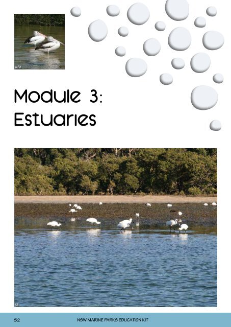
<strong>Module</strong> 3:<strong>Estuaries</strong>52<strong>NSW</strong> MARINE PARKS EDUCATION KIT
TEACHER FACT SHEET<strong>Estuaries</strong> in <strong>Marine</strong> <strong>Parks</strong>An estuary is a unique environment where flowing fresh water from a river or creek meets the saltyseawater, creating a brackish region of mixed water. Being so close to the sea, the estuary is subjected tothe daily fluctuations of the tide. The combination of the sheltered area, lack of wave energy and fine softsediment creates a very special habitat where highly specialised plants have become adept at living. Threehighly productive estuarine vegetation communities are particularly important: mangroves, saltmarshand seagrass.MangrovesMangroves are found mostly in sheltered estuarine environments, growing primarily on areas of softsediment, which form a distinct habitat known as a “mangrove forest”. Mangrove trees are well adapted tochanges in salt levels, and have developed exceptional ways of dealing with the estuarine environment.There are seven species of mangrove in <strong>NSW</strong>, of which the grey mangrove is the most common. Possibly theeasiest to recognise, it has long thin roots (known as pneumatophores) that rise vertically up through themud. Since the mud is so thick that oxygen cannot get much deeper than the first couple of centimetres,these roots act like snorkels. To get to oxygen, the mangrove sends the roots up above the mud andrespires oxygen through little holes on the pneumatophores, which then store oxygen in the plant duringhigh tide.Mangroves play a very important role for many of the animals that live in estuaries. The pneumatophores,root systems and fallen branches create a nursery habitat for juvenile prawns and fishes, such as bream,mullet, whiting and luderick. The trunks and roots also provide a home to oysters, barnacles and limpets,as well as an array of seaweeds and lichens for animals to graze on. In the branches of the mangroves it isoften possible to find some beautiful birds such as the mangrove gerygone (a mangrove specialist), thesacred kingfisher and various honeyeaters which come to enjoy the sweet mangrove blossoms.L-R: Grey mangrove (Avicennia marina) and river mangrove (Aegiceras corniculatum)JERVIS BAY MARINE PARK 53
TEACHER FACT SHEETSaltmarshSaltmarsh consists of a diverse range of grasses, saltbushes, rushesand sedges, and is found in the upper intertidal area of the shorelinein estuaries. The plants making up saltmarsh differ from one areato another. In <strong>NSW</strong>, 25 different plant compositions have beenidentified along the central <strong>NSW</strong> coast alone. Saltmarsh in southern<strong>NSW</strong> is generally more species-rich than in northern <strong>NSW</strong>.Saltmarsh improves breeding in fisheries by providing shelter, afeeding ground and a general nursery area for juvenile fishes, similarto the way that mangroves also provide a nursery habitat. Many animals use saltmarsh as feeding grounds.Fishes and crabs feed in saltmarsh during king and spring tides, and shorebirds often feed at low tide.Saltmarsh supplies a large amount of decaying organic material into food chains in estuaries. Bacteria andscavengers, such as crabs, break down the organic material (known as “detritus”) into nutrients, which inturn becomes food for fish, crabs and other crustaceans, shellfish, and then larger animals. Saltmarsh isalso very important for controlling floods and erosion, and for filtering pollution. In <strong>NSW</strong>, saltmarsh is athreatened community, with only a fraction of its original area still remaining.SeagrassSeagrasses are unique marine plants that grow in nearshore environments, estuaries and sheltered bays.Seagrasses, like their terrestrial grass cousins, are anchored to the sea floor by roots or “rhizomes”, and haveleaves with veins. They also reproduce using flowers and seeds, and require sunlight to grow.Seagrass beds are found in many marine park estuaries and are another very important habitat for a rangeof marine life. Fish, prawns and swimmer crabs are often spotted hiding and feeding amongst the seagrass.Seagrass also assists in sediment stabilisation, where it helps to reduce erosion. There are six species ofseagrass found in <strong>NSW</strong> waters, but the most common are Zostera capricorni (bottom right), Halophila ovalisand Posidonia australis (bottom left).54<strong>NSW</strong> MARINE PARKS EDUCATION KIT
TEACHER FACT SHEETEstuarine seagrass supports many coastal fisheries by providing an important area for juvenile and adultfish to hide, eat and breed in. Approximately 70% of commercially and recreationally important fish speciesin <strong>NSW</strong> rely on estuaries and their seagrass habitats at some stage in their life cycle.Management of estuariesThere are several different types of estuaries, such as drowned river valleys, barrier estuaries, which aremostly open to the tide, and coastal lagoons, which are intermittently closed and open to the tide (knownas Intermittently Closed and Open Lakes and Lagoons or ICOLLs).The importance of such estuarine systems means that they have beenincluded in <strong>NSW</strong> marine parks. Of the 133 major estuaries in <strong>NSW</strong>,approximately 50 estuaries are included in <strong>NSW</strong> marine parks.Industry and Investment <strong>NSW</strong> has management responsibilities formangroves and seagrasses, which are protected through the FisheriesManagement Act 1994. The Department of Environment, Climate Changeand Water manages saltmarsh, which is an endangered ecologicalcommunity.Popular activities in <strong>NSW</strong> marine park estuariesIndustry &Investment<strong>Estuaries</strong> provide a perfect place for recreational activities with their sheltered waters, productive habitatsand extensive waterways. Boating, swimming, recreational fishing and collecting are very popularactivities. Some estuaries are also very important for aquaculture, with oyster aquaculture present inmost tidal estuaries. Commercial tour operators provide opportunities for dolphin watching and fishing,and hire businesses supply boats, kayaks and other equipment for recreational enjoyment.JERVIS BAY MARINE PARK 55
TEACHER FACT SHEET<strong>Estuaries</strong> of the JervisBay <strong>Marine</strong> ParkThere are six estuaries in the marine park. Four are small coastal creeks (CallalaCreek, Carama Inlet, Currarong Creek and Wowly Gully), and two are largerwave-dominated estuaries (Currambene Creek and Moona Moona Creek).At present, 22% of estuarine habitats in the marine park are protected insanctuary zones, with three estuaries (Carama Inlet, Moona Moona Creek andWowly Gully) totally or predominantly included in these zones.Estuarine vegetation, such as mangroves, saltmarsh and seagrass meadows,are well-represented in the marine park, with a high percentage occurringin sanctuary zones. Two types of mangrove – the grey mangrove (Avicenniamarina) and, in the upper reaches, the river mangrove (Aegiceras corniculatum)– are found in the marine park. Some of the most extensive seagrass bedsin <strong>NSW</strong> are also found in Jervis Bay, and these are dominated by Posidoniaaustralis (strap weed), Zostera capricorni, or eelgrass (right top), and Halophilaovalis (paddle weed). Seagrasses possess extensive root systems which helpto stabilise surrounding soft sediments and, in Jervis Bay, contribute to thecrystal-clear water for which the area is known.Carama Inlet is one of the most diverse and pristine saltmarsh environmentsin <strong>NSW</strong>. The inlet is fed by clean marine waters with no significant freshwaterinflow or development on the adjacent land. The saltmarsh plain containsextensive stands of the endangered species Wilsonia backhouseii, as well as thenorthernmost stand of the shrub Sclerostegia arbuscula. Carama Inlet is whollyincluded within the Hare Bay Sanctuary Zone, which also protects one of thelargest intact seagrass beds in <strong>NSW</strong>. This meadow is dominated by Posidonia(strap weed), which has been found to contain 75 different species, includingthe more unusual spotted pipefish, bridled leatherjacket and weed whiting.Tidal flats are an important part of estuarine ecosystems as the organismsliving there are responsible for transforming nutrients and food from thesurrounding catchment into new food for marine ecosystems and fish. Over 80species of invertebrates have been recorded in the Currambene Creek MudflatSanctuary Zone, including polychaete worms, ghost shrimps (right), soldiercrabs, amphipods and molluscs. Dominant species that rely on intertidal flatsfor food, shelter or as nursery areas include bream, flathead, leatherjacket,mulloway and stingrays (right bottom).A range of shorebirds can be seen foraging around estuarine habitats, including various waders (e.g. whitefacedherons, royal spoonbills and egrets), summer migrants (such as the eastern curlew), and threatenedspecies (such as the pied oystercatcher). Terns, white-bellied sea eagles, black swans and pelicans are alsoa commonly sighted.The area of estuary outside sanctuary zones is predominantly zoned habitat protection. The primary intentof the habitat protection zoning is to protect estuarine habitats from direct human-related disturbance,such as coastal development, pollution, siltation and erosion. Fishing, boating, swimming and kayaking arepopular pastimes in the estuaries of the Jervis Bay <strong>Marine</strong> Park. The zoning plan regulates these activitiesto ensure that impact on these sensitive areas is minimised.56<strong>NSW</strong> MARINE PARKS EDUCATION KIT
STUDENT IDENTIFICATION GUIDEEstuarine Organisms of theJervis Bay <strong>Marine</strong> ParkWhite-faced heron(Egretta novaehollandiae)A diverse wetland bird thatuses its long beak to stab atprey in the water.Pelican(Pelecanus conspicillatus)This bird collects fish in alarge pouch in its lower bill.Pied oystercatcher(Haematopus longirostris)Listed as vulnerable, this birdis found on beaches feedingon pipis and nesting in thedunes.Black swan(Cygnus atratus)Often seen in shelteredestuaries, this large birdforages for algae growing onthe seagrass.Semaphore crab(Heloecius cordiformis)This crab is commonlyfound burrowing around theterrestrial fringe of mud andsand flats.Mudwhelk(Pyrazus ebeninus)Large snails that filter foodfrom the mud, these animalsare eaten by birds, octopusesand stingrays.Rock oyster(Saccostrea glomerata)The rock oyster attaches tomangrove roots and filtersplankton from the water athigh tide.Ghost shrimp(Thalassinidea spp.)This shrimp burrows inintertidal sand/mud flats andfeeds on tiny organisms in thesediment.Grey mangrove(Avicennia marina)The grey mangrovebreathes through peg roots(pneumatophores).Eelgrass(Zostera capricorni)Eelgrass provides animportant habitat for manyfish and invertebrates.Soldier crab(Mictyris platycheles)The soldier crab burrows intosandflats and mudflats, andsifts through sediment for itsfood.Polychaete worm(various species)These worms live beneath thesurface, coming out at hightide to feed.Smooth stingray(Dasyatis brevicaudata)The smooth stingray burrowsinto the sandy bottom at hightide to feed on crabs andshellfish.Yellowfin bream(Acanthopagrus australis)Bream feed on oysters, crabsand shellfish.Mullet(Mugil spp.)Mullet feed by vacuumcleaningthe mud with softlips that filter out food.Luderick(Girella tricuspidata)This fish feeds on marinealgae such as sea lettuce.Fish images by Richard Taffs, <strong>NSW</strong> Industry and Investment.JERVIS BAY MARINE PARK 57
MODULE 3 ESTUARIESStage 1 - Local PlacesTeacher Activity PlanLevelStage 1 - Local PlacesCOG Group A - Exploring Our PlaceKey Learning AreasENS1.5, ENS1.6 and DMS1.2ObjectivesThe objectives of this activity are: togather information about the naturalestuarine environment; and to increasethe understanding of relationshipsbetween animals, their environmentand humans.Excursion TimingThe excursion must be undertaken atlow tide. Check the tide times at:http://www.bom.gov.au/oceanography/tidesEquipment Used• coloured pencils• scissors• A3 paperTeacher ResourcesPlease contact the marine parkoffice on 4428 3000 for a copy of alleducational material on CD or torequest staff attendance for excursionsupport. Additional resources areavailable on:http://www.mesa.edu.auLink to habitat mapping fact sheet onsaltmarsh and estuaries:http://www.dpi.nsw.gov.au/__data/assets/pdf_file/0020/236234/mangroves.pdfAbout this programThis module is designed to cover ENS1.5, ENS1.6 and DMS1.2, and when combinedwith the other three modules in this kit, addresses the key learning areas for COGGroup A, Stage 1 - Local Places. Follow up this module with the <strong>Marine</strong> <strong>Parks</strong>, RockyShores and Sea Country modules for further insight into the local environment. Themodules are designed to address the <strong>NSW</strong> DET primary school curriculum, and canbe used to complement current teaching programs.Education material in this module consists of this Activity Plan to guide teachersthrough an excursion, a Fact Sheet to provide background information on estuaries,and an ID Guide for both teachers and students to identify the most commonanimals and plants found in estuaries.Program outlineThis program introduces some estuarine plants and animals, and providesinformation on where they live, and how they interact with each other, theirenvironment and humans.Activity 1Using the fact sheets, explain the significance of mangroves in estuaries. Copy theactivity sheets at A3 size and use the mangrove tree as a base for developing theestuary food chain. Students then, either individually or in small groups, colourthe animals, cut them out and construct the food chain below the mangrove treeusing arrows to link the chain together (see the example on p.59). The animalsshould be represented on the diagram in their preferred habitat. Illustrate thepage further with other animals that live in the estuary, such as crabs in the mud,insects in the trees, yabbies under the mud, etc.Reiterate how important mangroves are to all of these animals, and why thesehabitats need to be cared for.Optional excursionFollow up with an excursion to your nearest estuary to meet the inhabitants inperson. Use the ID guide to identify some of the plants and animals found in theestuary, and tick them off “bingo”-style when you have found them.During the excursion, discuss which zone the estuary is in (refer to the JervisBay <strong>Marine</strong> Park zoning guide provided in <strong>Module</strong> 1). Mud crab trapping andrecreational line fishing are permitted in the habitat protection zone but not in thesanctuary zone. Which would you guess has a healthier population (larger numbersand larger sized animals) of fishes and crabs? Use the <strong>Estuaries</strong> Risk Analysis (pp.74-75) to ensure student safety.Possible locations within the Jervis Bay <strong>Marine</strong> Park• Currambene Creek• Moona Moona Creek• Callala Creek58<strong>NSW</strong> MARINE PARKS EDUCATION KIT
Develop an Estuary Food Chain - EXAMPLESeagrass Snail Small fish Big fish BirdJERVIS BAY MARINE PARK 59
Activity Sheet - Develop an Estuary Food Chain60<strong>NSW</strong> MARINE PARKS EDUCATION KIT
Activity Sheet - Develop an Estuary Food ChainJERVIS BAY MARINE PARK 61
MODULE 3 ESTUARIESStage 2 - Local EnvironmentsTeacher Activity PlanLevelStage 2 - Local EnvironmentsCOG Group A - Exploring Our PlaceKey Learning AreasENS2.5, ENS2.6, SLS2.13, PSS2.5ObjectivesThe objectives of this activity are: toidentify local estuarine species; to usea range of problem-solving strategieswhen faced with issues in the naturalenvironment; to identify who to contactin order to solve a localised problem;and to understand the differencebetween zones within marine parkestuaries.Excursion TimingThe excursion must be undertaken atlow tide. Check the tide times at:http://www.bom.gov.au/oceanography/tidesEquipment Used• pencils• sustainable bags• rubber gloves• clipboardsTeacher ResourcesPlease contact the marine parkoffice on 4428 3000 for a copy of alleducational material on CD or torequest staff attendance for excursionsupport. Additional resources areavailable on:http://www.mpa.nsw.gov.auhttp://www.cleanup.org.au/auhttp://www.waterwatch.nsw.gov.auhttp://www.dpi.nsw.gov.au/fisheries/recreational/saltwater/sw-species/tiger-flathead2http://www.ozcoasts.org.au/geom_geol/toolkit/mapfish.jspAbout this programThis module is designed to cover ENS2.5, ENS2.6, SLS2.13 and PSS2.5, and whencombined with the other three modules in this kit, addresses the key learning areasfor COG Group A, Stage 2 - Local Environments. Follow up this module with the<strong>Marine</strong> <strong>Parks</strong>, Rocky Shores and Sea Country modules for further insight into thelocal environment. The modules are designed to address the <strong>NSW</strong> DET primaryschool curriculum, and can be used to complement current teaching programs.Education material in this module consists of this Activity Plan to guide teachersthrough an activity, Fact Sheets to provide background information on estuaries, astudent Work Sheet to record information, and an ID Guide for both teachers andstudents to identify the most common animals and plants found in estuaries.Activity 1 - ExcursionChoose a local estuary to visit and use as a case study. Use the ID guide to findsome of the local inhabitants, and also look for signs of animals, such as whelktracks through the mud, spider webs, and yabby and crab holes. Outline howimportant the plants are as both a food source and home for the resident animals.Discuss the place where the animals are found, and how important it is for them tohave a safe home. How are these animals affected by human activities?While in the field, discuss the issue of litter and pollution, and how it washes intothe ocean to become marine debris. Reiterate that what happens on land influencesthe ocean: litter in rivers ends up as litter in oceans. Introduce the concept ofstorm water drains and rubbish catchers. Ask the students whether they would goswimming where it is heavily littered or polluted.What can we do about this problem? We can help by:• not littering• picking up the rubbish we see• participating in local “Clean Up Australia” days• organising school clean up events, especially after heavy rains• reporting pollution spills to the local council.Using the litter survey sheet, conduct a clean up along the shores of your localestuary. Remember to estimate the length of the foreshore you have cleared. At theend, tally the results and congratulate the students on preventing the rubbish theyhave collected from entering the ocean. Use the <strong>Estuaries</strong> Risk Analysis (pp.74-75)to ensure student safety.Possible locations within the Jervis Bay <strong>Marine</strong> Park• Currambene Creek• Moona Moona CreekActivity 2Use the flathead activity to illustrate the benefits of sanctuary (or no fishing) zonescompared to areas that can be fished. (Refer to the fact sheets and the Jervis Bay<strong>Marine</strong> Park zoning guide provided in <strong>Module</strong> 1 for background information). Thisactivity reflects research that has been conducted throughout various marine parksin Australia.• Print out the flathead image in different sizes.• Explain the activity to the students using the teacher activity sheet.• Help the students to graph their results.• Discuss the benefits of protected areas as outlined in the fact sheets for <strong>Module</strong>s1 and 3.• Write up the key findings on the fish and display them in the classroom.62<strong>NSW</strong> MARINE PARKS EDUCATION KIT
Activity Sheet: Litter SurveyArea of estuary bank surveyed (length in metres): . . . . . . . . . . . . . . . . .ConfectioneryLolly sticksWrappersBeveragesGlass bottles and piecesPlastic bottles and cupsPlastic caps, straws and utensilsPaper cupsTetra boxes (such as Popper Juice cartons)Aluminium cansStyrofoam cups/piecesMetal caps, ring pulls and piecesOrganicFoodPlastic FilmPlastic film/cling wrapPlastic bagsPlastic wrappersPlastic piecesPaperPaper bagsServiettes and tissuesPaper piecesNewspaperAdvertising materialsTakeaway boxesCardboard boxes and piecesCigarettesCigarette buttsCigarette packets, wrappers, foil and matchesUnidentifiedTotal =Total =Total =Total =Total =Total =Total =QuantityQuantityQuantityQuantityQuantityQuantityQuantityTotal number of litter items collected: . . . . . . . . . . . . . . . . . . . . . . . . . . . .JERVIS BAY MARINE PARK 63
Activity Sheet - Flathead Teacher ReferenceBackgroundThe aim of this activity is to highlight the benefit of protective zoning for species in marine parks. The activityis based on research conducted in <strong>NSW</strong> marine parks comparing the number and size of invertebrates(specifically mud crabs) found in areas that are fished and those that are not fished. This hypotheticalexercise uses flathead as an example of a species that would benefit from protective zoning. The resultsof this simple exercise should show that, in general, there are more fish and larger fish in sanctuary zones(areas that are not fished) when compared to areas that are open to fishing.The flathead is a fish commonly found in estuaries and coastal areas in Australian waters. There are severaldifferent species of flathead, with some occurring in southern waters and others in northern tropical waters.Flathead are a popular target species with fishers. The legal minimum length for the dusky or commonflathead is 36cm. They can be caught using baitfish such as poddy mullet. The bag limit is 10, with only oneover 70cm.One method for collecting information on the number and size of fish in different areas is with the useof underwater stereo video cameras, which are left underwater for a specific period of time (for example,30 minutes). A bait bag is attached to a pole in front of the camera to attract fish. The fish are filmed, andfootage is reviewed back in the office. This allows a researcher to study the fish assemblages and sizes in avariety of locations both within and outside of sanctuary zones without capturing or harming the fish.Activity• Print out the fish at a range of different sizes, cut them out, and laminate them if time permits. 15 to 20should be sufficient.• Allocate eight areas on the floor: four sanctuary zones and an additional four areas that are non-sanctuaryzones. Label these areas as such.• Place the fish into their “study sites” around the room, with more fish and larger fish in sanctuary zonesthan non-sanctuary zones, thus representing what was captured on camera.• Break the class into small groups/pairs to make measuring easier.• Each group/pair should have a data sheet (student activity sheet), a pen and a ruler.• Students then rotate around the eight sites, entering data on the sheet by: (1) recording the number offish at each site, and (2) measuring the length of each fish at each site with a ruler.• Next calculate the mean sizes of fish for sanctuary zones and non-sanctuary zones, and graph the results.The final step is to calculate the total number of fish in each zone and compare the difference betweenzones.• At the end of the activity, discuss the results with the students and come up with some key points.These can be written on the back of the fish and then pinned up around the room or on a board. Someexample discussion points may include:• Flathead like to live in estuaries.• <strong>Estuaries</strong> are important habitats for many animals.• Fishers like to catch flathead.• Sanctuary zones are important refuge sites for fish where they are unlikely to be caught.• We can go fishing in habitat protection zones but not sanctuary zones.64<strong>NSW</strong> MARINE PARKS EDUCATION KIT
• Flathead can grow larger in protected areas as they are less likely to be caught by fishers.• Fish may be smaller in unprotected zones as they are more likely to be caught by fishers when theyare young.• Fish can also be impacted by pollution (litter, chemicals, etc.) and a range of other impacts adjacentto estuaries.• Areas outside sanctuary zones that have little to no fish are either popular fishing sites OR the sitemay not be the preferred habitat for flathead.• Areas inside sanctuary zones that have large numbers of fish are protected from capture and/or arethe perfect habitat for the fish (e.g. an area with a sandy bottom and places to hide).Below is an example of some results for the fish measuring exercise. The students’ results may look similarto this.Average length ofeach fish caught(cm)Sanctuary ZoneNon-Sanctuary ZoneArea 1 Area 2 Area 3 Area 4 Area 1 Area 2 Area 3 Area 445 32 42 35 34 0 27 2530 26 40 3340 3822Number of fish caught 4 3 1 2 1 0 2 1Total number of fish 10 4Average sizes of fish 34.5 32 42 37.5 34 0 30 25Average size of allsanctuary fish = 36.5cmAverage size of allnon-sanctuary fish = 22cmAverage size of fish in mm4035302520151050Sanctuary ZoneNon-Sanctuary Zone12Number of fish1086420Sanctuary ZoneNon-Sanctuary ZoneJERVIS BAY MARINE PARK 65
66<strong>NSW</strong> MARINE PARKS EDUCATION KIT
Activity Sheet - Flathead Data SheetIntroductionActivity<strong>Estuaries</strong> are areas where rivers meet the sea.They are very special habitats that are importantto many plants and animals. Flathead love to livein the soft, muddy sediment ofestuaries.You are a researcher studying the sizes of flatheadin sanctuary (no fishing) zones and non-sanctuary(fishing) zones. In small groups:1.Measure the size and count the number offish at each site.2.3.4.Record the details in the table below.Get your teacher to help you calculate themean sizes of the fish.To show the difference between the numbersand sizes of fish between the sanctuary andnon-sanctuary zones, fill in the graphs overthe page. (Your teacher will show you howto enter these results in.)Sanctuary ZoneNon-Sanctuary ZoneArea 1 Area 2 Area 3 Area 4 Area 1 Area 2 Area 3 Area 4Average length ofeach fish caughtNumber of fish caughtTotal number of fishAverage sizes of fishAverage size of allsanctuary fish = . . . . .Average size of allnon-sanctuary fish = . . . . .JERVIS BAY MARINE PARK 67
Results4035Average size of fish in mm302520151050Sanctuary ZoneNon-Sanctuary Zone1210Number of fish86420Sanctuary ZoneNon-Sanctuary ZoneDiscussionWhich column shows the highest number of fish? .......................................................Which column shows the largest fish measured? ........................................................What does this tell you about sanctuary zones? . . . . . . . . . . . . . . . . . . . . . . . . . . . . . . . . . . . . . . . . . . . . . . . . . . . . . . . . .. . . . . . . . . . . . . . . . . . . . . . . . . . . . . . . . . . . . . . . . . . . . . . . . . . . . . . . . . . . . . . . . . . . . . . . . . . . . . . . . . . . . . . . . . . . . . . . . . . . . . . . .. . . . . . . . . . . . . . . . . . . . . . . . . . . . . . . . . . . . . . . . . . . . . . . . . . . . . . . . . . . . . . . . . . . . . . . . . . . . . . . . . . . . . . . . . . . . . . . . . . . . . . . .. . . . . . . . . . . . . . . . . . . . . . . . . . . . . . . . . . . . . . . . . . . . . . . . . . . . . . . . . . . . . . . . . . . . . . . . . . . . . . . . . . . . . . . . . . . . . . . . . . . . . . . .68<strong>NSW</strong> MARINE PARKS EDUCATION KIT
MODULE 3 ESTUARIESStage 3 - Living LandTeacher Activity PlanLevelStage 3 - Living LandCOG Group A - Exploring Our PlaceKey Learning AreasENS3.5, ENS3.6, DRAS3.1, DRAS3.2,DRAS3.3, DRAS3.4, MUS3.3ObjectivesThe objectives of this activity are: todevelop an understanding throughrole-play of the different interestsheld by stakeholders and users ofmarine parks; and to determine howsuch groups can act in an ecologicallyresponsible manner.Excursion TimingThe excursion must be undertaken atlow tide. Check the tide times at:http://www.bom.gov.au/oceanography/tidesEquipment Used• paper• pencilsTeacher ResourcesPlease contact the marine parkoffice on 4428 3000 for a copy of alleducational material on CD or torequest staff attendance for excursionsupport. Additional resources areavailable on:http://www.mesa.edu.auLink to habitat mapping fact sheets onsaltmarsh and estuaries:http://www.dpi.nsw.gov.au/__data/assets/pdf_file/0020/236234/mangroves.pdfhttp://www.waterwatch.nsw.gov.auAbout this programThis module is designed to cover ENS3.5, ENS3.6, DRAS3.1, DRAS3.2, DRAS3.3,DRAS3.4 and MUS3.3, and when combined with the other three modules in thiskit, addresses the key learning areas for COG Group A, Stage 3 - Living Land. Followup this module with the <strong>Marine</strong> <strong>Parks</strong>, Rocky Shores and Sea Country modules forfurther insight into the local environment. The modules are designed to addressthe <strong>NSW</strong> DET primary school curriculum, and can be used to complement currentteaching programs.Education material in this module consists of this Activity Plan to guide teachersthrough this group activity, a Fact Sheet to provide background information onestuaries, a student Work Sheet for gathering information in the field, an ID Guidefor both teachers and students to identify the most common animals and plantsfound in estuaries, and Information Cards to help students understand the groupthey are representing in their debate.Activity 1 - ExcursionChoose an estuary in the local area. Using the fact sheets provided and anyadditional resources, students then undertake research on that estuary. (ActivitySheet 1 will help to guide their research.)Visit this estuary on an excursion. Introduce the program, and brief the class on thesafety issues involved with the excursion using the <strong>Estuaries</strong> Risk Analysis (pp.74-75). Break the class into small groups and explain that the information they gatherwill eventually lead to a role-play back in the classroom (see Activity 2).On a large piece of paper, get the students to draw an outline of the estuary,illustrating where the major habitat types are (mangrove, seagrass, etc.). Includeother features of interest, such as jetties, ramps, boardwalks and shops.Note: If an excursion is not possible, display a photo of a local estuary in theclassroom. You could also use Google Earth or Google Maps to help identify someof the features in the surrounding area.Activity 2This activity outline is a guide only that can be modified by staff into an interactiveclass activity. Break the class into groups and hand out the cards to the students,informing them of their group’s issues (use as few or as many as necessary). Intheir groups, the students are to formulate a discussion/debate supporting theirstakeholder group.Each group will have positive and negative points that the debaters must emphasiseto illustrate their point. The group then chooses a representative to debate theircause.The outcome is for the class to come to a decision on how the estuary is to bemanaged sustainably while trying to satisfy the desires of the different stakeholders.Use the estuary drawing to help plan the outcome. Discuss this as a class, asking“What can the estuary cope with?” and “What will the impacts be?”, and keep inmind that:• The estuary can be divided into different zones to accommodate all activities.• Conditions can be made. For example: line fishing can occur in some areasbut not in others, or not at certain times of the year; or perhaps building cango ahead as long as the structure is a certain distance from the water’s edge,complies with environmental standards so that as little impact occurs on thenatural environment as possible, barriers are put up to stop waste enteringthe water, and, to compensate for habitat that is destroyed, areas that needrevegetation are replanted.JERVIS BAY MARINE PARK 69
Activity Sheet 1 - Research a LocalEstuaryAnswer the following questions, and then write a paragraph describing the estuary.The marine park fact sheet may help you answer some of these questions.1.Is the estuary open to the ocean?. . . . . . . . . . . . . . . . . . . . . . . . . . . . . . . . . . . . . . . . . . . . . . . . .2. Does the estuary include the followingvegetation? Use the ID guide to help youidentify these plants. Tick “yes” or “no”, and thenestimate the amount of vegetation present byplacing a tick in the appropriate box.Vegetation Yes/No Sparse Patchy DenseSeagrassMangrovesSaltmarsh6. Is there rubbish in the water and/or along thebanks?. . . . . . . . . . . . . . . . . . . . . . . . . . . . . . . . . . . . . . . . . . . . . . . . .. . . . . . . . . . . . . . . . . . . . . . . . . . . . . . . . . . . . . . . . . . . . . . . . .7. Are you allowed to fish here? If so, is it a goodfishing spot? (Can you see people fishing fromthe banks or in boats?). . . . . . . . . . . . . . . . . . . . . . . . . . . . . . . . . . . . . . . . . . . . . . . . .8. Is there a walking track or boardwalk for peopleto access the estuary?. . . . . . . . . . . . . . . . . . . . . . . . . . . . . . . . . . . . . . . . . . . . . . . . .WeedsPaperbarksShe-oaks9. Are there any local Aboriginal sites (such asmiddens) along this estuary?. . . . . . . . . . . . . . . . . . . . . . . . . . . . . . . . . . . . . . . . . . . . . . . . .3.Does the estuary have a large or small catchmentarea?. . . . . . . . . . . . . . . . . . . . . . . . . . . . . . . . . . . . . . . . . . . . . . . . .. . . . . . . . . . . . . . . . . . . . . . . . . . . . . . . . . . . . . . . . . . . . . . . . .4. Is the land around the estuary flat or hilly?. . . . . . . . . . . . . . . . . . . . . . . . . . . . . . . . . . . . . . . . . . . . . . . . .5. Does the land around the estuary have manybuildings (houses, schools, shops, etc.)?. . . . . . . . . . . . . . . . . . . . . . . . . . . . . . . . . . . . . . . . . . . . . . . . .. . . . . . . . . . . . . . . . . . . . . . . . . . . . . . . . . . . . . . . . . . . . . . . . .10. Use this information to describe this estuaryand its importance for natural, communityand cultural values.. . . . . . . . . . . . . . . . . . . . . . . . . . . . . . . . . . . . . . . . . . . . . . . . .. . . . . . . . . . . . . . . . . . . . . . . . . . . . . . . . . . . . . . . . . . . . . . . . .. . . . . . . . . . . . . . . . . . . . . . . . . . . . . . . . . . . . . . . . . . . . . . . . .. . . . . . . . . . . . . . . . . . . . . . . . . . . . . . . . . . . . . . . . . . . . . . . . .. . . . . . . . . . . . . . . . . . . . . . . . . . . . . . . . . . . . . . . . . . . . . . . . .. . . . . . . . . . . . . . . . . . . . . . . . . . . . . . . . . . . . . . . . . . . . . . . . .. . . . . . . . . . . . . . . . . . . . . . . . . . . . . . . . . . . . . . . . . . . . . . . . .. . . . . . . . . . . . . . . . . . . . . . . . . . . . . . . . . . . . . . . . . . . . . . . . .70<strong>NSW</strong> MARINE PARKS EDUCATION KIT
Activity Sheet 2 - Debating for SustainabilityIn small groups you will be assigned a “stakeholder” group that your team will be representing: either adeveloper, a conservationist, a group of local Aboriginal Elders, a tourist operator, a recreational fisher, ora researcher.Look back on the information you gathered from the estuary research to help make your point. Using thecards you have been given, plan a discussion for your group. Use this page to help make an argument torepresent your group.Each stakeholder group will then make a presentation, outlining the ways in which they would like to seethe estuary managed for future generations. Developers should speak first.Aim. . . . . . . . . . . . . . . . . . . . . . . . . . . . . . . . . . . . . . . . . . . . . . . . .. . . . . . . . . . . . . . . . . . . . . . . . . . . . . . . . . . . . . . . . . . . . . . . . .. . . . . . . . . . . . . . . . . . . . . . . . . . . . . . . . . . . . . . . . . . . . . . . . .. . . . . . . . . . . . . . . . . . . . . . . . . . . . . . . . . . . . . . . . . . . . . . . . .. . . . . . . . . . . . . . . . . . . . . . . . . . . . . . . . . . . . . . . . . . . . . . . . .. . . . . . . . . . . . . . . . . . . . . . . . . . . . . . . . . . . . . . . . . . . . . . . . .. . . . . . . . . . . . . . . . . . . . . . . . . . . . . . . . . . . . . . . . . . . . . . . . .. . . . . . . . . . . . . . . . . . . . . . . . . . . . . . . . . . . . . . . . . . . . . . . . .. . . . . . . . . . . . . . . . . . . . . . . . . . . . . . . . . . . . . . . . . . . . . . . . .. . . . . . . . . . . . . . . . . . . . . . . . . . . . . . . . . . . . . . . . . . . . . . . . .. . . . . . . . . . . . . . . . . . . . . . . . . . . . . . . . . . . . . . . . . . . . . . . . .. . . . . . . . . . . . . . . . . . . . . . . . . . . . . . . . . . . . . . . . . . . . . . . . .. . . . . . . . . . . . . . . . . . . . . . . . . . . . . . . . . . . . . . . . . . . . . . . . .Key Messages. . . . . . . . . . . . . . . . . . . . . . . . . . . . . . . . . . . . . . . . . . . . . . . . .. . . . . . . . . . . . . . . . . . . . . . . . . . . . . . . . . . . . . . . . . . . . . . . . .. . . . . . . . . . . . . . . . . . . . . . . . . . . . . . . . . . . . . . . . . . . . . . . . .. . . . . . . . . . . . . . . . . . . . . . . . . . . . . . . . . . . . . . . . . . . . . . . . .. . . . . . . . . . . . . . . . . . . . . . . . . . . . . . . . . . . . . . . . . . . . . . . . .. . . . . . . . . . . . . . . . . . . . . . . . . . . . . . . . . . . . . . . . . . . . . . . . .. . . . . . . . . . . . . . . . . . . . . . . . . . . . . . . . . . . . . . . . . . . . . . . . .. . . . . . . . . . . . . . . . . . . . . . . . . . . . . . . . . . . . . . . . . . . . . . . . .. . . . . . . . . . . . . . . . . . . . . . . . . . . . . . . . . . . . . . . . . . . . . . . . .. . . . . . . . . . . . . . . . . . . . . . . . . . . . . . . . . . . . . . . . . . . . . . . . .. . . . . . . . . . . . . . . . . . . . . . . . . . . . . . . . . . . . . . . . . . . . . . . . .. . . . . . . . . . . . . . . . . . . . . . . . . . . . . . . . . . . . . . . . . . . . . . . . .. . . . . . . . . . . . . . . . . . . . . . . . . . . . . . . . . . . . . . . . . . . . . . . . .. . . . . . . . . . . . . . . . . . . . . . . . . . . . . . . . . . . . . . . . . . . . . . . . .. . . . . . . . . . . . . . . . . . . . . . . . . . . . . . . . . . . . . . . . . . . . . . . . .. . . . . . . . . . . . . . . . . . . . . . . . . . . . . . . . . . . . . . . . . . . . . . . . .. . . . . . . . . . . . . . . . . . . . . . . . . . . . . . . . . . . . . . . . . . . . . . . . .. . . . . . . . . . . . . . . . . . . . . . . . . . . . . . . . . . . . . . . . . . . . . . . . .. . . . . . . . . . . . . . . . . . . . . . . . . . . . . . . . . . . . . . . . . . . . . . . . .. . . . . . . . . . . . . . . . . . . . . . . . . . . . . . . . . . . . . . . . . . . . . . . . .. . . . . . . . . . . . . . . . . . . . . . . . . . . . . . . . . . . . . . . . . . . . . . . . .. . . . . . . . . . . . . . . . . . . . . . . . . . . . . . . . . . . . . . . . . . . . . . . . .. . . . . . . . . . . . . . . . . . . . . . . . . . . . . . . . . . . . . . . . . . . . . . . . .JERVIS BAY MARINE PARK 71
DeveloperThe land on the bank of this estuary is perfect for development. We want to build a newhousing complex here because:• The units will have estuarine and sea views, which will attract people to buy the units, whichincreases our profits.• We can attract people to live here who love to fish.• No one needs or uses this part of the estuary, and it’s full of sandflies. We will fill in the mudwith concrete and make it look great by planting beautiful gardens.• It will be a great place for tourists to come and stay, and they will spend money in our localshops.ConservationistThis estuary has a range of habitat types, such as (describe what was found on the excursion),which are homes to a large variety of animals. Fishes and crabs use these areas as nurserygrounds, so we need to protect a large amount of this habitat. If the estuary is damaged, allthe young fishes might die.Seagrass and mangroves are protected through the Fisheries Management Act, and it is illegalto destroy them.Mangroves are important in reducing erosion of the nearby land from water movement, andto filter pollutants from runoff.If hundreds of people come here, they will have a huge impact on this area by increasing thelevels of rubbish and pollution.Local Aboriginal Elders GroupOur people have been using this estuary for thousands of years. We still use the bay today toharvest fish, and we don’t want them to be poisoned or moved away because of pollution ordamage caused by new buildings.There is a midden site here where our ancestors left shell and bone remains many years ago,and this area is sacred to us.Some of the mangrove trees are scar trees where we cut out our shields, so we also want thesetrees preserved.We don’t want large numbers of people trampling our sacred sites.72<strong>NSW</strong> MARINE PARKS EDUCATION KIT
Tourist OperatorSuch a beautiful environment will attract many tourists! We can attract hundreds of people toexplore this estuary, and hire out motor boats to them, and organise fishing events.We will need more tourist accommodation: maybe a caravan park near by, some toilet blocksand some barbeque areas.This natural environment is perfect for eco-tourism. We can provide canoeing tours, guidedwalking tours and bird watching events.We can increase visitors’ spending money in our local community by advertising, and evenattract people here from all over the world.Recreational FisherOur families have been fishing in these waters for generations. We have always caught goodnumbers of fish here.This estuary is important to the locals and needs to be kept local. This is where we catch ourdinner! Lots of new people will reduce fish stocks and damage the habitat.A new boat ramp would be good, though, for better access to the estuary.We don’t want too many “outsiders” coming in here, competing for – and scaring off – ourfish.ResearcherThis estuary is an ICOLL, so it is not always open to the sea. Studies show it is very sensitive topollution because of this feature as not much new water gets in.Any changes to the land surrounding the estuary may increase pollution.Research shows this estuary is an important area for juvenile fishes and shellfish, and containsvaluable seagrass beds.According to climate change research, the sea is predicted to rise, so any new developmentsmust be carefully considered.JERVIS BAY MARINE PARK 73
<strong>Estuaries</strong> Risk AnalysisLocation: Project/Job Name/No: Date:Work Activity/Task: School excursion toestuary.Staff consulted:Signature:ItemJob stepBreak the jobdown into steps.Potential dangersand incidentsRiskratingControls to prevent incidentsWhat you are going to do to make the job assafe as reasonably practicable.Person whowill ensurethis happens1 Communicationswith staffParticipant getslost/Accident/Other unforeseeneventM • Make role calls at regular intervals,including commencement and finish, andimplement a buddy system setup.• Give a safety brief to participants at thebeginning of the activity.Teaching staff• Advise administration staff of departureand arrival times.• Ensure at least one staff member hasrelevant first aid certification.• Carry a mobile phone, map and first aidkit.2 WeatherconditionsStorm conditions/ExposureM• Ensure mobile phones are charged beforedeparture.• Check the weather and tides prior toleaving for the activity. (The activity mustbe undertaken at low tide.)Teaching staff• Ensure participants are correctly attired(i.e. with a hat, long-sleeved shirt, or ajacket if it is cold or rainy), and includesuch needs on the excursion consentform.3 Wet, slipperyboardwalk/Muddy areasFalling over andsubsequent injury,such as cuts orsprains• Have sunscreen and water available forparticipants, and include such needs onthe excursion consent form.M • Brief participants on the care neededwhen walking on slippery surfaces.• Review the study area and identifyslippery patches and trip hazards.Teaching staff• Ensure that all participants haveappropriate footwear, and include suchneeds on the excursion consent form.74<strong>NSW</strong> MARINE PARKS EDUCATION KIT
ItemJob stepBreak the jobdown into steps.Potential dangersand incidentsRiskratingControls to prevent incidentsWhat you are going to do to make the job assafe as reasonably practicable.Person whowill ensurethis happens4 Falling into estuary Drowning H • Ensure sufficient staff are in attendance toprovide the appropriate “high risk” levelof supervision.5 Dangerous fauna Snakes andstingraysM• Brief participants on the care needednear the water (e.g. stay away from theedge of boardwalks and the estuaryedge, and make sure a “buddy” system isimplemented).• Ensure participants are sensible aroundthe water’s edge.• Ensure participants are visible at all times.• Warn children to watch where they walk.If a snake is sighted, they are to stopwalking and inform a teacher.• Students are not to walk in the water;however, if this is necessary, then they areto shuffle their feet so as to kick stingraysout of the way.6 Cuts Broken glass M • Make children aware of any broken glass,tell them not to touch it, and let the staffpick it up.• Wear appropriate footwear.Teaching staffTeaching staffTeaching staffReviewed by:______________________________________________Principal/Executive______________________________________________Signature________/_______/_________DateRisk Assessment Rating:E Extreme risk; immediate action requiredH High risk; senior management attention neededM Moderate risk; management responsibility must be specifiedL Low risk; manage by routine procedures.JERVIS BAY MARINE PARK 75