- Page 1: Alberta Instituteof PedologyUnivers
- Page 4 and 5: CHAPTER V - ECOLOGICAL INTEGRATION
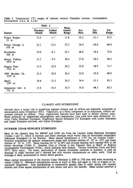
- Page 6 and 7: TABLES1 . Temperature (°C) ranges
- Page 8 and 9: Wildlife features of Cutbank (CT) E
- Page 10 and 11: 18. Sampled Eluviated Dystric Bruni
- Page 12 and 13: 53. RD3 sample site with the heathe
- Page 14 and 15: ABSTRACTMount Revelstoke and Glacie
- Page 16 and 17: NFig . 1 . Location and drainage sy
- Page 20 and 21: o'Table 2 . Temperature data (°C)
- Page 22 and 23: Table 4. Snow depths for stations i
- Page 24 and 25: STRUCTURAL FRAMEWOR KBedrock in the
- Page 26 and 27: area (Fulton et al. 1984) which inc
- Page 28 and 29: Table 6. Characteristics of Residuu
- Page 30 and 31: Table 7. Characteristics of colluvi
- Page 32 and 33: Table 8 . Characteristics of morain
- Page 34 and 35: Table 9 . Characteristics of Ice Co
- Page 36 and 37: Fig . 5 . Textural variation among
- Page 38 and 39: ORGANIC COMPONENTThe organic landfo
- Page 40 and 41: Soil Reaction : with a pH meter usi
- Page 42 and 43: BRUNISOLIC SOIL SBrunisolics occur
- Page 44 and 45: Gleysolics are most common on flat
- Page 46 and 47: CHAPTER III - VEGETATIO NP .L .Achu
- Page 48 and 49: Fig . 6 . Ecoregions of Mount Revel
- Page 50 and 51: ALPINE ECOREGIO NThe Alpine Ecoregi
- Page 52 and 53: C14 is mature successionally with s
- Page 54 and 55: In the western Cascades of Washingt
- Page 56 and 57: Table 17 . Stands of the balsam pop
- Page 58 and 59: C47: Tsuga mertensiana-Abies lasioc
- Page 60 and 61: Table 20 . Stands of the Engelmann
- Page 62 and 63: Table 22 . Stands of the western he
- Page 64 and 65: Table 23 . Stands of the western re
- Page 66 and 67: Binkley and Graham (1981) describe
- Page 68 and 69:
Table 26. Stands of the Engelmann s
- Page 70 and 71:
011 : Picea spp ./Ledum groenlandic
- Page 72 and 73:
Table 29 . Stands of the aspen-west
- Page 74 and 75:
Vegetation : The tree layer is open
- Page 76 and 77:
Table 32 . Stands of the subalpine
- Page 78 and 79:
Table 34 . Stands of the subalpine
- Page 80 and 81:
Table 36 . Stands of the willow-mou
- Page 82 and 83:
Table 38 . Stands of the alder/skun
- Page 84 and 85:
Table 40. Stands of the mountain av
- Page 86 and 87:
Other Studies : H2 is also describe
- Page 88 and 89:
Vegetation : Carex aquatilis (50-80
- Page 90 and 91:
Table 45 . Stands of the fleabane-v
- Page 92 and 93:
H21 : Carex spp .(sedge )Environmen
- Page 94 and 95:
species not climax for the site . S
- Page 96 and 97:
calcareous conditions are more comm
- Page 98 and 99:
SAMPLING RATIONALEMethods were chos
- Page 100 and 101:
third are highly important . The fi
- Page 102 and 103:
SMALL MAMMAL ASSOCIATION 1Shrubland
- Page 104 and 105:
Avalanche alder shru bSMALL MAMMAL
- Page 106 and 107:
Definitive Speciesfreq . dens . fre
- Page 108 and 109:
Vegetation Type correlate swillow/h
- Page 110 and 111:
Upper Subalpine coniferous closed f
- Page 112 and 113:
Vegetation Type correlatessubalpine
- Page 114 and 115:
RemarksThe average DI is 4 .1 .In t
- Page 116 and 117:
Additional SpeciesHermit Thrush .09
- Page 118 and 119:
Brown Creeper .073 Nashville Warble
- Page 120 and 121:
CHAPTER V • ECOLOGICAL INTEGRATIO
- Page 122 and 123:
EcosectionsEcoregions are conceptua
- Page 124 and 125:
ECOLOGICAL (BIOPHYSICAL) LEGEND COR
- Page 126 and 127:
Fig . 8 . Landscape schematic of to
- Page 128 and 129:
Table 50 . Wildlife features of AB
- Page 130 and 131:
Current landform construction is ve
- Page 132 and 133:
Table 52. Wildlife features of AK E
- Page 134 and 135:
Fig . 10 . Landscape schematic of t
- Page 136 and 137:
Table 54 .EcositeWildlife features
- Page 138 and 139:
Table 56 . Wildlife features of CE
- Page 140 and 141:
Table 58 . Wildlife features of CM
- Page 142 and 143:
Fig. 11 . Landscape schematic of to
- Page 144 and 145:
Table 60. Wildlife features of CT E
- Page 146 and 147:
GF - GRIFFITH ECOSECTIO NThe Griffi
- Page 148 and 149:
WILDLIFEGF is the most important to
- Page 150 and 151:
Table 63 . Definitive features of t
- Page 152 and 153:
GEOMORPHOLOGYHE3 is geomorphically
- Page 154 and 155:
Table 67. Definitive features of He
- Page 156 and 157:
wash and soil creep . A few tracts
- Page 158 and 159:
Table 68 .Wildlife features of HR E
- Page 160 and 161:
Table 69 . Definitive features of J
- Page 162 and 163:
Table 70 . Wildlife features of JD
- Page 164 and 165:
GEOMORPHOLOG YThe predominant genet
- Page 166 and 167:
KX - KUSKANAX ECOSECTIONThe Kuskana
- Page 168 and 169:
Table 75 . Definitive features of t
- Page 170 and 171:
and aprons are a poorly sorted, til
- Page 172 and 173:
NC3, and NC4 have the same hemlock
- Page 174 and 175:
from Bm and Bf (Brunisolic soils) t
- Page 176 and 177:
Table 80 .Wildlife features of NC E
- Page 178 and 179:
Table 81 . Definitive features of R
- Page 180 and 181:
WILDLIFESMA 13 is assumed to be pre
- Page 182 and 183:
Such soils indicate episodic deposi
- Page 184 and 185:
WILDLIFEWR1 Wildlife FeaturesUngula
- Page 186 and 187:
MISCELLANEOUS LANDSCAPE SCR - COLLU
- Page 188 and 189:
unvegetated . A few tracts have spa
- Page 190 and 191:
Bamberg, S .A. and J . Major . 1968
- Page 192 and 193:
Day, D., C. Zinkan and G. Wickware
- Page 194 and 195:
Jurdant, M., D .S . Lacate, S .C. Z
- Page 196 and 197:
Ogilvie, R .T . 1976 . The Alpine a
- Page 198 and 199:
Sneddon, J .I ., L.M . Lavkulich, a
- Page 200 and 201:
Whittaker, R .H . 1967 . Gradient a
- Page 202 and 203:
POLYPODIACEAEAdiantum pedatum L . v
- Page 204 and 205:
Sambucus racemosa L. var . melanoca
- Page 206 and 207:
CORNACEAECornus canadensis L .Cornu
- Page 208 and 209:
LABIATAEGaleopsis tetrahit L .Lycop
- Page 210 and 211:
Anemone parviflora Michx. G tAquile
- Page 212 and 213:
Tellima grandiflora (Pursh) Dougl .
- Page 214 and 215:
GRAMI NEA Ex Agroelymus mossii Lepa
- Page 216 and 217:
ORCHIDACEA ECorallorhiza maculata R
- Page 218 and 219:
Dicranella heteromalla (Hedw .) Sch
- Page 220 and 221:
Bryoria pseudofuscescens (Gyeln.) B
- Page 222 and 223:
Usnea scabrata Nyl . RXanthoria ele
- Page 224 and 225:
Turkey Vulture Cathartes aura (Linn
- Page 226 and 227:
Lazuli Bunting Passerina amoena (Sa
- Page 228 and 229:
APPENDIX C - CORRELATION OF MAP UNI
- Page 230 and 231:
MR & GNP Lardeau Seymour ArmJN2KX1
- Page 232 and 233:
Table D1 . Pedon (Alberta 1983 No .
- Page 234 and 235:
1 =li slu!
- Page 236 and 237:
Table D5. Pedon (Alberta 1981 No .
- Page 238 and 239:
44 M W N. M M .VI+MM Mw.N3
- Page 240 and 241:
Table D9 . Pedon (Alberta 1983 No .
- Page 242 and 243:
Table 11 . Pedon (Alberta 1983 No.
- Page 244 and 245:
Table D13. Pedon (Alberta 1983 No .
- Page 246 and 247:
Table D15 . Pedon (Alberta 1983 No
- Page 248 and 249:
Table D17. Pedon (Alberta 1983 No .
- Page 250 and 251:
Table D19. Pedon (Alberta 1983 No.
- Page 252 and 253:
Table D21 . Pedon (Alberta 1983 No
- Page 254 and 255:
Table D23. Pedon (Alberta 1983 No .
- Page 256 and 257:
Table 25 . Pedon (Alberta 1983 No.
- Page 258 and 259:
Table D27. Pedon (Alberta 1983 No .
- Page 260 and 261:
Table 29 . Pedon (Alberta 1983 No.
- Page 262 and 263:
Table D31 . Pedon (Alberta 1983 No
- Page 264 and 265:
Table D33 . Pedon (Alberta 1983 No
- Page 266 and 267:
Table D35 . Pedon (Alberta 1983 No
- Page 268 and 269:
OPEN FOREST VEGETATION TYPES9: Pice
- Page 270 and 271:
COLORPLATE S1-64
- Page 272 and 273:
11 . Sampled C)rtbic Ilumo -Eerric
- Page 274 and 275:
21 . Western hemlock-wester nred ce
- Page 276 and 277:
34. HR5 (lower to mid slope (and AK
- Page 278 and 279:
47. Sampled Orthic Dystri cBrunisol
- Page 280:
59. Sampled Orthic Glevsol u fthe W