ODP Final Technical Report - Ocean Drilling Program - Texas A&M ...
ODP Final Technical Report - Ocean Drilling Program - Texas A&M ...
ODP Final Technical Report - Ocean Drilling Program - Texas A&M ...

Create successful ePaper yourself
Turn your PDF publications into a flip-book with our unique Google optimized e-Paper software.
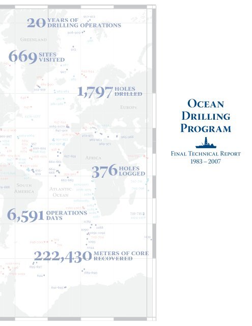
20910-912yearears ofdrilling operations908-909986Greenland6456466479881276-1277989-999 0914-919694982980-981987907Atlantic<strong>Ocean</strong>913642-6449851,797983-984637-6412-9061065-1070897-9019791-997 1063-1064976-979 972-9731054- 669-950-952963-9641062 670 957 953-956969-971395 920-924418 1074958648-64901671-676 1268-1275 657-659947- 1044-Africa949 1048660-661376002 1257-12612925- 664-7-678,896 930- 929 668 959-9621240946662-6639-688South1075-10771078-1079America1080176696,5911102-1101 31100101098-1099sitesvisiteited108810901091-1092703-704702698-7001093701222,4301094695-69722689-690holesdrilledEurope965-9689720-731707-711705-7061081-108310841262-1267 10851086732-7351087 1104-11061089operationsdays376 holes logged1139meters of corerecovered<strong>Ocean</strong><strong>Drilling</strong><strong>Program</strong><strong>Final</strong> <strong>Technical</strong> <strong>Report</strong>1983 – 2007691-693
<strong>Ocean</strong><strong>Drilling</strong><strong>Program</strong><strong>Final</strong> <strong>Technical</strong> <strong>Report</strong>1983 – 2007Consortium for <strong>Ocean</strong> Leadership, Inc.Lamont-Doherty Earth Observatoryof Columbia University<strong>Texas</strong> A&M UniversityNational Science FoundationContracts <strong>ODP</strong>83-17349 and OCE93-08410
Table of Contents6 Executive Summary8 <strong>Ocean</strong> <strong>Drilling</strong> <strong>Program</strong> Administration10 Scientific Results10 Engineering and Science Operations11 Samples, Data, and Publications13 Outreach14 <strong>Program</strong> Administration16 Administrative Structure19 Scientific Direction22 <strong>Program</strong> Management30 Scientific Results40 Engineering and Science Operations42 General Information43 <strong>Drilling</strong>, Coring, and Logging Statistics43 Operational and Laboratory Advancements49 Safety and Environment50 Documentation and Training52 Samples, Data, and Publications54 Core Curation and Repository Management54 Scientific Databases56 <strong>Report</strong>s and Publications58 Bibliographic Databases60 Out reach62 Outreach Activities64 Outreach Products
Executive Summary
<strong>ODP</strong> <strong>Final</strong> <strong>Technical</strong> <strong>Report</strong>The <strong>Ocean</strong> <strong>Drilling</strong> <strong>Program</strong> (<strong>ODP</strong>)operated successfully under NationalScience Foundation (NSF) Contracts<strong>ODP</strong>83-17349 (1 October 1983–30 September1993) and OCE93-08410 (1 October 1993–30September 2007). The <strong>ODP</strong> <strong>Final</strong> <strong>Technical</strong><strong>Report</strong> provides an overview of the managementand organization of <strong>ODP</strong> and highlights20 years of technical and scientific accomplishments.<strong>Ocean</strong> <strong>Drilling</strong> <strong>Program</strong>Administration<strong>ODP</strong> was the direct successor of the DeepSea <strong>Drilling</strong> Project (DSDP), which began in1968. DSDP sampled the global seafloor bydeep ocean coring and downhole logging, andits accomplishments were striking. Researchbased on the samples strongly supported thehypotheses of seafloor spreading—the relationshipof crustal age to the record of Earth’smagnetic reversals—and plate tectonics.<strong>ODP</strong> was an international partnership ofscientists and research institutions organizedto explore Earth’s history and structure asrecorded in the ocean basins. <strong>ODP</strong> providedsediment and rock samples (cores), downholegeophysical and geochemical measurements(logging), opportunities for special experimentsto determine in situ conditions beneaththe seafloor, and shipboard and shore-basedfacilities for the study of samples. <strong>ODP</strong> studiesled to a better understanding of plate tectonicprocesses, Earth’s crustal structure and composition,environmental conditions in ancientoceans, and climate change.<strong>ODP</strong> was funded by NSF and by internationalpartners, which during the course of the <strong>Program</strong>included the Australia/Canada/ChineseTaipei/Korea Consortium for <strong>Ocean</strong> <strong>Drilling</strong>,the European Science Foundation Consortiumfor <strong>Ocean</strong> <strong>Drilling</strong> (representing Belgium,Denmark, Finland, Greece, Iceland, Ireland,Italy, Norway, Portugal, Spain, Sweden, Switzerland,The Netherlands, and Turkey), France,Germany, Japan, the United Kingdom, Russia,and the People’s Republic of China. The<strong>ODP</strong> Council, representing all of the partners,provided a forum for exchange of views amongmember nations and reviewed financial,1984 1985a Sampling ofHistoric Eventsduring the<strong>Ocean</strong><strong>Drilling</strong><strong>Program</strong>Converted the oilexploration drillingvessel SEDCO/BP 471 forscientific ocean drilling.Leg 100, Gulf of Mexico:Initiated scientific drillingoperations and sailed thedrillship on its firstscientific expedition.Leg 105, Baffin Bay and Labrador Sea: Collectedalmost 1 mile of sediment and rock cores from as deepas 1,147 meters beneath the seafloor at the highest latitudeand in the deepest water ever drilled that far northby a scientific vessel.Leg 106, Mid-Atlantic Ridge: Collected first samplesever taken adjacent to Atlantic <strong>Ocean</strong> “black smokers.”
Executive Summarymanagerial, and other matters regarding theoverall support of <strong>ODP</strong>.Joint <strong>Ocean</strong>ographic Institutions, Inc. (JOI),now known as the Consortium for <strong>Ocean</strong>Leadership, Inc., provided central managementand, through subcontractors, the fullarray of services at sea and on land for <strong>ODP</strong>.<strong>Texas</strong> A&M University (TAMU) served asScience Operator, and the Borehole ResearchGroup (BRG) at Lamont-Doherty EarthObservatory (LDEO) of Columbia Universityprovided logging and other wireline services.LDEO also provided Site Survey Data Bankservices. JOI’s responsibilities as <strong>Program</strong>Manager also included management or supportof a number of <strong>Program</strong>-related activities,including the Joint <strong>Ocean</strong>ographic Institutionsfor Deep Earth Sampling (JOIDES) ScienceAdvisory Structure (SAS) for <strong>ODP</strong> through theJOIDES office. Additionally, under a separatecontract, JOI managed the U.S. ScienceSupport <strong>Program</strong> (USSSP), which supportedU.S. scientists’ participation in <strong>ODP</strong> and carriedout much of the <strong>Program</strong>’s educationaloutreach efforts (e.g., Distinguished LectureSeries, Schlanger Fellowships, etc.).Scientific direction for <strong>ODP</strong> was providedby JOIDES, an international organization ofadvisory committees and panels that providedplanning and program advice regardingscience goals and objectives, facilities, scientificpersonnel, and operating procedures.Long-range planning for the <strong>Program</strong> wasconducted utilizing reports generated fromthe 1981 and 1987 Conferences on Scientific<strong>Ocean</strong> <strong>Drilling</strong> (COSOD) and 1993 U.S. Committeeon Post-1998 <strong>Ocean</strong> <strong>Drilling</strong> (COM-POST) meeting, 1990 and 1996 <strong>ODP</strong> LongRange Plans, 65 Predrilling Workshops heldbetween 1985 and 2003, and recommendationsthat were provided every 3–5 years by apanel of experts called the Performance EvaluationCommittee (PEC).“<strong>ODP</strong> was an internationalpartnership… organized to exploreEarth’s history and structureas recorded in the ocean basins.”Scientists representing the <strong>ODP</strong> partnersreviewed drilling proposals and participated ineach <strong>ODP</strong> research cruise. This unique formatbrought together researchers from universities,industry, and government laboratories inthe member nations to work in a state-of-theartshipboard laboratory on focused scientific1986 19871989Leg 108, Eastern TropicalAtlantic: Documenteda shift to drier climatein Central East Africathought to have been theimpetus for human migrationfrom Africa starting2 million years ago.Leg 113, Weddell Sea:Cored southernmost siteat 70.8°S and documentedthe establishment of apermanent West Antarcticice sheet at ~5 Ma.Leg 115, MascarenePlateau: Recovered firstevidence of long-livedhotspot tracks.Leg 116, Distal BengalFan: Established thehypothesis that uplift ofthe Himalayas enhancedglobal cooling.Leg 128, Japan Sea:Installed the first longtermocean-bottomseismometer in one of theworld’s most activeearthquake zones, offwestern Japan.
<strong>ODP</strong> <strong>Final</strong> <strong>Technical</strong> <strong>Report</strong>goals. Students also participated in drillingcruises, working with some of the world’s leadingscientists and becoming part of the intellectualfabric essential for future advances inthe earth sciences.Scientific ResultsScientific ocean drilling has made fundamentalcontributions to our understanding of theEarth. For instance, we now know that theparadigm of plate tectonics offers tremendousnew insights into the way Earth works,including a better understanding of naturalhazards such as earthquakes and volcanoes.Studies of marine sediments have resulted in amuch better understanding of natural climaticvariability, and we are beginning to learn howto factor global change into planning for thefuture. Evidence was found during scientificocean drilling cruises for present-day formationof huge ore-grade deposits of iron, copper,and zinc precipitated out of hydrothermalfluids heated to more than 300°C and rising ashot springs from the center of spreading ridgesas well as evidence for large amounts of lessheatedwater percolating through the ridgeflanks, which has implications for the recyclingof ocean water through the crust. Earth waseven more thermally active during the Cretaceous,when enormous plumes of mantle rockrose beneath the lithosphere and triggered theformation of individual volcanoes and volcanicplateaus at rates unknown in today’s world. Wehave confirmed that large volumes of naturalgas (methane) are frozen within deep-seamarine sediments as gas hydrates, and wehave produced quantitative measurementsof the amount of inert gas hydrate and gasoffshore South Carolina. From our results, italso appears that the oceanic crust is home toan unforeseen microbial community called thedeep biosphere, whose concentration is smallbut, because oceanic crust is the most abundantrock sequence on Earth, may contain asignificant fraction of Earth’s biomass.Engineering and ScienceOperationsWith the combination of a unique researchvessel, dedicated staff at <strong>ODP</strong>-supported institutions,and scientific participants worldwide,19891991 1993Leg 129, Mariana Basin: Drilledin deepest water depth (5,980meters) and recovered the oldestremaining remnants of the Pacific<strong>Ocean</strong>’s original seafloor—175-million-year-old fragments ofsediments and ocean crust fromthe Jurassic period (~170 Ma).Leg 139, Middle Valley and Juan de Fuca Ridge:Recovered hydrothermal metal deposits and installedthe first of many long-term geochemical observatoriesusing an instrumented borehole seal called thecirculation obviation retrofit kit (CORK).Leg 140, Costa Rica Rift:Penetrated into pillow lavasand sheeted dikes, anddocumented that the Layer2C/Layer 3 boundary (which isseismic in character) could becaused by a velocity gradientand not a lithologic boundary.Leg 148, Costa RicaRift: Drilled deepesthole (2,111 meters) inthe ocean’s crust.10
Executive Summary<strong>ODP</strong> conducted cutting-edge exploration fromJanuary 1985 through September 2003. Duringthis time, more than 2,600 internationalscientists sailed on more than 110 cruises onboard the JOIDES Resolution, a 469-foot-longand 68.9-foot-wide research vessel namedafter James Cook’s flagship of two centuriesago, the HMS Resolution.<strong>ODP</strong> often drilled into environments of enormouspressure, elevated temperatures, andchemical toxicity. Scientific advancements inthese environments were made possible bybreakthroughs in <strong>ODP</strong> technology, includingthe development of many drilling tools andtechniques, as <strong>ODP</strong> was the first organizationto drill into such deepwater and hostileenvironments. Additionally, developments insediment analysis, analytical instruments, agemodels, seafloor observatories, and measurementof in situ conditions along with softwaredevelopment and joint ventures enteredinto by <strong>ODP</strong> in conjunction with industrialpartners helped advance our understandingof Earth’s structure and evolution.Samples, Data,and PublicationsEach recovered core provides unique andvaluable information regarding Earth’s historyand processes. Samples of subseafloorsediments and rocks collected during <strong>ODP</strong>are indispensable to scientists expandingmankind’s knowledge of environmentalchange, earthquake genesis, volcanic processes,evolution of life, and other scientificquestions.Cores collected during the <strong>Program</strong> werestored at shore-based core repositories inthe United States (<strong>Texas</strong> A&M University,Scripps Institution of <strong>Ocean</strong>ography, andLamont-Doherty Earth Observatory ofColumbia University) and Germany (Universityof Bremen), providing the internationalscientific community with access to thecore collection as well as sediment and rocksamples for further research. Additionally,micropaleontological reference centers establishedon four continents and hosted by morethan a dozen major institutions around the19941995 19971998Leg 156, BarbadosAccretionary Prism: Firstsuccessful penetration ofthe décollement fault andfirst use of logging-whiledrilling(LWD) tools.Leg 164, Blake Ridge:Sailed inaugural gashydrate expedition inthe Atlantic <strong>Ocean</strong> andconfirmed that significantamount of gas deposits arecontained in oceansediments.Leg 171B, Blake Nose Paleoceanographic Transect:Confirmed the catastrophic impact of a meteorite withEarth 65 million years ago that led to the extinction ofdinosaurs and other plants and animals at the end of theCretaceous period.Leg 175, Benguela Current: Recovered the most core(8,003 meters) collected during a single expedition.Leg 180, Woodlark Basin:Discovered microbes livingin sediments 800 metersbeneath the seafloor.11
<strong>ODP</strong> <strong>Final</strong> <strong>Technical</strong> <strong>Report</strong>world provided scientists the opportunity toexamine, describe, and photograph microfossilsof various geological ages and provenance(iodp.tamu.edu/curation/mrc/institutions.html).The Initial <strong>Report</strong>s and Scientific Results volumesof the Proceedings of the <strong>Ocean</strong> <strong>Drilling</strong><strong>Program</strong> were published to summarize thescientific and/or technical accomplishmentsof each cruise. This publication series includespredrilling geological and geophysical site surveys,leg objectives, planning documentation,core records, physical and geochemical measurements,logging data, core photographs,paleontology and petrological reports, scientificresearch results, and syntheses. Near theconclusion of the <strong>Program</strong>, all <strong>ODP</strong> printedpublications were digitized and made availableonline (www.odplegacy.org/samples_data/publications.html).The results of research based on <strong>ODP</strong> datahave been published openly in leading scientificjournals as well as in the Proceedings ofthe <strong>Ocean</strong> <strong>Drilling</strong> <strong>Program</strong>. The <strong>Ocean</strong> <strong>Drilling</strong>Citation Database (iodp.tamu.edu/publications/citations/database.html) servesas a comprehensive reference to all scientificdrilling publications. Covering researchspanning from 1969 to the present, it containsmore than 22,500 citations related tothe <strong>Ocean</strong> <strong>Drilling</strong> <strong>Program</strong> and its relatedprograms DSDP and the Integrated <strong>Ocean</strong><strong>Drilling</strong> <strong>Program</strong> (I<strong>ODP</strong>). Two volumes ofabstract collections, <strong>ODP</strong>’s Greatest Hits,published in November 1997, and <strong>ODP</strong> Highlights,published in December 2004, illustratethe rich diversity of the international scientificcommunity’s accomplishments through<strong>ODP</strong> (www.odplegacy.org/science_results/highlights.html).<strong>ODP</strong> scientific data are housed in databasesthat are accessible online, allowingeasy retrieval for users worldwide. The coredata, which are housed in a relational databasecalled Janus, are available at iodp.tamu.edu/database/index.html and are also archivedby the National Geophysical Data Center inBoulder, Colorado. Janus contains 450 tablesof <strong>ODP</strong>’s marine geoscience data that werecollected on board the drillship JOIDES Resolution,including paleontological, lithostrati-1999 2000 2001Completed major modificationsto the ship’s capabilitiesduring dry dock,including upgrades of thescience infrastructure andinstallation of a permanentmicrobiology laboratory.Leg 186, Western Pacific:Using the longest casingstring yet suspendedfrom a deep-sea drillship,installed long-term oceanbottomseismometers andstrain meters in two holesoff Japan.Leg 189, TasmanianGateway: Confirmed theformation of the AntarcticCircumpolar Current33 million years agoand subsequent climaticcooling that ended the“hothouse” era.Leg 193, Manus Basin:Obtained results from apotential deep-sea minefor metallic resources thatled to the development ofnew guidelines for futureland-based mineralexploration.Legs 198 and 199,central Pacific <strong>Ocean</strong>:Documented abruptclimate change during thePaleocene/EoceneThermal Maximum(PETM).12
Executive Summarygraphic, chemical, physical, sedimentological,and geophysical data for ocean sedimentsand hard rocks. Logging data are available atiodp.ldeo.columbia.edu/DATA. The log databasecontains standard downhole logs (e.g.,geophysical data and resistivity images), logsfrom specialty tools (e.g., borehole televiewer,geochemical, multichannel sonic, loggingwhile-drilling[LWD], and temperature tools),and processed and original wireline and LWDdata for DSDP and <strong>ODP</strong>.OutreachWorking within a limited budget, <strong>Program</strong>staff raised <strong>ODP</strong> visibility and informed thescientific community and general publicof important discoveries that heightenedunderstanding of Earth’s history and scientificocean drilling. This was accomplishedthrough a variety of creative outreach activitiesand products, including documentaries,newspaper and magazine articles, pressreleases, exhibit booths at science conferences,and port call events. Public relationsand outreach products and activities for <strong>ODP</strong>are documented on the <strong>ODP</strong> Legacy Web site(www.odplegacy.org/outreach).The <strong>ODP</strong> Legacy Web site (www.odplegacy.org) was launched in September 2006 in recognitionof the importance of preserving andcompiling the scientific, technological, andexperiential legacy of <strong>ODP</strong>. This Web site wasdeveloped to encourage interest, awareness,and understanding of <strong>ODP</strong> as a program; preservethe data, documents, and publicationsproduced during the <strong>Program</strong>; and highlightthe scientific and technical accomplishmentsof the <strong>Program</strong>. Users can access scientificdata generated during operations on boardthe JOIDES Resolution and later shore-basedactivities via various links to on the Website. Although the site is not intended as acomprehensive historical archive, it containsdownloadable documents that cover a widespectrum of <strong>Program</strong> information, from laboratoryand instrument manuals to all of the<strong>Program</strong>’s scientific publications, journals,and educational materials. The <strong>ODP</strong> LegacyWeb site also includes some data and publicationsrelated to DSDP, the ground-breakingprecursor to <strong>ODP</strong>.2002 2003Leg 201, EasternEquatorial Pacific andPeru Margin: Discoveredevidence of vast, activedeep biosphere in oceansediments and crust.Leg 204, Hydrate Ridge:Multiple gas hydratecores recovered under insitu pressure, first use ofLWD tools for gas hydratestudies.Legs 207 and 208, Demerara Rise and Walvis Ridge:Recovered samples from the Cretaceous/Paleogene(K/P) boundary and the PETM that provided evidence ofrapid global climate and ocean circulation changes thatled to periods of plant and animal mass extinctions.Leg 210, NewfoundlandMargin: Concluded <strong>ODP</strong>operations and begandemobilization of theJOIDES Resolution inGalveston, <strong>Texas</strong>.13
<strong>ODP</strong> <strong>Final</strong> <strong>Technical</strong> <strong>Report</strong>
<strong>Program</strong> Administration
<strong>ODP</strong> <strong>Final</strong> <strong>Technical</strong> <strong>Report</strong>Administrative StructureThe <strong>Ocean</strong> <strong>Drilling</strong> <strong>Program</strong> (<strong>ODP</strong>) wasfunded by the U.S. National ScienceFoundation (NSF) and 22 internationalpartners (as of 2003) and was directedby Joint <strong>Ocean</strong>ographic Institutions for DeepEarth Sampling (JOIDES), an internationalcommunity of scientists from <strong>ODP</strong>’s membercountries who served on advisory committeesand panels to provide planning and programadvice regarding science goals and objectives,facilities, scientific personnel, and operatingprocedures.The <strong>ODP</strong> office at NSF was responsible foroverseeing the <strong>Program</strong> and administeringcommingled funds from the internationalpartners. The <strong>ODP</strong> Council, representing allof the partners, provided a forum for exchangeof views among member nations and reviewedfinancial, managerial, and other mattersregarding the overall support of <strong>ODP</strong>.Joint <strong>Ocean</strong>ographic Institutions, Inc. (JOI),served as the <strong>Program</strong> Manager, providingcentral management and, through subcontractors,the full array of services at sea and onland for <strong>ODP</strong>.<strong>ODP</strong> Member Countries1985198619871988198919901991199219931994199519961997199819992000200120022003AustraliaBelgiumCanadaChinese TaipeiDenmarkFinlandFranceGermanyGreeceIcelandIrelandItalyJapanKoreaNorwayPeople’s Republic of ChinaPortugalRussiaSpainSwedenSwitzerlandThe NetherlandsTurkeyUnited KingdomUnited StatesTotal Countries per Year 4 6 18 19 19 19 20 20 19 19 20 22 21 21 22 22 22 22 2216
<strong>Program</strong> Administration<strong>Ocean</strong> <strong>Drilling</strong> <strong>Program</strong> Organizational StructureInternationalPartnersNationalScienceFoundationJoint<strong>Ocean</strong>ographicInstitutions,Inc.Joint <strong>Ocean</strong>ographic Institutionsfor Deep Earth SamplingScience Advisory Structure<strong>Texas</strong> A&MResearch FoundationShip Operationsand Science ServicesLamont-Doherty Earth Observatoryof Columbia UniversityWireline Servicesand Data BankContract and SubcontractStructure and RolesPrime Contractor (<strong>Program</strong> Manager)JOI, a nonprofit (501[c]3) oceanographic organization,was formed in 1976 by the U.S. memberinstitutions of JOIDES to facilitate scientificocean drilling and advance oceanographicresearch in general and to provide overallmanagement as the prime contractor to NSF.JOI was the prime contractor for <strong>ODP</strong> fromits inception in 1983. JOI’s responsibilities as<strong>Program</strong> Manager also included managementor support of a number of <strong>Program</strong>-relatedactivities, including the JOIDES ScienceAdvisory Structure (SAS) for <strong>ODP</strong> through theJOIDES office.Additionally, under a separate contract, JOImanaged the U.S. Science Support <strong>Program</strong>(USSSP), which supported United Statesscientists’ participation in <strong>ODP</strong> and carriedout much of the <strong>Program</strong>’s education/outreachwork, such as the Distinguished Lecture Seriesand the Schlanger Fellowships.SubcontractorsJOI established subcontracts with <strong>Texas</strong> A&MUniversity (TAMU) through the <strong>Texas</strong> A&MResearch Foundation (TAMRF) to serve asScience Operator and with the BoreholeResearch Group (BRG) at Lamont-DohertyEarth Observatory (LDEO) of Columbia Universityto serve as Wireline Services Operatorand provide logging and other wireline services.LDEO also provided Site Survey DataBank (SSDB) services. Through a subcontractto the JOIDES office, JOI provided support forJOIDES activities.“The <strong>Ocean</strong> <strong>Drilling</strong> <strong>Program</strong>was funded by theU.S. National Science Foundationand 22 international partners… .”<strong>ODP</strong>-TAMU and <strong>ODP</strong>-LDEO provided scientificand operational technical, engineering,and logging support and innovation involvingclose collaboration and subcontracts withindustry (e.g., active heave compensation, riginstrumentation system [RIS]), successfullymanaging a variety of long- and short-termsubcontracts, including Overseas <strong>Drilling</strong> Limited(ODL) for the lease of the JOIDES Resolutionand Schlumberger for logging services.In addition, <strong>ODP</strong> engaged in two-way collaborativerelationships with offshore oil andgas industrial and service groups supportingscientific drilling research and developmentcontracts in support of science drilling (e.g.,hammer drill-in casing) and technology trans-17
<strong>ODP</strong> <strong>Final</strong> <strong>Technical</strong> <strong>Report</strong>fer from scientific drilling to the industrialsector (e.g., Fugro hydraulic piston corer).Science OperatorThe Science Operator, <strong>ODP</strong>-TAMU, wasresponsible for operation of the JOIDESResolution and associated activities of cruisestaffing; logistics; engineering development;operations; shipboard laboratories; acquisition,curation, and distribution of core samplesand data; publication of scientific results; andassistance with <strong>ODP</strong> public relations. Onboard the ship, <strong>ODP</strong>-TAMU maintained thelaboratories and provided technical and logisticalsupport for shipboard scientific teams.On shore, <strong>ODP</strong>-TAMU managed scientific anddrilling activities before and after each cruise,curated the cores, distributed samples, editedand published scientific results, archived coredata, provided data distribution services, andprovided administrative and logistical supportfor all these activities. <strong>ODP</strong>-TAMU also performedcore data verification and processedrequests from the scientific community forcore data and photos.Wireline Services OperatorAs Wireline Services Operator, <strong>ODP</strong>-LDEOprovided state-of-the-art downhole loggingcapabilities customized to scientists’ needs.This involved acquiring, processing, andpresenting in situ logging measurements inusable scientific form; shipboard supervisionof Schlumberger logging activities; and managementof shipboard and shore-based loginterpretation centers. <strong>ODP</strong>-LDEO provideddata analysis and distribution services to assistscientists using these logs to solve particularscientific problems. <strong>ODP</strong>-LDEO also providedtechnical and logistical support for provisionof third-party wireline logging tools, developmentof log interpretation software, andengineering developments for new downholemeasurements.Site Survey Data BankThe <strong>ODP</strong> SSDB was located at LDEO, whereit housed regional geophysical and site surveydata submitted in support of proposed drillingprograms. The SSDB assisted in the planningand development of <strong>ODP</strong> programs bycompiling packages of available data for each<strong>ODP</strong> proposal for review by various JOIDESadvisory panels, supplying each shipboard scientificparty with the geophysical data necessaryfor proper conduct of scheduled drillingcruises, and assisting drilling proponents inthe development of data packages and sitesurveys in support of their proposals.Throughout <strong>ODP</strong>, the SSDB compiled anextensive collection of geophysical data foruse in support of scientific ocean drilling. The18
<strong>Program</strong> Administration(www.odplegacy.org/program_admin/joides_journal.html) to keep the scientific communityinformed of planning for the drilling programand to summarize <strong>Program</strong> activities.Scientific DirectionSSDB also developed visualization tools toassist in management and review of data duringthe transition from paper submissions toelectronic data submissions. The data archiveand management tools were transferred to theI<strong>ODP</strong> SSDB.JOIDES OfficeThe JOIDES office, under the direction of theChair of the JOIDES Scientific Committee(SCICOM), was responsible for coordinatingall the advisory committees and panels withinthe JOIDES SAS. This office also integratedadvice from the panel substructure in a mannersuitable for policy decisions by the JOIDESExecutive Committee (EXCOM). The JOIDESOffice also produced the JOIDES JournalJOIDES Science Advisory StructureThe JOIDES SAS was restructured in 1996to better undertake the initiatives and objectivescontained in the 1996 long-range plan,“Understanding our Dynamic Earth through<strong>Ocean</strong> <strong>Drilling</strong>” (www.odplegacy.org/PDF/Admin/Long_Range/<strong>ODP</strong>_LRP_1996.pdf).The SAS structure as of 2003, at the end of<strong>ODP</strong> operations, is discussed below.JOIDES was responsible for establishing scientificobjectives for <strong>ODP</strong> legs through the SASthat involved more than 100 scientists andengineers on standing committees and panelsand almost 100 in the shorter-lived planninggroups. Each committee, panel, planninggroup, and working group operated undera mandate and with guidelines on membershipand frequency of meetings. In additionto SCICOM and EXCOM, the JOIDES SASconsisted of the following groups:JOIDES Science Advisory Structure(as of 2003)Executive Committee(EXCOM)BudgetCommittee(BCOM)Science Committee(SCICOM)Operations Committee(OPCOM)Science Steering andEvaluation Panel—Earth’s Environment(ESSEP)Science Steering andEvaluation Panel—Earth’s Interior(ISSEP)<strong>Technical</strong> & EngineeringDevelopment Committee(TEDCOM)<strong>Program</strong> andDetailedPlanning Groups(PPGs and DPGs)Site SurveyPanel(SSP)PollutionPrevention andSafety Panel(PPSP)ScientificMeasurementsPanel(SciMP)19
<strong>ODP</strong> <strong>Final</strong> <strong>Technical</strong> <strong>Report</strong>• The Budget Committee (BCOM), asubcommittee of EXCOM, which wasresponsible for overseeing and reviewing<strong>ODP</strong> <strong>Program</strong> Plans and budgets.• The Operations Committee (OPCOM),created as a subcommittee of SCICOM,which dealt with operational issues, such asship scheduling, technological development,and scientific measurements.• Two Science Steering and EvaluationPanels (SSEPs)—the Dynamics of Earth’sEnvironment SSEP and the Dynamics ofEarth’s Interior SSEP—which providedSCICOM with evaluations of high-prioritydrilling proposals and advice on longertermthematic development.• The Site Survey Panel (SSP), whichassessed the adequacy of survey data forproposed drilling targets and assistedin the international coordination andimplementation of additional site surveys.• The Pollution Prevention and Safety Panel(PPSP), which gave independent advice toOPCOM and to <strong>ODP</strong> on potential safetyand pollution hazards that might existbecause of general and specific geologiccircumstances of proposed drill sites andadvised proponents and Co-Chief Scientistson safe site selection.• The Scientific Measurements Panel(SciMP), which contributed informationand advice on handling of <strong>ODP</strong> samplesand data and on methods and techniquesused for all shipboard and downholemeasurements and experiments.• The Technology and EngineeringDevelopment Committee (TEDCOM),which provided long-term technologicaladvice to SCICOM and OPCOM ondrilling tools and techniques required tomeet the objectives of planned drill holes,provided a forum for the exchange ofideas and information between <strong>ODP</strong> andthe commercial drilling industry, and also<strong>Drilling</strong>VerticalDisplacement (bottom)Heave (surface)JOI DESJournalJoint <strong>Ocean</strong>ographic Institutions for Deep Earth SamplingHeave Compensator stopsVol. 26 No. 2-2000Preliminary Results fromLeg 188 <strong>Drilling</strong> in PrydzBay AntarcticaThe Opening of the TasmanianGateway: Results ofLeg 189Deformation and FluidFlow Processes:<strong>ODP</strong> Leg 190Ship Heave Effects:Observations from Legs185 and 188Core-Log Integration PlatformUpdate (SAGAN)Excerpts from the <strong>Final</strong><strong>Report</strong> of JOIDES GasHydrate <strong>Program</strong>Planning Groupidentified and monitored the developmentof drilling tools and techniques needed tomeet the objectives of the long-range plan.• Ad hoc Detailed Planning Groups (DPGs),which were short-lived groups formed bySCICOM that met only once or twice formore intensive study of certain aspects ofplanning.• <strong>Program</strong> Planning Groups (PPGs), whichdeveloped plans to address new <strong>ODP</strong>initiatives or to define new technologicalstrategies and played a vital role inpromoting high-priority scientific objectivesin areas where proposals were lackingand in fostering communication andcollaboration between <strong>ODP</strong> and otherinternational geoscience programs.• Working Groups, which were short-livedgroups formed by SCICOM with thepurpose of taking ideas originating fromworkshops or topics discussed at SAS panelmeetings and developing possible models/strategies and recommendations for theassigned topic.Mandates for these groups and minutes formeetings of many of these groups are availableon the <strong>ODP</strong> Legacy Web site (www.odplegacy.org/program_admin/sas.html).20
<strong>Program</strong> AdministrationJOIDES JournalThroughout <strong>ODP</strong>, the JOIDES Journal servedas a means of communication among the JOI-DES committees and advisory panels, NSF andnon-U.S. participating organizations, JOI andits subcontractors, and interested earth scientists.The JOIDES Journal provided informationon JOIDES committees and panels, cruiseschedules, science summaries, and meetingschedules. The <strong>ODP</strong> Legacy Web site includeslinks to JOIDES Journal issues 1 through 30(1975–2004) (www.odplegacy.org/program_admin/joides_journal.html).Long-Range PlanningThe report from the first Conference on Scientific<strong>Ocean</strong> <strong>Drilling</strong> (COSOD), held in November1981, documented the scientific basis andjustification for <strong>ODP</strong>. This report identified12 major scientific themes for which JOIDESdeveloped specific drilling plans. The report ofthe second COSOD meeting, held in July 1987,provided the framework for scientific oceandrilling through the 1990s.The <strong>ODP</strong> Long Range Plan (published in 1990)distilled the COSOD themes, JOIDES panelwhite papers, and other scientific and technicaladvice into a scientific and engineeringstrategy from 1990 through 2002. A reportfrom the October 1993 U.S. Committee onPost-1998 <strong>Ocean</strong> <strong>Drilling</strong> (COMPOST) meetingidentified the needs of the U.S. scientificcommunity for ocean drilling in the post-1998time frame and related facility requirements.This report resulted in a second <strong>ODP</strong> LongRange Plan, published in 1996, that updatedand extended the 1990 Long Range Plan(www.odplegacy.org/program_admin/long_range.html).Predrilling WorkshopsPredrilling Workshops provided opportunitiesfor members of the scientific community toevaluate the current state of knowledge concerninga particular topic, or field of research,and discuss ways in which scientific oceandrilling could advance knowledge in that area.Workshop topics were selected on the basis ofunsolicited proposals submitted by individualswilling to undertake the task of locating asuitable venue and organizing the proposedworkshop. Participation was open to any interestedmember of the scientific community.A limited number of essential participants ateach workshop received travel funds to supporttheir participation. Financial support forthe workshops was provided by USSSP, oftenin collaboration with other national or internationalfunding agencies.Following each workshop, the organizers wererequired to prepare a written report of the proceedingsand recommendations of the workshopand were encouraged to publish a briefsummary of their report for wider circulation.Workshop reports often formed the basisfor specific drilling proposals subsequentlysubmitted for consideration by the SAS. The<strong>ODP</strong> Legacy Web site includes a listing of allPredrilling Workshops held between June 1985and July 2003 and links to reports from mostof these workshops (www.odplegacy.org/program_admin/workshops.html).21
<strong>ODP</strong> <strong>Final</strong> <strong>Technical</strong> <strong>Report</strong><strong>Program</strong> EvaluationBeginning in 1985, <strong>ODP</strong> was evaluated every3–5 years by a panel of experts, the PerformanceEvaluation Committee (PEC), andrecommendations were disseminated in theirreports (www.odplegacy.org/program_admin/evaluation.html). Committee members wereappointed by JOI on the advice of JOIDES,NSF, and other experts in geology, geophysics,ocean drilling, and logging technology.PEC evaluations provided valuable feedbackregarding the effectiveness of JOI programmanagement and the performance of<strong>ODP</strong>-TAMU and <strong>ODP</strong>-LDEO and indicatedwhether the program was meeting its scientificgoals. The evaluations also produceddata or verified results that could be used forpublic relations and <strong>ODP</strong> promotion in thecommunity. Recommendations and informationobtained from PEC evaluations were notonly used to improve <strong>ODP</strong> during the life ofthe <strong>Program</strong> but also served to determinewhat lessons were learned and what modifications(e.g., legacy preservation, overarchingeducation and outreach plans, etc.) should beaddressed for I<strong>ODP</strong>, the successor program to<strong>ODP</strong>.<strong>Program</strong> Management<strong>ODP</strong> Policy Manual<strong>ODP</strong> was managed and operated under policiesand guidelines outlined in the <strong>ODP</strong> PolicyManual. The last revision of the manual (2003)is available on the <strong>ODP</strong> Legacy Web site(www.odplegacy.org/program_admin/policies.html).<strong>Program</strong> Plans<strong>ODP</strong> work was carried out in accordancewith annual and multiyear <strong>Program</strong> Plansdeveloped by JOI, <strong>ODP</strong>-TAMU, and <strong>ODP</strong>-LDEO in consultation with the NSF <strong>Program</strong>Officer and approved in writing by the NSFContracting Officer. <strong>Program</strong> Plans addressedprogrammatic goals; scheduled activities;scheduled ship operations, staffing, and organizationalplans; budgets; scientific objectivesdefined by JOIDES; and major planning andreview activities. Preparations for each annual<strong>Program</strong> Plan started a year in advance; theprogram plan was submitted to NSF a fewmonths before the start of the fiscal year.Leg PlanningAfter the SAS accepted a scientific oceandrilling proposal for incorporation into thedrilling schedule, substantial preparationswere required to ensure successful executionof the proposed program (www.odplegacy.org/program_admin/leg_planning.html).Some programs required multiple cruises forcompletion of the scientific objectives. Eachindividual cruise was referred to as a “leg” andhad its own technical crew and shipboard scientificparty. Leg planning was a collaborativeeffort involving the Science Operator, WirelineServices Operator, Co-Chief Scientists,and <strong>Drilling</strong> Contractor. The major tasks thathad to be accomplished before the JOIDESResolution sailed and the time frame duringwhich these tasks had to be accomplished aredescribed below. The detail, complexity, andlevel of effort required to plan a leg variedsignificantly depending on the location andthe scientific and operational complexity of theproposed program.12–18 Months PrecruiseWith input from the Science and Wireline ServicesOperators, OPCOM developed the shipschedule at least a year in advance. The schedulewas constructed from the list of proposalsapproved for future ocean drilling, taking intoaccount any priorities established by JOIDES.The Science Operator provided OPCOM withestimates of the ship time required for eachproposal and identified operational issues22
<strong>Program</strong> Administration(both engineering and weather) and possibleport calls. The ship schedule was thenconstructed to maximize on-site time andminimize travel time between sites or to andfrom port. Proposals that did not require a full2-month <strong>ODP</strong> leg were combined to maximizeefficient use of ship time and to allow the<strong>Drilling</strong> Contractor to maintain a regular crewrotation.9–12 Months PrecruiseSpecial engineering/equipment needs andclearance requirements for operations innational waters of non-U.S. coastal states wereidentified. A detailed operations schedule wasprepared, refining the preliminary time andmaterial estimates in accordance with morespecific plans for the leg.Co-Chief Scientists were selected by theScience Operator from a list of individualsnominated by <strong>ODP</strong> member countries. TheCo-Chief Scientist Agreement outlined theirresponsibilities and represented a contractbetween the Co-Chief Scientist and <strong>ODP</strong>(see “Appendix Q” of the <strong>ODP</strong> Policy Manual[www.odplegacy.org/program_admin/policies.html]). By accepting an invitation, Co-ChiefScientists acknowledged their responsibilitiesand obligations to the <strong>Program</strong>.The following key operator personnel werealso designated:<strong>ODP</strong> Co-Chief Scientists fromMember Countries or ConsortiaUnited StatesGermanyESFJapanUnited KingdomPacRimFranceRussiaPR China11Nonmembers 00181818181619of the shipboard scientific party to ensurethat the proposed shipboard work wasaccomplished in a timely manner, scientificobjectives were met, and cruise results weredocumented in the appropriate reports andpublications postcruise.• The Operations Manager, an engineeron the staff of the Science Operator, wasresponsible for planning and overseeingall operational aspects of the leg. At sea,the Operations Manager oversaw the workof the <strong>Drilling</strong> Contractor and served asliaison between the Co-Chief Scientistsand the drilling crew. The OperationsManager served as the Science Operator’srepresentative on board the ship for11120 40 60 80 100 120Number• The Leg Project Manager/Staff Scientist,a scientist on the staff of the ScienceOperator, was responsible for overseeingand coordinating all precruise preparations.This included coordinating drilling,logging, and science plans with the Co-Chief Scientists and other Science andWireline Operator staff and maintainingregular communication with the membersof the shipboard scientific party to keepthem apprised of progress and remindthem of preparations for which theywere responsible (e.g., submitting samplerequests, making travel arrangements, etc.)The Leg Project Manager then sailed on theleg as Staff Scientist, coordinating the efforts23
<strong>ODP</strong> <strong>Final</strong> <strong>Technical</strong> <strong>Report</strong>contractual matters relating to the <strong>Drilling</strong>Contractor’s services.• The Logging Staff Scientist, a member ofthe Wireline Services Operator staff, wasresponsible for planning the wireline andlogging-while-drilling program for theleg. At sea, the Logging Staff Scientist wasresponsible for the execution of the loggingprogram, including preliminary processingof logging results and production oflogging-related reports in a timely mannerand for contributing as a member of theshipboard scientific party.• The Laboratory Officer, a member of theScience Operator staff, led the shipboardtechnical support staff and was responsiblefor all aspects of shipboard laboratoryoperations, including safety.Co-Chief Scientists worked with the SSDB todevelop a safety report for proposed drill sites.These reports were presented with supportinggeophysical data to the PPSP at biannual meetings.Sites posing no hazard were approved fordrilling. For sites posing potential hazards, thePPSP worked with the Co-Chief Scientists tofind acceptable alternate sites that still met theleg’s scientific objectives.6–9 Months PrecruiseA Precruise Meeting, led by the Leg ProjectManager, was held for Co-Chief Scientists and<strong>ODP</strong> Scientists fromMember Countries or ConsortiaUnited StatesGermanyESFJapanUnited KingdomPacRimFranceRussiaPR ChinaNonmembers017852187242240232232210200 400 600 800 1,000 1,200 1,400Number1,210key personnel. The objectives of the meetingincluded the following:• Acquaint Co-Chief Scientists with key<strong>ODP</strong> staff involved in cruise planning andexecution.• <strong>Final</strong>ize operational plan and requirements.• Familiarize Co-Chief Scientists with <strong>ODP</strong>policies and procedures.• Select shipboard scientific party members.Each <strong>ODP</strong> leg had a shipboard scientificparty of approximately 24 scientists, inaddition to the Co-Chief Scientists, StaffScientist, and Logging Staff Scientist.Shipboard scientific party members wereselected by the Science Operator, inconsultation with the Co-Chief Scientists,from lists of individuals nominated by <strong>ODP</strong><strong>ODP</strong> Scientists fromEuropean Science Foundation ConsortiumItalyNorwaySwedenDenmarkSwitzerlandSpainThe NetherlandsBelgiumFinlandPortugalTurkeyGreeceIcelandIrelandCanadaAustraliaChinese TaipeiKorea011135461517253030406210 20 30 40 50 60 70Number<strong>ODP</strong> Scientists fromPacific Rim Consortium07106612720 40 60 80 100 120 140Number24
<strong>Program</strong> Administrationmember countries. The selection processtook into account the expertise required toconduct the scientific program of the legand the requirement to maintain a balanceof representation from the different <strong>ODP</strong>members.<strong>ODP</strong> Scientists fromNonmember CountriesAngolaBrazilChileColombiaCosta RicaEquadorFijiGhanaHondurasIndiaIsraelMexicoNew CaledoniaNew ZealandPanamaPapua New GuineaPeruPhilippinesPuerto RicoSingaporeSouth AfricaSri LankaSultanate of OmanTongaVenezuela011111111111222222222231 2 3 4 5 6 7Number666• Complete the Scientific Prospectus, whichlaid out the scientific and operational planfor the leg (www.odplegacy.org/samples_data/publications.html). In addition toproviding information for prospectiveleg participants and others involved in<strong>ODP</strong>, the Scientific Prospectus formedthe basis for the leg operational plan andfuture associated leg-related decisions andprovided essential information for anynecessary foreign clearance requests. Anydeparture from the plans set forth in theScientific Prospectus required approvalfrom the Science Operator and JOIDES.Changes to logging plans required approvalfrom the Wireline Services Operator.After the Precruise Meeting, applications weremade, via the U.S. Department of State, forforeign clearances (if needed), and invitationswere issued to prospective shipboard scientificparty members that outlined the shipboardand postcruise tasks to be performed(see “Appendix R” of the <strong>ODP</strong> Policy Manual25
<strong>ODP</strong> <strong>Final</strong> <strong>Technical</strong> <strong>Report</strong>[www.odplegacy.org/program_admin/policies.html]). In accepting an invitation, scientistsacknowledged their responsibilities and obligationsto the <strong>Program</strong>.3–6 Months PrecruiseMembers of the shipboard scientific partysubmitted requests for samples necessary forthem to carry out their work for the leg, andthe sample requests were collated by the <strong>ODP</strong>Curator into an initial sampling plan. Conflictsresulting from duplication of requestsor requests for excessive numbers of sampleswere resolved prior to the leg by the SampleAllocation Committee (SAC), which consistedof the Leg Project Manager, Co-Chief Scientists,and <strong>ODP</strong> Curator (see “Appendix D”of the <strong>ODP</strong> Policy Manual [www.odplegacy.org/program_admin/policies.html]). At sea,the Shipboard Curator replaced the Curator asa member of the SAC. With SAC approval, thesampling plan was often modified while theship was at sea in response to the amount andtype of core material recovered.Also during this time frame, special laboratoryrequirements were identified, technicalsupport staffing was completed, and shippingdeadlines and procedures were established formaterials going to the ship.1–3 Months PrecruiseMaterials and supplies were gathered in onelocation to be packed for shipping and thenshipped to the port of departure. Travelarrangements were verified for all leg participantsand staff attending port call, and publicrelations and outreach activities associatedwith the leg were initiated. The SSDB compiledsite survey data for scheduled sites and producedthree data packages for delivery to theCo-Chief Scientists and the Science Operator.2 Weeks PrecruiseA Port Call Meeting was held between theScience Operator and <strong>Drilling</strong> Contractorpersonnel to coordinate upcoming port callactivities.1–0 Weeks PrecruisePort call logistics personnel coordinated thearrival of shipments, dock logistics, and otheractivities. Local port call activities were conducted,including public relations and mediaevents (e.g., news conferences, receptions,tours of the ship, etc.), and the leg began.Modifications to Operational PlanIt is important to note that, although theoperational plan was defined at the PrecruiseMeeting, it was continuously refined as thescientific goals and objectives became moreclearly defined, and the plan details were oftenmodified after the ship sailed as a result ofconditions encountered during drilling.Postcruise DocumentationWithin 2 months of the end of each leg, aPreliminary <strong>Report</strong> documenting prelimi-26
<strong>Program</strong> Administrationnary scientific and operational results fromthe leg was published (www.odplegacy.org/samples_data/publications.html). In addition,the shipboard scientific party received a papercopy of the initial draft of the Proceedings ofthe <strong>Ocean</strong> <strong>Drilling</strong> <strong>Program</strong>, Initial <strong>Report</strong>svolume that contained scientific and engineeringresults from the <strong>ODP</strong> leg. This contentwas then edited and formatted by the <strong>ODP</strong>Publication Services staff in preparation for ameeting that was held 3–5 months postcruiseat <strong>ODP</strong>-TAMU. During this weeklong meeting,the Co-Chief Scientists, Staff Scientists,and members of the shipboard scientific partyfinalized the content of the Initial <strong>Report</strong>svolume. The volume was published 1 yearpostcruise (www.odplegacy.org/samples_data/publications.html).Scientists were required to conduct personalpostcruise research after the end of each leg.A second Postcruise Meeting was held 12–24months after the leg to provide an opportunityfor the entire shipboard scientific partyto share the results of their work. Also duringthe meeting, a list of all leg-related publicationswas generated. The Co-Chief Scientistsand Staff Scientist were responsible for staying“…<strong>ODP</strong> managed to continuously andconsistently serve the needs of individualscientists and the scientific objectivesof <strong>ODP</strong> cruises… .”abreast of the work carried out postcruise andfor carrying out Editorial Review Board duties.This included working with <strong>ODP</strong> PublicationServices staff members who coordinatedpeer review of contributions to the ScientificResults volume and monitored manuscriptsubmissions to other journals. The ScientificResults volume was initially published 3 yearspostcruise (Legs 101–163) and subsequentlypublished 4 years postcruise (www.odplegacy.org/samples_data/publications.html).In addition to the Proceedings series, postcruisedocumentation included detailed laboratoryand tool manuals, technical reports, andother legacy documents that were producedduring the life span of the <strong>Program</strong>.Contractual and FinancialAccountabilityJOI consistently received top marks from NSFin annual performance evaluations for delivery27
<strong>ODP</strong> <strong>Final</strong> <strong>Technical</strong> <strong>Report</strong>of the full range of <strong>ODP</strong> services. Annual andtriannual audits of JOI’s financial records forcompliance with U.S. Office of Managementand Budget (OMB) Circular 133 identifiedonly 0.0003% in disallowed costs over thepast 5 years. Audits of <strong>ODP</strong>-LDEO identifiedno disallowed costs since 1989, and auditsof <strong>ODP</strong>-TAMU disallowed only 0.0008% ofexpenditures to date.Economic ContextDuring the last 10 operating years of <strong>ODP</strong>,operating day rate costs increased 30% and theaverage price of fuel per metric ton increasedmore than 50%; however, during the last 860,000JOIDES Resolution Operating Day RateJanuary 1985 to October 200355,000Day rate ($)50,00045,00040,00035,00030,000600<strong>ODP</strong> Fuel Prices, 1990–2003550500450400350300250200150100Jun 90Sep 90Dec 90Mar 91Jun 91Sep 91Dec 91Mar 92Jun 92Sep 92Dec 92Mar 93Jun 93Sep 93Dec 93Mar 94Jun 94Sep 94Dec 94Mar 95Jun 95Sep 95Dec 95Mar 96Jun 96Sep 96Dec 96Mar 97Jun 97Sep 97Dec 97Mar 98Jun 98Sep 98Dec 98Mar 99Jun 99Sep 99Dec 99Mar 00Jun 00Sep 00Dec 00Mar 01Jun 01Sep 01Dec 01Mar 02Jun 02Sep 02Dec 02Mar 03Jun 03Sep 03Jan 85Jul 85Jan 86Jul 86Jan 87Jul 87Jan 88Jul 88Jan 89Jul 89Jan 90Jul 90Jan 91Jul 91Jan 92Jul 92Jan 93Jul 93Jan 94Jul 94Jan 95Jul 95Jan 96Jul 96Jan 97Jul 97Jan 98Jul 98Jan 99Jul 99Jan 00Jul 00Jan 01Jul 01Jan 02Jul 02Jan 03Jul 03Price per metric ton ($)28
<strong>Program</strong> Administrationyears of operations, awarded funds increasedonly 3%. Despite this disparity, <strong>ODP</strong>-TAMUand <strong>ODP</strong>-LDEO managed to continuouslyand consistently serve the needs of individualscientists and the scientific objectives of <strong>ODP</strong>cruises, follow the advice and recommendationsof international technical and scientificadvisory panels, acknowledge the mandatesof the international advisory and governancestructure of <strong>ODP</strong>, and meet contractual termsset by NSF and the <strong>ODP</strong> Council.The success of the <strong>Program</strong> was due, in part, toa variety of cost-control measures initiated by<strong>ODP</strong>-TAMU and <strong>ODP</strong>-LDEO. For example, in1994 and 1998, <strong>ODP</strong>-TAMU, through TAMRF,renegotiated a subcontract with ODL for theJOIDES Resolution that resulted in rates 50%lower than commercial rates. <strong>ODP</strong>-TAMUnegotiated a 47% reduction in insurance costsand <strong>ODP</strong>-LDEO negotiated a low averageinsurance rate of 13% of the equipment valueover the past 12 years. In addition, LDEO’sSchlumberger subcontract for logging servicessupported cooperative cost control, resultingin rates 30%–40% lower than industry rates.Such reductions were possible because of theexcellent operations record of <strong>ODP</strong>.<strong>ODP</strong> Funding SummaryFiscalYear<strong>Program</strong>PlanAnnualExpenditures1994 $ 45,088,726 $ 39,362,7621995 44,000,000 43,165,7731996 44,400,000 46,299,9771997 45,236,525 44,208,4511998 49,138,998 45,270,4331999 48,532,000 48,186,5492000 46,626,060 49,790,7922001 46,536,058 46,294,6362002 47,985,258 47,078,0062003 46,582,529 46,192,6192004 12,927,935 9,393,0192005 3,203,032 2,924,3132006 3,934,893 2,068,9742007* 1,999,621 2,057,697Total $ 486,191,635 $ 472,294,001Cruise Evaluation Quotes“It is an amazing experience to be able to walkon to a ship and carry out a scientific program thatis technically very complex… . The overall reliabilityof the operation (on the rig floor and in the labs)is something that <strong>ODP</strong> can be proud of.”•“I am very impressedwith the management of technology on boardfrom the active heave compensator (extraordinarypiece of technology) to the laboratories.”•“I am impressed with the improvements to the ship andher capabilities since the last time I sailed. When lastI sailed, the idea of a Janus database was just a gleam inthe eye! After my 5 th leg, I am still in awe of the sheerprofessionalism of the whole undertaking. Given thetechnical challenges that were met on this leg, I haveto say that the ship and crew did an excellent jobmaking sure that we achieved as much as possible.”•“Shore-based friendships and collaborations havedefinitely stemmed from this cruise and will certainlylast a lifetime. A week’s worth of work is accomplishedin one 24-hour period, so it is absolutely necessaryto be out here with as many resources as possible.I think <strong>ODP</strong> has accomplished that… .”•“I found the general organization on boardparticularly impressive—it is practically perfect.”•“The techs are a really knowledgeable group of peoplewithout whom the quality of science on this shipwould certainly deteriorate.”Note: * as of August 2007.29
<strong>ODP</strong> <strong>Final</strong> <strong>Technical</strong> <strong>Report</strong>
Scientific Results
<strong>ODP</strong> <strong>Final</strong> <strong>Technical</strong> <strong>Report</strong>The <strong>Ocean</strong> <strong>Drilling</strong> <strong>Program</strong> (<strong>ODP</strong>)ranks as one of the most significantinternational scientific endeavorsever, rivaling the international collaborationsamong physicists in the early 20th century.<strong>ODP</strong> traversed the world’s oceans from theArctic <strong>Ocean</strong> to the Weddell Sea, collectingsediment and rock samples, recording downholegeophysical and geochemical information,and establishing long-term boreholeobservatories. More than 2,500 scientists representingmore than 220 institutions sailed on<strong>ODP</strong> legs (see “Leg Planning” in the “<strong>Program</strong>Administration” chapter). These legs retrieved36,365 cores—nearly 223 kilometers of sedimentand rock—leading to more than 7,200peer-reviewed scientific publications. The“Scientific Themes/Objectives” figure belowillustrates the number of legs devoted to eachof the scientific themes that were drawn fromthe 1989–2002 <strong>ODP</strong> Long Range Plan andpursued during the <strong>Program</strong>.“<strong>ODP</strong> ranks as one of the mostsignificant internationalscientific endeavors ever…”Scientific ocean drilling has made fundamentalcontributions to our understanding of theEarth. For instance, we now know that theparadigm of plate tectonics offers tremendousnew insights into the way Earth works, includinga better understanding of natural hazardssuch as earthquakes and volcanoes. <strong>ODP</strong>scientific research has deepened our understandingof the mechanics of plate tectonicsand continental drift by elucidating variousplate motions and evolution of continentaldrift over the past 100 to 120 million years,demonstrating that hotspots—once thoughtto be stationary—can slowly migrate, confirmingthat the oldest ocean crust is younger thanJurassic in age, and quantifying the amount ofocean sediment recycled into Earth’s mantle atsubduction zones.Studies of marine sediments have resulted in amuch better understanding of natural climaticvariability, and we are beginning to learn howto factor global change into planning for thefuture. We have established and quantified<strong>ODP</strong> Legs Grouped by Scientific Themes/Objectives from the 1989–2002 Long Range Plan45422Structure and composition ofthe crust and upper mantleDynamics, kinematics, anddeformation of the lithosphereFluid circulation in thelithosphereCause and effect of oceanicand climatic variabilityEngineering tests anddevelopment (not specifiedin the <strong>ODP</strong> Long Range Plan)84032
Scientific Resultsglobal environmental changes over the past100 to 120 million years by discovering rapid(decadal) climate change as a global phenomenon,documenting and quantifying climateextremes (including ocean anoxic events)over the last 120 million years, and confirmingdetails of the “hothouse” world 55 millionyears ago when tropical climates prevailed atthe polar regions. <strong>ODP</strong> scientists proposedthe hypothesis that rapid (decadal) climatechange was initiated by global decompositionof methane hydrates in ocean sediments andconfirmed the timing of the gateway openingbetween Australia and Antarctica, whichwas critical to the establishment of the AntarcticCircumpolar Current that ended the“hothouse” era and began a 40-million-yearcooling of the Earth. <strong>ODP</strong> scientists establishedthe hypothesis that uplift of the Himalayasenhanced global cooling, determinedthe history of sea level rise and fall over thepast 60 million years, and discovered globalenvironmental impacts caused by the extrusionof large volumes of igneous rocks knownas “large igneous provinces.” Research resultsalso documented extreme drought in CentralEast Africa, thought to have been the impetusfor human migration from Africa 1–2 millionyears ago.Evidence was also found for large amountsof less-heated water percolating through theridge flanks, which has implications for therecycling of ocean water through the crust.Thus, the understanding of the formation ofsubmarine copper and zinc mineral resourceswas revolutionized, leading internationalresource companies to revise their explorationstrategies (annual impact of roughly $500million).We know that Earth was even more thermallyactive during the Cretaceous, when enor-“Scientific ocean drilling has madefundamental contributions to ourunderstanding of the Earth.”mous plumes of mantle rock rose beneaththe lithosphere and triggered the formationof individual volcanoes and volcanic plateausat rates unknown in today’s world. Scientificocean drilling has changed the understandingof the nature and genesis of geologic hazardsby evaluating fluid flow in the accretionaryDuring scientific ocean drilling cruises, evidencewas found for present-day formation ofhuge ore-grade deposits of iron, copper, andzinc precipitated out of hydrothermal fluidsheated to more than 300°C and rising as hotsprings from the center of spreading ridges.33
<strong>ODP</strong> <strong>Final</strong> <strong>Technical</strong> <strong>Report</strong>sediments in subduction zones and elucidatingthe role of water in subduction zone earthquakes,determining the significance of mudvolcanoes in subduction zone dehydration andthe connection of dehydration to earthquakesand explosive volcanoes, and discoveringthe existence and cause of major undersealandslides of sufficient size to generate largetsunamis. With an eye toward the future, <strong>ODP</strong>established seafloor observatories to monitorearthquakes, tsunamis, and fluid flow in oceansediments and crust.Results from scientific ocean drilling researchhave confirmed that large volumes of naturalgas (methane) are frozen within deep-seamarine sediments as gas hydrates and haveproduced quantitative measurements of theamount of inert gas hydrate and gas offshoreSouth Carolina. <strong>ODP</strong> has determinedthe nature of chemosynthetic communitiesassociated with methane hydrates in oceansediments, documented the vertical andhorizontal distribution of methane hydrates inocean sediments, and acquired the necessarycore and downhole data at key sites to quantifythe volume of gas (and carbon) and infer thesize of the global methane hydrate reservoir inocean sediments.Scientific ocean drilling research confirmedthe catastrophic impact of a meteorite withEarth 65 million years ago that led to theextinction of dinosaurs and other plants andanimals at the end of the Cretaceous Period.<strong>Drilling</strong> research also determined that the oceaniccrust is home to an unforeseen microbialcommunity called the deep biosphere, whose34
Scientific Results“<strong>ODP</strong> experience has shown thatfuture studies will bring morestartling and unexpected discoveriesthan we could ever have expected.”concentration is small but, because oceaniccrust is the most abundant rock sequence onEarth, may contain a significant fraction ofEarth’s biomass.These fundamental contributions to ourunderstanding of the Earth have simultaneouslyshown how little we know of the sedimentand rock under the oceans. The followingmap of <strong>ODP</strong> drilled sites reveals how muchof the ocean floor remains to be explored—how much more there is to discover. For thepast 30 years, scientific ocean drilling has beenthe inward-looking “telescope” for the integratedstudy of how Earth works as a dynamicplanet. <strong>ODP</strong> experience has shown that futurestudies will bring more startling and unexpecteddiscoveries than we could ever haveexpected.35
<strong>ODP</strong> <strong>Final</strong> <strong>Technical</strong> <strong>Report</strong><strong>ODP</strong> Leg SummaryLeg Start date End date Port Sites RegionStaff Scientists(TAMU, LDEO) Co-Chief Scientists100 1/11/85 1/29/85 Pascagoula, Mississippi 625 Northeastern Gulf of Mexico Kidd Rabinowitz, Garrison101 1/29/85 3/14/85 Miami, Florida 626–636 Bahamas Palmer Austin, Schlager102 3/14/85 4/25/85 Miami, Florida 418 Bermuda Rise Auroux, Moos Salisbury, Scott103 4/25/85 6/19/85 Ponta Delgada, Azores Islands 637–641 Galicia Margin Meyer, Goldberg Boillot, Winterer104 6/19/85 8/23/85 Bremerhaven, Germany 642–644 Norwegian Sea Taylor, Barton Eldholm, Thiede105 8/23/85 10/27/85 St. John’s, Newfoundland 645–647 Baffin Bay and Labrador Sea Clement, Jarrard Arthur, Srivastava106 10/27/85 12/26/85 St. John’s, Newfoundland 648–649 Mid-Atlantic Ridge Adamson Detrick, Honnorez107 12/26/85 2/18/86 Malaga, Spain 650–656 Tyrrhenian Sea Auroux, Broglia Kastens, Mascle108 2/18/86 4/17/86 Marseille, France 657–668 Eastern Tropical Atlantic Baldauf Ruddiman, Sarnthein109 4/17/86 6/19/86 Dakar, Senegal 395, 648, Mid-Atlantic Ridge Adamson, Moos Bryan, Juteau669–670110 6/19/86 8/16/86 Bridgetown, Barbados 671–676 Barbados Ridge Taylor, Williams Moore, Mascle111 8/16/86 10/20/86 Bridgetown, Barbados 504, 677–678 Costa Rica Rift Merrill, Lovell Becker, Sakai112 10/20/86 12/25/86 Callao, Peru 679–688 Peru Continental Margin Emeis, Greenberg Von Huene, Suess113 12/25/86 3/11/87 Valparaíso, Chile 689–697 Weddell Sea and Antarctica O’Connell, Golovchenko Kennett, Barker114 3/11/87 5/13/87 East Cove, Falkland Islands 698–704 Subantarctic South Atlantic Clement, Mwenifumbo Ciesielski, Kristoffersen115 5/13/87 7/2/87 Port Louis, Mauritius 705–716 Mascarene Plateau McDonald, Hobart Backman, Duncan116 7/2/87 8/19/87 Colombo, Sri Lanka 717–719 Distal Bengal Fan Auroux, Williams Cochran, Stow117 8/19/87 10/18/87 Colombo, Sri Lanka 720–731 Oman Margin Emeis, Jarrard Prell, Niitsuma118 10/18/87 12/14/87 Port Louis, Mauritius 732–735 Southwest Indian Ridge Adamson, Goldberg Robinson, Von Herzen119 12/14/87 2/21/88 Port Louis, Mauritius 736–746 Kerguelen Plateau and Prydz Bay Baldauf, Ollier Barron, Larsen120 2/21/88 4/30/88 Fremantle, Australia 747–751 Central Kerguelen Plateau Palmer, Pratson Schlich, Wise121 4/30/88 6/28/88 Fremantle, Australia 752–758 Broken Ridge and Ninetyeast Ridge Taylor, Wilkinson Weissel, Peirce122 6/28/88 8/28/88 Singapore, Singapore 759–764 Exmouth Plateau O’Connell, Golovchenko Von Rad, Haq123 8/28/88 11/1/88 Singapore, Singapore 765–766 Argo Abyssal Plain and Exmouth Plateau Adamson, Castillo Gradstein, Ludden124 11/1/88 1/4/89 Singapore, Singapore 767–771 Celebes and Sulu Seas Von Breymann, Jarrard Silver, Rangin124E 1/4/89 2/16/89 Apra Harbor, Guam 772–777 Philippine Sea Rose None125 2/16/89 4/18/89 Apra Harbor, Guam 778–786 Bonin/Mariana Region Stokking, Hobart Fryer, Pearce126 4/18/89 6/19/89 Tokyo, Japan 787–793 Bonin Arc-Trench System Janecek, Pezard Fujioka, Taylor127 6/19/89 8/21/89 Tokyo, Japan 794–797 Japan Sea Allan, Schaar Pisciotto, Tamaki128 8/21/89 11/20/89 Pusan, South Korea 794, 798–799 Japan Sea Von Breymann, Bristow Suyehiro, Ingle129 11/20/89 1/19/90 Apra Harbor, Guam 800–802 Pigafetta and Mariana Basins Fisher, Molinie Larson, Lancelot130 1/19/90 3/27/90 Apra Harbor, Guam 803–807 Ontong Java Plateau Janecek, Lyle Berger, Kroenke131 3/27/90 6/1/90 Apra Harbor, Guam 808 Nankai Trough Firth, Chabernaud Taira132 6/1/90 8/4/90 Pusan, South Korea 809–810 Western and Central Pacific Rack Natland133 8/4/90 10/11/90 Apra Harbor, Guam 811–826 Northeast Australian Margin Julson, Jarrard Davies, McKenzie134 10/11/90 12/17/90 Townsville, Australia 827–833 Vanuatu (New Hebrides) Stokking, Hobart Collot, Greene135 12/17/90 2/28/91 Suva, Fiji 834–841 Lau Basin Allan, Reynolds Hawkins, Parson136 2/28/91 3/20/91 Honolulu, Hawaii 842–843 Hawaiian Arch Firth, Goldberg Dziewonski, Wilkens137 3/20/91 5/1/91 Honolulu, Hawaii 504 Costa Rica Rift Graham, Kramer Becker, Foss138 5/1/91 7/4/91 Balboa, Panama 844–854 Eastern Equatorial Pacific Janecek, Lyle Pisias, Mayer139 7/4/91 9/11/91 San Diego, California 855–858 Middle Valley and Juan de Fuca Ridge Fisher, Langseth Davis, Mottl140 9/11/91 11/12/91 Victoria, British Columbia 504 Costa Rica Rift Stokking, Pezard Dick, Erzinger141 11/12/91 1/12/92 Balboa, Panama 859–863 Chile Triple Junction Musgrave, Golovchenko Behrmann, Lewis142 1/12/92 3/18/92 Valparaíso, Chile 864 East Pacific Rise Allan Batiza143 3/18/92 5/20/92 Honolulu, Hawaii 865–870 Northwest Pacific Atolls and Guyots Firth, Golovchenko Winterer, Sager144 5/20/92 7/20/92 Majuro, Marshall Islands 801, 871–880 Northwest Pacific Atolls and Guyots Rack, Ladd Haggerty, Premoli-Silva145 7/20/92 9/20/92 Yokohama, Japan 881–887 North Pacific Transect Janecek, deMenocal Rea, Basov146 9/20/92 11/22/92 Victoria, British Columbia 888–893 Cascadia Margin Musgrave, Jarrard Carson, Westbrook147 11/22/92 1/21/93 San Diego, California 894–895 Hess Deep Rift Valley Allan, Célérier Gillis, Mévél148 1/21/93 3/10/93 Balboa, Panama 504, 896 Costa Rica Rift Stokking, Pezard Alt, Kinoshita149 3/10/93 5/25/93 Balboa, Panama 897–901 Iberia Abyssal Plain Klaus, Hobart Sawyer, Whitmarsh150 5/25/93 7/25/93 Lisbon, Portugal 902–906 New Jersey Continental Slope and Rise Blum, Guerin Mountain, Miller151 7/25/93 9/24/93 St. John’s, Newfoundland 907–913 North Atlantic-Arctic Gateway Firth, Bristow Myhre, Thiede152 9/24/93 11/22/93 Reykjavík, Iceland 914–919 East Greenland Margin Clift, Cambray Larsen, Saunders153 11/22/93 1/24/94 St. John’s, Newfoundland 920–924 Mid-Atlantic Ridge Miller, Rodway Karson, Cannat154 1/24/94 3/25/94 Bridgetown, Barbados 925–929 Ceara Rise Richter, deMenocal Curry, Shackleton155 3/25/94 5/25/94 Bridgetown, Barbados 930–946 Amazon Fan Klaus, Thibal Flood, Piper156 5/24/94 7/24/94 Bridgetown, Barbados 947–949 Northern Barbados Ridge Blum, Goldberg Shipley, Ogawa36
Scientific Results<strong>ODP</strong> Leg Summary (continued)Leg Start date End date Port Sites RegionStaff Scientists(TAMU, LDEO) Co-Chief Scientists157 7/24/94 9/23/94 Bridgetown, Barbados 950–956 Gran Canaria and Madeira Abyssal Plain Firth, Bristow Schmincke, Weaver158 9/23/94 11/22/94 Las Palmas de Gran Canaria 957 Trans-Atlantic Geotraverse Miller, Guerin Humphris, Herzig159T 12/23/94 1/3/95 Las Palmas de Gran Canaria 958 Eastern Canary Basin Firth None159 1/3/95 3/2/95 Dakar, Senegal 959–962 Eastern Equatorial Atlantic Clift, Ewert Mascle, Lohmann160 3/2/95 5/2/95 Marseille, France 963–973 Mediterranean Sea I Richter, Major Emeis, Robertson161 5/2/95 7/2/95 Napoli, Italy 974–979 Mediterranean Sea II Klaus, de Larouziere Comas, Zahn162 7/2/95 9/3/95 Leith, Scotland 907, 980–987 North Atlantic-Arctic Gateways II Blum, Higgins Jansen, Raymo163 9/3/95 10/7/95 Reykjavík, Iceland 988–990 Southeast Greenland Margin Allan, Cambray Larsen, Duncan164 10/7/95 12/19/95 Halifax, Nova Scotia 991–997 Blake Ridge and Carolina Rise Wallace, Ladd Matsumoto, Paull165 12/19/95 2/18/96 Miami, Florida 998–1002 Carribean Sea Acton, Louvel Leckie, Sigurdsson166 2/17/96 4/10/96 San Juan, Puerto Rico 1003–1009 Bahamas Transect Malone, Pirmez Eberli, Swart167 4/20/96 6/16/96 Acapulco, Mexico 1010–1022 California Margin Richter, deMenocal Koizumi, Lyle168 6/16/96 8/15/96 San Francisco, California 1023–1032 Juan de Fuca Ridge Firth, Sun Davis, Fisher169S 8/15/96 8/21/96 Victoria, British Columbia 1033–1034 Saanich Inlet Firth Bornhold169 8/21/96 10/16/96 Victoria, British Columbia 856–858, Northeast Pacific <strong>Ocean</strong> Miller, Guerin Fouquet, Zierenberg1035–1038170 10/16/96 12/17/96 San Diego, California 1039–1043 Costa Rica Accretionary Wedge Blum, Myers Kimura, Silver171A 12/17/96 1/8/97 Balboa, Panama 1044–1048 Northern Barbados Ridge Klaus, Saito Moore171B 1/8/97 2/14/97 Bridgetown, Barbados 1049–1053 Blake Nose Paleoceanographic Transect Klaus, Alexander Kroon, Norris172 2/14/97 4/15/97 Charleston, South Carolina 1054–1064 Northwest Atlantic Acton, Williams Keigwin, Rio173 4/15/97 6/15/97 Lisbon, Portugal 1065–1070 Iberia Wallace, Louvel Whitmarsh, Beslier174A 6/15/97 7/19/97 Halifax, Nova Scotia 1071–1073 New Jersey Mid-Atlantic Transect Malone, Pirmez Austin, Christie-Blick174B 7/19/97 8/9/97 New York, New York 395, 1074 North Atlantic <strong>Ocean</strong> Malone, Goldberg Becker175 8/9/97 10/8/97 Las Palmas de Gran Canaria 1075–1087 Benguela Current Richter, Cambray Berger, Wefer176 10/8/97 12/9/97 Cape Town, South Africa 735 Indian <strong>Ocean</strong> Miller, Iturrino Dick, Natland177 12/9/97 2/5/98 Cape Town, South Africa 1088–1094 Southern <strong>Ocean</strong> Blum, Ninnemann Gersonde, Hodell178 2/5/98 4/9/98 Punta Arenas, Chile 1095–1103 Antarctic Peninsula Acton, Williams Barker, Camerlenghi179 4/9/98 6/7/98 Cape Town, South Africa 1104–1107 Indian <strong>Ocean</strong> Miller, Myers Pettigrew, Casey180 6/7/98 8/11/98 Darwin, Australia 1108–1118 Woodlark Basin and Papua New Guinea Klaus, Célérier Taylor, Huchon181 8/11/98 10/8/98 Sydney, Australia 1119–1125 Southwest Pacific Gateways Richter, Handwerger Carter, McCave182 10/8/98 12/7/98 Wellington, New Zealand 1126–1134 Great Australian Bight Malone, Spence Feary, Hine183 12/7/98 2/11/99 Fremantle, Australia 1135–1142 Kerguelen Plateau-Broken Ridge Wallace, Delius Coffin, Frey184 2/11/99 4/12/99 Fremantle, Australia 1143–1148 South China Sea Blum, Lauer-Leredde Wang, Prell185 4/12/99 6/14/99 Hong Kong 801, 1149 Izu-Mariana Margin Escutia, Guerin Plank, Ludden186 6/14/99 8/14/99 Yokohama, Japan 1150–1151 Western Pacific Acton, Sun Sacks, Suyehiro187 11/16/99 1/10/00 Fremantle, Australia 1152–1164 Australian-Antarctic Discordance Miller, Einaudi Christie, Pedersen188 1/10/00 3/11/00 Fremantle, Australia 1165–1167 Prydz Bay-Cooperation Sea and Antarctica Richter, Williams Cooper, O’Brien189 3/11/00 5/6/00 Hobart, Tasmania 1168–1172 Tasmanian Gateway Malone, Ninnemann Exon, Kennett190 5/6/00 7/16/00 Sydney, Australia 1173–1178 Nankai II Klaus, Tobin Moore, Taira191 7/16/00 9/8/00 Yokohama, Japan 1179–1182 Northwest Pacific Escutia, Einaudi Kanazawa, Sager192 9/8/00 11/7/00 Apra Harbor, Guam 1183–1187 Ontong Java Plateau Wallace, Cairns Mahoney, Fitton193 11/7/00 1/3/01 Apra Harbor, Guam 1188–1191 Manus Basin Miller, Iturrino Binns, Barriga194 1/3/01 3/2/01 Townsville, Australia 1192–1199 Marion Plateu and Northeast Australia Blum, Delius Isern, Anselmetti195 3/2/01 5/2/01 Apra Harbor, Guam 1200–1202 Mariana/West Pacific Richter, Barr Salisbury, Shinohara196 5/2/01 7/1/01 Keelung, Taiwan 808, 1173 Nankai II Klaus, Saito Mikada, Becker, Moore197 7/1/01 8/27/01 Yokohama, Japan 1203–1206 North Pacific Basin Scholl, Einaudi Duncan, Tarduno198 8/27/01 10/23/01 Yokohama, Japan 1207–1214 Shatsky Rise Malone, Williams Bralower, Premoli-Silva199 10/23/01 12/16/01 Honolulu, Hawaii 1215–1222 Paleogene Equatorial Transect (Pacific <strong>Ocean</strong>) Janecek, Gaillot Lyle, Wilson200 12/16/01 1/27/02 Honolulu, Hawaii 1223–1224 Central Pacific Acton, Sun Kasahara, Stephen201 1/27/02 3/29/02 San Diego, California 1225–1231 Eastern Equatorial Pacific and Peru Margin Miller, Guerin D’Hondt, Jørgensen202 3/29/02 5/30/02 Valparaíso, Chile 1232–1242 Southeast Pacific Blum, Ninnemann Mix, Tiedemann203 5/30/02 7/7/02 Balboa, Panama 1243 Equatorial Pacific Davies, Buysch Orcutt, Schultz204 7/7/02 9/2/02 Victoria, British Columbia 1244–1252 Cascadia Margin Rack, Guerin Bohrmann, Tréhu205 9/2/02 11/6/02 Victoria, British Columbia 1253–1255 Costa Rica Continental Margin Klaus, Moe Morris, Villinger206 11/6/02 1/4/03 Balboa, Panama 1256 Guatemala Basin Acton, Einaudi Teagle, Wilson207 1/4/03 3/6/03 Bridgetown, Barbados 1257–1261 Demerara Rise Malone, Rea Erbacher, Mosher208 3/6/03 5/6/03 Rio de Janeiro, Brazil 1262–1267 Walvis Ridge Blum, Gaillot Kroon, Zachos209 5/6/03 7/6/03 Rio de Janeiro, Brazil 1268–1275 Mid-Atlantic Ridge Miller, Iturrino Kelemen, Kikawa210 7/6/03 9/6/03 St. George, Bermuda 1276–1277 Newfoundland Margin Klaus, Delius Sibuet, Tucholke37
°<strong>ODP</strong> Sites Drilled
<strong>ODP</strong> <strong>Final</strong> <strong>Technical</strong> <strong>Report</strong>
Engineering and Science Operations
<strong>ODP</strong> <strong>Final</strong> <strong>Technical</strong> <strong>Report</strong>General InformationThe ship used for <strong>Ocean</strong> <strong>Drilling</strong> <strong>Program</strong>(<strong>ODP</strong>) operations was built inCanada in 1978 and operated as theoil exploration drilling vessel SEDCO/BP 471.In 1984, the ship was converted for scientificocean drilling. The dynamically positioneddrillship was 143 meters (469 feet) long and21 meters (68.9 feet) wide with a derrick 61.5meters (202 feet) high that was capable of suspendingas much as 9,150 meters (30,020 feet)of drill pipe. The principal changes to the shipnecessary to meet the needs of scientific oceandrilling were addition of laboratories for theanalysis of cores, core samples, and downholemeasurements (logs) and installation of additionalberths to accommodate the shipboardscientific party.Cores of crustal rocks and sediments fromthe seafloor were collected by wireline coringusing conventional rotary drilling andcoring techniques. Hydraulic piston coring(APC) was used to collect superior qualitycores of soft sediment, and an extended corebarrel (XCB) was used with the rotary bit toimprove core recovery in semilithified sedimentscomposed of alternating hard and softlayers (see <strong>ODP</strong> <strong>Technical</strong> Note 31, “Overviewof <strong>Ocean</strong> <strong>Drilling</strong> <strong>Program</strong> Engineering Toolsand Hardware” [www.odplegacy.org./samples_data/publications.html]). Once on board theship, the cores were subjected to a standardseries of continuous measurements of characteristicssuch as bulk density, seismic velocity,natural gamma radiation, color reflectance,and magnetic properties, before being photographed,described, and sampled for furtherdetailed study. Downhole measurements ofphysical and chemical formation propertieswere accomplished using standard wirelinelogging tools and/or measurement-whiledrilling(MWD) tools. In addition to adaptingstandard tools to meet <strong>ODP</strong>’s unique requirements,<strong>ODP</strong> engineers developed special toolsand techniques for permanent emplacement ofdownhole instrument packages (seismometers,borehole observatories) and specific downholemeasurement devices (high-temperaturelogging and coring tools, logging-while-coring[LWC] tools) at selected sites.One of the outstanding legacies of scientificocean drilling has been the development ofspecial drilling and coring tools and technologiesthat enable researchers to recover better-qualitycore under a wide range of environmentalconditions. The engineers of <strong>ODP</strong>and the predecessor program, the Deep Sea<strong>Drilling</strong> Project (DSDP), were extremely successfulin developing new tools to meet uniquescientific ocean drilling requirements (e.g.,42
Engineering and Science Operations<strong>ODP</strong> Legs, Sites, and HolesLegsSitesHoles1116691,7970 200 400 600 800 1,000 1,200 1,400 1,600 1,800 2,000Number<strong>ODP</strong> Sites and Holes LoggedSitesHoles333376310 320 330 340 350 360 370 380Numberthe APC) and adapting established oil andmining industry technologies to the operationaldemands of the global ocean. A detaileddescription of the JOIDES Resolution, the toolsused for coring and acquisition of downholedata, and the shipboard laboratories as configuredin the later stages of <strong>ODP</strong> are includedon the <strong>ODP</strong> Legacy Web site (www.odplegacy.org/operations).<strong>Drilling</strong>. Coring,and Logging StatisticsDuring almost 20 years of <strong>ODP</strong> operations,the JOIDES Resolution traveled 355,781 milesand occupied 669 sites, covering all the oceansof the world. The most northerly site (Site911) was located at 80.5°N, 8.2°E in the Arctic<strong>Ocean</strong>, and the most southerly (Site 693) at70.8°S, 14.6°W, was in the Weddell Sea nearAntarctica. Coring operations were successfullyconducted in water depths ranging from37.5 meters (123 feet) to 5,980 meters (19,620feet). The deepest hole drilled extended 2,111meters (6,936 feet) below the seafloor. Atotal of 36,365 cores were collected, yielding222,430 meters (729,757 feet) of core materialfor study. Details of the operational data foreach leg of <strong>ODP</strong> (Legs 100–210) are availablefrom the <strong>ODP</strong> Legacy Web site (www.odplegacy.org/operations/overview.html).Of the sites drilled by <strong>ODP</strong>, 55 were designated“legacy sites,” with downhole instrumentsemplaced to make long-term measurementsof the subseafloor environment and/or reentrycones installed to allow future use of the existingholes.“One of the outstanding legaciesof scientific ocean drilling has beenthe development of special drillingand coring tools and technologies… .”The <strong>ODP</strong> Legacy Web site (www.odplegacy.org/science_results/leg_summaries.html)contains a summary of the ports of call, startand end dates, site numbers, ocean region,Staff Scientists, Co-Chief Scientists, and linksto related information (Leg Summary, participantslist, photographs, and leg logo) for eachleg sailed by <strong>ODP</strong> (see the “<strong>ODP</strong> Leg Summary”table for an excerpt of this information).Operational andLaboratory AdvancementsThe capabilities of the JOIDES Resolution andthe tools and techniques used to address theobjectives of <strong>ODP</strong> were continually improvedduring the life span of the <strong>Program</strong>. Dry dockand refitting periods in 1989, 1994, and 199943
<strong>ODP</strong> <strong>Final</strong> <strong>Technical</strong> <strong>Report</strong><strong>ODP</strong> Legacy Sites80°NARCTIC OCEANGREENLAND105/645E104/642E60°ASIA40°20°0°-20°INDIANOCEAN179/1107A121/752B123/765D122/761C122/762C146/889C210/1276A,B127/797C139/857D,858G NORTH168/1024C,1025C,1026B,1027C AMERICA146/892B103/638C127/794C 186/1150C 191/1179E128/794D 186/1150D,1151B126/793B149/899B196/808I,1173B171B/1049A,B,C,1050C,131/808D,E198/1209A,C,1210A,B,1052A,B,C,D,E,F132/809F 1211A,B,C,1212A,B200/1224D158/957E,L106/648B129/801C165/1001A,B195/1201E136/843B156/948D,949C195/1200C205/1253A,1255A 165/999B165/999B 207/1258A,1259A,B,C,1260A,B130/807C130/807C203/1243A206/1256D159/959D192/1185B148/896A193/1188FAUSTRALIAPACIFICOCEANSOUTHAMERICAATLANTICOCEAN208/1262B,C208/1267A,BAFRICAEUROPE118/735B-40°189/1172D-60°183/1138A120/750A119/738C113/689B113/690C<strong>ODP</strong> Holes:K/T boundaryBorehole observatoryReentry cone useANTARCTICA90°E 120° 150° 180° 210° 240° 270° 300° 330° 0° 30° 60°provided opportunities to implement majorupgrades, but improvements and enhancementswere made continually whenever itwas possible to do so without serious negativeimpacts on the ongoing scientific mission.Some of the major advances occurring duringdry dock, refitting, and the subsequent 5-yearintervals follow.14–1989The newly converted drillship offered amplelaboratory space and basic drilling and coringcapability but clearly presented opportunitiesfor improvement and enhancement. Majordevelopments occurred quickly during thefirst 5 years of <strong>ODP</strong> operations. Engineeringenhancements included upgrading the APCand XCB to enhance core quality and recoveryand developing a free-fall funnel that providedthe capability for reentry into sediment boreholesfor bit changes and logging runs, allowingrecovery of cores from deeper geologicalformations. A wireline heave compensator wasdesigned to reduce the effect of ship heave ondownhole logging measurements.To facilitate core description, a prototypemultisensor track (MST) system for continuousmeasurement of magnetic susceptibility,gamma ray attenuation porosity, and natural44
Engineering and Science Operationsgamma radiation on whole-core sections wasinstalled, along with a prototype three-axispass-through cryogenic magnetometer foracquisition of magnetic properties data usingeither a split-core section scan or discretesamples. X-ray fluorescence capability wasadded to the suite of instruments available forcore description and analysis.To support science operations, a VAX minicomputerwith multiple user terminals provideddata acquisition, processing, and storagecapabilities. Relational database technologywas introduced to facilitate data storage andaccess. Because many academic geologistswere unfamiliar with wireline logging technologyand its application to geologic problems,the Wireline Services Operator published aLogging Manual (www.odplegacy.org/operations/downhole.html)and held the first 10 (of16) logging schools in the United States, Japan,France, Canada, and Germany (see “Documentationand Training”).Inmarsat A, a mobile satellite service usinganalog techniques, was available from thebeginning of the <strong>Program</strong> but was limited intechnical abilities—users could make phonecalls and transfer data with a modem (9600bits/s [bps]). Initially, the service was typicallyused only for telex and facsimile traffic. <strong>ODP</strong>began transferring official traffic to and fromshore twice daily.10–1994<strong>Drilling</strong> and logging technology enhancementsduring this period facilitated the establishmentof hard rock holes, improved hard rockcore recovery and rate of penetration, andenhanced logging data acquisition capabilities.An update of the drill-in casing systemenabled drilling-in a short casing string simultaneouslywith the bit to penetrate through anunstable sediment zone and enable continuedcoring. The first triple casing string (multiplenested casing sizes) was deployed. Throughuse of the conical side-entry sub, logging toolswere inserted into the drill pipe and carried tothe bottom of the hole with circulation. Thiswas particularly useful when attempting to logswelling or bridging formations where circulationhad to be maintained to keep the holeopen. <strong>ODP</strong>’s first use of logging-while-drilling(LWD) tools enabled the acquisition of loggingdata in unstable accretionary prism environ-“During almost 20 years of <strong>ODP</strong>operations, the JOIDES Resolutiontraveled 335,781 milesand occupied 669 sites… .”<strong>ODP</strong> Ship Operations (days)On-Site BreakdownUnder Way:1,480(22.5%)On Site:4,549(69%)Tripping:859(13%)Coring:2,193(33%)Logging:508(8%)In Port:562(8.5%)Other:682(10%)WeatherDelays:52(1%)<strong>Drilling</strong>:255(4%)45
<strong>ODP</strong> <strong>Final</strong> <strong>Technical</strong> <strong>Report</strong>ments. The first in situ borehole laboratories(circulation obviation retrofit kits [CORKs])were developed. The prototype CORK provideda top seal on the casing with fluid samplervalves and data ports for downhole instrumentation.Construction of the subsea shopon the drillship provided air-conditioned workand storage space for servicing subsea electronicsand instrumentation. The internationallogging consortium was established to providelog analysis centers and staff in the UnitedKingdom, France, and the United States, withlater additions in Germany and Japan.In the laboratories, a split-core color scannerwas installed to acquire quantitative sedimentcolor data. The natural gamma radiationdetection instrumentation was upgraded toscan cores for natural radioactive elements andoffered the potential for spectral analysis. Amonitoring system and operating procedureswere put in place for working in hydrogensulfide–rich environments.Ship-to-shore data transfers were accomplishedat a higher rate of 28,800 bps viaanalog modem.15–1999An active heave compensator, the largest ofits kind, reduced absolute drill string motion,which reduced weight-on-bit and torque variationand improved drilling and coring penetrationrates and bit life. A rig instrumentationsystem (RIS) provided real-time acquisitionand storage of drilling parameters for optimizationand analysis of drilling operations. Thehammer drill system, which used a fluiddrivenhammer to advance the bit, was developedand deployed for drilling holes or installingdrill-in casing in hard rock. The wirelineheave compensator was improved to enableresponsive tuning of the system during loggingoperations. Existing logging systems wererefurbished and the log acquisition system wasreplaced with the newer Schlumberger MinimumConfiguration Maxis (MCM) system.The first deployment of the Inmarsat B systemon the drilling platform enabled rapid transmissionsof logging data from ship to shoreand provided shipboard Internet access. Theimplementation of the Inmarsat B system successfullyproved the concept of using satellitetransmission to provide processed logging dataduring a cruise. Labview software improvedthe acquisition of MST, gas chromatograph,carbonate coulometry, moisture and density,and alkalinity data. The growing interest insubseafloor microbiology also led to developmentand installation of a perfluorocarbon(PFC) tracer system, with PFC injection at themud pump, to permit evaluation of the degreeof contamination of cores during the coringprocess.A temporary laboratory addition enabledreal-time shipboard microbiological analyticalcapabilities. A permanent additional level46
Engineering and Science Operationswas subsequently added to the shipboardlaboratories to provide expanded space fordownhole tools, microbiology laboratories,and conference facilities. Installation of aninductively coupled plasma–atomic emissionspectrometer (ICP-AES), funded by the U.S.Department of Energy, increased the efficiencyand spectrum of elemental analysis possible onshipboard core samples.The shipboard computer system was upgradedand Novell servers were installed to expandshipboard networking, transmission, and datastorage. The first groupware system (cc:Mail)was introduced and e-mail was transferredbetween ship and shore twice daily. The introductionof broadband satellite transmission fornear-real-time log processing allowed transmissionof raw and processed log data betweenship and shore. Mail was transferred moreoften (4–6 times daily) because of increasedtraffic, and it was more practical to send largerfiles (5–10 MB). The cost of transfer decreasedso much that it was cheaper to send loggingfiles to shore for postprocessing than to sailpersonnel to process the files aboard the ship.“The capabilities of the JOIDESResolution… to address the objectives of<strong>ODP</strong> were continually improved duringthe life span of the program.”Core Log Integration Platform (CLIP) softwareprovided the <strong>ODP</strong> community with a set ofgraphic, interactive data analysis products fordepth-merging and integrating core and dowholelog data. On cruises where it was importantto recover complete “spliced” sedimentsections, a Stratigraphic Correlator was staffedto provide real-time feedback on the completenessof the recovered sediment record tohelp determine operational and drilling plans.The RIS was installed. This system was criticalfor sending real-time vessel and drillingmechanics data directly to the LWD acquisitionsystem. The data were used to optimizedrilling parameters in order to ensure highqualitydownhole data. Vessel accelerometerdata were also captured by the RIS and usedin conjunction with downhole accelerationand bottom-hole assembly (BHA) dynamicsdata to evaluate various heave compensationsystems.<strong>ODP</strong> installed and tested two data talkers and,for the first time, routed standard transmissioncontrol protocol/Internet protocol (TCP/IP)traffic between ship and shore. This enabled47
<strong>ODP</strong> <strong>Final</strong> <strong>Technical</strong> <strong>Report</strong><strong>ODP</strong> to conduct a distance education pilotprogram with the ability to reach multipleclassrooms on shore with a broadcast from theship.2000–2003Growing interest in methane gas hydrates ledto improvements in the pressure core samplerand testing of gas hydrate autoclave coringequipment. An infrared scanning camera wasused to locate gas hydrates in uncut wholecores. A drill string acceleration tool, deployablewith any <strong>ODP</strong> core barrel, facilitatedevaluation of the effectiveness of the drillstring heave compensator. A number of newlogging tools were deployed, including theMWD pulser tool, which enabled real-timetransmission of LWD data, and the resistivityat-the-bittool, which enabled measurementof total gamma counts and 360° electricalresistivity images from seafloor to total depth.LWC methodology, developed jointly by theWireline Services Operator, Schlumberger,and the Science Operator, resulted in the firstever successful LWC operations.The microbiology laboratory facilities wereenhanced with additional permanent equipmentand a separate van for sampling and addingradioactive markers to biological samples.A digital imaging system was installed in thecore laboratory to provide high-resolutionimages of cores for later quantitative analysis.<strong>ODP</strong> installed a Very Small Aperture Terminal(VSAT) system and began testing its viabilityas a permanent service on the ship. Theinitial test showed immediate and permanentimprovements on ship and shore operationsand enabled completion of a proof of conceptand successful design. The most obvious benefitsof the VSAT service included:• Real-time communications on par withwhat users were accustomed to while onshore.• Standard TCP/IP traffic routing in aconstant manner, instead of on demand,allowing the use of standard local areanetwork/wide area network (LAN/WAN)software, equipment, and utilities to controlmovement of data between ship and shorewithout custom programming.• Enhanced telephone service with multiplephone lines that terminated in a CollegeStation, <strong>Texas</strong>, local access and transportarea, allowing personnel to pay onlystandard long distance charges outside ofthe 979 area code.• Video conferencing as a viable form ofcommunication.• Enhanced e-mail service, with e-mailtransferred every half hour using filetransfer protocol (ftp), leading todiscussions of reconfiguring the mail system48
Engineering and Science Operationsto use standard protocols to send andreceive mail continuously.• Enhanced file transfer ability, with transfersof 600 MB successfully tested.• Full-time Internet access.These advances in communications not onlyincreased ship-to-shore communication butalso vessel safety.Safety and Environment<strong>Drilling</strong> operations on the JOIDES Resolutionfollowed offshore industry best practices, asreflected in the drilling subcontractor’s companypolicies and procedures. Although operationsroutinely pushed drilling technology tothe limit, an extremely low equipment failurerate was achieved. Between 1998 and 2001,only 54 hours of operational time were lostbecause of failure of the ship or drilling equipment.Rig time lost because of equipment failureduring logging operations (averaging 2.6hours per leg) was well below industry ratesbecause of a rigorous maintenance and equipmentupgrade program.Adherence to safe operating practices andemployee safety was a priority for both theScience Operator and the drilling subcontractor.As a result, the <strong>Program</strong> maintained anaccident rate only a fraction of the averagerate found in commercial industries. In thelast decade of <strong>ODP</strong>, only three injuries associatedwith <strong>ODP</strong> drilling operations preventedimmediate return to work and none involvedpermanent disability. Specific policies and proceduresrelating to handling hazardous corescontaining hydrogen sulfide or gas hydratewere developed and implemented when operationstook the ship into regions where the riskof encountering these materials increased.<strong>ODP</strong> policies regarding safety in general andlaboratory safety in particular can be accessedon the <strong>ODP</strong> Legacy Web site (www.odplegacy.org/operations/safety.html).“Although operations routinelypushed drilling technology to the limit,an extremely low equipmentfailure rate was achieved.”Because <strong>ODP</strong> operations involved riserlessdrilling with no blowout prevention equipment,environmental safety and pollutionprevention were always a concern. Theseissues were addressed in a comprehensiveenvironmental impact statement prepared atthe beginning of the operational phase of the<strong>Program</strong> (see “Appendix J” of the <strong>ODP</strong> PolicyManual [www.odplegacy.org/program_admin/policies.html]).The first line of defense for operational safetywas the careful evaluation of proposed drillsites by the Joint <strong>Ocean</strong>ographic Institutionsfor Deep Earth Sampling (JOIDES) Site SurveyPanel and Pollution Prevention and Safety49
<strong>ODP</strong> <strong>Final</strong> <strong>Technical</strong> <strong>Report</strong>Panel. These panels established policies andprocedures for site selection (see “Appendix I”of the <strong>ODP</strong> Policy Manual [www.odplegacy.org/program_admin/policies.html]). In addition,the Science Operator established a separateSafety Panel to provide an independentassessment of risks associated with proposedsites. The goal was to ensure that the ship didnot drill in locations posing a significant risk ofencountering hydrocarbons. It is a testimonyto the effectiveness of these review proceduresthat no uncontrolled release of hydrocarbonsinto the marine environment occurred as aresult of <strong>ODP</strong> operations during the entire 20-year operational phase of the <strong>Program</strong>.Another environmental concern was the directrisk to marine life from <strong>ODP</strong> operations,particularly when operations were planned insensitive areas such as the Great Barrier Reef.In such cases, the Science Operator workedwith the appropriate authorities to developspecific operating guidelines acceptable to allparties involved. In later years, concern developedover the risk to marine mammals fromseismic (air gun) operations from the drillship.This led to the development of a rigorousmarine mammal policy designed to minimizethe impact of <strong>ODP</strong> operations (see “AppendixY” of the <strong>ODP</strong> Policy Manual [www.odplegacy.org/program_admin/policies.html]).Documentationand Training<strong>ODP</strong> procedures were extensively documentedto help standardize shipboard operations, trainnew staff, and facilitate later interpretation ofthe scientific results of <strong>ODP</strong>. A series of “toolsheets” provided an overview of the engineeringtools and hardware used in <strong>ODP</strong> and theiroperation (www.odplegacy.org/operations/coring.html).A similar set of tool sheets summarizedthe logging tools (www.odplegacy.org/operations/labs/downhole/tools.html).More detailed tool manuals provided shipboardscientists and technicians with step-bystepinstructions for use of tools and hardware.<strong>ODP</strong>-TAMU laboratory procedures weredescribed in a series of “cookbooks” andstandard operating procedures (SOPs) (www.odplegacy.org/operations/labs.html). Thelaboratory cookbooks were simplified manualsthat provided background information regardingspecific measurements or groups of relatedmeasurements and information regardinglaboratory procedures and limitations for eachtype of measurement, whereas the SOPs consistedof lists of specific tasks associated witheach measurement or laboratory and the orderin which they had to be completed.50
Engineering and Science Operations<strong>ODP</strong>-LDEO developed a Logging Manual anda series of cookbooks giving specific instructionsfor procedures associated with eachdownhole measurement (www.odplegacy.org/operations/downhole.html). Because downholelogging was unfamiliar to many academicgeologists, the Wireline Services Operator alsoorganized a series of 16 logging schools, whichwere held at venues around the world andprovided logging training for scientists sailingas JOIDES loggers or who were interested inin-depth analysis of logs.Logging School ScheduleFiscalYear City Country1986 La Jolla, California United States1987 Palisades, New York United States1987 Tokyo Japan1987 Cambridge United Kingdom1987 Paris France1987 Montreal Canada1987 Hanover Germany1987 Hanover (2ⁿd event in FY87) Germany1989 Denver, Colorado United States1989 San Francisco, California United States1989 Washington, D.C. United States1990 College Station, <strong>Texas</strong> United States1990 Houston, <strong>Texas</strong> United States1991 Townsville Australia1992 Tokyo Japan1994 San Francisco, California United States51
<strong>ODP</strong> <strong>Final</strong> <strong>Technical</strong> <strong>Report</strong>
Samples, Data, and Publications
<strong>ODP</strong> <strong>Final</strong> <strong>Technical</strong> <strong>Report</strong>The <strong>Ocean</strong> <strong>Drilling</strong> <strong>Program</strong> (<strong>ODP</strong>)curated more than 130 miles (222,430meters) of core recovered during 20years of operations. Ongoing scientific studyof these cores provides an enormous wealth ofinformation to researchers around the worldthat is invaluable to developing a better understandingof Earth’s history. Scientists were ableto access core material through one of four<strong>ODP</strong> core repositories, where the collectedcores were sampled and preserved. Scientificdata generated from the cores was made publiclyavailable through the <strong>ODP</strong> Janus databaseand various scholarly publications producedby <strong>ODP</strong>.The Samples, Data, and Publications sectionof the <strong>ODP</strong> Legacy Web site (www.odplegacy.org/samples_data/) provides informationon collection, curation, and preservation ofcores and samples; data sets, databases, anddata documentation; and publications andresources.Core Curation andRepository ManagementThe primary source of data archived by <strong>ODP</strong>was shipboard analyses of cores and coresamples collected during each cruise. Datawere also archived from postcruise analysis,for which careful preservation of cores andcore material was critical. Procedures developedearly in the <strong>Program</strong> for shipboard andshore-based handling and curation of corematerial have been continually improved overthe years in order to best preserve these pricelessmaterials.Early on, <strong>ODP</strong> refrigerated cores to retard desiccation,mold growth, and chemical changes.More recently, additional antidesiccationmethods were implemented at the repositoriesto better preserve cores. Situation-specificimprovements were also made; for example,recovery of significant amounts of sulfide mineralcores in the 1990s necessitated developmentof special nitrogen-filled impermeablecore storage bags.Additional materials curated and preservedat the core repositories include permanentarchive halves, processed sample residues, thinsections, smear slides, evaporite cores, frozenwhole rounds, frozen whole-round gas hydratesamples, and pressurized gas hydrate samples.Sample collection procedures, repositoryinformation, and instructions for requestingsamples are available from the <strong>ODP</strong> LegacyWeb site (www.odplegacy.org/samples_data/samples.html).Scientific DatabasesCore DatabasePrime scientific data collected during <strong>ODP</strong>cruises were assembled and archived fromNumber of <strong>ODP</strong> Samples ProcessedFY85–FY99 FY00 FY01 FY02 FY03 FY04 TotalShipboard Samples 735,885 65,150 47,156 133,256 45,946 3,738 1,031,131Repository Samples 742,451 62,053 75,483 90,867 159,217 72,560 1,202,631Total <strong>ODP</strong> Samples 1,478,336 127,203 122,639 224,123 205,163 76,298 2,233,762Scientists who Received Samples 10,346 563 631 704 664 469 13,37754
Samples, Databases, and PublicationsVolume of <strong>ODP</strong> Core Data CollectedData TypeSize (GB)<strong>ODP</strong> data in Janus database online 15.53<strong>ODP</strong> data outside Janus—stored online 24.60<strong>ODP</strong> low-resolution image data—stored online 81.90Core-table photos 13.47Section images 27.85Scanned paper prime data (VCDs, log sheets, etc.) 10.84Close-up photos 10.83Miscellaneous images 18.91<strong>ODP</strong> data in logging database online 81.00<strong>ODP</strong> high-resolution image data—stored offline 3,173.00Core-table photos 1,400.00Section images 1,100.00Scanned paper prime data (VCDs, log sheets, etc.) 70.50Close-up photos 602.50Total <strong>ODP</strong> data stored online 203.03Total <strong>ODP</strong> data stored offline 3,173.00Total 3,376.03the beginning of the <strong>Program</strong>. Data wereinitially collected digitally in a relational datamanagement system known as S1032, andcore descriptions and some other prime datawere recorded on paper. Original raw fileswere archived for any future data verificationpurpose.Janus, an Oracle-based relational databasewith a Web interface, was developed between1994 and 1997. This database provided anintegrated view of the core sections, samples,and science data collected in all laboratorieson board the ship. Janus was first utilized duringLeg 171.<strong>ODP</strong> Core Data DetailsImages Archived on Server(s)Size (GB)Core-table photos (PDF) 13.47Core-section images (JPG) 27.85Close-up photos (JPG*) 7.11Microphotos (TIF) 0.26DITIMAGE (SID) 18.43Additional (TIF) 0.22Scanned paper prime data images (PDF) 10.83Total archived on server/Janus 78.18*closeup estimate after completion = 10.83 GBImages Archived on Disc/Photo/Paper Size (GB)Estimated amount from mediaScanned core-table photos (TIF) 1,400.00Section images (Legs 198–210) (TIF) 1,100.00Scanned close-up photos (Legs 134–210) (TIF) 602.50Stored offline on hard driveScanned paper prime data (TIF) 70.50Total 3,173.00“The <strong>Ocean</strong> <strong>Drilling</strong> <strong>Program</strong> curatedmore than 130 miles of core recoveredduring 20 years of operations.”The Janus Web interface was created to providestandard data queries for the public andscientists to view and download data from the<strong>ODP</strong> database. The Janus database was continuallyimproved from 1997 through the endof <strong>ODP</strong> operations in 2003. Some enhancementsincluded modifications in calibrationprocedures, addition of new data types, andimprovements to overall database performance.A significant addition to Janus wasaccess to digital images of cores, core sections,and scans of prime paper data (e.g., handdrawnvisual core description notes).During the final decade of the <strong>Program</strong>, datafrom Legs 101–170 were migrated into Janus.The Janus database currently contains paleontological,lithostratigraphic, chemical, physical,sedimentological, and geophysical data frommore than 2 million <strong>ODP</strong> core samples (www.odplegacy.org/samples_data/data.html). Atthe end of the <strong>Program</strong>, all legacy data (Legs100–210) were transmitted to the National55
<strong>ODP</strong> <strong>Final</strong> <strong>Technical</strong> <strong>Report</strong>Geophysical Data Center in Boulder, Colorado,where they are also archived.Log DatabaseThroughout the <strong>Program</strong>, downhole loggingdata were obtained through wireline logs andlater also by logging while drilling (LWD).These data were collected digitally and processedusing the GeoFrame software fromSchlumberger. Data were initially returned toshore by tape at the end of each cruise. Withthe advent of the VSAT Internet connection,files were transferred to shore for processingand archiving and then processed data werereturned to the ship for use by the scientificparty.Logging data are archived at <strong>ODP</strong>-LDEOin a Web-searchable database that containsdownloadable original and processed files.This database, which has been available onlinesince 1996, contains data from DSDP, <strong>ODP</strong>,and I<strong>ODP</strong> and will continue to grow as newdata are collected by I<strong>ODP</strong> (www.odplegacy.org/samples_data/data.html).<strong>Report</strong>s and PublicationsPublications produced by <strong>ODP</strong> are the primarysource of analytical results and scientificinterpretation of the extensive data collectedboth on the ship and later on shore by individualscientists. <strong>Program</strong> publications includedpre- and postcruise leg-related reports, technicalnotes, and the Proceedings of the <strong>Ocean</strong><strong>Drilling</strong> <strong>Program</strong>, a two-part monographseries containing detailed cruise site reports,data reports, and peer-reviewed scholarlyresearch for each leg (www.odplegacy.org/samples_data/publications.html).Leg-related <strong>Report</strong>sThe Scientific Prospectus for each cruise, adetailed precruise plan, was published severalmonths before each cruise. This report outlinedand described the scientific objectivesand operational strategies established for theleg and provided a valuable resource for scientiststo plan their cruise participation, researchgoals, and sample requests.The Preliminary <strong>Report</strong> from each leg waspublished online within 2 months of completionof the cruise. This report summarized thepreliminary scientific and operational resultsof the cruise and evaluated fulfillment of theoriginal scientific objectives.Proceedings of the<strong>Ocean</strong> <strong>Drilling</strong> <strong>Program</strong>At the conclusion of each leg, scientific dataand results from the leg were compiled andpublished in the Proceedings of the <strong>Ocean</strong><strong>Drilling</strong> <strong>Program</strong>, a two-volume set consisting56
Samples, Databases, and Publicationsof an Initial <strong>Report</strong>s volume and a ScientificResults volume.The Initial <strong>Report</strong>s volume contained scientificand engineering results prepared duringthe cruise by the Shipboard Scientific Party bythe conclusion of each leg. This volume waspublished at the end of the sample and datamoratorium period, approximately 1 year aftercompletion of the leg.The Scientific Results volume contained datareports, peer-reviewed scientific manuscripts,and disciplinary syntheses prepared by scientificparty members. Volumes also containeda synthesis of the science data and resultsgenerated through analysis of leg materials.This volume was distributed approximately 4years after completion of the leg. Originally, allpostcruise research results were documentedin this volume; however, beginning with Leg160, publication of postcruise results wasallowed in peer-reviewed journals and booksthat published in English.The Initial <strong>Report</strong>s volumes for Legs 100–175and the Scientific Results volumes for Legs100–169S were printed and distributed asarchive-quality, printed books. Beginning in1997, the books were accompanied by a CD-ROM that contained the entire volume in digitalformat along with electronic data sets. In1999, the <strong>Program</strong> converted the Proceedingsformat to printed hard-cover booklets containinga summary chapter, table of contents, andindex (Scientific Results only) distributed witha CD-ROM that contained the entire volumein digital format along with electronic data sets.The Proceedings volumes were also publishedwith open access on the Web. Between 2003and 2007, the printed Proceedings volumesfrom the first half of the <strong>Program</strong> were digitizedin a collaborative project with <strong>Texas</strong>A&M University, and now the <strong>ODP</strong> Proceedingsvolumes for Legs 100–210 are availableonline (www.odplegacy.org/samples_data/publications.html).A cumulative index covering the entire Proceedingsof the <strong>Ocean</strong> <strong>Drilling</strong> <strong>Program</strong> willbe completed under the NSF System IntegrationContract in FY08 after the final ScientificResults volume is published.<strong>Technical</strong> Notes<strong>ODP</strong> published 37 <strong>Technical</strong> Notes, a series oflaboratory, engineering, and drilling reportsand manuals. These reports were used primarilyby <strong>ODP</strong> shipboard scientific party membersand staff.<strong>Texas</strong> A&M University, Science OperatorO C E A NDRILLINGPROGRAMISSN 0884-5883Proceedings of the <strong>Ocean</strong> <strong>Drilling</strong> <strong>Program</strong> • Initial <strong>Report</strong>s 199 • 2002PROCEEDINGSOF THEOCEAN DRILLING PROGRAMInitial <strong>Report</strong>sVolume 199Paleogene Equatorial TransectSites 1215–122223 October–16 O C E A N December 2001DRILLINGPROGRAM<strong>Texas</strong> A&M University, Science OperatorNational Science Foundation ISSN 0884-5891 • Joint <strong>Ocean</strong>ographic Institutions, Inc.Proceedings of the <strong>Ocean</strong> <strong>Drilling</strong> <strong>Program</strong> • Scientific Results 210 • 2007PROCEEDINGSOF THEOCEANDRILLINGPROGRAMScientific ResultsVolume 210<strong>Drilling</strong> the Newfoundland Halfof the Newfoundland–Iberia Transect:The First Conjugate Margin <strong>Drilling</strong>in a Nonvolcanic RiftSites 1276 and 12776 July–6 September 2003National Science Foundation • Joint <strong>Ocean</strong>ographic Institutions, Inc.57
<strong>ODP</strong> <strong>Final</strong> <strong>Technical</strong> <strong>Report</strong>Operations Manuals<strong>ODP</strong> produced 16 Operations Manuals, whichdescribe the components, assembly, deployment,and development of coring and downholemeasurement tools utilized by <strong>ODP</strong> <strong>Drilling</strong>Services (www.odplegacy.org/operations). Thesemanuals were primarily designed to be usedby <strong>ODP</strong> engineers and <strong>Ocean</strong> <strong>Drilling</strong> Limited(ODL) drilling staff during cruise operations.The final document, which covers boreholeinstallations including circulation obviationretrofit kits (CORKs), will be completed underthe NSF System Integration Contract in FY08.Bibliographic DatabasesIn 1998, the Joint <strong>Ocean</strong>ographic Institutions,Inc. and <strong>ODP</strong>-TAMU collaborated with theAmerican Geological Institute (AGI) to compilea collection of DSDP- and <strong>ODP</strong>-relatedcitations called the <strong>Ocean</strong> <strong>Drilling</strong> CitationDatabase. AGI provided a subset of the AGIGeoRef database to <strong>ODP</strong> on a CD-ROM, and<strong>ODP</strong> solicited the ocean drilling communityfor additional DSDP- and <strong>ODP</strong>-related citationsfor inclusion in GeoRef and the <strong>Ocean</strong><strong>Drilling</strong> Citation Database. The databasebecame available to the scientific communityonline through AGI in 2002. As of 2007, thedatabase contained over 22,500 citationsrelated to DSDP, <strong>ODP</strong>, and I<strong>ODP</strong> research.Beginning in 1999, <strong>ODP</strong>-TAMU used the<strong>Ocean</strong> <strong>Drilling</strong> Citation Database to produceannual studies that documented the numberand venue of publications generated fromeach leg. These data were also used to compilethe number of publications authored byscientists from various member countries andother information valuable to <strong>ODP</strong> members.Annual statistical studies were generated in1999, 2000, and 2002–2007. The most recentstudy is available on the Web (iodp.tamu.edu/publications/citations/AGI_study.pdf).Sources of Citations in<strong>Ocean</strong> <strong>Drilling</strong> Citation DatabaseAbstractsand MeetingsPublications30%MiscellaneousPublications4%DSDPPublications20%Serial Publications27%<strong>ODP</strong>Publications19%58
Samples, Databases, and Publications<strong>Program</strong> versus Serial PublicationsNumber of Citations (excluding abstracts)600500400300200100083DSDP<strong>ODP</strong>Serial84 85 86 87 88 89 90 91 92 93 94 95 96 97 98 99 00 01 02 03 04 05Publication Year“Ongoing scientific study of these coresprovides an enormous wealth ofinformation to researchers around theworld that is invaluable to developing abetter understanding of Earth’s history.”59
<strong>ODP</strong> <strong>Final</strong> <strong>Technical</strong> <strong>Report</strong>
Out reach
<strong>ODP</strong> <strong>Final</strong> <strong>Technical</strong> <strong>Report</strong>The primary goal of outreach activitiesconducted during the <strong>Ocean</strong> <strong>Drilling</strong><strong>Program</strong> (<strong>ODP</strong>) was to disseminate<strong>ODP</strong> scientific results to the geoscience community.Outreach activities increased the generalpublic’s awareness of <strong>ODP</strong> and maintainedsupport and enthusiasm for scientific oceandrilling while explaining its value in terms ofEarth processes and its relevance to society.This was accomplished through a variety ofexciting activities and products that rangedfrom media events, exhibit booths at scienceconferences, and port call activities to preandpostcruise press releases, brochures, andvideos. Other public affairs/outreach activitiesincluded providing information to journalistsand authors, conducting presentations, andworking with television production companiesto improve public understanding of <strong>ODP</strong>.“Outreach activities increasedthe general public’s awareness of <strong>ODP</strong>and maintained support andenthusiasm for scientific ocean drilling.”The U.S. Science Support <strong>Program</strong> (USSSP),funded under a separate contract, producedvaluable supplemental <strong>ODP</strong> outreach and educationproducts such as <strong>ODP</strong>’s Greatest Hits,<strong>ODP</strong> Highlights, and the interactive CD-ROMstitled From Gateways to Glaciation and FromMountains to Monsoons, which were widelyused to communicate the value and excitementof scientific ocean drilling to the public.The USSSP also carried out much of the<strong>Program</strong>’s educational outreach efforts.Descriptions of outreach activities conductedfor <strong>ODP</strong> and outreach products developedduring the life of the <strong>Program</strong> are listed below.Outreach Activities• Port Call Activities—These activitiesconsisted of dockside tours of the JOIDESResolution, press conferences, and publicaffair events such as receptions and publiclectures. Tours of the JOIDES Resolutionwere organized by the Public Affairsoffice prior to a port call and conductedby <strong>ODP</strong> personnel for organized groups,journalists, congressional representatives,local government officials, and faculty andstudents from local universities. These tourswere a very effective outreach and publicaffair activity conducted at the end and/orbeginning of a cruise to acquaint members62
065251Impact SiteContinentsas they were65 millionyears agoOutline ofmodern daycontinentsDrill SiteEquator543The drillship, JOIDES Resolution, recovered asediment core from the seafloor 563 km (350 mi)east of modern day Florida at a water depth of2,658 m (8,860 ft). This core was recovered 2,011km (1,250 mi) from the now-buried impact crater.It contains a detailed history of the asteroidimpact and its effects on the Earth. The mapabove shows the shape and location of thecontinents as they were 65 million years agowhen the impact occurred.The <strong>Ocean</strong> <strong>Drilling</strong> <strong>Program</strong> (<strong>ODP</strong>) is an internationalpartnership of scientists and researchinstitutions organized to explore the evolutionand structure of the Earth. The program’sresearch vessel, JOIDES Resolution, has traversedthe world’s oceans since 1985 collectingcylindrical cores of sediment and rock from theseafloor. By studying the cores and loweringinstruments into the drill holes to study thesurrounding seafloor, <strong>ODP</strong> scientists gain a betterunderstanding of Earth’s past, present, andfuture. <strong>ODP</strong> is sponsored by the U.S. NationalScience Foundation and <strong>ODP</strong> internationalmembers.For more informationVisit these web sites: www.nmnh.si.edu/paleo/blast andwww.oceandrilling.org. Or contact: <strong>Ocean</strong> <strong>Drilling</strong> <strong>Program</strong>,Joint <strong>Ocean</strong>ographic Institutions, 1755 Massachusetts Avenue,NW, Suite 800, Washington, DC 20036-2102, USA; (202) 232-3900; joi@brook.edu.This sediment core recovered by the <strong>Ocean</strong> <strong>Drilling</strong> <strong>Program</strong> recordsthe cataclysmic event that changed life on Earth 65 million years ago.64.965.065.1AFTER THEIMPACT:Only tiny, lessornate foraminiferamicrofossilsare found in thislayer; a few newspecies have evolved. Notice the tremendousdifference in size between the foraminiferamicrofossils shown here compared tothose from before the impact.FIREBALL LAYER:Contains dust and ash fallout from theasteroid impact.EFFECTS OF THEIMPACT:Ejecta including tektites– glassy spherules condensedfrom the hotvapor cloud producedby the asteroid impact– are found in this layerof the core. Debris thrown into theatmosphere by the impact rained downon the Earth for days to months after theevent. The impact and ensuing globalclimatic changes devastated life. In theocean, 95 percent of the free-floatingforaminifera died out.MOMENT OF IMPACT:K/T (Cretaceous/Tertiary) BoundaryBEFORE THEIMPACT:This layer containsmicrofossils of thelarge and ornateforaminifera thatflourished in theoceans during thetime of the dinosaurs.An asteroid nearly 10 km (6 mi) wide slammed into what is nowMexico’s Yucatan Peninsula and blasted debris into the atmosphere.When the dust cloud settled, a 177 km (110 mi) wide crater scarred theEarth. A large number of marine and terrestrial creatures became extinct.Foraminifera are single-celled organisms thathave inhabited the oceans for over 500 millionyears. They come in many shapes and sizes. Thisliving, free-floating foraminifera from the Caribbeanhas just captured its next meal. When theorganism dies, its spiny shell will be preserved onthe seafloor as a microfossil. Their abundance,wide distribution, and sensitivity to environmentalvariations make the foraminifera indicators of pastclimate change. By studying foraminiferamicrofossils scientists can better understandancient organisms, environmental conditions,and dramatic events in Earth’s history.How do we know that the extinction in the oceanalso occurred on land? Scientists have recoveredcontinental cores containing iridium, shockedquartz, and soot from global wildfires thatcoincide with the mass extinction at sea. Thisevidence allows scientists to visualize whatconditions must have been like on land. After theasteroid impact, a searing vapor cloud spednorthward. Within minutes, the North Americancontinent was in flames. The rain of burningdebris from the impact caused wildfires andturned most of the land into a “global broiler.”Super hurricane-force winds scoured the Earth.Ash, soot, and debris darkened the skies causingsub-freezing temperatures over most of the landsurface for weeks to months after the impact.Many species were extinguished by the blast fromthe past, including Triceratops. Small mammals likethe ones in the foreground survived. This pivotalevent changed the course of evolution.Outreachof the community with research done onthe ship.• Congressional Visits—These annual eventsbrought scientists, engineers, researchers,educators, and technology executives toWashington, D.C., to raise visibility andsupport for <strong>ODP</strong>.• Media Relations Efforts—<strong>ODP</strong> outreachpersonnel created media lists and developedrelationships with national and foreigncorrespondents/science journalists.• Science and Industry Conferences—<strong>ODP</strong> outreach activities at nationaland international science and industryconferences included exhibit booths, mediaevents, public meetings, posters, individualseminars, and special symposia. Annualexhibit venues included conferencesorganized by the American GeophysicalUnion (AGU) and the Geological Society ofAmerica (GSA), among others.Scientific community leaders providedbrief updates regarding <strong>ODP</strong> at public“town hall” meetings held at various scienceconferences such as the AGU Fall Meetingand the GSA Annual Meeting. This venuegave members of the community theopportunity to ask questions and commenton <strong>ODP</strong>.• Laboratory and Core Storage FacilityTours—<strong>ODP</strong>-TAMU Staff Scientists, the<strong>ODP</strong> Curator, and the curatorial staff ateach repository conducted guided tours ofthe laboratory and repository facilities topromote public interest in <strong>ODP</strong>.• Educational Outreach—<strong>ODP</strong> staff and<strong>Program</strong> participants gave presentations inclassrooms and set up exhibits for “ScienceDays” at museums and schools throughoutthe United States. Lamont-DohertyEarth Observatory (LDEO) of ColumbiaUniversity also highlighted <strong>ODP</strong> at theirannual fall Open House. Presentationsand exhibits included general informationabout <strong>ODP</strong> as well as specific leg resultsand accomplishments. <strong>ODP</strong> cosponsoreda program called “<strong>Ocean</strong> <strong>Drilling</strong> DistanceLearning <strong>Program</strong>,” in which a teachersailed on <strong>ODP</strong> Leg 194 and recordedlectures that were broadcast to shore anddisseminated to schools engaged in thedistance learning program (oceandrilling.coe.tamu.edu). Other educational outreachinitiatives included partnering with theBlast from the Past<strong>Ocean</strong> <strong>Drilling</strong> <strong>Program</strong> science at theSmithsonian’s National Museum of Natural HistoryOne bad day, 65 million years ago...Millions of years agoPaleozoicMesozoic CenozoicThe impact: where and whenThe <strong>Ocean</strong> <strong>Drilling</strong> <strong>Program</strong>John Beck, <strong>ODP</strong>/TAMUDeep-sea core shows impactMillions of years agoBrian Huber, NMNH, Smithsonian Inst. Brian Huber, NMNH, Smithsonian Inst. Brian Huber, NMNH, Smithsonian Inst.63Tiny creatures tell a big storyWhat happened on land?Christoph Hemleben, University of Tuebingen ©Mary Parrish, NMNH, Smithsonian Institution
<strong>ODP</strong> <strong>Final</strong> <strong>Technical</strong> <strong>Report</strong>Smithsonian Institution to design and printa poster highlighting results of Leg 171B inthe “Blast from the Past” exhibit, currentlyon display at the National Museum ofNatural History.Outreach Products• Press Releases—Press releases wereissued at the conclusion of each cruise toannounce results of the leg and discoveriesof special interest. Press releases were alsoissued to announce special events, such as acountry becoming a member of <strong>ODP</strong> (www.odplegacy.org/outreach/press.html).• Domestic and International Articles—<strong>ODP</strong> staff and scientists prepared articlesto promote and inform the community of<strong>ODP</strong> accomplishments and recent events.These articles were published in prestigiousand renowned journals such as Science;Scientific American; National Geographic;Nature; Eos, Transactions of the AmericanGeophysical Union, and New Scientist.• Videos—Documentary films of varyinglengths were produced to promote anunderstanding of <strong>ODP</strong> and to provideinformation on special aspects orachievements of <strong>ODP</strong>. Videos weredesigned for different audiences andwere updated as major discoveries inthe <strong>Program</strong> occurred. While originallycreated as separate products, these valuablepieces are now available on a single DVDcompilation titled “The <strong>Ocean</strong> <strong>Drilling</strong><strong>Program</strong> in Film: A legacy collection ofeducational films and resources.”• Windows to the Past: Discovering Earth’sFuture introduces members of thecommunity to <strong>ODP</strong>. This video, whichaired on the Arts and EntertainmentNetwork on 24 July 1991, was firstproduced as an hour-long broadcaston <strong>ODP</strong> drilling in Baffin Bay, Canada.The existing video is a shorter versionproduced in 1993 for showing at exhibitbooths and in classrooms.• A Planet in Motion was created in1996. This video shows, among otherthings, aerial footage of the JOIDESResolution, rig floor activity, coresamplepreparation, scientists workingin the ship’s twelve laboratories,animations of the drilling process, andseafloor tectonics. It also includes ademonstration of the ship’s dynamicpositioning system.• Out to Sea: Life as a Crew MemberAboard a Geologic Research Ship wasproduced in 2003 in partnership withNew Mexico middle school teacher,K. Tauxe, a former marine technicianwho had worked aboard the JOIDESResolution in the early years of <strong>ODP</strong>. Thevideo, developed to engage the interestof middle-school students, uses theJOIDES Resolution as the centerpieceof a presentation focused on the livesof people who work aboard the ship,and conveys the excitement of science64
Outreachcommunicated through an activeshipboard experience.• <strong>ODP</strong> Traveling Exhibit—Created at thebeginning of the <strong>Program</strong>, this portabledisplay was used for many years at eventsranging from port calls and individual <strong>ODP</strong>country member society meetings (bothacademic and industry related) to museumsand <strong>ODP</strong> international meetings. Thetraveling exhibit effectively brought <strong>ODP</strong>to large groups of people who might nototherwise have had the opportunity to visitthe ship or attend a conference. By 1993,the exhibit was redesigned to include amodel of the JOIDES Resolution reenteringa drillhole, a rotating core bit, and a“super core” representing several layers ofsediment and rock. Because this versionwas so successful, replicas were created andsent for use by several museums throughoutthe United States and overseas (e.g., PierMuseum in St. Petersburg, Florida; the NewEngland Science Museum in Worcester,Massachusetts; the Colburn Gem andMineral museum in Ashville, NorthCarolina; and the Museum of Wales, in theUnited Kingdom).The most popular <strong>ODP</strong>-related exhibit wascreated in 1997 and remains on displayat the Smithsonian Institution’s NationalMuseum of Natural History. It includes asection of deep-sea core recovered duringLeg 171B and a video that highlightsthe JOIDES Resolution and how core isrecovered. The Cretaceous/Tertiary (K/T)boundary core is the centerpiece of amultimedia exhibit, “Blast from the Past,”which presents the hypothesis that anasteroid collision devastated terrestrial andmarine environments worldwide 65 millionyears ago.• <strong>ODP</strong> Web site—Web site content for<strong>ODP</strong> began to appear in the mid-1990s,120,000Number of <strong>ODP</strong>-TAMU Web Site Visits: FY98–FY07100,00080,00060,00040,00020,0000Oct 97Feb 98Jun 98Oct 98Feb 99Jun 99Oct 99Feb 00Jun 00Oct 00Feb 01Jun 01Oct 01Feb 02Jun 02Oct 02Feb 03Jun 03Oct 03Feb 04Jun 04Oct 04Feb 05Jun 05Oct 05Feb 06Jun 06Oct 06Feb 07Jun 07October 1997 – September 2007Note: Statistics only cover <strong>ODP</strong>-TAMU Web site; no statistics were collected for the Joint <strong>Ocean</strong>ographic Institutions, Inc., Web siteand statistics were not available for the <strong>ODP</strong>-LDEO Web site at time of report publication.65
<strong>ODP</strong> <strong>Final</strong> <strong>Technical</strong> <strong>Report</strong>JOIDES committees and advisory panels,National Science Foundation (NSF) andinternational participating organizations,JOI and its subcontractors, and interestedearth scientists from 1975 to 2004. Formore information regarding this product,see “Scientific Direction” in the “<strong>Program</strong>Administration” chapter.and by 1996, the <strong>ODP</strong> Web site (previouslyoceandrilling.org) was formally established.A main Web page provided a uniformentry point for accessing information onthe <strong>Program</strong>, and Joint <strong>Ocean</strong>ographicInstitutions, Inc. (JOI), <strong>ODP</strong>-LDEO, and<strong>ODP</strong>-TAMU each maintained a separatesite that contained information aboutthe areas of the <strong>Program</strong> for which theywere responsible. Content included staffdirectories, cruise information, onlinedata and data request forms, photographs(general <strong>ODP</strong> and leg group photos), and<strong>ODP</strong> publications such as the Proceedingsof the <strong>Ocean</strong> <strong>Drilling</strong> <strong>Program</strong>, Preliminary<strong>Report</strong>, Scientific Prospectus, and <strong>Technical</strong>Notes. Logging data was available online inearly 1996. The <strong>ODP</strong> relational database,Janus, was made available on the <strong>ODP</strong>Web site in early 1998, allowing users tosearch and download <strong>ODP</strong> leg data viaeasy-to-use and predefined data requestsor queries. In 2003, as part of the legacydocumentation process, the <strong>Program</strong>initiated plans to create an <strong>ODP</strong> LegacyWeb site and acquired the domain www.odplegacy.org. Population of the site beganin 2003 and continued through 2007. AWeb site was also established for DeepSea <strong>Drilling</strong> Project (DSDP) publications(deepseadrilling.org) as a legacy projectduring <strong>ODP</strong>.• JOIDES Journal—This biannualpublication prepared by the Joint<strong>Ocean</strong>ographic Institutions for DeepEarth Sampling (JOIDES) Office servedas a means of communication among the• <strong>Ocean</strong> <strong>Drilling</strong> Citation Database—JOIand <strong>ODP</strong>-TAMU collaborated with theAmerican Geological Institute (AGI)to develop a database of <strong>ODP</strong>-relatedcitations. This subset of the AGI GeoRefdatabase was created to serve as a sourceof <strong>ODP</strong> information to be used for avariety of purposes, serving as a resourcefor scientific researchers and mediarelations professionals; a tool for use inthe assessment of <strong>ODP</strong> against its LongRange Plan; and a source of data on thevalue of the scientific accomplishments ofthe <strong>Program</strong> that supported the value ofcontinuing the <strong>Program</strong> with the successorto <strong>ODP</strong>, the Integrated <strong>Ocean</strong> <strong>Drilling</strong><strong>Program</strong> (I<strong>ODP</strong>). For more information, see“Bibliographic Databases” in the “Samples,Databases, and Publications” chapter.Most of the outreach activities and productsdescribed above are available on the <strong>ODP</strong>Legacy Web site (www.odplegacy.org/outreach),which was launched in September 2006 toencourage interest, awareness, and understandingof <strong>ODP</strong> as a program; preserve thedata, documents, and publications producedduring the <strong>Program</strong>; and highlight the scientificand technical accomplishments of 20years of scientific ocean drilling. Users canaccess scientific data generated during operationson board the JOIDES Resolution andlater shore-based activities via links to variousdatabases. Although the site is not intended asa comprehensive historical archive, it containsdownloadable documents that cover a widespectrum of <strong>Program</strong> information, from laboratoryand instrument manuals to all of the<strong>Program</strong>’s scientific publications, journals, andeducational materials. The <strong>ODP</strong> Legacy Website also includes some data and publicationsrelated to DSDP, the ground-breaking precursorto <strong>ODP</strong>.
Eternal sunrise,eternal dawn and gloaming,on sea and continents and islands,each in its turn,as the round earth rolls.—John Muir
355,7815,781nautical milestraveledArctic<strong>Ocean</strong>714-71 74767712-7131107757Indian<strong>Ocean</strong>1140758756736-737