preliminary soil salinity assessment - Mid Western Regional Council
preliminary soil salinity assessment - Mid Western Regional Council
preliminary soil salinity assessment - Mid Western Regional Council

Create successful ePaper yourself
Turn your PDF publications into a flip-book with our unique Google optimized e-Paper software.
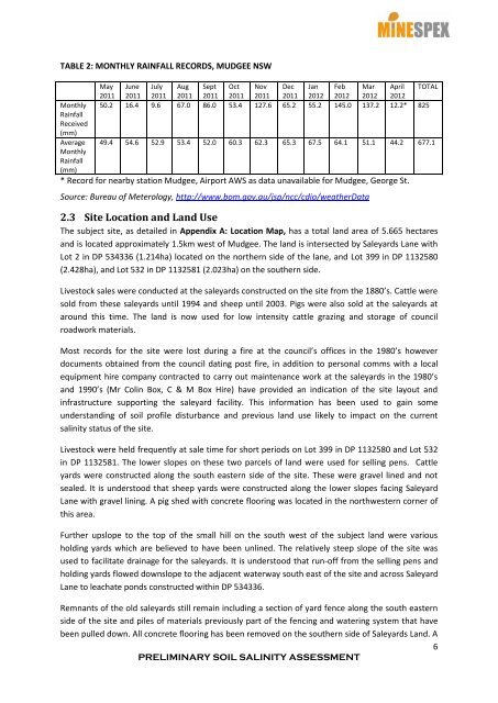
TABLE 2: MONTHLY RAINFALL RECORDS, MUDGEE NSWMonthlyRainfallReceived(mm)AverageMonthlyRainfall(mm)May June July Aug Sept Oct Nov Dec Jan Feb Mar April TOTAL2011 2011 2011 2011 2011 2011 2011 2011 2012 2012 2012 201250.2 16.4 9.6 67.0 86.0 53.4 127.6 65.2 55.2 145.0 137.2 12.2* 82549.4 54.6 52.9 53.4 52.0 60.3 62.3 65.3 67.5 64.1 51.1 44.2 677.1* Record for nearby station Mudgee, Airport AWS as data unavailable for Mudgee, George St.Source: Bureau of Meterology, http://www.bom.gov.au/jsp/ncc/cdio/weatherData2.3 Site Location and Land UseThe subject site, as detailed in Appendix A: Location Map, has a total land area of 5.665 hectaresand is located approximately 1.5km west of Mudgee. The land is intersected by Saleyards Lane withLot 2 in DP 534336 (1.214ha) located on the northern side of the lane, and Lot 399 in DP 1132580(2.428ha), and Lot 532 in DP 1132581 (2.023ha) on the southern side.Livestock sales were conducted at the saleyards constructed on the site from the 1880’s. Cattle weresold from these saleyards until 1994 and sheep until 2003. Pigs were also sold at the saleyards ataround this time. The land is now used for low intensity cattle grazing and storage of councilroadwork materials.Most records for the site were lost during a fire at the council’s offices in the 1980’s howeverdocuments obtained from the council dating post fire, in addition to personal comms with a localequipment hire company contracted to carry out maintenance work at the saleyards in the 1980’sand 1990’s (Mr Colin Box, C & M Box Hire) have provided an indication of the site layout andinfrastructure supporting the saleyard facility. This information has been used to gain someunderstanding of <strong>soil</strong> profile disturbance and previous land use likely to impact on the current<strong>salinity</strong> status of the site.Livestock were held frequently at sale time for short periods on Lot 399 in DP 1132580 and Lot 532in DP 1132581. The lower slopes on these two parcels of land were used for selling pens. Cattleyards were constructed along the south eastern side of the site. These were gravel lined and notsealed. It is understood that sheep yards were constructed along the lower slopes facing SaleyardLane with gravel lining. A pig shed with concrete flooring was located in the northwestern corner ofthis area.Further upslope to the top of the small hill on the south west of the subject land were variousholding yards which are believed to have been unlined. The relatively steep slope of the site wasused to facilitate drainage for the saleyards. It is understood that run-off from the selling pens andholding yards flowed downslope to the adjacent waterway south east of the site and across SaleyardLane to leachate ponds constructed within DP 534336.Remnants of the old saleyards still remain including a section of yard fence along the south easternside of the site and piles of materials previously part of the fencing and watering system that havebeen pulled down. All concrete flooring has been removed on the southern side of Saleyards Land. A6PRELIMINARY SOIL SALINITY ASSESSMENT