

devilbend natural features reserve management plan - Parks Victoria
devilbend natural features reserve management plan - Parks Victoria
devilbend natural features reserve management plan - Parks Victoria
- No tags were found...

You also want an ePaper? Increase the reach of your titles
YUMPU automatically turns print PDFs into web optimized ePapers that Google loves.
DEVILBEND NATURAL FEATURES RESERVEMANAGEMENT PLANMay 2010
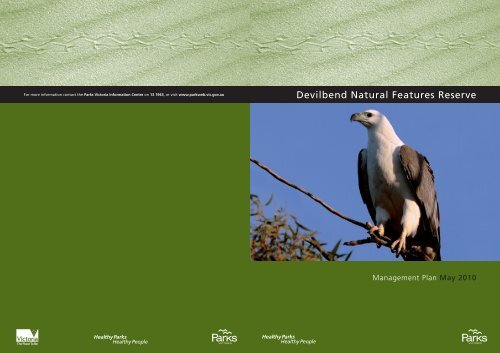
Published in May 2010 by <strong>Parks</strong> <strong>Victoria</strong>Level 10, 535 Bourke Street, Melbourne, <strong>Victoria</strong>, 3000<strong>Parks</strong> <strong>Victoria</strong>, 2010, Devilbend Natural Features Reserve Management Plan, <strong>Parks</strong> <strong>Victoria</strong>, Melbourne.Cover: White-bellied Sea-Eagle at Devilbend, photograph courtesy of Glenn Ehmke.National Library of Australia Cataloguing-in-Publication entryDevilbend Natural Features Reserve Management Plan / <strong>Parks</strong> <strong>Victoria</strong>.ISBN 9780731183852 (pbk)Bibliography.National parks and <strong>reserve</strong>s - <strong>Victoria</strong> – MorningtonPeninsula -- Management.Devilbend Natural Features Reserve .333.783099452AcknowledgementsAcknowledgement of Country: In their rich culture, Indigenous Australians are intrinsically connectedto the continent — including the area now known as <strong>Victoria</strong>. <strong>Parks</strong> <strong>Victoria</strong> recognises that the<strong>reserve</strong> is part of Country of the Traditional Owners.<strong>Parks</strong> <strong>Victoria</strong> is grateful to all those organisations and individuals who have contributed to thisManagement Plan. Special thanks go to the Devilbend Reserve Management Plan Advisory Group:Liz Barraclough, Tom Camp, Steve Compton, Dr Brian Cuming, Jamie Edgerton, Glenn Ehmke,Garrique Pergl, Roger Richards, Adrienne Smith, Cr Brian Stahl, Cr Reade Smith, Jon Theobald,Susan Todd and Gidja Walker. Thanks are also extended to Rob Ogden, Val Ford, Jan Oliver andGillian Tolley in their roles as alternative representatives for members of the Group. Also thanks toPeter Lawson, Matt Ward and Travis Dowling from the Department of Primary Industries for theirtechnical advice to the Group.Notes:<strong>Parks</strong> <strong>Victoria</strong> wishes to advise that the members of the Advisory Group have disparate views on elements of theManagement Plan and that not all members support all the <strong>management</strong> directions.Technical terms used in this <strong>plan</strong> are explained in the Glossary at the end of the <strong>plan</strong>.This Management Plan adopts the spellings used by the Native Title Unit, Department of Justice. Boonwurrungis a known form of the name for this Aboriginal tribal group. Boonwurrung may also be spelt in a number ofdifferent ways, including ‘Boon wurrung, Boonerwrung and Bunurong’DisclaimersThe <strong>plan</strong> is prepared without prejudice to any future negotiated outcomes between the Government/s and<strong>Victoria</strong>n Aboriginal communities. It is acknowledged that such negotiated outcomes may necessitateamendment of this <strong>plan</strong>.Every effort has been made to ensure that the information in this <strong>plan</strong> is accurate. <strong>Parks</strong> <strong>Victoria</strong> does notguarantee that the publication is without flaw of any kind and therefore disclaims all liability for any error, lossor other consequence that may arise from you relying on any information in the publication.Text printed on 100% recycled paper to help save our <strong>natural</strong> environmentiiDevilbend Natural Features Reserve Management Plan
SUMMARYDevilbend Natural Features Reserve (1005 ha)was formally <strong>reserve</strong>d in March 2007, underthe Crown Land (Reserves) Act 1978 (Vic.).Indigenous tradition tells us that the <strong>reserve</strong> ispart of the Country of Boonwurrung people.There are cultural landscapes and importantAboriginal heritage places and objects in the<strong>reserve</strong>. Many places have layers of historyand are important for Aboriginal and broadercommunities. A camp in the area is known bythe Boonwurrung name ‘Daangean’.The area was used for water storage andsupply until 2001 and contains thedecommissioned Devilbend and BitternReservoirs.The <strong>reserve</strong> supports more than 200 species ofindigenous flora and 195 indigenous faunaspecies including threatened species such asthe White-bellied Sea-Eagle and the BluebilledDuck.While the <strong>reserve</strong> contains important remnantnative vegetation areas, much of the land hasbeen cleared for many years and used fororchards and grazing. The <strong>natural</strong> values of the<strong>reserve</strong> and its importance for biodiversityconservation in the broader landscape contexthave potential to be significantly enhancedthrough a focus on the restoration ofindigenous vegetation over time, both withinthe <strong>reserve</strong> and extending out to link with otherareas of remnant vegetation on the MorningtonPeninsula.The <strong>reserve</strong> contains the largest inland waterbody on the Mornington Peninsula providingvaluable habitat for waterbirds and shorebirdsas well as opportunities for recreation. Theopportunities for visitors to access or view thespecial landscapes and settings of theDevilbend and Bittern Reservoirs are uniqueon the Mornington Peninsula.Community groups and individuals wereinstrumental in having the area <strong>reserve</strong>d andhave made a valuable contribution to the<strong>plan</strong>ning and <strong>management</strong> of the <strong>reserve</strong>.The <strong>plan</strong>’s key initiatives are summarised infigure 2. Key elements of the <strong>plan</strong> include:• conservation and protection of thebiodiversity of the <strong>reserve</strong>• implementation of a major program torestore biodiversity values throughrevegetation of degraded and modifiedareas with an emphasis on <strong>natural</strong>regeneration techniques• maintenance of water quality andsustainable water levels in the reservoirs toconserve, protect and enhance ecological,amenity and landscape values• protection of Aboriginal places and objects• recognition of Aboriginal cultural heritageassociated with the <strong>reserve</strong> and respect forthe views of the Boonwurrung people andcultural obligations of Indigenous people• opportunities for community health andwell-being through carefully <strong>plan</strong>nedrecreational use, and education andinvolvement in <strong>management</strong>• provision of opportunities for research andmonitoring to enhance <strong>management</strong> andimprove knowledge on the values of the<strong>reserve</strong>• promotion of partnerships with thecommunity, users and agencies to worktogether and with <strong>Parks</strong> <strong>Victoria</strong> and theBoonwurrung people in all aspects ofmanaging the <strong>reserve</strong>.Devilbend Natural Features Reserve Management Planv
CONTENTSFOREWORDAPPROVED MANAGEMENT PLANSUMMARYiiiivv1 INTRODUCTION 11.1 Location and <strong>plan</strong>ning area 11.2 Creation of the <strong>reserve</strong> 11.3 Plan development 22 BASIS 42.1 Regional context 42.2 Reserve significance and values 42.3 Evidence of past use 52.4 The <strong>reserve</strong> visitor 52.5 Legislation and LCC recommendations 72.6 Policies and guidelines 73 STRATEGIC DIRECTIONS 83.1 Vision 83.2 Management directions 83.3 Management zones 104 CONSERVE, PROTECT AND RESTORE 134.1 Landscape 134.2 Geological <strong>features</strong> 144.3 Reservoirs, creeks and catchments 144.4 Vegetation 164.5 Fauna 184.6 Fire <strong>management</strong> 214.7 Pest <strong>plan</strong>ts and animals and diseases 225 PROTECT AND CONSERVE CULTURAL HERITAGE 255.1 Aboriginal cultural heritage 255.2 Historic heritage 266 VISITING AND ENJOYING 276.1 A place for learning 276.2 Vehicle access 286.3 Visitor experiences 306.4 Walking 306.5 Cycling 336.6 Fishing 336.7 Horse riding 346.8 Tourism services 356.9 Other activities 366.10 Public safety 36viDevilbend Natural Features Reserve Management Plan
Contents7 BEYOND THE BOUNDARIES AND AUTHORISED USES 387.1 Reserve boundaries and adjacent uses 387.2 Water supply infrastructure 397.3 Utility infrastructure 397.4 Occupancies 397.5 Occasional uses 408 INVOLVING COMMUNITY 418.1 Community awareness 418.2 Community participation 428.3 Agency partnerships 439 PLAN IMPLEMENTATION 459.1 Delivery and reporting 459.2 Plan amendment 469.3 Evaluation and review 46REFERENCES 48GLOSSARY 51APPENDICESTABLES1 Draft <strong>management</strong> <strong>plan</strong> submissions 532 Ecological vegetation classes 563 Rare and threatened flora and fauna 574 Major envirnomental weeds 581 Management zones and overlays 112 Summary of recreation opportunites 123 Motor vehicle access <strong>management</strong> 294 Visitor facilities 315 Management of walking trails 32FIGURES1 Location2 Key initiatives3 Management zones4 Management overlays5 Visitor access and facilitiesEnd of <strong>plan</strong>Devilbend Natural Features Reserve Management Planvii
1 INTRODUCTION1.1 Location and <strong>plan</strong>ning areaDevilbend Natural Features Reserve (the<strong>reserve</strong>) covers an area of 1005 hectares and islocated between Hastings and Mornington onthe Mornington Peninsula, 55 kilometressouth-east of Melbourne (figure 1).The <strong>reserve</strong> comprises 422 hectares of nativevegetation, almost 250 hectares of watersurface area associated with Devilbend andBittern Reservoirs, 328 hectares of non-nativevegetation predominately in the form ofcleared grazed land and a five hectare picnicarea (the former Devilbend Reservoir Park).The <strong>plan</strong>ning area also covers 33 hectares ofwater supply <strong>reserve</strong>s managed by MelbourneWater which contains pipelines and associatedinfrastructure required for water supply to theMornington Peninsula. These water supply<strong>reserve</strong>s are included in the <strong>plan</strong>ning area onthe basis that a <strong>management</strong> agreement will beprepared with Melbourne Water to enablethese <strong>reserve</strong>s to be managed for park purposesin a manner consistent with their primarypurpose (section 7.1).The Melbourne Water <strong>reserve</strong>s containsignificant sections of the existing<strong>management</strong> vehicle track network within the<strong>plan</strong>ning area. These tracks provide forrecreational trails to link <strong>features</strong> and accessview points and use of the existing tracksreduces the need for new trails.1.2 Creation of the <strong>reserve</strong>Bittern Reservoir was built in the 1920s as anoff-stream water storage, supplied by pipelinefrom Melbourne’s metropolitan catchments.Building of the Devilbend Reservoir began in1956 with farmland being compulsorilyacquired for the purpose of water supply.Premier Bolte opened the reservoir on 28January 1965.In the late 1990s, a new water supply pipelinefrom Cardinia Reservoir to Pearcedale wascommissioned, providing sufficient capacity tomeet demand and making redundant the needto store water in Devilbend and BitternReservoirs. In 2000-2001, Melbourne Waterremoved Devilbend and Bittern Reservoirsfrom the water supply network and initiated amaster <strong>plan</strong>ning process to consider options forthe future use of the land and water bodies.Following exhibition of the Draft Master Plan(Melbourne Water 2002), the Minister forEnvironment and Water established a workinggroup to review and provide recommendationson the future of Devilbend. The working groupprepared the Devilbend Working GroupSummary Report (DSE 2004a) for theMinister.In January 2006, the Minister announced thegovernment’s intention to establish a newDevilbend Park.In September 2006, most of Devilbend wastransferred to the Crown and the Ministerannounced that the area would be <strong>reserve</strong>d as aNatural Features Reserve under the CrownLand (Reserves) Act. Devilbend NaturalFeatures Reserve was gazetted on 8 March2007 for the protection of <strong>natural</strong> <strong>features</strong>under Section 4(1) of the Crown Land(Reserves) Act.Natural Feature Reserves are one of fourcategories of conservation <strong>reserve</strong>s in <strong>Victoria</strong>.Natural Feature Reserves often provide theonly suitable habitat for many common anduncommon species that either still use or wereonce widespread in land types that have beenlargely cleared. These <strong>reserve</strong>s also contributeto our well-being, when used for recreation,relaxation, scenic landscape appreciation,education and protection against landdegradation (<strong>Parks</strong> <strong>Victoria</strong> 2003).<strong>Parks</strong> <strong>Victoria</strong> is the Committee ofManagement for the <strong>reserve</strong>, appointed underSection 14(2) of the Crown Land (Reserves)Act.The <strong>reserve</strong> is managed in accordance withoverarching <strong>management</strong> objectives derivedfrom Government-accepted former LandConservation Council (LCC)recommendations. These objectives are:• Conserve and protect the <strong>natural</strong> <strong>features</strong>and values of the <strong>reserve</strong>, including anyindigenous flora and fauna, maintainscenic <strong>features</strong> and landscapes, andp<strong>reserve</strong> <strong>features</strong> of geological andDevilbend Natural Features Reserve Management Plan 1
Introductiongeomorphological interest (Primaryobjective).• Conserve and protect any cultural andhistoric <strong>features</strong> and associations.• Protect historic and Aboriginal culturalvalues and sites.• Provide opportunities for appropriateenjoyment, recreation and education by thepublic, and research and study where thisdoes not conflict with the primaryobjective (<strong>Parks</strong> <strong>Victoria</strong> 2003).1.3 Plan developmentThis Management Plan for the <strong>reserve</strong> wasprepared by <strong>Parks</strong> <strong>Victoria</strong> on the basis ofexisting information, reports and researchfindings that relate to the <strong>reserve</strong>.A number of studies were undertaken byMelbourne Water during the master <strong>plan</strong>ningprocess including studies into fresh waterecology, flora, fauna and archaeology andhydrology of the area.Melbourne Water also commissioned studiesto report on hydrology, water quality andfuture <strong>management</strong> of the two reservoirs(GHD 2002 and 2004).<strong>Parks</strong> <strong>Victoria</strong> commissioned additionalresearch to build upon these studies and informthe development of this <strong>plan</strong>. This researchincluded a flora and fauna assessment(Practical Ecology 2008), hydrologicalmodelling (GHD 2008), a fish survey(McGuckin 2007), an assessment ofrecreational impacts and stocking with fish onwaterbirds and shorebirds (ARI 2009) and anaquatic habitats ecosystem study (MonashUniversity 2009). The <strong>plan</strong> is also informedand supported by a range of best practice<strong>management</strong> systems.Significant input of information and advicewas sought and received from the DevilbendNatural Features Reserve Management PlanAdvisory Group and community groups,individuals and agencies with particularinterests in the <strong>reserve</strong>.The community was provided with theopportunity to input into the preparation of theDraft Management Plan through a ‘Have YourSay’ process, a risk assessment workshop, apublic meeting to discuss equestrian interests,a community workshop (Sustainable FuturesAustralia 2007) and through comments on anissues paper addressing recreation and accessissues.The Draft Management Plan was published forpublic comment in December 2008, and 151submissions were received (appendix 1).Where necessary, further consultation with thecommunity and stakeholders was undertaken.Key changes made to the Draft Plan inpreparing this approved Management Planinclude:• applying the conservation zone overadditional areas of conservationsignificance and/or importance incatchment protection• applying the special protection area to partof the shoreline to prevent visitorsdisturbing waterbirds and waterbird habitat• reducing the level of development atBittern Reservoir and changing the zoningfrom Recreation to Conservation andRecreation• relocating the proposed car park at DerrilRoad to link with a viewing pointoverlooking Devilbend Reservoir• updating the <strong>plan</strong> to encompass the resultsof additional research into the impacts ofrecreation on waterbirds (ARI 2009) andfreshwater ecology (Monash University2009)• including further detail on previoushydrological studies and a strategy toprovide for water quality monitoring• providing additional detail on matters to beconsidered in the preparation of acomprehensive restoration program• including a strategy to prepare a fireprotection <strong>plan</strong>• including provision for a heritageassessment of past land use especiallyorcharding• including additional detail on measures tominimise impacts of recreation in further<strong>plan</strong>ning for visitor use• providing for integrated <strong>plan</strong>ning with theMornington Peninsula Shire in relation toroads and recreational trails2 Devilbend Natural Features Reserve Management Plan
Introduction• providing for designated walking onlytrails at Daangean Point and BitternReservoir.This <strong>plan</strong> is a strategic guide for future<strong>management</strong> of the <strong>reserve</strong>. As a publicdocument, the <strong>plan</strong> establishes how <strong>Parks</strong><strong>Victoria</strong> will protect the <strong>reserve</strong>’s <strong>natural</strong> andcultural values and describes the services andfacilities that will be provided to help visitorsto enjoy, appreciate and understand the <strong>reserve</strong>in ways that are consistent with this. The <strong>plan</strong>also serves to inform and encouragecommunity participation in <strong>management</strong>programs, cooperative land <strong>management</strong> andparticipation in community-based programs.As a working document for the <strong>reserve</strong>, the<strong>plan</strong> informs <strong>Parks</strong> <strong>Victoria</strong>’s development ofCorporate Plans, serves as a framework forsubsequent detailed <strong>plan</strong>ning and governs<strong>management</strong> activities.This Management Plan directs future<strong>management</strong> of the Devilbend Natural FeaturesReserve until reviewed (section 9.3).Devilbend Natural Features Reserve Management Plan 3
2 BASIS2.1 Regional contextThe <strong>reserve</strong> is accessible from Melbourne viathe Moorooduc and Western Port Highways.The <strong>reserve</strong> is surrounded by rural areasbetween the townships of Hastings andMornington in the Mornington PeninsulaShire.The Mornington Peninsula offers significantcoastal recreational opportunities, particularlyswimming, fishing and surfing. In contrast, the<strong>reserve</strong> provides an opportunity to focus onnature appreciation and recreational activitiesin a landscape featuring the only major inlandwater bodies within the Peninsula’s parks and<strong>reserve</strong>s system.The <strong>reserve</strong> is part of the Country of theBoonwurrung people and comprises material,spiritual <strong>features</strong> and customary components ofsignificance to Indigenous people.The <strong>reserve</strong> is within Tourism <strong>Victoria</strong>’sMornington Peninsula campaign region, whichin 2007, received over 3.5 million domesticdaytrip visitors and 1.1 million overnightvisitors (Tourism <strong>Victoria</strong> 2008a).The <strong>reserve</strong> is complemented by a number ofnearby parks and <strong>reserve</strong>s including ArthursSeat State Park, Mornington PeninsulaNational Park, Langwarrin Flora and FaunaReserve, Pines Flora and Fauna Reserve,Frankston Natural Features Reserve, WoodsReserve, Warringine Park and the BriarsHistoric Park. The <strong>reserve</strong> contributes to anincrease in the diversity of opportunities forenjoyment, recreation and education in theparks and <strong>reserve</strong>s network on the MorningtonPeninsula.The <strong>reserve</strong> is within the Gippsland PlainBioregion. Approximately 18% of thebioregion remains as native vegetation with8.2% in parks and <strong>reserve</strong>s such as Devilbend.An important assemblage of ecologicalvegetation classes (EVCs) which are rare,vulnerable or endangered in the bioregionoccur within the <strong>reserve</strong> (appendix 2).The <strong>reserve</strong> is in the Port Phillip Catchment inthe Port Phillip and Western Port CatchmentManagement Authority’s area ofresponsibility. The Port Phillip andWesternport Regional Catchment Strategy(PPWPCMA 2004), identifies actions andstrategies for the <strong>management</strong> of land, waterand biodiversity in the region. The DevilbendCreek, which has been significantly modifiedby the construction of the reservoirs and catchdrain, flows through the <strong>reserve</strong>.The <strong>reserve</strong> is part of the MorningtonPeninsula and Western Port BiosphereReserve, designated under United NationsEducational, Scientific and CulturalOrganisation’s (UNESCO) Man and theBiosphere Program in November 2002.Many people have strong associations with the<strong>reserve</strong> as was evident by the communityaction that led to its reservation. There issignificant interest in the <strong>management</strong>,maintenance and restoration of the area,particularly as a refuge for biodiversity on thePeninsula in the face of climate change.2.2 Reserve significance and valuesOne of almost 3000 conservation <strong>reserve</strong>s in<strong>Victoria</strong>, the <strong>reserve</strong> makes a valuablecontribution to <strong>Victoria</strong>’s parks and <strong>reserve</strong>ssystem, which aims to protect viable,comprehensive, adequate and representativesamples of the state’s <strong>natural</strong> environments.The <strong>reserve</strong> is considered to be of statebiodiversity significance and contains twoBiosites which are sites assessed by DSE asbeing of biological significance, supports fiveEVCs of state conservation significance and ishabitat for threatened flora and fauna species(Practical Ecology 2008).The <strong>reserve</strong> makes a valuable contribution tothe retention of biodiversity on the Peninsula.Its central location and the potential to restorethe land will significantly increase its value asa core from which habitat links can be createdbeyond the boundaries of the <strong>reserve</strong>.In times of climate change, parks and <strong>reserve</strong>ssuch as Devilbend will play a pivotal role inthe conservation of biodiversity in <strong>Victoria</strong>.The Mornington Peninsula Planning Schemehas zoned the <strong>reserve</strong> as Public ConservationResource Zone and recognises the landscapeand environmental values of the <strong>reserve</strong>through the application of Scenic Landscape4 Devilbend Natural Features Reserve Management Plan
BasisArea provides basic facilities including a carpark, seating and open space areas.<strong>Parks</strong> <strong>Victoria</strong> estimates the annual visitationto the Picnic Area at 16 000 visits. Visitation ismainly from the local day trip market andvisitors stay up to two hours. Activities aremostly picnicking and bird watching.The creation of the new <strong>reserve</strong> providesopportunities to offer additional areas forvisitor enjoyment and a greater range ofrecreational activities.At a state-wide level, <strong>Parks</strong> <strong>Victoria</strong> has ratedthe <strong>reserve</strong> as a <strong>reserve</strong> of regional value forthe provision of visitor services. Anappreciation of the <strong>reserve</strong>’s <strong>natural</strong> andcultural values will be promoted, together withappropriate enjoyment and recreation.In <strong>plan</strong>ning for visitor use to ensureconsistency with the primary objective forNatural Features Reserves, particular emphasishas been given to the following key studiesand reports:• the Devilbend Working Group SummaryReport (DSE 2004a)• the Practical Ecology Flora and FaunaAssessment and Recommendation Report(Practical Ecology 2008)• the Arthur Rylah Institute forEnvironmental Research report on theimpact of recreational access and stockingwith fish on waterbirds and shorebirds –Devilbend Reserve (ARI 2009)• the Archaeological Investigation andHeritage Management Plan for Devilbendand Bittern Reservoirs (Stage 2) (Rhodes2002).The DSE Working Group Summary reportidentified that recreational activities that canbe compatible with conservation objectives,especially activities that are not well providedfor elsewhere on the Mornington Peninsula,may be provided for. Access for visitors to thequality settings provided by the water bodiesfor walking, bird observation, natureappreciation, photography and art and inlandfishing is a particularly unique opportunity onthe Mornington Peninsula.Opportunities for recreation need to considerthe recommendations of Practical Ecology inregard to limiting shoreline access to relativelyfew areas, utilising existing tracks and catchdrains for walking and cycling and providingfor adaptive <strong>management</strong> in response topotential adverse impacts of recreation.Given the historical protection of these habitatsfrom visitors, a key consideration in providingopportunities to access the shorelines is thelevel of disturbance to waterbirds andshorebirds. The ARI literature review ofrecreational disturbance on waterbirds andshorebirds and on-site assessment of potentialimpacts of shoreline access and recreation atthe <strong>reserve</strong> identified that opening the <strong>reserve</strong>to visitor use will cause some short-termdisturbance to waterbirds. The study concludedthat the large size of the <strong>reserve</strong> combined withcontrols on shoreline access will, under themost likely scenario, enable waterbirds to haveample opportunity to move away from peoplein the short-term and find alternative habitatfor feeding (ARI 2009).Importantly, ARI predicted that the levels ofdisturbance from recreational use are notexpected to cause a reduction in birdpopulations and that there is plenty of scope tomanage increased numbers of visitors whileproviding adequate seclusion to maintainpopulations of waterbirds, particularly at thelarger Devilbend Reservoir.Nevertheless ARI recommended aconservative approach to <strong>management</strong> becauseof the uncertainty in predicting the severity ofresponses of birds at Devilbend Reserve to thepresence of humans. The approach includesmonitoring visitor usage and behaviour, habitatusage of waterbird species and direct responseof the species to visitor activities.The presence of known Indigenous culturalsites and likely presence of further sites acrossthe <strong>reserve</strong>’s landscape necessitates specialcare to ensure protection of cultural heritagevalues from visitor activities and establishmentof visitor facilities as recommended by Rhodes2002.<strong>Parks</strong> <strong>Victoria</strong> is committed to working withthe community to implement the <strong>plan</strong>,including further <strong>plan</strong>ning for visitor use.Community contribution to increasingknowledge is highly valued and important indeveloping adaptive responses that may berequired to mitigate emerging risks. <strong>Parks</strong><strong>Victoria</strong> is also committed to providing for the6 Devilbend Natural Features Reserve Management Plan
Basisenjoyment and appreciation of the <strong>reserve</strong> byboth current and future generations.2.5 Legislation and LCCrecommendationsLegislationThe <strong>reserve</strong> is <strong>reserve</strong>d under Section 4(1) ofthe Crown Land (Reserves) Act 1978 (Vic.) forthe protection of <strong>natural</strong> <strong>features</strong>.The Aboriginal Heritage Act 2006 (Vic.)applies to the <strong>reserve</strong> and protects allAboriginal cultural heritage values includingplaces and objects (section 5.1).The Flora and Fauna Guarantee Act 1988(FFG Act) is the key piece of <strong>Victoria</strong>nlegislation for the conservation of threatenedspecies and communities and for the<strong>management</strong> of potentially threateningprocesses. The FFG Act applies to 13 listedspecies present in the <strong>reserve</strong>.The Environment Protection and BiodiversityConservation Act 1999 (Cwlth) applies to thewhole of the <strong>reserve</strong> with respect to actionsthat have, will have or are likely to have, asignificant impact on matters of nationalenvironmental or cultural significance,including listed threatened species andcommunities and listed migratory species.The Planning and Environment Act 1987(Vic.) applies to the <strong>reserve</strong>. The <strong>reserve</strong> iszoned for Public Conservation and Resource(PCRZ) in the Mornington Peninsula PlanningScheme.The Fisheries Act 1995 (Vic.) provides thelegislative framework for the regulation,conservation and <strong>management</strong> of fisheriesincluding aquatic habitats.LCC recommendationsRecommendations (D60) made by the formerLand Conservation Council (LCC) relate to the<strong>reserve</strong>’s former function as a water supplyreservoir (LCC 1994). The LCC acknowledgedthe area’s botanical, habitat and faunalsignificance and recommended these values beprotected. The recommendationsacknowledged the use of the small Picnic Areaas parkland. The relevant objectives for usingthe broader area as parkland are included insection 1.2.2.6 Policies and guidelinesThe <strong>reserve</strong> is managed in accordance withvarious strategies, <strong>plan</strong>s and operationalpolicies and guidelines including thefollowing:• Conservation Reserves ManagementStrategy (<strong>Parks</strong> <strong>Victoria</strong> 2003).• Management Directions for ConservationReserves (NRE 1999).• Indigenous Partnership Strategy andAction Plan (<strong>Parks</strong> <strong>Victoria</strong> 2005).• Guidelines for Working with AboriginalCommunities and Protection of CulturalSites (<strong>Parks</strong> <strong>Victoria</strong> 2002).• National Strategy for EcologicallySustainable Development (COAG 1992).• National Strategy for the Conservation ofAustralia’s Biological Diversity (ANZECC2001).• <strong>Victoria</strong>’s Biodiversity Strategy (NRE1997).• Code of Practice for Fire Management onPublic Land (DSE 2006).• Guidelines and Procedures for EcologicalBurning on Public Land in <strong>Victoria</strong> (DSE2004b).The <strong>reserve</strong> is also managed within a broadercontext of a number of other strategies andpolicies, including:• <strong>Victoria</strong>’s Nature-Based Tourism Strategy2008-2012 (Tourism <strong>Victoria</strong> 2008b).• The Port Phillip and Western PortRegional Catchment Strategy 2004-2009(PPWPCMA 2004).• <strong>Victoria</strong>’s Public Land Phytophthoracinnamomi Management Strategy (DSE2008b).• Policy for Sustainable Recreation andTourism on <strong>Victoria</strong>'s Public Land (NRE2002a).• Licensing System for Tour Operators andActivity Providers on Public Land in<strong>Victoria</strong> (DSE 2008a).Devilbend Natural Features Reserve Management Plan 7
3 STRATEGIC DIRECTIONS3.1 VisionThe White-bellied Sea-Eagle soaring highabove the <strong>reserve</strong> surveys a vitally importantand much valued landscape in which naturecontinues to heal.The <strong>reserve</strong> is the <strong>natural</strong> heart of theMornington Peninsula providing a core ofremnant indigenous vegetation graduallyexpanding and regenerating under the guidinghand of land managers and volunteers. Birdscontinue to flock to the waters of the <strong>reserve</strong>;the largest and most significant area of freshwater on the Peninsula. The <strong>reserve</strong> showcasesthe reversal of declining biodiversity on thePeninsula.The cultural landscape retains evidence of theBoonwurrung people’s connection to the landand inundation of the land for water storage.The Sea-Eagle is safe but wary of the humansinteracting with the environment and enjoyingthe special ambience of the water andshoreline, which provide a sense of well-being.Visitors gain knowledge and appreciate boththe <strong>reserve</strong>’s <strong>natural</strong> <strong>features</strong> and its storythrough quality interpretation and directinteraction with the environment as they walk,picnic, cycle, ride their horse or fish.They respect the measures in place to ensurethe protection of the <strong>reserve</strong>’s significantvalues and provide for an enjoyable andrewarding experience; they access the <strong>reserve</strong>through sensitively designed and locatedfacilities.The Sea-Eagle’s protection and that of all the<strong>natural</strong> communities in the <strong>reserve</strong>, continuesto be enhanced by the application ofknowledge gained through research andmonitoring.Restoration and conservation techniques haveset a benchmark for the region that inspirenearby landowners and others well beyond theboundaries to facilitate sympathetic habitatrestoration on their properties to furtherenhance the value of the <strong>reserve</strong> as sustainablehabitat. Through the dedication of volunteers,students, friends and Landcare groups andthrough partnerships with the Boonwurrungpeople, the <strong>reserve</strong> has benefited from a longtermconservation program to restore itsbiodiversity.3.2 Management directionsThe Boonwurrung people’s knowledge andinterests in the area and aspirations for Countrywill be reflected in the <strong>reserve</strong>’s <strong>plan</strong>ning and<strong>management</strong>, in accordance with legislationand policies (<strong>Parks</strong> <strong>Victoria</strong> 2005).Other major <strong>management</strong> directions for the<strong>reserve</strong> are outlined below.Conserve, protect and restore• Natural values will be identified, protectedand enhanced in a holistic approach tolandscape, ecology and cultural heritage.• Focus will be on conserving and restoringsignificant vegetation communities andenhancing habitat values. The restorationof Grassy Woodlands, Swamp Scrub,Damp Heath and Swampy RiparianWoodland will be given priority.• A landscape ecology approach torestoration of native vegetation will beapplied and <strong>natural</strong> regeneration will beencouraged where feasible.• The habitat values of the Devilbend andBittern Reservoirs will be maintained.Water levels and water quality ofDevilbend and Bittern Reservoirs andDevilbend Creek will be managed toenhance habitat values and protectenvironmental flows.• Protection of the FFG Act listed BluebilledDuck and White-bellied Sea-Eaglewill be given priority.• Protection and enhancement programsbased on current knowledge, riskassessments and applied research will beused in the <strong>management</strong> of threats to<strong>natural</strong> values. Pest <strong>plan</strong>t control will begiven priority.• Ecological principles will be applied in theuse and <strong>management</strong> of fire in the <strong>plan</strong>ningarea for resource conservation and <strong>reserve</strong>protection purposes.8 Devilbend Natural Features Reserve Management Plan
Strategic directions• Management will be adaptive to respond toexisting threats such as disease, pest <strong>plan</strong>tsand animals and emerging threats such asclimate change.• Flora and fauna research and monitoringwill be undertaken to enhance knowledgeabout risks to <strong>natural</strong> values and inform anadaptive <strong>management</strong> approach toprograms.Protect and conserve cultural heritage• Indigenous cultural obligations relating toCountry will be respected and Indigenousknowledge promoted and interpreted inaccordance with the views of theBoonwurrung people.• Aboriginal places and objects will beprotected from interference or damagingactivities.• Opportunities for shared learning will beexplored, particularly opportunities withBoonwurrung people.• Historic relics and places will beconserved by protecting them fromdamaging activities.• The impact of any works and infrastructureon the <strong>reserve</strong>’s <strong>natural</strong> and cultural valueswill be minimised by careful <strong>plan</strong>ning,design and construction activities.• Research into Indigenous and historiccultural heritage of the <strong>reserve</strong> will beencouraged and supported in consultationwith the Boonwurrung people and widercommunities.A place of learning• A range of information and interpretationservices will be used to enhance visitorunderstanding, appreciation and respect forthe <strong>reserve</strong>’s values.• Learning through participation in activitiesin the environment will be encouraged tofoster understanding and appreciation ofthe <strong>reserve</strong>’s values.• Monitoring will be undertaken to assesslevels of use, and the impact of recreationactivities and visitors on waterbirds,waterbird use of habitat, and other <strong>natural</strong>and cultural values to inform <strong>management</strong>decisions.• Scientific knowledge of the ecologicalprocesses and <strong>natural</strong> systems within the<strong>reserve</strong> will be enhanced by fosteringintegrated research.• Friends, volunteers and other interestgroups will be encouraged to continue todevelop an understanding and appreciationof the <strong>reserve</strong>’s values and the rich anddiverse knowledge and aspirations of theBoonwurrung people.Visiting and enjoying• Use of the <strong>reserve</strong> for health and wellbeingwill be promoted.• A range of quality recreational experienceswill be maintained at sustainable levels.• Development of visitor facilities andaccess will be staged and will ensureminimal impacts on <strong>natural</strong> and culturalvalues.• Access to sections of the shoreline will bemanaged to prevent disturbance tosensitive waterbirds and waterbird habitatand ensure minimal impacts on ecologicalvalues and protection of cultural values.• Visitors will be encouraged to adoptminimal-impact techniques and to adhereto developed standards suitable for theiractivity.Involving community• The Boonwurrung people will beencouraged to advise on and participate in<strong>management</strong>, including research activities,ecological <strong>management</strong> programs andcultural activities, guided tours and sharedlearning experiences.• The wider community will be encouragedto become more aware of the <strong>reserve</strong> andappreciate its values.• Local communities and neighbours will beencouraged to continue to develop a senseof custodianship for the <strong>reserve</strong>.• Co-operative relationships will be nurturedwith communities and groups that areinterested in the <strong>reserve</strong>’s <strong>management</strong> tosupport and strengthen their involvementthrough ongoing opportunities andprograms.Devilbend Natural Features Reserve Management Plan 9
Strategic directions• Collaborative relationships will bedeveloped with agencies and neighbouringland managers to improve habitatconnectivity in the broader landscape.• Collaborative partnerships will be soughtwith research and education institutions topursue research and monitoring of the<strong>reserve</strong>’s values.• Co-operative relationships will bedeveloped with neighbours to encouragesensitive land <strong>management</strong> techniques onadjoining land and the protection of bothprivate property and public land from fire.3.3 Management zonesReserve <strong>management</strong> zoning:• provides a geographic framework in whichto manage the <strong>reserve</strong>• reflects sensitivity and fragility of <strong>natural</strong>values• indicates which <strong>management</strong> directionshave priority in different parts of the<strong>reserve</strong>• indicates the types and levels of useappropriate throughout the <strong>reserve</strong>• assists in minimising existing and potentialconflicts between uses and activities, orbetween uses and activities and theprotection of the <strong>reserve</strong>’s values• provides a basis for assessing thesuitability of future activities anddevelopment proposals.Three <strong>management</strong> zones apply to the <strong>reserve</strong> -Conservation, Conservation and Recreationand Recreation (table 1 and figure 3).Special Management Overlays are used tohighlight restoration priorities. A SpecialProtection Area has been used to highlightpriority areas for the protection of waterbirdsand waterbird habitat (table 1 and figure 4).Details of zone and overlay characteristics areprovided in table 1 and recreation opportunitieswithin zones in table 2.10 Devilbend Natural Features Reserve Management Plan
Strategic directionsTABLE 1MANAGEMENT ZONES AND OVERLAYSZONE/ OVERLAY AREA/LOCATION* VALUES MANAGEMENT AIMZONES*Conservation Approx. 479 hectares, 45%of the <strong>reserve</strong>Conservation andRecreationApprox. 579 ha, 54.7% ofthe <strong>reserve</strong> - predominantlyapplies to pasture andboundary areas and theDaangean Point andabutting watersBroad areascontaining sensitive<strong>natural</strong> environmentsor ecosystems.Important <strong>natural</strong>,landscape andcatchment values withremnant areas ofindigenous vegetationand scope forrecreationopportunities.Conserve and enhance <strong>natural</strong> values. Providefor low key trail access, subject to ensuringminimal interference with <strong>natural</strong> processes.Protect <strong>natural</strong> environments and provide forsustainable, dispersed recreation activitiesand small-scale recreational facilities withoutsignificant impact on <strong>natural</strong> processes.Restore <strong>natural</strong> values of terrestrial areas toenhance protection of conservation zone overtime.RecreationApprox. 3 ha, 0.3% of the<strong>reserve</strong> – applies to theexisting Devilbend PicnicArea locationSites with visitor andaccess facilities in a<strong>natural</strong> setting andrelatively lowerhabitat value.Provide for high use and high quality,sensitively located visitor facilities such ascar parking, picnic and toilet facilities, trailheaders and access to the water’s edge.OVERLAY/SSpecialManagement –short-termrestorationApprox. 276 ha, 26% of<strong>reserve</strong>Areas of existingregeneration andcleared areas offormer farmland andorchards, includingsome areas currentlygrazed.Short-term (0-10 years) restoration ofindigenous flora, rehabilitation of grasslandsand enhancing depleted woodlands.Priorities include consolidating buffers toshorelines and stream/drainage lines andenhancing visitor experiences (e.g. atDaangean Point)Provision for grazing as a <strong>management</strong> toolbut to be phased out in short-term. Provisionof through trails.SpecialManagement –long-termrestorationApprox. 318 ha, 30% of<strong>reserve</strong>Areas of highlydepleted woodlandand cleared areas offormer farmland andorchards, includingareas currently grazedthat have potential forrestoration in thelong-term.Long-term restoration (10 years plus) ofindigenous flora, rehabilitation of grasslandsand enhancing depleted woodlands. Provisionfor grazing as a <strong>management</strong> tool to bephased out over the longer-term. Provision ofthrough trails.Special ProtectionAreaApprox. 91 ha, 9% of<strong>reserve</strong>Area of shorelineproviding valuablehabitat values forwaterbirds.Protect waterbirds and waterbird habitatalong shorelines from disturbance fromvisitors.* The total area covered by the <strong>management</strong> zones is greater than the 1005 ha Devilbend Natural Features Reserve as thezoning is extended over the 33 ha Water Supply Reserves controlled and managed by Melbourne Water.Devilbend Natural Features Reserve Management Plan 11
Strategic directionsTABLE 2SUMMARY OF RECREATION OPPORTUNITIESACTIVITY*MANAGEMENT ZONECONSERVATIONCONSERVATION ANDRECREATIONRECREATION(percentage of <strong>reserve</strong>) (45%) (54.7%) (0.3%)Bird watching Y Y YCampfires** N N NCamping – designated (no facilities) (section 6.9) N S NCycling (section 6.5) Y Y YDog walking (section 6.9) N N NEducation/Guided activities(section 6.1) YC YC YCFires in gas or liquid-fuel appliances N N YHorse riding (section 6.7) N Y YLicensed tours (section 6.8) YC YC YCNature photography/Painting Y Y YOrienteering/Rogaining (section 6.9) S S SPicnicking (section 6.3) N N YRafting/Canoeing/Kayaking (section 6.9) N S N/AShore-based fishing (section 6.6) Y Y N/ASwimming (section 6.9) N N N/AWalking (section 6.4) Y Y YKey:YNN/AYCSYes—subject to conditions prescribed by legislation, licensed tour permits or elsewhere in the <strong>plan</strong> as indicatedNot permittedNot applicableSubject to permit conditionsSubject to monitoring, research and/or future demand* Staged access to the Special Management areas will be provided initially via trails. Access to the shoreline will beprovided outside the Special Protection Area** May be provided for in association with approved events such as Indigenous ceremonies12 Devilbend Natural Features Reserve Management Plan
4 CONSERVE, PROTECT AND RESTORE4.1 LandscapeThe landscape is significant to theBoonwurrung people who referred to the areaas Daangean (Rhodes 2002).The <strong>reserve</strong> has a range of landscape settingsfrom <strong>natural</strong>, to semi-rural and highlymodified.The <strong>reserve</strong>’s highest valuelandscapes are those associated with the waterbodies and views across the reservoirs, andassociated bushland.The <strong>reserve</strong>’s landscape values areacknowledged in the Mornington PeninsulaPlanning Scheme through the application ofSignificant Landscape Overlays. Theobjectives of the overlays are to protect thescenic values from visual intrusion. Extensiverestoration <strong>plan</strong>ned for the <strong>reserve</strong> (section 4.4)has the potential to enhance the <strong>natural</strong>landscape settings.The <strong>reserve</strong> is likely to increase in importancewithin the broader landscape for biodiversitydue to threats from the results of climatechange such as hydrological impacts, potentialdecline of remnant vegetation, changes inecological processes and impacts onregeneration (section 4.3, 4.4, 4.5 and 4.7).The <strong>reserve</strong> offers quality views acrossDevilbend Reservoir, currently appreciatedfrom the Picnic Area and by driving alongGraydens and Hodgins Roads. The topographyand pattern of remnant vegetation, <strong>plan</strong>ted pine<strong>plan</strong>tations and windbreaks, limit views to afew locations (DSE 2004a).There are opportunities to improve the <strong>natural</strong>landscape setting of the <strong>reserve</strong> through theremoval of visually intrusive non-indigenousspecies such as pines and the regeneration of<strong>natural</strong> bushland. Pine removal at BitternReservoir, undertaken primarily due to damagefrom a wildfire in 2007, provides improvedviewing of the water body and facilitatesopportunities for restoration of a more <strong>natural</strong>landscape adjacent to this key feature.Planted windbreaks within those areas of the<strong>reserve</strong> historically used for agriculture,especially orcharding, will be retainedcommensurate with their assessed heritagecontribution to the cultural landscape of the<strong>reserve</strong>. Removal will need to be consideredwhere safety becomes an issue or where thepines threaten adjacent habitat areas. Aheritage assessment of the landscapesassociated with the orcharding history willneed to address long-term <strong>management</strong> of the<strong>plan</strong>ted wind breaks in context with restorationobjectives (sections 4.4 and 5.2).The extensive areas of cleared farmland looksimilar to the surrounding private land buthave been undisturbed and protected fromfurther development since the 1950s by landacquisition for water storage purposes.The <strong>reserve</strong> contains a range of built assetsrelating to past uses such as water supply,horticulture and grazing. These include watersupply infrastructure, fencing, cool stores,powerlines and houses. Some of these assetsare no longer required and can be consideredfor removal if assessed as being of little or nohistorical value (chapter 7).The development of visitor facilities providesopportunities to improve the visitors’appreciation of the landscape. However, it alsohas the potential to alter the landscape values.In opening new areas, it is important tominimise potential impacts on the landscapevalues (section 6.3).Development in areas adjacent to the <strong>reserve</strong>has the potential to impact upon its landscapevalues. Assessment of <strong>plan</strong>ning proposalsneeds to consider potential impacts on viewsinto and from the <strong>reserve</strong> (section 8.3).Aims• Protect and enhance the <strong>natural</strong> landscapeof significance to communities or of highscenic quality while allowing <strong>natural</strong>processes to continue.• Enhance opportunities for visitors to enjoythe landscape.• Minimise visual intrusions into thelandscape and rehabilitate, remove orameliorate undesirable existing intrusions.Management strategies• Ensure that the significance of landscapeto the Boonwurrung people is fullyDevilbend Natural Features Reserve Management Plan 13
Conserve, protect and restoreconsidered in <strong>plan</strong>ning and implementing<strong>management</strong> activities, interpretation andeducation programs (section 6.1).• Ensure that landscape protectionobjectives are included in ecological<strong>management</strong> programs and the provisionof visitor infrastructure (section 6.3).• Liaise with other agencies andorganisations responsible forinfrastructure to ensure protection oflandscape values (section 7.3 and 8.3).• Where possible, remove or replace visuallyintrusive fencing with alternative designs(e.g. fauna friendly designs) and material.• Progressively remove disused and/orunsafe built infrastructure such as housesand cool stores and undertake restorationworks.• Work with Melbourne Water toprogressively remove disused waterstorage infrastructure, subject to a valuesassessment, and ensure restoration of thedisturbed sites (section 7.1).• Progressively remove pine trees which arevisually intrusive on the landscape and/orthreaten habitat values and undertakerestoration works in accordance with anindigenous vegetation restoration <strong>plan</strong>(sections 4.4 and 4.7).• Improve opportunities for visitors toappreciate the landscape and water viewsthrough the provision of access to theshoreline and viewpoints and developmentof master <strong>plan</strong>s (sections 6.2, 6.3 and 6.4).• Minimise impacts on landscape values bymaximising the use of the existing tracknetwork and catch drain embankments forproviding visitor and <strong>management</strong> access(sections 6.2, 6.4, 6.5 and 6.7).4.2 Geological <strong>features</strong>According to Indigenous tradition,geomorphologic <strong>features</strong> are culturallysignificant.Devilbend Creek gorge would have been themost outstanding geological feature prior tothe creation of Devilbend Reservoir. The gorgeextended south several hundred metres fromthe present dam wall location and would havebeen about ten metres deep.There is evidence of quarrying for stone by theBoonwurrung people and extensive quarryingfor the construction of the dam walls. Thequarry sites have exposed the underlyinggeology of the <strong>reserve</strong> and offer a valuableglimpse of the geological landforms that are afeature of the <strong>reserve</strong>.A geological survey conducted in 1967 foundsurface rocks formed from Lower Ordoviciansediments at Devilbend were some of theoldest rocks on the Mornington Peninsula(Jenkins 1979).The eastern part of the <strong>reserve</strong> <strong>features</strong> UpperOrdovician (Palaeozoic 510 to 438 millionyears BP) sandstones, slates and cherts,overlaid along Stumpy Gully Road by morerecent Pliocene sandstones. The sandstonesalso appear west of Bittern Reservoir andextend to Derril Road. Middle to LowerOrdovician sedimentary rocks occur generallyalong both sides of Derril Road, extendingwest into Woods Reserve.Aim• Allow <strong>natural</strong> systems and processes tocontinue undisturbed where possible andminimise impacts by <strong>management</strong> andvisitors on significant geological andlandform <strong>features</strong>.Management strategies• Consider and respect the significance oflandforms to the Boonwurrung people in<strong>plan</strong>ning and implementing <strong>management</strong>activities (section 5.1).• Protect geological <strong>features</strong> fromdisturbance and promote understandingand appreciation of geological processesand <strong>features</strong>.4.3 Reservoirs, creeks andcatchmentsThe <strong>reserve</strong> lies within an area of the PortPhillip catchment typified by rural landscapesand agricultural industry of high value,including horticulture, viticulture, dairy,poultry, equestrian and beef farming.Devilbend Reservoir is the largest inland waterbody on the Mornington Peninsula and one ofthe largest in the Port Phillip and Western Portcatchment. It provides a unique freshwaterhabitat for fauna and a haven for water birds14 Devilbend Natural Features Reserve Management Plan
Conserve, protect and restoreon the Peninsula. Both reservoirs providevaluable habitat for water birds and supportunique aquatic EVCs.The reservoirs have small <strong>natural</strong> catchmentsand the construction of the catch drain aroundthe southern and western perimeters of bothreservoirs was intended to protect waterquality by preventing run-off into thereservoirs.Since the reservoirs were decommissioned in1999, and the supply of pipeline water wasstopped, the water levels in both reservoirshave fallen. Modelling of water flowsundertaken in 2002 for Melbourne Water inrelation to the abandonment of DevilbendReservoir as a water supply (GHD 2002)indicated that Devilbend Reservoir appeared tobe reasonably sustainable at near fullconditions and that Bittern Reservoir wassubject to significant variations in storagelevels and potential emptying depending onlong-term trends in climate.Melbourne Water also commissioned a studyto recommend future works to establishsustainable water levels, establish a waterquality model and desirable treatment worksand provide advice on <strong>management</strong>,maintenance and monitoring regimes (GHD2004).A review of the modelling was commissionedby <strong>Parks</strong> <strong>Victoria</strong> to consider the impact ofclimate change and inform hydrological worksrequired to achieve target water levelsdesirable for environmental purposes of 12 000megalitres (or 90% of capacity) for Devilbendand 450 megalitres (or almost 80% ofcapacity) for Bittern.The modelling indicated that if run-offcontinues to be diverted by the catch drainsBittern Reservoir will dry up and the waterlevel in Devilbend Reservoir will drop to twothirds of capacity (GHD 2008).Modelling of water quality for the period 1979to 2007 based on modelled storage levelsfound that the water quality of the currentsystem shows seasonal variability consistentwith known concentration ranges usinghistorical data (GHD 2008).The hydrological modelling has identified thatit is feasible to maintain sustainable waterlevels within both reservoirs by diverting flowsout of the catch drain during the winter peakflow period (GHD 2008).The proposed catch drain modifications will beimportant in maintaining water levels anddownstream flows to maintain biodiversity andlandscape values of the reservoirs andDevilbend Creek in the face of impacts fromclimate change. Water levels in BitternReservoir have fallen dramatically over thepast three years and urgent consideration needsto be given to establishing inflows.Diversion of flows in the catch drain directlyinto the reservoirs may affect the water qualityof both water bodies as the run-off fromneighbouring properties may containagricultural contaminants and may havesalinity issues. Water quality treatmentmeasures including <strong>plan</strong>ting, bioretentiontrenches and/or wetlands will need to beconsidered for water filtration in proposals toredirect catch drain flows.Improvements to water quality inflows areexpected to be achieved through the restorationof indigenous vegetation in cleared anddegraded areas, giving priority to restoring thecatch drain, drainage lines and stream lines(section 4.4). Water quality downstream is alsoexpected to be improved with restoration of thecatch drain over time.Ongoing water quality monitoring will beimportant for monitoring the <strong>reserve</strong>’s aquatichabitats. <strong>Parks</strong> <strong>Victoria</strong>, in partnership with theDevilbend Foundation and National Trust(<strong>Victoria</strong>) has agreed to develop a program forwater quality monitoring and assessment.Devilbend Creek was highly modified with theconstruction of the reservoirs and catch drain.The creek, which now flows through the<strong>reserve</strong> primarily via the catch drain, originatesjust south of the <strong>reserve</strong> and forms part of theBalcombe Creek catchment. The catch drainflows back into the <strong>natural</strong> course of the creekto the north of the <strong>reserve</strong> via a concretespillway. Any changes to the catch drain flowregime will affect the environmental flowsdownstream.<strong>Parks</strong> <strong>Victoria</strong> and Melbourne Water arecontinuing to undertake research to determineappropriate water regimes to ensure optimalenvironmental flows downstream and waterlevels in the reservoirs.Devilbend Natural Features Reserve Management Plan 15
Conserve, protect and restore<strong>Parks</strong> <strong>Victoria</strong> is responsible for the catchdrain flows and the water in the reservoirs.However, Melbourne Water and SouthernRural Water have responsibilities in regard tothe quantity and quality of flows into and outof the <strong>reserve</strong>.Dwarf Galaxias (Galaxiella pusilla) has beenidentified in the catch drain in the past.However, surveys in 2007 did not locate thisnationally threatened species (McGuckin2007) (section 4.5).Aims• Protect and enhance the aquatic values ofthe Devilbend and Bittern Reservoirs,Devilbend Creek and the catchment.• Manage the hydrology of the site tomaintain sustainable water levels in thereservoirs to enhance ecological, amenityand landscape values.Management strategies• As a high priority, develop and implementa water <strong>management</strong> strategy thatconsiders downstream ecologicalrequirements and downstream userrequirements while providing sustainablewater levels in the reservoirs inconsultation with Melbourne Water andSouthern Rural Water (section 8.3).• Undertake works to the catch drain toprovide some flows into the reservoirsduring the winter peak flow period.• Undertake works required to treat run-offto improve water quality prior to enteringthe reservoirs as determined necessary.• Develop and implement a water qualitymonitoring program to assess changes inhydrology and effectiveness ofimprovements to the catchment.• Liaise with Melbourne Water andSouthern Rural Water to ensure<strong>management</strong> of dams and waterwaysupstream does not have detrimental effectson the hydrology of the <strong>reserve</strong>.4.4 VegetationThere are 11 EVCs represented in the <strong>reserve</strong>,of which seven are endangered, threevulnerable and one rare in the Gippsland PlainsBioregion (Practical Ecology 2008) (appendix2). EVCs cover approximately 32% of theentire <strong>reserve</strong> with Lowland Forest (12.7%)and Grassy Woodland (6.6%) the mostabundant. Just over 10% of the <strong>reserve</strong> consistsof regrowth or modified native vegetation thatcannot be clearly categorised as an EVC. Thebalance is water-covered with an undefinedarea of aquatic vegetation (25%) or non-nativevegetation with predominantly pasture areas(33%).During 2007 the conservation significance ofthe native vegetation was scored in accordancewith the <strong>Victoria</strong>’s Native VegetationFramework (NRE 2002b). Almost all areas ofremnant native vegetation received relativelyhigh ratings, due to their intact nature andlandscape context (Practical Ecology 2008).There are 212 indigenous <strong>plan</strong>t speciesrecorded in the <strong>reserve</strong>. One flora species ofstate significance, the Mauve-tuft Sun-orchid(Thelymitra malvina), was identified in 2001and is listed as vulnerable on DSE’s AdvisoryList (DSE 2005) (appendix 3).The <strong>reserve</strong> supports relatively large areas ofSwamp Scrub (47.6 hectares), which is of statesignificance due to its highly depleted natureand low representation in conservation<strong>reserve</strong>s.The freshwater ecology project commissionedin late 2008 included mapping, description andassessment of the condition of shorelineaquatic vegetation. This study found that noneof the vegetation communities or species waslisted as rare or threatened and was commonlyfound in these habitat types (MonashUniversity 2009). The study also found thatDevilbend Reserve is highly productive, withextensive aquatic and riparian vegetationsupporting amphibian, fish and crayfishcommunities. The benthic zone of DevilbendReservoir is covered in vegetation providingextensive areas of habitat for invertebrates andfish.An increased growth of aquatic vegetationwould benefit birds and may result in increasednumbers of waterbird species being induced tobreed. Planned revegetation of the <strong>reserve</strong> islikely to enhance the habitat for manywaterbird species (ARI 2009).A fungi survey undertaken by the FieldNaturalists Club of <strong>Victoria</strong> in 2007 identified16 Devilbend Natural Features Reserve Management Plan
Conserve, protect and restore58 species of fungi in the <strong>reserve</strong> (FNCV2007).Significant threats to the vegetation in the<strong>reserve</strong> include climate change, invasiveweeds, <strong>plan</strong>t pathogens, altered fire regimes,fragmentation, unrestricted stock grazing andunrestricted visitor access (<strong>Parks</strong> <strong>Victoria</strong>2007) (sections 4.6 and 4.7).A significant proportion of the <strong>reserve</strong> ishighly modified. However, parts of thisdisturbed landscape contain areas of nativevegetation that are <strong>natural</strong>ly regenerating orcontain indigenous ground storey species.These areas have potential for <strong>natural</strong>regeneration, and in some cases more intensiverevegetation, to restore to indigenousvegetation and reduce threats posed byfragmentation.Various hierarchies of habitat corridors withinand extending out of the <strong>reserve</strong> have beenidentified, including recommended priorityshort-term (0-10 years) habitat links within the<strong>reserve</strong> (Practical Ecology 2008). In the longerterm grazing will be phased out toaccommodate restoration across all parts of the<strong>reserve</strong>.A comprehensive vegetation restorationprogram needs to be prepared for the <strong>reserve</strong>based on broad restoration directions shown infigure 4. Development of a program forrestoration will need to consider:• establishment of habitat links identified byPractical Ecology (2008)• revegetation of streamlines and drainagelines to improve water quality inflows intothe reservoirs and catch drain (section 4.3)• enhancement of the catch drain to improvefauna habitat and water quality (sections4.2 and 4.5)• enhancement of shoreline vegetation toprovide additional habitat for waterbirdsand shorebirds (section 4.5)• protection of remnant vegetation of veryhigh conservation significance from threatsincluding invasive woody weeds andhybridisation (section 4.7)• establishment and/or enhancement ofbuffers to sensitive areas includingshorelines, White-bellied Sea Eagle nestsites, Eurasian Coot resting areas and otherspecial habitats• opportunities for large scale revegetationof grazed pasture areas through carbonoffset programs• revegetation of areas for amenity andaesthetics (e.g. pine infested areas)• fire <strong>management</strong> and protection <strong>plan</strong>ningrequirements (section 4.6)• revegetation of shoreline areas inconsultation with the Boonwurrung peopleto protect Indigenous cultural sites andcontrol erosion as recommended by TerraCulture (Rhodes 2002)• cultural landscape assessment and<strong>management</strong> of elements of landscapesignificance (section 5.2)• appropriate timing for staged visitor accessto minimise visitor impacts.While <strong>natural</strong> regeneration is the preferredmethod to restore native vegetation forecological and economic reasons, moreintensive revegetation will be required to reestablishnative vegetation in some parts of the<strong>reserve</strong>, particularly in those areas of the<strong>reserve</strong> identified for long-term restoration(figure 4).Natural regeneration of vegetation will bedependent on factors such as seed supply, soilcondition, predation on seedlings and <strong>natural</strong>processes. It is estimated that 100-200 ha ofthe <strong>reserve</strong> has the capacity to <strong>natural</strong>lyregenerate in the short-term. In the long-term,this area will increase as areas <strong>natural</strong>lyregenerating increase (Practical Ecology2008).The extent and nature of the <strong>natural</strong>regeneration within the <strong>reserve</strong> providesvaluable opportunities for research into andmonitoring of regeneration techniques.Previous vegetation surveys of the <strong>reserve</strong>have recommended additional research into theidentification of significant species includingthe Mauve-tuft Sun-orchid.Indigenous people recognise vegetation as anintrinsic element of Country and theBoonwurrung people maintain a sophisticatedknowledge of its value and uses.Devilbend Natural Features Reserve Management Plan 17
Conserve, protect and restoreAims• Protect, enhance and restore indigenousflora and vegetation communities,particularly threatened species andsignificant EVCs.• Improve knowledge of significant floraand threatening processes to improve<strong>management</strong>, protection and appreciation.Management strategies• Prepare and implement an indigenousvegetation restoration program focusingon <strong>natural</strong> regeneration of short-termrestoration areas, and endangered andrestricted EVCs such as Swamp Scrub,Grassy Woodland, Damp Heathland andSwampy Riparian Woodland.• Reflect Indigenous knowledge ofvegetation in <strong>management</strong> practices wherepracticable.• Implement adaptive <strong>management</strong> wheresuitable to assist vegetation communitiesto respond to the threats of climatechange.• Establish a monitoring program to assessthe success of regeneration including therate of <strong>natural</strong> regeneration and changesin vegetation communities.• Manage visitor activities to minimiseimpacts on flora species and vegetationcommunities (chapter 6).• Encourage further research intosignificant flora species.• Encourage the Field Naturalists Club of<strong>Victoria</strong> to continue fungi surveys in the<strong>reserve</strong>.• Encourage research to identify Indigenouspeople’s knowledge relating to vegetationand harvesting practices.• Respect the cultural obligations of theBoonwurrung people in relation to <strong>plan</strong>tsand their significance in all <strong>management</strong>and visitor activities.4.5 FaunaThe <strong>reserve</strong> is an important habitat area andrefuge for native fauna and supports almost200 native fauna species of which 158 are birdspecies. The two reservoirs provide valuablehabitat for water and shore birds, including 14international migratory bird species. Thesespecies are listed under conservationagreements between Australia, Japan, Koreaand China (Practical Ecology 2008).The Dwarf Galaxias and the Growling GrassFrog have been recorded in the <strong>reserve</strong>. Bothspecies are listed as vulnerable under theEPBC Act. Recent surveys of the catch drainhave failed to rediscover Dwarf Galaxias(McGuckin 2007) and Growling Grass Froghas not been recorded since 1978.There have been 20 state significant speciesidentified over the last 20 years with most ofthese also being observed in the last five years(Practical Ecology 2008) (appendix 3).The <strong>reserve</strong> supports a breeding pair of WhitebelliedSea-Eagles. This species is listed asthreatened under the FFG Act and requiressuitable and undisturbed habitat includingadequately sized areas of native vegetationcontaining large, old growth trees. Breedingsuccess relies upon the availability of remnantstands of tall open woodland (Richards 2007).The White-bellied Sea-Eagle has beenrecorded nesting within the <strong>reserve</strong> since 1999.The Sea-Eagle feeds on fish and birds and issensitive to human disturbance especiallyduring breeding. The FFG Action Statementfor the White-bellied Sea-Eagle requires asuitable buffer zone around nests, from humanand habitat disturbance on public land throughappropriate land <strong>management</strong> practices (DSE2003a).While there is little specific information on theresponses of White-bellied Sea- Eagles todisturbance, other studies have shown thatraptors are highly sensitive to human presencenear nest sites, and some species may besensitive to disturbance as far as 500 metres(approx.) away (ARI 2009).The Blue-billed Duck is listed as threatenedunder the FFG Act. Blue-billed Ducks aresecretive, preferring stable, deep, fresh, wellvegetatedwetlands for much of the year,particularly for breeding (DSE 2003b). BluebilledDuck habitat across the state hasdeclined due to drainage, clearing, grazing,salinity and ground water extractions.Increasing numbers at the <strong>reserve</strong> may indicatethe increased importance the <strong>reserve</strong> plays as18 Devilbend Natural Features Reserve Management Plan
Conserve, protect and restorehabitat for this species (Practical Ecology2008).Restoring and enhancing shoreline and aquaticvegetation (section 4.4) may increase numbersof waterbird species such as the Blue-billedDuck being induced to breed especially if suchareas were protected from visitor disturbance(ARI 2009).There are no specific studies on the responseof Blue-billed Ducks to recreationaldisturbance, however they have a preference toforage in deep water and may be lesssusceptible to disturbance at Devilbend thanspecies which forage close to shorelines (ARI2009).A breeding pair of Caspian Terns has beenrecorded in the <strong>reserve</strong> over recent years. Thisspecies is listed as near threatened under theFFG Act and it is believed that there may onlybe in the order of 100 nesting pairs in <strong>Victoria</strong>(Richard Loyn, Arthur Rylah Institute 14 July2009, pers. comm.).Many of the fauna species would havetraditionally been used by the Boonwurrungpeople including kangaroos, wallabies and birdeggs (Rhodes 2002). The White-bellied Sea-Eagle is also a totem species for someIndigenous groups and holds great spiritualsignificance (National Library Australian2005).The reservoirs are known to support fournative and three introduced fish species, noneof which are considered threatened in Australiaor <strong>Victoria</strong>. The freshwater ecology studycommissioned in 2008 found no threatenedaquatic fauna species (Monash University2009). The study did not find any additionalnative fish species and confirmed the presenceof two exotic fish species in the reservoirs, aswell as Marron in the reservoirs and catchdrain. Four native frog species were found.However, Growling Grass Frog was notlocated although it appears that there isabundant habitat for this species and it may bepresent. The long-necked tortoise was notlocated despite being abundant in a 2001survey.Ongoing monitoring of the freshwater ecologywill increase knowledge on the ecology of thefreshwater habitats and impacts of changes in<strong>management</strong>. The project will include thedesign of an ongoing monitoring programincluding provision for volunteer involvement.The <strong>reserve</strong> provides important areas ofremnant vegetation for fauna on theMornington Peninsula. Implementation of anextensive restoration program (section 4.4),together with habitat enhancement measuresand control of pest <strong>plan</strong>ts and animals, willbenefit fauna species. These benefits areexpected to be built on with potentialestablishment of connective habitat links withremnant vegetation in surrounding areas(sections 7.1 and 8.3).In the past, the catch drain has been managedas water storage infrastructure. However, thereare now opportunities to enhance its habitatvalues.Threats to fauna species include climatechange induced habitat modifications, pest<strong>plan</strong>ts, predation by pest animals, reducedwater quality, altered water regimes andhuman disturbance (<strong>Parks</strong> <strong>Victoria</strong> 2007).Maintaining sustainable water levels and waterquality is particularly important to maintainhabitat for waterbirds (section 4.3).The ARI literature review on the impacts offish on waterbirds revealed evidence that fishcan impact on waterbirds directly throughcompetition for food resources and indirectlythrough restructuring food webs and changingnutrient cycling processes. ARI identify theneed for further research into the requirementsof waterbird species and the trophicinteractions at Devilbend. The ARI report onthe impact of stocking with fish will informdecisions on the potential to stock fish (section6.6).Hodgins Road divides the <strong>reserve</strong> intosouthern and northern sections and Derril Roaddivides the <strong>reserve</strong> to the north-west.Mornington Peninsula Shire is the roadauthority for both of these roads. These roadsfragment the <strong>reserve</strong> in terms of vegetationconnectivity and wildlife movement as well asvisitor access.Existing fencing in sections of the <strong>reserve</strong>poses barriers to fauna movement across thebroader landscape, including connectivity toadjacent habitat areas such as Woods Reserveand beyond. Removal and replacement ofvisually intrusive fencing for enhancedDevilbend Natural Features Reserve Management Plan 19
Conserve, protect and restoreaesthetics will improve fauna movement(section 4.1).The DSE Working Group report identifiedmeasures to minimise potential threats fromvisitor access including provision of sharedand pedestrian paths through areas consistentwith their relative resilience and provision ofaccess to the water and shorelines consistentwith protecting ecological values, especiallydisturbance to waterbirds (DSE 2004a).Locating visitor facilities such as car parks andpicnic facilities away from habitats known tobe of special values to waterbirds (e.g. theEurasian Coot population in the vicinity of thedam wall) is recommended by ARI as the mainstrategy to reduce disturbance. The provisionof trails is also expected to help minimisedisturbance to waterbirds at Devilbend, andtrails behind vegetation provide an additionalbuffer (ARI 2009).A range of measures to minimise recreationalimpacts on fauna will need to be implementedin association with opening the <strong>reserve</strong> tovisitor use. These measures include optimisinguse of existing trails, providing managedaccess to sections of the shoreline outside theSpecial Protection Area (section 3.3),provision for fauna-friendly fencing wherenecessary to control access, establishment ofbuffer zones for key species, buffer <strong>plan</strong>tingsand signage (chapter 6).Birds Australia volunteers have beenmonitoring birds in the <strong>reserve</strong> over the pastfour years. This data has been valuable in<strong>plan</strong>ning for the <strong>reserve</strong> and will continue to beimportant in monitoring avifauna.Devilbend offers a rare opportunity for acomprehensive monitoring program (ARI2009). The baseline data collected by BirdsAustralia before opening up the <strong>reserve</strong> tovisitors will enable comparisons to be madeduring the staged opening of access for visitoruse.Additional research into the identification ofsignificant species such as the Growling GrassFrog will benefit <strong>management</strong> of the <strong>reserve</strong>.Improved knowledge about significant speciessuch as the Blue-billed Duck and WhitebelliedSea-Eagle would assist in theirprotection.Aims• Protect and enhance indigenous fauna andhabitat values, particularly threatenedspecies.• Improve knowledge of significant faunaand threatening processes to improve<strong>management</strong>, protection and appreciation.Management strategies• Implement priority actions for the BluebilledDuck and White-bellied Sea-Eaglefrom approved FFG Act Action Statementsto address current threats andconservation objectives.• Protect key habitat areas for the BluebilledDuck, White-bellied Sea-Eagle andCaspian Tern within the <strong>reserve</strong>, includingestablishment of buffers to control visitoraccess in close proximity to known nestsites. Ensure <strong>management</strong> adapts to anychanges in nest or breeding locations.• Enhance fauna habitat and fauna valuesthrough regeneration and restoration(figure 4), maintaining habitat corridors,linking remnant vegetation, fauna-friendlyfencing and managing pest <strong>plan</strong>ts andanimals (section 4.4 and 4.7).• Implement adaptive <strong>management</strong>, wheresuitable, to assist habitats and faunaspecies to survive threats of climatechange.• Utilise the results of the freshwaterecology monitoring to inform furthersurvey, monitoring and adaptive<strong>management</strong> responses where required.• In consultation with Melbourne Water,identify and implement measures toenhance the habitat values of the catchdrain.• Liaise with the Shire to minimise theimpacts on <strong>reserve</strong> values caused byvehicle traffic and fragmentation of the<strong>reserve</strong> by Hodgins and Derril Roads(sections 6.2 and 8.3).• Ensure <strong>plan</strong>ning and development ofvisitor access minimises impacts on fauna.Establish monitoring of visitor use toinform adaptive <strong>management</strong> responses toaddress potential threats to fauna as theyarise (chapter 6).20 Devilbend Natural Features Reserve Management Plan
Conserve, protect and restore• Continue to support regular and ongoingbird surveys by Birds Australia.• Establish a monitoring program to assesschanges in habitats and use of habitats toassist with developing <strong>management</strong>priorities.• Encourage research into the habitat andbreeding requirements of the Blue-billedDuck and White-bellied Sea-Eagle andother significant species including theGrowling Grass Frog.• Encourage research to identify Indigenousknowledge relating to fauna.• Reflect Indigenous knowledge of fauna in<strong>management</strong> practices where practical.• Respect the cultural obligations of theBoonwurrung people in relation to faunaand their significance in all <strong>management</strong>and visitor activities.4.6 Fire <strong>management</strong>The <strong>reserve</strong> is in the East Port Phillip FireDistrict, however the <strong>reserve</strong> has yet to beincorporated into the East Port Phillip DistrictFire Protection Plan (DSE 2003c).<strong>Parks</strong> <strong>Victoria</strong> undertakes fire <strong>management</strong> inthe <strong>reserve</strong>, including a slashing program andmaintenance of <strong>management</strong> tracks. <strong>Parks</strong><strong>Victoria</strong> works closely with DSE and theCountry Fire Authority (CFA) on fire<strong>management</strong>, particularly in co-operative firecontrol <strong>plan</strong>ning and suppression.<strong>Parks</strong> <strong>Victoria</strong> undertakes fire protectionmeasures in accordance with the Code ofPractice for Fire Management on Public Land(DSE 2006) and <strong>Parks</strong> <strong>Victoria</strong>’s operationalpolicies. The code of practice requires that fire<strong>management</strong> activities ensure thatenvironmental values, including the vigour anddiversity of the state’s indigenous flora, areprotected, as far as practical, from the harmfuleffects of wildfire and inappropriate fireregimes.There is little information on the fire history ofthe <strong>reserve</strong>. The most recent wildfire in April2007 burnt 10 hectares south of Hodgins Road.The catch drain through the <strong>reserve</strong> currentlyprovides a fuel and fire break. Maintaining thecatch drain as a fuel break reduces the need tocreate additional breaks and reduces risks offurther fragmentation.Implementation of an indigenous vegetationrestoration <strong>plan</strong> (section 4.4) will need toconsider future fire protection and<strong>management</strong> needs, particularly in areas of the<strong>reserve</strong> currently grazed. Firebreaks along thesouthern and eastern boundaries will need tobe considered together with prescribed burningto reduce fuels. The role of the catch drains infire protection will need to be reviewed in lightof measures to enhance habitat values (section4.5).Fire is an important factor and a powerful<strong>management</strong> tool in maintaining the vigourand diversity of the <strong>reserve</strong>’s vegetation. Fireshould be considered as a tool in thepreparation of areas where <strong>natural</strong> regenerationis desired (Practical Ecology 2008).Ecological fires in the <strong>reserve</strong> must be carriedout in accordance with DSE’s Guidelines andProcedures for Ecological Burning on PublicLand (DSE 2004b).There are some areas within the <strong>reserve</strong> thatcould be impacted by inappropriately <strong>plan</strong>nedfire regimes:• peat areas and in particular Swamp Scrub• White-bellied Sea-Eagle nesting areas• <strong>natural</strong> regeneration areas less than 20years old• remnant vegetation containing trees withhollows• Aboriginal places or objects.Fire control activities including theconstruction of control lines and the use ofphosphate-based fire retardants may result inthe fragmentation, modification or loss ofnative flora, fauna habitat and cultural sites,places, landscapes and objects.Aims• Cooperate with relevant agencies and landmanagers in the protection of human life,neighbouring properties and assets fromdamage by fire.• Protect <strong>reserve</strong> values from the deleteriouseffects of wildfire or inappropriate fireregimes.Devilbend Natural Features Reserve Management Plan 21
Conserve, protect and restore• Establish fire regimes that are appropriateto achieving ecological objectives orenhanced regeneration.Management strategies• Prepare a fire protection <strong>plan</strong> for the<strong>reserve</strong> in consultation with DSE, CFAand the community. In the interim,continue to implement fire protectionworks, including any approved <strong>plan</strong>nedburns.• Ensure that the <strong>reserve</strong>’s <strong>natural</strong> andcultural values and Indigenous culturalheritage are taken into account in the<strong>plan</strong>ning and implementation of fireprotection and <strong>management</strong> operations.• In partnership with DSE, work with theShire and the CFA to incorporate the<strong>reserve</strong> into the East Port Phillip RegionalFire Protection Plan.• Ensure fire protection measures areincluded in the <strong>plan</strong>ning andimplementation of the comprehensiverestoration program. Where feasible,incorporate application of fire into theindigenous vegetation restoration <strong>plan</strong> toprepare areas for <strong>natural</strong> regeneration(section 4.4).• Avoid prescribed fire in peat and SwampScrub areas, White-bellied Sea-Eaglenesting areas and recent areas of <strong>natural</strong>regeneration.• Encourage research into Indigenousknowledge relating to use of fire, incooperation with the Boonwurrung people.• Reflect Indigenous knowledge in relationto fire in education and <strong>management</strong>programs.4.7 Pest <strong>plan</strong>ts and animals anddiseasesPest <strong>plan</strong>ts within the <strong>reserve</strong> have thepotential to displace and disrupt <strong>plan</strong>tcommunities and <strong>natural</strong> processes.Management of environmental weeds is one ofthe highest priorities for the <strong>management</strong> of<strong>natural</strong> values in the <strong>reserve</strong> (Practical Ecology2008).Flora surveys have identified 78 introduced<strong>plan</strong>t species in the <strong>reserve</strong>. Priority weedsinclude Sweet Pittosporum and non-endemicnative species such as Southern Mahogany andGiant Honey-myrtle that are known to pollutethe indigenous gene pool (appendix 3).The <strong>reserve</strong> contains nine weeds that havebeen declared as restricted weeds under theCatchment and Land Protection Act 1994(CALP Act) (appendix 4). These weeds havebeen identified as a serious threat to primaryproduction, Crown land, the environment orcommunity.Blackberry, African Boneseed, Willow, Gorseand Bridal Creeper have also been identified asweeds of national significance (Thorpe andLynch 2000).The <strong>management</strong> of pest <strong>plan</strong>ts in the <strong>reserve</strong>is guided by the <strong>Victoria</strong>n Pest Management:Weed Management Strategy, A Framework forAction (NRE 2002c). <strong>Parks</strong> <strong>Victoria</strong>undertakes adaptive weed <strong>management</strong>programs in conjunction with <strong>reserve</strong>neighbours. Ongoing monitoring enables anevaluation of the effectiveness of programsand the need for refinement.High quality areas of indigenous vegetation area priority for weed <strong>management</strong> to prevent adecline in ecological values.Some native animals are very adaptive tointroduced species and some sites supportingenvironmental weeds may in fact providesignificant habitat for some native fauna. Anyweed programs must consider the short-termimpacts on habitat values for fauna (PracticalEcology 2008).Control methods for pest <strong>plan</strong>ts may includephysical removal, fire, biological agents andchemical treatment. Consideration must begiven to run-off and water quality issues withthe use of chemicals.Recent programs have been undertaken inconjunction with community groups to removepines, Sweet Pittosporum and Spanish Heath.Phytophthora cinnamomi (PC) impacts on thestructure and composition of vegetationcommunities by causing dieback of some <strong>plan</strong>tspecies. Once the pathogen is established in asusceptible community, there are no knownmeans of eradication (DSE 2008b). Vegetationdieback caused by PC is listed as a keythreatening process at a national and statelevel. The spread of PC from infected sites into22 Devilbend Natural Features Reserve Management Plan
Conserve, protect and restorethe <strong>reserve</strong> and the use of PC-infectedmaterials in the construction of trails arepotentially threatening processes.Sampling for PC within the <strong>reserve</strong> has beenundertaken at almost 100 sites. To date PC hasnot been detected in the <strong>reserve</strong>, howevergiven the wet nature of the environmentdiligence in the prevention of the introductionand spread of pathogens is important.Climate change may also affect the distributionand incidence of pest <strong>plan</strong>ts and pathogenssuch as PC. The Australian Greenhouse Office(AGO) has identified that further modellingand experimental studies are required to clarifywhether the increased climate variabilityexpected in southern Australia will cause PCto become an even greater risk to <strong>natural</strong>ecosystem health than it is already. There mayalso be interactive effects whereby droughtstressedecosystems and species are moresusceptible to some pests and pathogens (AGO2006).There have been 21 introduced fauna speciesrecorded in the <strong>reserve</strong>, including rabbits,foxes, goats, cats and ten birds (PracticalEcology 2008). Deer and pigs have also beenobserved and removed from the <strong>reserve</strong>.There is no information about the populationnumbers, distribution or densities of pestanimals.Introduced predators like feral cats and foxesthreaten the survival of a wide range of nativefauna. Other introduced species includingrabbits, feral goats and feral pigs have asignificant impact on biodiversity preventingregeneration, spreading weeds, causing soildamage and erosion, degrading habitat andcompeting with native fauna for resources likefood or shelter. Rabbits in particular can alterthe species composition of the ground flora(Halek & Johnson 2002).The <strong>management</strong> of foxes is guided by the<strong>Victoria</strong>n Pest Management: Fox ManagementStrategy - A Framework for Action (NRE2002d). Adaptive <strong>management</strong> of foxes isbased on reviewing the effectiveness of annualprograms and refining strategies accordingly.Four introduced aquatic species have beenidentified in the Reservoirs (McGuckin 2001).These include Marron (Cherax tenuimanus),which is a Noxious Aquatic Species under theFisheries Act.Partnership programs with neighbours andadjacent land managers will be important inthe success of pest <strong>plan</strong>t and animal controlprograms. Pest <strong>plan</strong>t control along roadsides,particularly those that fragment the <strong>reserve</strong>,will assist with weed <strong>management</strong> in the<strong>reserve</strong>.<strong>Parks</strong> <strong>Victoria</strong> works in partnership with thePort Phillip and Western Port CatchmentManagement Authority to implement strategiesin the Regional Catchment Strategy tominimise impacts of pests (section 8.3).Aims• Control, and where possible, eradicatepriority pest <strong>plan</strong>t and animal species.• Minimise the impact of control programson native flora and fauna.• Restore native vegetation to areas wherenon-indigenous <strong>plan</strong>ts have been removed.Management strategies• Control or eradicate pest <strong>plan</strong>t species inaccordance with the following priorities:protection of Grassy Woodland,Lowland Forests and high qualityremnants from high priority weeds andnon-endemic native species such asSouthern Mahogany and Giant Honeymyrtleeradication of vigorous new oremerging weeds before they becomeestablishedcontrol of restricted weeds listed underthe CALP Act.• Undertake an adaptive pest <strong>management</strong>program to control, and where possible,eradicate pest <strong>plan</strong>ts and animals. Prioritywill be given to EVCs where the control ofpest <strong>plan</strong>ts and animals may achieve<strong>management</strong> objectives for that EVC, andhabitats of high conservation value forfauna.• Ensure pest <strong>plan</strong>t control works considerthe short-term impacts on habitat valuesfor fauna.Devilbend Natural Features Reserve Management Plan 23
Conserve, protect and restore• Implement monitoring programs to enablethe effectiveness of key <strong>management</strong>programs to be evaluated and to informadaptive improvements.• Use control methods that minimisedisturbance to <strong>natural</strong> systems. Avoid orcarefully control soil disturbance and theuse of chemicals, especially where thiscould impact on <strong>natural</strong> values and waterquality.• Undertake further testing for Phytophthoracinnamomi and develop and implement<strong>management</strong> controls.• Ensure hygiene procedures includingdisinfection of all vehicles, <strong>plan</strong>t,machinery and footwear and minimisingrisks of infection from introducedmaterials such as gravel.• Work with DPI to ensure control measuresare in place to control the Marronpopulation and prevent the spread ofMarron (section 6.6).• Continue to work with community groupsand adjacent landholders to manage pest<strong>plan</strong>ts and animals.• Work with the Mornington Peninsula Shireto develop an integrated pest <strong>plan</strong>t andanimal program in the <strong>reserve</strong> and WoodsReserve.• Work with relevant Indigenouscommunities to ensure that Aboriginalplaces are not adversely affected by<strong>management</strong> activities such as rabbitcontrol programs.• Ensure all significant pest <strong>plan</strong>t andanimal control activities in the <strong>reserve</strong> areincorporated into <strong>Parks</strong> <strong>Victoria</strong>’sEnvironmental Information System.24 Devilbend Natural Features Reserve Management Plan
5 PROTECT AND CONSERVE CULTURAL HERITAGE5.1 Aboriginal cultural heritageThe landscapes and landforms of the <strong>reserve</strong>are intrinsic elements of the Country of theBoonwurrung people. The <strong>reserve</strong> is ofconsiderable aesthetic, historical, scientific andsocial value to the Boonwurrung people andhas been assessed as being of state significancefor its unique combination of cultural andenvironmental values near a majormetropolitan centre (Rhodes 2002).The area in and around the <strong>reserve</strong> has beendescribed in research as a traditionalBoonwurrung campsite. The Daangeancampsite is the first archaeological evidence ofa complex Boonwurrung campsite locatedinland on the Mornington Peninsula. Researchhas indicated two references to Boonwurrungnames for the area Daangean and Towurong(Rhodes 2002).Approximately 80% of the <strong>reserve</strong> has beensurface surveyed for Aboriginal archaeologicalsites and 18 Aboriginal archaeological placeshave been identified. The surface of the <strong>reserve</strong>has been highly modified by past land uses andthe potential for discovery of additional sitesmay be low other than around the edge of thetwo reservoirs. Most of the known places havebeen exposed by erosion around the water’sedge due to fluctuating water levels. Continuederosion around the water’s edge may exposemore sites.Daangean would have contained native floraand fauna and geological resources that weretraditionally used by the Boonwurrung people.William Thomas was an Assistant Protectorand Guardian of the Aborigines between 1830and the 1850s. The <strong>reserve</strong> is associated withhis efforts to establish a Western PortProtectorate on behalf of the Crown.Devilbend was to be the location of thesettlements.All Aboriginal places, objects and Aboriginalhuman remains are protected under theAboriginal Heritage Act (section 2.5). It is anoffence to damage, interfere with or endangeran Aboriginal place, object or human remainsexcept in accordance with a Cultural HeritageManagement Plan developed with theDepartment of Planning and CommunityDevelopment (DPCD).Issues relating to the protection of Aboriginalcultural heritage are approached in accordancewith this Act.Native title has been extinguished over thewhole of the <strong>reserve</strong> on the basis of acombination of prior freehold grants, roads andpublic works.There are Aboriginal places and objects in the<strong>reserve</strong> that may be threatened by a number of<strong>natural</strong> and non-<strong>natural</strong> processes. The mostsignificant of these threats is erosion caused bychanging water levels of the reservoirs andprovision for visitor access.Aims• Protect Aboriginal cultural heritage frominterference or damaging activities.• Respect the views of the Boonwurrungpeople in managing the <strong>reserve</strong>.• Enhance relationships and partnershipswith the Boonwurrung people in the<strong>management</strong> of the <strong>reserve</strong>.• Encourage learning and understandingabout the Aboriginal cultural heritage ofthe <strong>reserve</strong>.Management strategies• Protect all Aboriginal places and objectsfrom disturbance and damage inpartnership with the Boonwurrung peopleand in cooperation with DPCD (section8.3) and in accordance with:relevant legislation including theAboriginal Heritage Act 2006relevant cooperative <strong>management</strong>agreements<strong>Parks</strong> <strong>Victoria</strong>’s Guidelines forWorking with Aboriginal Communitiesand Protection of Cultural Sites (<strong>Parks</strong><strong>Victoria</strong> 2002).• In consultation with the Boonwurrungpeople, provide managed public access tothe shoreline of the reservoirs and useboardwalks and other measures to protectDevilbend Natural Features Reserve Management Plan 25
Strategies for cultural values conservationvulnerable places and objects frompotential impacts from public access(sections 6.4 and 6.6).• Develop and implement a CulturalHeritage Management Plan in cooperationwith the Boonwurrung people and otherrelevant parties in accordance with theAboriginal Heritage Act 2006.• Support research into Indigenous culturalheritage in cooperation with theBoonwurrung people and use thisinformation to inform <strong>management</strong>programs to protect and interpret culturalvalues.• Assess annual <strong>reserve</strong> and volunteerprograms to integrate relevant Indigenouspractices and minimise the potential forimpact of <strong>management</strong> activities onAboriginal cultural heritage inconsultation with the Boonwurrungpeople.• Continue to engage and developpartnerships with the Boonwurrung peopleand any other relevant groups andindividuals and encourage Indigenouscommunities to be involved in<strong>management</strong>.• Maintain confidentiality in respect ofIndigenous cultural obligations,knowledge, places, objects andaspirations, in accordance with the viewsof the Boonwurrung people (sections 6.1and 8.2).5.2 Historic heritageDevilbend and Bittern Reservoirs areassociated with the development ofMelbourne’s water supply. No research hasbeen undertaken to assess the heritagesignificance of the water supply assets.However, Melbourne Water is currentlyundertaking a heritage review across its watersupply network, including Devilbend andBittern Reservoirs.One archaeological site, a demolishedfarmhouse in the <strong>reserve</strong>, has been listed on the<strong>Victoria</strong>n Heritage Inventory (H7921-0040).The Inventory includes all knownarchaeological remnants greater than 50 yearsold, regardless of level of significance. Underthe Heritage Act 1995 (Vic.), archaeologicalsites require consent to disturb from Heritage<strong>Victoria</strong> whether or not they are listed on theinventory.The landscapes associated with past land useand particularly the orcharding history need tobe assessed for their cultural significance andlonger term <strong>management</strong> (section 4.1).Places of historic and cultural significance aremanaged in accordance with the Burra Charterof Australia ICOMOS (Australia ICOMOS1999) and the provisions of the Heritage Act.Aims• Conserve, protect and interpret places andvalues of historic and cultural significance.• Improve knowledge of historic heritagevalues of the <strong>reserve</strong>.Management strategies• Support research into social history,technological change and past land uses,and their impact on the <strong>reserve</strong> orsignificance of particular heritage values.• Undertake a heritage assessment of thecultural landscapes associated with pastland use.• Document heritage values and record theinformation in <strong>Parks</strong> <strong>Victoria</strong> informationsystems.• Interpret the historic heritage of the<strong>reserve</strong> to encourage learning andunderstanding.26 Devilbend Natural Features Reserve Management Plan
6 VISITING AND ENJOYING6.1 A place for learningProviding information, interpretation andeducation can help orientate and informvisitors, foster an understanding andappreciation of the <strong>reserve</strong>’s special <strong>natural</strong>and cultural values, build understanding of<strong>management</strong> activities and help visitors toexperience, understand and appreciate the<strong>reserve</strong> in a safe and appropriate manner.<strong>Parks</strong> <strong>Victoria</strong> delivers information,interpretation and education to visitors byvarious means, including its website, rangerpatrols, Park Notes, signs, tourism brochuresand other publications, displays and licensedtour operators. These services may bedeveloped and provided in collaboration withother agencies and organisations.The <strong>reserve</strong> offers opportunities for visitorsand the broader community to become awareof and appreciate the importance of remnantbushland areas for flora, fauna and landscapeconservation and Aboriginal and historicheritage.Information, interpretation and education aimsto enrich visitors’ understanding of the<strong>reserve</strong>’s values and evoke a relationshipbetween visitors and the <strong>reserve</strong>. It is mosteffectively delivered in a <strong>natural</strong> environmentto better engage visitors’ senses.Pre-visit information aims to inform visitors ofthe purpose of the <strong>reserve</strong>, its location andboundaries and to advise on safe, permittedand appropriate activities and behaviourswithin the <strong>reserve</strong>.Pre-visit information, including a Park Note onthe <strong>reserve</strong>, is available from <strong>Parks</strong> <strong>Victoria</strong>’swebsite, the <strong>Parks</strong> <strong>Victoria</strong> office at Rosebudand accredited tourist information centres onthe Mornington Peninsula.Orientation and interpretive information aimsto enhance visitor experiences givinginformation about access, events and activitiesto help protect <strong>reserve</strong> values and visitorsafety.Visitors’ appreciation and awareness can beenhanced by providing information on <strong>reserve</strong>values and <strong>management</strong> issues (section 8.1),and through on-site information andinterpretation signs.The <strong>reserve</strong> is readily accessible to schools andeducational institutions in south-eastMelbourne and the Mornington Peninsula. Itoffers a suitable setting for educationalprograms for students to learn about bushregeneration, observe and learn about birdlifeand biodiversity, and learn about Aboriginaland historic heritage. The <strong>reserve</strong> has a historyas a venue for learning about <strong>Victoria</strong>’s watersupply.The <strong>reserve</strong>’s special settings and ambiance isattractive to the local artistic community. Twoexhibitions, portraying and interpreting thesettings in creative ways, have been held at theMornington Regional Art Gallery since 2007.Aims• Promote and encourage visitors’discovery, enjoyment and appreciation ofthe <strong>reserve</strong>’s <strong>natural</strong> and cultural values ina safe and appropriate manner throughinformation, interpretation and education.• Encourage public support for the <strong>reserve</strong>and <strong>reserve</strong> <strong>management</strong> practices.• Provide for use of the <strong>reserve</strong> as aneducational and research resource forschools, tertiary institutions and othergroups.Management strategies• Develop and maintain quality pre-visitinformation that informs prospectivevisitors and the broader community aboutthe <strong>reserve</strong>, including developing andmaintaining the Parkweb information pageand updating the Park Note.• Develop and maintain orientation andinterpretation information at the existingand proposed visitor sites (section 6.3), attrail headers and along trails.• Use Indigenous language for <strong>natural</strong><strong>features</strong>, <strong>plan</strong>ts and animals in interpretivematerial and signs, in particular useDaangean, the Aboriginal name for thearea.Devilbend Natural Features Reserve Management Plan 27
Visiting and enjoying• Develop and deliver messages about thefollowing values and themes:fauna values, in particular waterbirdsand shorebirds and their protectionfrom disturbance, landscape ecologyand habitat corridorsflora values and the process of <strong>natural</strong>bushland regeneration<strong>management</strong> programs includingrestoration and revegetation, pest<strong>plan</strong>t and animal <strong>management</strong> andcommunity programsIndigenous cultural heritage andactivities of the Boonwurrung peopleand the history of the Western PortProtectoratewater supply and storage history of thesitegeological processes and <strong>features</strong>Phytophthora and hygiene measuresappropriate visitor behavioursincluding minimal impact techniquesand adherence to codes of conductapplicable to their activity to protect<strong>reserve</strong> values and maximise visitorsafety.• Provide and support opportunities for therange of user groups to discover,experience and understand the <strong>reserve</strong>’s<strong>natural</strong> and cultural values.• Provide opportunities for stimulating andinnovative approaches to improveunderstanding of the <strong>reserve</strong>’s valuesincluding continuing to promote andencourage projects by artists.• Promote greater public understanding andappreciation and respect for Boonwurrungheritage by incorporating informationabout Indigenous tradition, places andobjects in information, interpretation andeducation programs in accordance withthe views of the Boonwurrung people(sections 5.1 and 8.2).• Provide opportunities and encourage andsupport the Boonwurrung people toincorporate information about theirheritage and aspirations into information,interpretation and education programs(section 5.1).• Promote educational use by schools,educational institutes and communitygroups. Ensure school and other formaleducation groups adopt the minimalimpact guidelines.• Regularly evaluate information andinterpretive services and facilities as partof the visitor services program.• Establish self-discovery interpretationalong trails.6.2 Vehicle accessThe main access routes to the <strong>reserve</strong> are viaMoorooduc Highway and Tuerong Road fromthe west and the Western Port Highway andGraydens Road to the east. Most visitors to the<strong>reserve</strong> currently arrive by car at the DevilbendPicnic Area.The opening of the <strong>reserve</strong> for recreation andanticipated increase in the number of visitorsover time is expected to impact on road usagein the locality and may result in road safetyissues especially for recreational trail users ofthe surrounding roads. There is a need to workwith the Mornington Peninsula Shire as theresponsible road authority and the localcommunity to resolve these issues (section8.3).The car park at Devilbend Reservoir isinformal and access for buses is difficult. Roadsafety audits have identified that the entry roadinto the Devilbend Picnic Area is potentiallydangerous due to inadequate sightlines(O’Brien and Associates 2002).Safe entry and the additional and better definedcar parking required to meet the anticipatedincrease in visitors will be addressed throughmaster <strong>plan</strong>ning for visitor sites (section 6.3).Vehicle access and parking is proposed forBittern Reservoir at a new visitor site (section6.3). Public vehicle access will be confined todefined car parking areas to prevent conflictswith recreational use and protect the <strong>reserve</strong>’svalues.There is a series of <strong>management</strong> vehicle only(MVO) tracks throughout the <strong>reserve</strong> and theseare primarily located on the catch drainembankments that border the two reservoirs tothe west and south. The road and track networkis detailed in table 3 and figure 5.28 Devilbend Natural Features Reserve Management Plan
Visiting and enjoyingMany sections of MVO tracks are suitable forpedestrian and cycling access (section 6.4 and6.5).The MVO tracks on the catch drainembankments are raised and remain relativelydry and accessible all year round.An MVO track around the northern edge ofDevilbend Reservoir can get wet throughoutwinter and the track can become impassable.There is currently no defined <strong>management</strong>vehicle access to the southern section of the<strong>reserve</strong> which is bordered by private land.Phytophthora cinnamomi poses a significantrisk to the ecological values of the <strong>reserve</strong>.While there is no evidence of the presence ofthe pathogen to date, further investigation isrequired. The risk of infection is currentlylimited by the restricted access. However, asthe <strong>reserve</strong> is opened for visitor use, the risk ofinfection and spread will be increased.Proposals for extending the track network willneed to consider the risk of infection andspread of Phytophthora cinnamomi.Aims• Provide for safe vehicle access in the<strong>reserve</strong>.• Provide and maintain a sustainablenetwork of internal tracks suitable for<strong>management</strong> purposes.• Minimise the impact of road and track<strong>management</strong> on the <strong>reserve</strong>’s values.Management strategies• Manage and maintain roads for motorvehicles in accordance with table 3 andfigure 5. Review vehicle access ifnecessary to prevent the spread ofPhytophthora cinnamomi (section 4.7).• Ensure road and track maintenance worksdo not damage <strong>natural</strong> or cultural valuesand maintain machinery and vehiclehygiene practices to minimise possibleintroduction of pest <strong>plan</strong>ts and diseases(section 4.7).• Undertake works to wet sections of theMVO track around the northern edge ofDevilbend Reservoir to ensure year roundaccess while maintaining drainage flows.• Construct a MVO track in the southernsection of the <strong>reserve</strong> to provide for<strong>management</strong> access for fence repairs,maintenance works and fire protection,and recreation (figure 5).TABLE 3MOTOR VEHICLE ACCESSROADCURRENTPLANNEDCURRENT ANDOTHER USESROAD AUTHORITYCLASSIF’NCLASSIF’NPLANNEDMOTORVEHICLE USEDevilbend EntranceRoad5B 5A M2 C, W PVBittern Entrance Road 5C 5B M2 C, W PV<strong>Parks</strong> <strong>Victoria</strong> Road classification:5A5B5CPrimary Road—all weather, two-lane, mainlysealed road.Secondary Road—all weather, two-lane formedand gravelled, or single lane sealed with gravelshoulders.Minor Road—single lane unsealed, formed roadusually lightly gravelled.Motor vehicle use:M2 Visitors in 2WD and 4WD motor vehiclesMV Management vehicles (see figure 5)Other uses:C CyclingW WalkingRoad authority:PV <strong>Parks</strong> <strong>Victoria</strong>Devilbend Natural Features Reserve Management Plan 29
Visiting and enjoying6.3 Visitor experiencesThe <strong>reserve</strong> provides a tranquil water settingfor family and social gatherings as well as<strong>natural</strong> experiences for individuals. Theexisting picnic opportunities will be expandedto provide for activities including picnicking,walking, bird watching, fishing, cycling, andart and cultural activities.The expanded Devilbend Picnic Area and anew Picnic Area proposed at Bittern Reservoir(figure 5) will be the key focus for visitors tothe <strong>reserve</strong>. These sites will give visitors betteraccess to the <strong>reserve</strong>’s two water attractions.An additional low-key visitor site in thevicinity of the junction of Derril and HodginsRoads is proposed to provide access to anelevated area of the <strong>reserve</strong> for extensive viewsof Devilbend Reservoir.Devilbend Picnic Area is the primary visitorsite and currently has car parking, seating andviews across Devilbend Reservoir. Visitorfacilities at the site are basic and need to beupgraded (table 4). A toilet block is required toreplace one removed for safety reasons. Thesite needs to be redeveloped to adequatelyservice the anticipated increase in visitorswhen the <strong>reserve</strong> is further opened to thepublic. Redevelopment of the site andproviding trails from the site will need toconsider an appropriate set back from thenearby Eurasian Coot resting and feeding areaas recommended by ARI (section 4.5).Redevelopment of Devilbend Picnic Area andthe development of a new secondary visitorsite at Bittern Reservoir will require detailedmaster <strong>plan</strong>ning to enhance services andprovide for the anticipated increase in use. Theprovision of new or upgraded visitor facilitiesat these sites together with trails to accessadjacent <strong>features</strong> will assist in protectingvalues. The design of the visitor sites willconsider:• measures to protect and enhance <strong>natural</strong>and cultural values• safe vehicle access and parking for bothcars and buses• pedestrian access and trail linkages• access for disabled visitors to facilities and<strong>features</strong> where possible• visitor information and interpretationfacilities• landscape treatment and measures toprotect and enhance landscape values.Facilities required beyond the two visitor sitesinclude boardwalks and viewing platforms,potential bird hides and a small parking area toaccess trails.Table 4 summarises the existing and proposedfacilities at the visitor nodes in the <strong>reserve</strong> andthese are shown on figure 5.Aim• Enhance visitor experiences andenjoyment by establishing and maintainingvisitor facilities that are consistent with theprotection of <strong>reserve</strong> values.Management strategies• Provide and maintain visitor facilities inaccordance with table 4 and figure 5.• Develop the Devilbend Reservoir PicnicArea as the principal visitor site for the<strong>reserve</strong> and Bittern Picnic Area as asecondary visitor site.• Prepare and implement a master <strong>plan</strong> forthe redevelopment of the Devilbend PicnicArea and the establishment of a PicnicArea at Bittern Reservoir.• Develop dispersed visitor facilitiesincluding trails, boardwalks and viewingplatforms in consultation with theBoonwurrung people and relevant usergroups.• Establish a small car park in the vicinity ofthe junction between Derril and HodginsRoads.6.4 WalkingThe <strong>reserve</strong> provides a unique inlandenvironment for bushwalking on theMornington Peninsula with its opportunitiesfor viewing the reservoirs, birds, remnantbushland and peaceful vistas.• picnic facilities and amenities30 Devilbend Natural Features Reserve Management Plan
Visiting and enjoyingTABLE 4VISITOR FACILITIESSITEPLANNEDLOSTOILETTOILETFORDISABLEDPICNICTABLEINFOSHELTERBBQSWATERSUPPLYRESERVEINFOCARPARKDevilbend PicnicAreaBittern PicnicAreaM P P U P P P P UB P P P N N N P PKey:LOSVHHMBVBLevels of service:Very High - very high level of visitor facilities and amenities providedHigh - high level of visitor facilities and amenities providedMid - moderate levels of visitor facilities and amenities providedBasic - limited visitor facilities and amenities providedVery Basic - offer very basic level of service and basic access onlyFacilities:U upgrade existing facilityP provide facilityN no facilityProviding walking trails will minimisedisturbance to waterbirds in the <strong>reserve</strong> (ARI2009), particularly where trails are behindvegetation.The <strong>reserve</strong> is suitable for a range of trails toprovide for short walks from the visitor sites(less than 1 hour) and longer walks (half day);including circuit trails (figure 5).The area south of the Devilbend Picnic Areagives visitors the opportunity to experience arange of settings provided by the existingtracks and will be a focus for short circuit trailsthat include access along designated areas ofthe shoreline.Shoreline access for walking outside theSpecial Protection Area (figure 4) is expectedto cause some disturbance to waterbirds andshorebirds (section 2.4). The recommendedmonitoring of visitor use and behaviour,together with monitoring of bird species andresponses to disturbance, will assist indetermining the nature of any ongoing impactsfrom this shoreline access and inform<strong>management</strong> responses (section 4.5).Known and potentially as yet undiscoveredAboriginal places and objects may be impactedupon by pedestrian access to the shoreline,unless managed carefully. Access andmeasures to ensure protection of Indigenoussites will be determined in consultation withthe Boonwurrung people (sections 5.1 and8.2).Existing trails around Bittern Reservoir aresuitable for a circuit trail with opportunities toget close to the edge of the water body as wellas enjoy a bushland experience. The site is alsosuitable for shorter walks which can providegood vantage points for bird watching.The existing catch drain embankment andMVO track network provides the primaryopportunity for developing walking routeswhile requiring minimal additional trackconstruction and therefore not increasing thefragmentation within the <strong>reserve</strong>. A linkbetween Devilbend and Bittern Picnic Areascan make use of the catch drain embankment.Some sections of the existing MVO tracknetwork run through sensitive conservationareas and are not suitable for public access(section 4.5). Use of MVO tracks in proximityto White-bellied Sea-Eagle nest sites will notbe permitted other than for approved research,<strong>management</strong> purposes or under permit.Specific walking routes will need to bedesigned and sited to ensure no disturbance toIndigenous sites and minimal impact on<strong>natural</strong> values. Protection measures such asboardwalks or other surface treatments,fencing, buffer <strong>plan</strong>ting between trails and theshoreline and signage will need to be includedin trail <strong>plan</strong>ning.Devilbend Natural Features Reserve Management Plan 31
Visiting and enjoyingTABLE 5MANAGEMENT OF WALKING TRAILSROAD / TRACKLENGTH(KM)PLANNEDGRADEOTHER USES(SEE FIGURE 5)ACTIONS/COMMENTSDaangean Point Trail 3.3 1/2 C & MV insections as shownon figure 5Master <strong>plan</strong>ning to includedesigns for people withlimited mobilityCatch Drain Trail 7.7 3 C, MVBittern Reservoir Trail 3.3 2 MVDaangean Trail 4 3 C, MV Seasonal closures may berequiredSouth Boundary Trail 10 3 H, C, MV Seasonal closures may berequiredKey:Grade: Australian Standards Classification for walking tracks (AS 2156.1—2001)Grade 1 For a large number of visitors, including those with reduced mobility, with frequent encounters andhigh levels of interpretation and facilities.Grade 2 For a large number of visitors to walk easily in a <strong>natural</strong> environment with frequent encounters and amoderate to high level of interpretation and facilities.Grade 3 For visitors to walk in slightly disturbed <strong>natural</strong> environments, requiring moderate levels of fitnesswith occasional encounters and perhaps signs—interpretation and facilities are not common.OtherC Cycling, H Horses, MV Management VehiclesA longer distance trail around DevilbendReservoir is also feasible and will beconsidered in the medium to long-term whenthe impacts of opening the <strong>reserve</strong> have beenassessed and as opportunities arise as areasregenerate.Aim• Provide a range of bushwalkingexperiences along a sustainable walkingtrail network in the <strong>reserve</strong> whileminimising impacts on <strong>reserve</strong> values andother <strong>reserve</strong> visitors.Management strategies• Develop and maintain a trail network asdetailed in table 5 and shown on figure 5.• Give priority to the development of trailsat Daangean Point and the Catch Draintrail link to Bittern Reservoir.• Identify the best locations for boardwalksand viewing platforms in consultation withthe Boonwurrung people, bird watchinggroups, bushwalkers and fishers.• Include protection measures in trail<strong>plan</strong>ning and design to ensure no orminimal impacts on values.• In the medium-term, undertake stageddevelopment of longer circuit walks asidentified in table 5.• Monitor accessible shoreline areas forpotential impacts on <strong>natural</strong> and culturalvalues and take action where required tomanage impacts (section 4.5 and 5.1).• Promote Bushwalking <strong>Victoria</strong>’s TreadSoftly minimal impact practices.• Provide information for visitors on thelocation and <strong>features</strong> of trails andencourage walkers to stay on trails.• Develop minimal impact information andinterpretation signs along trails to ensurevisitor safety and enhance visitorexperiences.32 Devilbend Natural Features Reserve Management Plan
Visiting and enjoying6.5 CyclingThe generally flat or gently undulatingtopography of the <strong>reserve</strong> and nature of thetrails provide a good setting for families andnovice cyclists.Cycling is suitable on most of the existing<strong>management</strong> vehicle tracks and proposedperimeter trails in the <strong>reserve</strong>. It is anticipatedthat the level of cycling will be low and thatthe unsurfaced nature of the majority of trailswill limit opportunities for cycling. It is notexpected that there will be high interest bymountain bike riders seeking challenges due tothe topography.Cycling has the potential to create conflictswith other users and will not be permitted ondesignated walking only trails (figure 5).Cycling can also damage tracks not designedfor cycling, particularly in wet conditions. The<strong>reserve</strong> is not suitable for organised cyclingevents because of habitat sensitivities,potential for soil erosion and potential forconflict with other user groups.Off-track cycling is also not appropriate as itcan damage vegetation and soils and result infragmentation of habitat and soil erosion.Aim• Provide opportunities for cycling, whileminimising impacts on <strong>reserve</strong> values andconflicts with other <strong>reserve</strong> users.Management strategies• Permit cycling on <strong>management</strong> vehicletracks and boundary trails as shown intable 5 and figure 5.• Monitor the level of cycling use andimpacts of cycling and implementmeasures to minimise any impacts.6.6 FishingThere has been strong interest by the peak,state-wide recreational fishing organisation,VRFish, local fishing clubs and individualanglers in the provision of fishing facilities atthe <strong>reserve</strong> since Melbourne Water’s decisionto decommission the reservoirs.In November 2006, the State Government’srecreational fishing and boating policy stated itwould look at options for developing newfishing opportunities at Devilbend Reservoir.The <strong>reserve</strong> provides opportunities for aunique inland fishing experience in a <strong>natural</strong>setting that complements the coastal fishingopportunities along the Mornington Peninsula.Such inland experiences are limited in thesouth east of Melbourne. Devilbend isconsidered to be large enough to absorb theexpected numbers of fishers without deprivingwaterbirds of significant habitat (ARI 2009). Inaddition, aquatic surveys have not recordedany significant fish species in the tworeservoirs.Devilbend Reservoir is currently populatedwith several species of fish including Redfinand eels, which would be targets forrecreational fishers. A number of small nativefish species would not be targeted byrecreational fishers.Redfin is an introduced fish which preys onnative fish as well as worms, molluscs,crustaceans and insects and reducing numbersmay have some beneficial effects for somespecies (ARI 2009). Redfin compete stronglywith a number of native fish including nativeperch and to some degree galaxid fishes(Monash University 2009).The removal of Redfin may cause changes tothe trophic structure of the reservoirs and ARIhave recommended the impacts on birds wouldneed to be monitored and adaptive<strong>management</strong> strategies developed to addressany potential threats. Freshwater ecologymonitoring and on-going bird surveys will beimportant to address potential impacts andresponses (section 4.5).Devilbend Reservoir is also currentlypopulated with Marron, a freshwater crayfishspecies that is a declared noxious aquaticspecies in <strong>Victoria</strong>. Restrictions on the type offishing equipment permitted in the <strong>reserve</strong> willbe employed to manage the spread of Marron,along with existing legislation which prohibitsthe possession of Marron at any time (section4.7).Managed access to sections of the shoreline forwalkers also provides opportunities for fishing(section 6.4). Monitoring of fishing activitiesand behaviour will be necessary to assess thepotential impacts of shoreline access on <strong>natural</strong>and cultural values and to determine adaptive<strong>management</strong> strategies to address threats(section 4.5). Education and enforcement willDevilbend Natural Features Reserve Management Plan 33
Visiting and enjoyingplay a key role in ensuring visitors are awareof potential impacts and risks. Potentialimpacts associated with discarded fishinglines, bait bags or other rubbish will need to beincluded in on-site information and addressedthrough regular clean-up activities as may berequired.Facilities such as trails, boardwalks and/orplatforms can be established to manage accessto the shoreline and protect values (sections6.3 and 6.4).VRFish has also shown interest in beinginvolved in the <strong>reserve</strong> in terms of workingbees and promoting a Code of Conduct amongfishers.Further fishing opportunities through potentialstocking with additional fish species will beconsidered following a risk assessment beingundertaken by DPI in accordance with theGuidelines for Assessing Translocation of LiveAquatic Organisms in <strong>Victoria</strong> (DPI 2003).The Monash University research on freshwater ecology (section 4.5) and the ARIresearch on the impacts of stocking with fishon waterbirds and shorebirds will inform theDPI risk assessment.Aim• Provide opportunities for fishing whileminimising impacts on <strong>reserve</strong> values andconflicts with the activities of other <strong>reserve</strong>users.Management strategies• Provide access to sections of the shorelinefor fishing at Devilbend and BitternReservoirs in accordance with figure 5.• Determine designated sections of theshoreline for fishing and specific siteprotection measures in consultation withthe Boonwurrung people to ensure noimpacts on Indigenous sites.• Work with the Boonwurrung people andfishing interest groups in the design andlocation of facilities for fishing to ensurethe protection of cultural places andobjects (sections 5.1 and 8.2).• Monitor the impacts of fishing on birdpopulations and <strong>natural</strong> and culturalvalues and develop adaptive <strong>management</strong>strategies to address threats (section 4.5).• Encourage fishers to adopt minimalimpact practices and encourage adherenceto the ‘VRFish Code of Conduct’.• Encourage and support the involvement byfishing groups in the maintenance of the<strong>reserve</strong>, including working bees forshoreline clean-ups as may be required(section 8.2).• Work with Fisheries <strong>Victoria</strong> (FV) toensure effective enforcement of fishingregulations (section 8.3).• Liaise with FV to ensure Marron ismanaged in accordance with its status as anoxious aquatic species (section 8.3).• Subject to the outcomes of the DPI riskassessment, prepare and implement astrategy for fish stocking if it is determinedto be appropriate.6.7 Horse ridingThere has been strong interest by localequestrian clubs and individual riders in ridingat the <strong>reserve</strong> since the development of theDraft Master Plan by Melbourne Water in2002. There is a concentration of ruralproperties with horses and a range of horserelatedactivities occur around the <strong>reserve</strong>.There are also two public equestrian facilitieswithin close proximity to the <strong>reserve</strong>.The Mornington Peninsula Shire RegionalEquestrian Strategy (MPS 1997), identifiedmany of the roads surrounding the <strong>reserve</strong> asimportant for equestrian links. However, theequestrian community has expressed concernover the lack of safe off-road equestrian trailson the Peninsula, particularly with expectedincreased visitor numbers to the <strong>reserve</strong>(section 6.2). The Shire has recommended that<strong>plan</strong>ning for equestrian use in and around the<strong>reserve</strong> is integrated with the existing andproposed wider trail network.Turners Road (north) is closed to unauthorisedvehicular traffic and has a set of cavalettisinstalled at the entrance, which allows horsesand walkers to access the lane. The equestriancommunity has requested access beyond theend of this lane into the <strong>reserve</strong>.There is an opportunity to provide for a safeequestrian trail around the southern section ofthe <strong>reserve</strong> bounded to the north by HodginsRoad for local riders as part of a regional trail34 Devilbend Natural Features Reserve Management Plan
Visiting and enjoyingnetwork (table 5, figure 5). This trail willrequire further <strong>plan</strong>ning as it would includeconstruction through wet areas with potentialPhytophthora cinnamomi threats (section 4.7).Trail location and design must ensure minimalthreat of the spread of this pathogen (section6.2) and there may be a requirement forseasonal closures.Proposed trails need to be managed to ensurecompliance and safety and to comply withagreed licence terms for grazing areas.The ‘Horse Riding Code’ (<strong>Parks</strong> <strong>Victoria</strong>2006) provides guidelines to help riders protectthe <strong>reserve</strong>’s values and avoid conflict withother visitors.Organised equestrian events are notappropriate for the <strong>reserve</strong> given the habitatsensitivities, potential for erosion and potentialconflict with other user groups.Cross country riding is also not appropriate asthis can damage vegetation and soils, withresulting fragmentation of vegetation and soilerosion.Aim• Provide opportunities for horse riding,while minimising impacts on <strong>reserve</strong>values and conflicts with the activities ofother <strong>reserve</strong> users.Management strategies• Develop an equestrian trail along sectionsof the perimeter of the <strong>reserve</strong>, asidentified in figure 5. Give priority toestablishing access within the <strong>reserve</strong> fromTurners Road to Stumpy Gully Rd.• Work with the Mornington Peninsula Shireand equestrian community on trail linkswith the local equestrian trail network,and to develop priorities forimplementation.• Undertake further <strong>plan</strong>ning in consultationwith the Mornington Peninsula Shire for ahorse trail along Hodgins Road includingpotential trail sections within the <strong>reserve</strong>boundary.• Construct and maintain the trail surfacesto minimise impacts on <strong>natural</strong> andcultural values in accordance with tables 3and 5.• Establish fencing and install cavalettis toensure safety and to comply with agreedlicence terms for grazing areas.• Encourage horse riders to adopt minimalimpact practices and encourage adherenceto the ‘Horse Riding Code’ (<strong>Parks</strong> <strong>Victoria</strong>2006).• Monitor equestrian use of the trails toidentify threats to the <strong>natural</strong> and culturalvalues and develop adaptive <strong>management</strong>strategies to reduce threats includingpotential seasonal closures (section 4).6.8 Tourism servicesThe cultural and <strong>natural</strong> values of the <strong>reserve</strong>present attractive opportunities for naturebasedtourism operations. Licensed touroperators play a key role in nature-basedtourism in <strong>Victoria</strong> by offering guided toursand supported recreation activities andinformation that promotes <strong>reserve</strong> values andappropriate use.While the <strong>reserve</strong> currently has no licensedtour operators, there are opportunities fornature-based interpretation or educationactivities.Licensing of tourism operators within the<strong>reserve</strong> would be in accordance with licensingprovisions in the Crown Land (Reserves) Actand with the Licensing System for TourOperators and Activity Providers on <strong>Victoria</strong>’sPublic Land (DSE 2008a).Aim• Provide opportunities for and encourageexternal nature-based tourism serviceswhile minimising impacts on <strong>natural</strong> andcultural values of the <strong>reserve</strong>.Management strategies• Ensure tour operators that use the <strong>reserve</strong>are licensed and promote awareness ofAdventure Activity Standards and MinimalImpact Guidelines.• Encourage licensed Indigenous touroperators to add to the cultural andnature-based tourism experience in the<strong>reserve</strong> by developing and deliveringinterpretive and educational tours onIndigenous culture and history.Devilbend Natural Features Reserve Management Plan 35
Visiting and enjoying• Host familiarisation visits for nature-basedlicensed tour operators and regionaltourism stakeholders to explore theirinterest in including the <strong>reserve</strong> in theiritineraries.• Liaise with licensed tour operators tofacilitate the delivery of appropriatemessages relating to <strong>reserve</strong> values andtheir protection and to minimise potentialimpacts on <strong>reserve</strong> values and other<strong>reserve</strong> users.• Monitor the effectiveness of tourismservices in contributing to <strong>management</strong>objectives of the <strong>reserve</strong>.6.9 Other activitiesDogs have adverse impacts on birds and otherfauna and their presence, scent and noise maydisturb fauna and prevent foraging in someareas where dogs have been (Banks & Bryant2007).Dogs are currently permitted on leash in theDevilbend Picnic Area which is fenced offfrom vulnerable waterbird habitats. Theopening of the <strong>reserve</strong> will provide access tothe shoreline and therefore it is no longerappropriate to provide for dogs due to potentialimpacts on <strong>reserve</strong> values, particularly waterbirds and shorebirds, and impacts on visitors.There are many areas including trails andbeaches on the Mornington Peninsula wherethe public can walk their dogs on lead. Thetrails include, but are not limited to the BayTrail, Melbourne Road Trail, and theMornington to Mt Martha Trail. TheMornington Peninsula Shire also allows dogsoff lead in a number of leash free areas. TheShire lists these locations at their websitewww.mornpen.vic.gov.au.Devilbend and Bittern Reservoirs providevaluable habitat for many waterbirds andshorebirds, and general public access for onwateractivities will potentially poseunacceptable disturbance to birds.Public swimming is not permitted due to safetyconsiderations such as deep cold water andpotential hidden obstacles. Access beyond theshoreline is also expected to impact upon theaquatic values of the reservoirs and disturb thebenthic zone which has been identified asproviding extensive habitat for invertebratesand fish.Boating, such as kayaking and canoeing, maypose a high risk to waterbirds and habitatvalues. Provision for future non-poweredboating will be considered following anassessment of how opening the <strong>reserve</strong> toshore-based recreation has impacted onwaterbirds (based on ongoing monitoring), andfurther investigation to assess impacts of onwateractivity. In the interim, boating will belimited for approved research and <strong>management</strong>purposes.There are extensive opportunities throughoutthe Mornington Peninsula for group andindividual camping. School and educationgroup accommodation is well catered for in thearea, including Lord Somers Camp and TheBriars. Interest in camping in the <strong>reserve</strong> is notexpected to be significant. However, thispotential use will be subject to review based ondemand.As visitors become more aware of the <strong>reserve</strong>and its values, there may be increasing interestin undertaking other activities, such asorienteering, in the <strong>reserve</strong>.These activities may be permitted if they arefound not to pose an unacceptable risk to the<strong>natural</strong> and cultural values of the <strong>reserve</strong> anddo not unduly disturb and disadvantage otherusers of the <strong>reserve</strong>.6.10 Public safetyThe deep, cold water and steep cliffs insections of the reservoirs present inherentdangers and risks to visitors. Steep slopes androcks and falling tree limbs may also presentdangers and risks. Wildfire is a potentialhazard during fire danger periods and fastflowing catch drains pose risks on occasions.Visitors need to be aware of dangers and risksto ensure that they enjoy a safe visit. Publicinformation and education programs are one ofthe most effective ways to promote safety(section 6.1). Safety messages are presented tovisitors through signs, Park Notes and rangerpatrols. Safety fencing and risk signs need tobe installed before visitor access is permittedto the <strong>reserve</strong>.<strong>Parks</strong> <strong>Victoria</strong> is not the lead agency for mostemergency response situations, but provides a36 Devilbend Natural Features Reserve Management Plan
Visiting and enjoyingsupport role for emergency incidents whererequired.Relevant agencies respond to incidents withinthe <strong>reserve</strong> in accordance with the MorningtonPeninsula Shire Municipal EmergencyResponse Plan. <strong>Parks</strong> <strong>Victoria</strong>’s response toemergency incidents during normal operatingactivities within the <strong>reserve</strong> is guided by theNorthern <strong>Parks</strong> and Reserves EmergencyManagement Plan (<strong>Parks</strong> <strong>Victoria</strong> 2008).Aims• Promote visitor safety and awareness ofsafety issues and risks within the <strong>reserve</strong>associated with access and use.• Promote and observe safe practices and cooperatewith emergency services.Management strategies• Increase visitors’ awareness of safetyissues and potential hazards in the <strong>reserve</strong>through the use of Park Notes, <strong>Parks</strong><strong>Victoria</strong>’s website and information signs.• Provide and maintain safety andinformation signs at key locations in the<strong>reserve</strong> (section 6.1) including theDevilbend and Bittern Picnic Areas.• Update the Emergency Management Planthat includes an emergency fire <strong>plan</strong> inconsultation with the CFA to guide visitor<strong>management</strong> on days of high fire danger.This may include trail closures on days ofTotal Fire Ban.• Ensure staff, volunteers, tour operatorsand contractors are aware of theEmergency Management Plan.• Undertake works to minimise risks tovisitors at the quarry cliff site and alongthe dam walls.• Cooperate with and support responsibleagencies in emergency response andensure that <strong>Parks</strong> <strong>Victoria</strong> staff areadequately trained in emergencyprocedures.• Liaise with the Mornington PeninsulaShire to ensure that the MunicipalEmergency Response Plan makes adequateprovision for likely incidents in the<strong>reserve</strong>.• Audit risks and hazards within the <strong>reserve</strong>on a regular basis.Devilbend Natural Features Reserve Management Plan 37
7 BEYOND THE BOUNDARIES AND AUTHORISED USES7.1 Reserve boundaries andadjacent usesThe <strong>reserve</strong> is largely bounded by freeholdland and roads. The <strong>reserve</strong> shares a boundarywith Woods Reserve, managed by theMornington Peninsula Shire, and a small areaof Crown land managed by Melbourne Water.Hodgins Road, managed by MorningtonPeninsula Shire, bisects the <strong>reserve</strong> from eastto west. Future opportunities may arise tomanage access on Hodgins Road to reduceimpacts on fauna and ecological values(section 4.5) and enhance recreationalopportunities and experiences.Most of the land surrounding the <strong>reserve</strong> isrural in character and is zoned as Green Wedgeunder the Mornington Peninsula PlanningScheme. This zoning is compatible with the<strong>reserve</strong> and aims to ensure the surroundingrural landscape is protected.<strong>Parks</strong> <strong>Victoria</strong> and neighbouring landmanagers have a range of land <strong>management</strong>issues in common, particularly indigenousvegetation conservation, pest <strong>plan</strong>t and animal<strong>management</strong> and drainage issues.DPI and the Port Phillip and WesternportCatchment Management Authority generallyencourage and coordinate the implementationof conservation projects on neighbouringfreehold land through a series of funding andeducation programs.DSE manages the Good Neighbour programwhich applies to Crown land and aims tocooperate with adjacent landowners in relationto pest <strong>plan</strong>t and animal control in boundaryareas.Conservation activities on lands abutting the<strong>reserve</strong> are likely to enhance conservationoutcomes for the <strong>reserve</strong>. This can be achievedthrough <strong>Parks</strong> <strong>Victoria</strong> continuing to developand strengthen its partnership and cooperatingwith neighbours in implementing conservationprojects that go beyond the <strong>reserve</strong> boundary.The <strong>reserve</strong> can play an important role withinthe broader landscape for biodiversityconservation and there are opportunities toestablish improved habitat connectivity withadjacent bushland remnants on the Peninsulaincluding potential links to Briars-BalcombeCreek <strong>reserve</strong> complex and Warringine Park.Restoration programs in the <strong>reserve</strong> need toconsider the potential of areas to be linked to<strong>natural</strong> bushland areas on neighbouring land.<strong>Parks</strong> <strong>Victoria</strong> has developed a co-operativerelationship with the Devilbend LandcareGroup. This group consists of landholders inthe immediate vicinity of the <strong>reserve</strong>. Thegroup has a genuine interest in the <strong>reserve</strong>,particularly in how it relates to land<strong>management</strong> on their properties.Woods Reserve is one of the Shire’s mostimportant conservation <strong>reserve</strong>s. Strengtheningcollaborative <strong>management</strong> in pest <strong>plan</strong>t andanimal programs with the Shire will enhanceopportunities to improve the <strong>natural</strong> values inboth <strong>reserve</strong>s. There are also opportunities toestablish walking links between the areas(figure 5).The Shire also manages equestrian trailssurrounding the <strong>reserve</strong>. Consultation with theShire will ensure trails are developed toprovide regional links (section 6.7).Aims• Cooperate with adjoining landholders andthe Mornington Peninsula Shire to manageboundary and adjacent land use issues.• Increase awareness and support for the<strong>reserve</strong> and maintain good relations withneighbours.Management strategies• Continue to work with the DevilbendLandcare Group to encourage soundconservation and land <strong>management</strong>practices on private land.• Develop cooperative relationships withneighbouring land managers and relevantagencies (section 8.3) to improve theconnection of the <strong>reserve</strong> with nativevegetation in surrounding areas.• Encourage application of DSE’s GoodNeighbour Program to manage issues andimplement programs on or near theboundary of the <strong>reserve</strong> and encourage38 Devilbend Natural Features Reserve Management Plan
Beyond the boundaries and authorised useslandholders to participate in schemes suchas Land for Wildlife and Landcare.• Cooperate with adjoining landholders incoordinating fire <strong>management</strong> and pest<strong>plan</strong>t and animal control programs.• Work with the Mornington Peninsula Shireto develop regional equestrian trail links.7.2 Water supply infrastructureThe <strong>reserve</strong> is dissected by two water supply<strong>reserve</strong>s (33 ha) through which water supplypipelines run under and above the ground.Sections of the above-ground pipeline arehighly visible in parts of the <strong>reserve</strong>.Melbourne Water is responsible for the<strong>management</strong> of the water supply <strong>reserve</strong>sunder the Crown Land (Reserves) Act.<strong>Parks</strong> <strong>Victoria</strong> will work closely withMelbourne Water to achieve integrated<strong>management</strong> of the water supply <strong>reserve</strong>s withthe <strong>reserve</strong> in accordance with a <strong>management</strong>agreement. A <strong>management</strong> agreement isrequired to enable <strong>management</strong> of the watersupply <strong>reserve</strong>s for park purposes in a mannerconsistent with the primary purpose of thewater supply <strong>reserve</strong>s.Melbourne Water is also responsible for somewater supply infrastructure within theDevilbend Natural Features Reserve includingthe embankments and associated water supplyinfrastructure of the two reservoirs. Anadditional <strong>management</strong> agreement is requiredfor this infrastructure within the <strong>reserve</strong>.Infrastructure no longer required for waterstorage and supply will be decommissionedand removed by Melbourne Water. Riskassessments of retained infrastructure will benecessary in order to ensure public safetybefore new areas are opened to the public.Aim• Manage the <strong>reserve</strong> and the water supply<strong>reserve</strong>s in an integrated manner inconjunction with Melbourne Water.Management strategies• Develop a <strong>management</strong> agreementbetween <strong>Parks</strong> <strong>Victoria</strong> and MelbourneWater to detail cooperative <strong>management</strong>arrangements for the <strong>reserve</strong> and thewater supply <strong>reserve</strong>s.• Develop a <strong>management</strong> agreementbetween the Crown and Melbourne Waterfor the <strong>management</strong> of water supplyinfrastructure within Devilbend Reserve.• Work with Melbourne Water to ensure thetimely, safe and ecologically sensitiveremoval of decommissioned water supplyinfrastructure from the <strong>reserve</strong>.• Ensure that public safety risks aremitigated before opening areas to publicaccess.7.3 Utility infrastructureA number of uses and activities may bepermitted in the <strong>reserve</strong>, subject to specifiedconditions to minimise impacts. There are aseries of powerlines that run through the<strong>reserve</strong>. One section of unused powerlines hasbeen decommissioned and its removal wouldenhance landscape values.A powerline on the southern boundary of the<strong>reserve</strong> is still in use. A maintenance trackadjacent to the power line is ideally located tobe developed as part of the equestrian trail.Aim• Manage authorised uses to minimise theirimpact on <strong>reserve</strong> values.Management strategies• Liaise with power suppliers to maintainthe powerlines in a manner consistent withprotection of the <strong>reserve</strong>’s <strong>natural</strong> andcultural values and amenity of visitors.• Work with the power supplier toinvestigate the removal of disused powerinfrastructure within the <strong>reserve</strong>.• Liaise with the power supplier to ensurethe maintenance of the <strong>management</strong> trackto allow for an equestrian trail.7.4 OccupanciesThere are currently three residential tenanciesand three grazing licences within the <strong>reserve</strong>.All residential tenancies are managed inaccordance with the Residential Tenancies Act1997 (Vic).The formerly occupied cool stores and oneformer residence pose hazards and provide noviable opportunities for re-use.Devilbend Natural Features Reserve Management Plan 39
Beyond the boundaries and authorised usesThe grazing licences within the <strong>reserve</strong>provide for cattle grazing on areas of nonnativevegetation. Since commencing<strong>management</strong> responsibility of the <strong>reserve</strong>,<strong>Parks</strong> <strong>Victoria</strong> has closed a number of areaspreviously grazed to protect significant habitatareas, including a buffer adjacent to the WhitebelliedSea-Eagle nest site, the dam north ofHodgins Road on the west side of DevilbendReservoir and the area adjacent to Derril Road.Within the <strong>reserve</strong>, cattle grazing can serve asan important <strong>management</strong> tool to reduce fuelloads and in some circumstances manage weedspecies. Grazing licences need to reflect theenvironmental objectives of the <strong>reserve</strong> andensure controls with regard to carryingcapacities, pest <strong>plan</strong>t works and seasonalgrazing to ensure the best outcome for the<strong>reserve</strong>. Alternatives to grazing may need to beconsidered over time as the area available forgrazing and grazing viability is reducedthrough vegetation restoration works.Aim• Manage authorised occupancies tominimise their impacts on <strong>reserve</strong> values.Management strategies• Review the use of the houses forresidential purposes and develop andimplement a future use strategy.• Remove the disused cool stores and thedisused residence and rehabilitate thesites.• Continue to allow cattle grazing, in theshort-term as a <strong>management</strong> tool to reducefuel loads and implement a grazing regimethat assists with <strong>management</strong> of weeds andenhances <strong>natural</strong> regeneration (section 4.4and 4.7).• Over time continue to phase out grazingfrom the <strong>reserve</strong> based on implementationof the indigenous vegetation restorationprogram (section 4.4).• Ensure that occupancies are licensed orpermitted and are used and operated in amanner consistent with <strong>reserve</strong> values.7.5 Occasional usesThe <strong>reserve</strong> provides opportunities for researchand monitoring. All research and monitoring<strong>plan</strong>ned in the <strong>reserve</strong> by externalorganisations or individuals requires a permitfrom DSE to ensure it is consistent with theprimary objective of conservation and isconducted to ensure minimal impact.Additional permits may be required underrelevant legislation depending on the nature ofthe research.<strong>Parks</strong> <strong>Victoria</strong> recognises the significant rolethat the filming and photography industryplays in the social and economic well-being ofthe community and in providing for theseactivities seeks to ensure protection of the<strong>natural</strong> and cultural values of the <strong>reserve</strong>. Thisis achieved through a permit system forfilming and photography conducted as part of atrade or a business. Amateur photographers orpeople taking film or video for personal orhobby interest do not require a permit.The <strong>reserve</strong> could accommodate a range ofsmall events and functions, such as Indigenouscultural ceremonies, weddings and communitycelebrations.Aim• Manage occasional uses to minimise theirimpacts on <strong>reserve</strong> values.Management strategies• Ensure all research and monitoring by anexternal organisation is conducted inaccordance with the relevant legislationand permit conditions.• Manage commercial filming andphotography in accordance with <strong>Parks</strong><strong>Victoria</strong>’s operational guidelines.• Permit events and functions that: have minimal adverse environmentalimpacts do not damage cultural values of the<strong>reserve</strong> do not unduly disturb or disadvantageother visitors do not unduly increase public liabilityrisk exposure can be managed with availableresources.• Favour events and functions that providecommunity benefits or complement <strong>reserve</strong>values.40 Devilbend Natural Features Reserve Management Plan
8 INVOLVING COMMUNITY8.1 Community awarenessRaising the community’s awareness of the<strong>reserve</strong>’s values is an essential step towardsstrengthening a sense of custodianship for the<strong>reserve</strong> and engagement in the area’s<strong>management</strong>. The community is more likely todevelop a sense of custodianship for the<strong>reserve</strong> if its views and values are respectedand <strong>reserve</strong>-related social networks areencouraged and supported. A strongconnection with the <strong>reserve</strong> among visitors andin the local and wider community will assist inbroader public education, raising awarenessand reaching others in the community.A number of community and volunteer groupsincluding the Friends of Daangean, DevilbendFoundation, Devilbend Landcare Group andBirds Australia have active connections withthe <strong>reserve</strong> and help to raise communityawareness about the <strong>reserve</strong> through theirparticipatory experiences, local publicity andsocial networks.<strong>Parks</strong> <strong>Victoria</strong> aims to communicate thebenefits of a healthy parks and <strong>reserve</strong>s systemand its contribution to the health of individualsand society through the ‘Healthy <strong>Parks</strong>Healthy People’ program. Increasingawareness among the community on the keythreatening processes to the <strong>reserve</strong>’s valuescan assist in minimising the potential forfurther impacts. Management issues or themesthat would benefit from greater communityawareness include:• the benefits that parks and nature cancontribute to individual wellbeing and thesocial benefits to the community• the impact of visitor activities and theimportance of adopting minimal impacttechniques and adhering to codes ofconduct suitable to the activity• the importance of managing the <strong>reserve</strong> inaccordance with biodiversity andlandscape conservation objectives• the importance of catchment <strong>management</strong>in the protection of water quality and waterlevels (section 4.3)• flora and fauna <strong>management</strong>, particularlyfor <strong>management</strong> of threatened species(sections 4.4 and 4.5)• pest <strong>plan</strong>t and animal control programs andthe need to prevent the introduction andestablishment of pest species (section 4.7)• the importance of protecting Indigenouscultural heritage.Education, community events andinterpretation programs (section 6.1) play animportant role in raising the awareness of the<strong>reserve</strong> in the wider community.Community art projects have also played a rolein raising the community’s awareness of thespecial nature of the <strong>reserve</strong>.Aims• Increase the community’s awareness andunderstanding of the <strong>reserve</strong>’s values and<strong>management</strong> activities.• Build a sense of shared ownership andcustodianship for the <strong>reserve</strong> in communitygroups and individuals.Management strategies• Provide information to interested groupson the annual work program and progressin implementing the <strong>management</strong> <strong>plan</strong>.• Celebrate the achievements of Friends,volunteers and other groups participatingin the <strong>reserve</strong>’s <strong>management</strong>.• Increase public awareness andunderstanding of significant <strong>reserve</strong><strong>management</strong> activities (section 6.1).• Encourage and support interest groupsand volunteers to develop anunderstanding and appreciation of the<strong>reserve</strong>’s values and the rich and diverseIndigenous knowledge.• Promote information on <strong>reserve</strong> <strong>features</strong>,values and <strong>management</strong> activities to thelocal community through <strong>features</strong> in localmedia and through local art programs.• Communicate to the broader communitythe work of volunteers and communitygroups.Devilbend Natural Features Reserve Management Plan 41
Involving community• Liaise with the local community andMornington Peninsula Shire to enhancecommunity understanding of responsiblepet ownership, <strong>plan</strong>ting of indigenousvegetation and problems associated withenvironmental weeds.8.2 Community participationThe participation of community groups andindividuals can enrich and strengthen <strong>reserve</strong><strong>management</strong> and is pivotal in effective longterm<strong>plan</strong>ning, use and protection of the<strong>reserve</strong>’s values.The Boonwurrung people have considerableinterest in and aspirations for the <strong>reserve</strong> aspart of Country and are an important potentialsource of knowledge about the area that hasyet to be documented. A strong workingrelationship with the relevant Indigenouscommunities will be essential to reflect theirviews in the <strong>reserve</strong>’s <strong>plan</strong>ning and<strong>management</strong> and reconciliation of theirinterests and aspirations with those of othermembers of the community (section 5.1).The interests of community and recreationalgroups in the <strong>reserve</strong> often overlap and may becomplementary. There can be considerablemutual benefits where such groups worktogether and with <strong>Parks</strong> <strong>Victoria</strong> and theIndigenous community to achieve commongoals.Volunteers and community groups makevaluable contributions to <strong>reserve</strong> <strong>management</strong>projects. They bring diverse and valuableinformation, knowledge, skills and experienceto the <strong>reserve</strong> that may otherwise not beavailable to the <strong>reserve</strong>’s managers. Volunteersalso bring great enthusiasm and add valuableresources to assist with the care of the <strong>reserve</strong>.The Friends of Daangean, Devilbend LandcareGroup and Devilbend Foundation participate inregular working bees in the <strong>reserve</strong> to improvethe <strong>natural</strong> values, and to date this has includedweed removal and seed collection. Recreationuser groups such as VRFish and equestrianclubs have also showed an interest in assisting<strong>Parks</strong> <strong>Victoria</strong> in maintaining trails andrecreation facilities within the <strong>reserve</strong>.Community involvement in monitoring the<strong>reserve</strong> is valuable in developing awareness of<strong>natural</strong> and cultural values, as well as buildingcommunity custodianship (section 8.1). Suchinformation collection and sharing is alsolikely to benefit <strong>management</strong> by leading tomore rapid detection of unexpected changes to<strong>natural</strong> values.The <strong>Victoria</strong>n Branch of Birds Australia hasprovided ongoing and consistent monitoring ofthe bird populations in Devilbend Reserve andWoods Reserve for five years. The MorningtonPeninsula Branch of Bird Observation andConservation Australia also contribute to birdmonitoring.The <strong>reserve</strong> also offers opportunities forvolunteer organisations, tertiary institutionsand work experience students to assist withvarious projects to benefit the <strong>reserve</strong>. Forexample, the National Trust (<strong>Victoria</strong>) andDevilbend Foundation have sponsored the nextphase of the Freshwater Ecology Researchproject and the Seawinds Nursery Volunteersplay a major role in <strong>plan</strong>t propagation forrevegetation works.<strong>Parks</strong> <strong>Victoria</strong> and researchers work togetherto undertake applied research to improve<strong>reserve</strong> <strong>management</strong> and ecologicalunderstanding. Tertiary student research intothe <strong>reserve</strong> can be undertaken as part of theResearch Partners Program.Aim• Support and encourage the community toactively assist in the <strong>reserve</strong>’s <strong>management</strong>by participating and contributing theirknowledge and skills.Management strategies• Support the activities of the FriendsGroup, Devilbend Landcare Group,Devilbend Foundation and other groups inassisting the <strong>reserve</strong>’s <strong>management</strong>.• Promote opportunities for communitygroups to assist <strong>Parks</strong> <strong>Victoria</strong> in the<strong>reserve</strong>’s <strong>management</strong>, including researchactivities.• Encourage community involvement inmonitoring and recording programs usingstandard methods, in particular BirdsAustralia’s bird monitoring program.• Maintain liaison with volunteers andcommunity groups to provide guidanceand support, and to provide opportunities42 Devilbend Natural Features Reserve Management Plan
Involving communityfor rewarding and sustainablecontributions to <strong>management</strong>.• Support capacity-building initiativesamong communities participating in the<strong>plan</strong>ning, use and care of the <strong>reserve</strong>through training, tools and supports whichbetter enable volunteer participation in the<strong>plan</strong>ning, use and care of the <strong>reserve</strong>.• Provide opportunities for and encourageand support tertiary students to undertakevolunteer work experience and researchactivities that assist <strong>reserve</strong> <strong>management</strong>and are consistent with the <strong>plan</strong>.8.3 Agency partnershipsAlthough <strong>Parks</strong> <strong>Victoria</strong> is responsible foroverall <strong>management</strong> of the <strong>reserve</strong>, otheragencies are responsible for <strong>plan</strong>ning,managing or regulating certain activities in oradjacent to the <strong>reserve</strong>.All activities relating to the <strong>reserve</strong> that arecarried out by <strong>Parks</strong> <strong>Victoria</strong> or other agenciesneed to accord with all legislation andgovernment policy and, as far as practicable,be consistent with agencies’ policies andguidelines. To ensure this occurs, <strong>reserve</strong> staffmust work closely with staff of relevantagencies and collaborate in implementingactivities.DSE establishes parks and <strong>reserve</strong>s andprovides strategic direction and policy advicefor the <strong>management</strong> of the <strong>reserve</strong>, includingflora and fauna values and threateningprocesses, fire <strong>management</strong> and catchmentprotection.DPI advises on pest animals and pest <strong>plan</strong>ts,biosecurity and emergency <strong>management</strong>. Inaddition, Fisheries <strong>Victoria</strong>, a division of DPI,manages recreational fishing and the fisheriesresource by developing and implementingpolicies and projects and delivering a widerange of services. DPI is also responsible forcompliance and enforcement of fishingregulations under the Fisheries Act.The Port Phillip and Western Port CatchmentManagement Authority (CMA) is responsiblefor ensuring the protection and sustainabledevelopment of land, vegetation and waterresources within the region. The CMA isresponsible for the preparation of the regionalcatchment strategy to address the impact ofland use and <strong>management</strong> on the catchment. Itis also responsible for the Native VegetationPlan, which has been prepared to protect,manage and restore native vegetation withinthe region in a strategic and coordinated way.The CFA is a volunteer-based communityservice, which responds to a variety of fire andemergency incidents and is responsible for firesuppression on surrounding properties.Melbourne Water is responsible for the<strong>management</strong> of the water supply <strong>reserve</strong>dissecting the <strong>reserve</strong> and a significant amountof water infrastructure in the <strong>reserve</strong> (section7.1).Melbourne Water is also the designatedwaterway manager on the MorningtonPeninsula and is responsible for theenvironmental integrity of the creeks that arepart of the Balcombe catchment. Proposals tochange downstream flows into DevilbendCreek will require the approval of MelbourneWater (section 7.1).Southern Rural Water is responsible formanaging rural water resources across thesouthern half of <strong>Victoria</strong>. It is responsible forthe licensing of water diversions. Proposeddiversions of flow from the catch drain into thereservoirs will require permission fromSouthern Rural Water (section 4.3).Environment Protection Authority (EPA<strong>Victoria</strong>) is responsible for coordinating allactivities relating to the discharge of waste intothe environment.Mornington Peninsula Shire administers the<strong>plan</strong>ning scheme that includes the <strong>reserve</strong>(section 7.1). <strong>Parks</strong> <strong>Victoria</strong> provides inputinto <strong>plan</strong>ning applications on adjacent land toensure that <strong>reserve</strong> values are protected.The Mornington Peninsula Shire manages theroads surrounding the <strong>reserve</strong>, includingprovision for recreational trails.Through Aboriginal Affairs <strong>Victoria</strong> (AAV),the Department of Planning and CommunityDevelopment (DPCD) has responsibility foradministering legislation protecting culturalheritage (section 5.1). DPCD (AAV) and therelevant Registered Aboriginal Party advise<strong>Parks</strong> <strong>Victoria</strong> on Aboriginal cultural heritagematters (section 5.1).Devilbend Natural Features Reserve Management Plan 43
Involving communityHeritage <strong>Victoria</strong>, within DPCD, providesinformation and advice about places listed onthe <strong>Victoria</strong>n Heritage Register andArchaeological Inventory (section 5.2).Heritage <strong>Victoria</strong> issues permits and consentsrequired under the Heritage Act.Aim• Enhance <strong>reserve</strong> <strong>management</strong> bycollaborating with other agencies to ensurethey give consideration to <strong>reserve</strong> values in<strong>plan</strong>ning and implementing activities thatrelate to the <strong>reserve</strong>.Management strategies• Work collaboratively with all agencies toimplement the <strong>plan</strong> vision and direction. Inparticular work with:DSE regarding future <strong>plan</strong>ning and<strong>management</strong>, including protection offlora and fauna from potentiallythreatening processes and fire<strong>management</strong>DPI regarding the responsible<strong>management</strong> of recreational fishing inthe <strong>reserve</strong> and funding forappropriate fishing facilities to protectthe <strong>reserve</strong>’s values. (Funding forfishing facilities would be applied forthrough application to the FisheriesRevenue Allocation Committee)Port Phillip and Western Port CMA toreduce the impacts of adjacent landuse and <strong>management</strong> on the <strong>reserve</strong>and the development of relevantactions in the Regional CatchmentStrategy and Native Vegetation Planincluding integrated <strong>plan</strong>ning andsupport for initiatives to establishhabitat corridors on adjacent land(section 4.5)CFA and DSE to ensure safety andprotection of <strong>reserve</strong> values inmanaging fire within and around the<strong>reserve</strong> (section 4.6)Melbourne Water to ensure<strong>management</strong> of water infrastructure inthe <strong>reserve</strong> is consistent with theprotection of <strong>reserve</strong> values (section7.2)Southern Rural Water and MelbourneWater to ensure <strong>management</strong> of thecatch drain in the <strong>reserve</strong> is consistentwith the licensing requirements forwater diversion and <strong>management</strong> forenvironmental flows (section 4.3)EPA to minimise impacts associatedwith the discharge of waste into theenvironment particularly those fromthe catch drain and surroundingagricultural land (section 4.3)Mornington Peninsula Shire regardingadministration of the <strong>plan</strong>ning scheme,including input into adjacent ornearby developments that may impacton the <strong>reserve</strong> (section 4.1)Mornington Peninsula Shire regardingintegrated <strong>plan</strong>ning associated withhabitat linkages, <strong>management</strong> ofadjacent roads and provision forrecreational trailsAAV on issues relating to culturalheritage protection (section 5.1)Heritage <strong>Victoria</strong> on heritage<strong>management</strong> and compliance with theHeritage Act (section 5.2).44 Devilbend Natural Features Reserve Management Plan
9 PLAN IMPLEMENTATION9.1 Delivery and reportingA range of approaches will be used toimplement strategies in this <strong>plan</strong>. Some will beundertaken as part of routine <strong>management</strong>activities such as ranger visits. Others will beaddressed as part of regional programsundertaken across the state each year.A priority list of all the strategies in the <strong>plan</strong>will be used to guide routine <strong>management</strong> andidentify detailed actions in annual regionalprograms. Priorities for regional programs varyfrom year to year depending on availableresources and government priorities.In announcing the reservation of the land as aNatural Features Reserve, the Minister alsoannounced the sale of 42 hectares of landadjacent to the <strong>reserve</strong>. The parcel of land wassold in 2008 and the proceeds of the sale havebeen allocated to fund the establishment of the<strong>reserve</strong>.At the end of each year, progress towardsimplementing the <strong>plan</strong> will be reviewed andthe priority list updated. <strong>Parks</strong> <strong>Victoria</strong> reportsannually to government on the overall deliveryof regional and divisional programs. Thisbroader reporting on <strong>management</strong> performanceis available in <strong>Parks</strong> <strong>Victoria</strong>’s annual reports.During implementation of the <strong>plan</strong>, <strong>Parks</strong><strong>Victoria</strong> will work in partnership with theBoonwurrung people. Ongoing collaborativeactivities with the relevant Indigenouscommunities, interested members of thecommunity, scientists and agencies in realisingthe vision and <strong>management</strong> directions for the<strong>reserve</strong> will be especially important as outlinedin previous sections of the <strong>plan</strong>.Implementation of the <strong>plan</strong> will be consistentwith <strong>Parks</strong> <strong>Victoria</strong>’s commitment tosustainable practices, which involves thedelivery of operations, services and facilities inan ecologically and socially responsiblemanner with minimal use of expendableresources and minimal generation of waste.The threat of accelerated climate change on the<strong>reserve</strong>’s ecosystem is of increasing concern.<strong>Parks</strong> <strong>Victoria</strong> is changing practices to reducegreenhouse emissions and its environmentalfootprint.In implementing the <strong>plan</strong>, <strong>management</strong> willrespond to monitoring and researchinformation as it emerges. <strong>Parks</strong> <strong>Victoria</strong>’senvironmental <strong>management</strong> framework makesthis possible. Based on the InternationalStandard for Environmental ManagementSystems (ISO 14001), the framework ensuresthat the future condition of values isconsidered in identifying threats anddeveloping actions to ameliorate them. Overtime the success of actions is reviewed againstset objectives to ensure ongoing learning andrefinement of <strong>management</strong>. The selection ofactions and treatments of threats are guided bythe precautionary principle. Managementoptions are evaluated on the basis of leastimpact on the environment. Treatment of athreat with a potential for serious damage thatis not addressed in the <strong>plan</strong> will not bepostponed for lack of information.<strong>Parks</strong> <strong>Victoria</strong> will use a variety of means toreport to the community about the progress ofimplementation of the <strong>plan</strong>. The primarymeans will be through routine liaison between<strong>Parks</strong> <strong>Victoria</strong>, interested groups andindividuals from the local community andrelevant government agencies. In addition togiving regular updates, there will beopportunities for input by interested membersof the community into annual priority settingand feedback on <strong>management</strong> performance.Events such as <strong>reserve</strong> open days andcommunity and volunteer forums will offersimilar opportunities for reporting anddiscussions about annual programs.The results of monitoring and research workwill continue to be available to the communityas technical reports available on <strong>Parks</strong><strong>Victoria</strong>’s website, www.parkweb.vic.gov.au.<strong>Parks</strong> <strong>Victoria</strong> will also report on evaluation ofthe <strong>plan</strong> (section 9.3) at the start of the <strong>plan</strong>review, through routine liaison and communityforums and in the subsequent draft <strong>plan</strong>.Future State of the <strong>Parks</strong> reports, which will beavailable on the <strong>Parks</strong> <strong>Victoria</strong>’s website, willalso include information on <strong>management</strong>performance in relation to the <strong>reserve</strong>.Devilbend Natural Features Reserve Management Plan 45
Plan implementation9.2 Plan amendmentDuring the ten year life of the <strong>plan</strong>,amendments to the <strong>plan</strong> may only be madefollowing an authorised process, whichincludes appropriate community consultation.Circumstances that might lead to amendmentof the <strong>plan</strong> include:• the results of monitoring or research,<strong>management</strong> experience or newinformation (such as greater understandingof new threatening processes) whichindicate the need for a change in<strong>management</strong> direction• significant changes in visitation or use• a change in policy that calls into question<strong>plan</strong> objectives• new legislation (such as significantboundary changes).The <strong>plan</strong> may also be amended if an activity,development or use which conflicts with theprovisions of the <strong>plan</strong> is approved bygovernment (such as native title outcomes).9.3 Evaluation and reviewPeriodically through the life of the <strong>plan</strong>, <strong>Parks</strong><strong>Victoria</strong> will assess overall progress towardsimplementing the strategies in the <strong>plan</strong> andwill also assess progress towards achieving the<strong>plan</strong> vision and directions. The achievementsof the <strong>plan</strong> will be assessed by consideringperformance areas such as:Protecting <strong>natural</strong> values• Overall progress towards restoring thestructure and floristic diversity of theSwamp Scrub, Grassy Woodlands, DampHeathland and Swampy RiparianWoodland communities.• Timely <strong>management</strong> intervention tominimise threats of priority pest <strong>plan</strong>tspecies.• Meeting community expectations as agood environmental manager.• Minimal impact of permitted uses.Protecting cultural values• Progress towards working withBoonwurrung people in managing the<strong>reserve</strong> and in protecting and interpretingIndigenous cultural heritage.• Timely <strong>management</strong> intervention to avoiddamaging activities and threats.• Overall progress in identifying andprotecting Aboriginal places and objects.• Meeting community expectations inmanaging heritage places and values.Managing recreation and visitor use• Maintaining the levels of information andinterpretation (section 6.1).• Meeting and maintaining the levels ofservice for facilities (table 4).• All facilities meet public safety standardsand the majority of facilities with morethan five years life expectancy.• Meeting agreed road and track standards(tables 3 and 5).• Minimal impact from visitors, includingindividuals and school and tour groups.• Achieving appropriate visitor satisfactionthrough adequacy of recreationalopportunities.• Meeting community expectations inrelation to <strong>Parks</strong> <strong>Victoria</strong>’s <strong>management</strong> ofthe <strong>reserve</strong>.• Improving community and visitorawareness.Providing for research and promotingunderstanding• Progress towards reflecting Boonwurrungpeople’s views and aspirations in the<strong>reserve</strong>’s <strong>plan</strong>ning and <strong>management</strong>.• Improving understanding of the <strong>natural</strong>processes and in particular breeding andhabitat requirements for key species.• Ongoing participation by the communityand Boonwurrung people.Methods for evaluating the benefits of the <strong>plan</strong>are likely to be refined over time. <strong>Parks</strong><strong>Victoria</strong> has introduced a range of structuredmonitoring practices to collect standardisedand scientifically robust information. Inparticular, these will improve understanding ofthe outcomes of <strong>management</strong> on <strong>natural</strong> values46 Devilbend Natural Features Reserve Management Plan
Plan implementationand allow improved reporting and assessmentof performance. <strong>Parks</strong> <strong>Victoria</strong> also partnersexternal research agencies to enhanceknowledge and understanding of the valuesand <strong>features</strong> of the <strong>reserve</strong> and inform<strong>management</strong> decisions, particularly in relationto pest and fire <strong>management</strong>. By using soundmonitoring and assessment methods, this workwill strengthen the basis for comparing<strong>management</strong> performance over time.Devilbend Natural Features Reserve Management Plan 47
REFERENCESAGO 2006, Impacts of Climate Change onCarbon Fluxes in Australian Forests,Australian Greenhouse Office, Departmentof the Environment and Heritage, Canberra.ANZECC 2001, National Strategy for theConservation of Australia's BiologicalDiversity, Australia and New ZealandEnvironment and Conservation Council,Environment Australia, Canberra.ARI 2009, Impact of recreational access andstocking with fish on waterbirds andshorebirds – Devilbend Reserve, ArthurRylah Institute for EnvironmentalResearch, Department of Sustainability andEnvironment (unpublished).Australia ICOMOS 1999, The AustralianICOMOS Charter for the Conservation ofPlaces of Cultural Significance (the BurraCharter), revised edition, AustralianNational Committee of the InternationalCouncil of Monuments and Sites Inc.,Canberra.Banks, P.B. & Bryant J.V. 2007, Dog walkingimpacts on wildlife, Biological Letters, July2007.COAG 1992, National Strategy forEcologically Sustainable Development,Council of Australian Governments,Ecologically Sustainable DevelopmentSteering Committee.DPI 2003, Guidelines for AssessingTranslocation of Live Aquatic Organisms in<strong>Victoria</strong>, Department of Primary Industries,East Melbourne.DSE 2003a, Flora and Fauna Guarantee ActAction Statement, White-bellied Sea-Eagle,Department of Sustainability andEnvironment, East Melbourne.DSE 2003b, Flora and Fauna Guarantee ActAction Statement, Blue-billed Duck,Department of Sustainability andEnvironment, East Melbourne.DSE 2003c, East Port Phillip Regional FireProtection Plan, Department ofSustainability and Environment, EastMelbourne.DSE 2004a, Devilbend Working GroupSummary Report, Department ofSustainability and Environment, EastMelbourne.DSE 2004b, Guidelines and Procedures forEcological Burning on Public Land in<strong>Victoria</strong> 2004, Department of Sustainabilityand Environment, East Melbourne.DSE 2005, Advisory List of Rare orThreatened Plants in <strong>Victoria</strong> – 2005,Department of Sustainability andEnvironment, East MelbourneDSE 2006, Code of Practice for FireManagement on Public Land, Revision No.1, Department of Sustainability andEnvironment, East Melbourne.DSE 2007, Advisory List of ThreatenedVertebrate Fauna in <strong>Victoria</strong>, Departmentof Sustainability and Environment, EastMelbourne.DSE 2008a, Licensing System for TourOperators and Activity Providers on PublicLand in <strong>Victoria</strong>, Department ofSustainability and Environment,Melbourne.DSE 2008b, <strong>Victoria</strong>’s Public LandPhytophthora cinnamomi ManagementStrategy, Department of Sustainability andEnvironment, Melbourne.Ecology Australia 2001, Devilbend and BitternReservoirs Future Use Strategy: Land useHistory, Flora and Fauna and Archaeology,Ecology Australia Pty Ltd (unpublished).FNCV 2007, Fungi Group Foray ReportDevilbend Reservoir – MorningtonPeninsula, Field Naturalist Club of<strong>Victoria</strong>, Melbourne (unpublished).GHD 2002, Abandonment of DevilbendReservoir, Report on Hydrologic ModellingNov. 2002, GHD Pty Ltd (unpublished).GHD 2004, Abandonment of DevilbendReservoir, Stage 2, Hydraulics, WaterQuality and Management Plan, Feb. 2004,GHD Pty Ltd (unpublished).GHD 2008, Report on Hydrological AnalysesDevilbend Reservoir, Modelling Report,May 2008, GHD Pty Ltd (unpublished).48 Devilbend Natural Features Reserve Management Plan
ReferencesHalek, C. & Johnson, H. 2002, ManagingRemnant Vegetation, Department ofNatural Resources and Environment, EastMelbourne.Jenkins, J.J. 1979, The Geology of theMornington Peninsula and Western Port,Department of Minerals and EnergyGeological Survey Report 1974/73.LCC 1994, Melbourne Area District 2 Review,Final Recommendations, LandConservation Council, Melbourne.McGuckin, J. 2001, Fish Survey of Devilbendand Bittern Reservoirs, Devilbend andTuerong Creeks, Streamline Research,Melbourne (unpublished).McGuckin, J. 2007, A Survey of DwarfGalaxias in the vicinity of Bittern andDevilbend Reservoirs, StreamlineResearch, Melbourne (unpublished).Melbourne Water 2002, Devilbend DraftMaster Plan, Melbourne Water,Melbourne.Monash University 2009, Devilbend AquaticHabitats Ecosystem Study, MonashUniversity, School of Biological Sciebcesand Centre for Biodiversity.Mornington Peninsula Shire and FrankstonCity Council 1997, Regional EquestrianStrategy.National Library of Australia, 2005, NLANewsletter, Volume XV, Number 10, June2005.NRE 1997, <strong>Victoria</strong>'s Biodiversity Strategy:Directions in Management, Department ofNatural Resources and Environment, EastMelbourne.NRE 1999, Management Directions forConservation Reserves, Department ofNatural Resources and Environment, EastMelbourne.NRE 2002a, Policy for Sustainable Recreationand Tourism on <strong>Victoria</strong>'s Public Land,Department of Natural Resources andEnvironment, East Melbourne.NRE 2002b, <strong>Victoria</strong>'s Native VegetationManagement, A Framework for Action,Department of Natural Resources andEnvironment, East Melbourne.NRE 2002c, <strong>Victoria</strong>n Pest Management,Weed Management Strategy, A Frameworkfor Action, Department of NaturalResources and Environment, Melbourne.NRE 2002d, <strong>Victoria</strong>n Pest Management, FoxManagement Strategy, A Framework forAction, Department of Natural Resourcesand Environment, Melbourne.O’Brien & Associates 2002, Devilbend MasterPlan, Existing Conditions Road SafetyAudit (unpublished).<strong>Parks</strong> <strong>Victoria</strong> 2002, Guidelines for workingwith Aboriginal communities andprotection of cultural sites, <strong>Parks</strong> <strong>Victoria</strong>,Melbourne (unpublished).<strong>Parks</strong> <strong>Victoria</strong> 2003, Conservation ReservesManagement Strategy, <strong>Parks</strong> <strong>Victoria</strong>,Melbourne.<strong>Parks</strong> <strong>Victoria</strong> 2005, Indigenous PartnershipStrategy and Action Plan, <strong>Parks</strong> <strong>Victoria</strong>,Melbourne.<strong>Parks</strong> <strong>Victoria</strong> 2006, Horse Riding in<strong>Victoria</strong>’s <strong>Parks</strong>, <strong>Parks</strong> <strong>Victoria</strong>,Melbourne.<strong>Parks</strong> <strong>Victoria</strong> 2007, Devilbend Reserve,Ecological Risk Assessment, <strong>Parks</strong> <strong>Victoria</strong>Melbourne (unpublished),<strong>Parks</strong> <strong>Victoria</strong> 2008, Northern <strong>Parks</strong> andReserves Emergency Management Plan,<strong>Parks</strong> <strong>Victoria</strong>, Rosebud.PPWPCMA 2004, Port Phillip and WesternPort Regional Catchment Strategy 2004-2009, Port Phillip and WesternportCatchment Management Authority,Frankston.Practical Ecology 2008, Flora and FaunaAssessment and Recommendations ReportDevilbend Reserve (Daangean), PracticalEcology, Preston (unpublished).Rhodes, D. 2002, Devilbend and BitternReservoirs, Stage 2 ArchaeologicalInvestigations and Heritage ManagementPlan, Terra Culture, Melbourne(unpublished).Richards, R. 2007, A Model ConservationStrategy for White-bellied Sea-Eagles andWedge-tailed Eagles at Devilbend andWoods Reserves (unpublished).Devilbend Natural Features Reserve Management Plan 49
ReferencesSustainable Futures Australia 2007, DevilbendReserve, Plan of Management, Report onCommunity Workshop, Sustainable FuturesAustralia, Byron Bay NSW (unpublished).Thorpe, J. & Lynch R. 2000, TheDetermination of Weeds of NationalSignificance, Commonwealth of Australiaand National Weeds Strategy ExecutiveCommittee.Tourism <strong>Victoria</strong> 2008a, MorningtonPeninsula, Market profile year endingDecember 2007, Tourism <strong>Victoria</strong>,Melbourne.Tourism <strong>Victoria</strong> 2008b, <strong>Victoria</strong>’s Nature-Based Tourism Strategy 2008 - 2012,Tourism <strong>Victoria</strong>, Melbourne.50 Devilbend Natural Features Reserve Management Plan
GLOSSARYAboriginal cultural heritage – Aboriginal places,objects and Aboriginal human remains.Benthic zone – the bottom of a water body such asa lake comprising mud, silt, sand and rottingvegetative matter.Biodiversity – the <strong>natural</strong> diversity of all life: thesum of all our native species of flora and fauna, thegenetic variation within them, their habitats and theecosystems of which they are an integral part.Bioregion – an area with unique underlyingenvironmental and ecological <strong>features</strong>.Catchment – the area of land that drains to awatercourse or estuary.Committee of Management – a committeeappointed under the Crown Land (Reserves) Act1978 to manage <strong>reserve</strong>d Crown land on behalf ofthe Minister.Country – all of nature, culture and spiritualityrelating to an area.Crown land – land belonging to the State.Customs – observances and practices of people(includes land <strong>management</strong> and resource use) inaccordance with tradition.Ecological values – the importance of <strong>natural</strong>assets in maintaining <strong>natural</strong> ecosystems andecological processes, of which they are a part.Ecologically sustainable use – the use of a speciesor ecosystem at a level that enables it to recover<strong>natural</strong>ly.Ecosystem – a dynamic complex of interactingorganisms and their associated non-livingenvironment.Freehold land – land held in private ownership.Geomorphology – the scientific study of landformsand geological formations and the processes thatshape them.Heritage – a place, activity, cultural way of life,structure or group of structures that has aesthetic,historic, scientific or social value for the past,present or future generations.High Priority Weeds – weeds that are capable ofinvading and dominating structurally orfloristically.Indigenous communities – Indigenous people whoshare cultural values and activities relating to the<strong>reserve</strong>.Indigenous people – people who are descendantsof Aboriginal Australians and Torres StraitIslanders.Infrastructure – physical structures that facilitatethe human use of an area (e.g. roads, paths, toiletblocks).Levels of Service Framework- a strategicframework for visitor services and asset<strong>management</strong> that is used to support resourceallocation decision-making to best provideappropriate recreational infrastructure in aconsistent manner.Matters of National Environmental Significance– defined by the Environment Protection andBiodiversity Conservation Act 1999 (Cwlth) toinclude: World Heritage Properties; Ramsarwetlands; nationally threatened species andcommunities; migratory species protected underinternational agreements; the Commonwealthmarine environment; and nuclear actions.Nature-based tourism – tourism that provides arange of experiences that rely on attractions directlyrelated to the <strong>natural</strong> environment.Pest - exotic organisms (<strong>plan</strong>ts, animals orpathogens) that, if introduced outside their <strong>natural</strong>or previous distribution, cause significant changesto habitats, food chains, ecosystems or humanhealth by feeding on or competing with nativespecies. Can refer to either terrestrial or marinespecies.Registered Aboriginal Party – a body registeredunder part 10 of the Aboriginal Heritage Act by theAboriginal Heritage Council.Sediment – insoluble material suspended in water,consisting mainly of particles derived from rock,soil and organic material.Stakeholders – those people and organisations whomay affect, be affected by, or perceive themselvesto be affected by, a decision or activity.Threatening processes – a source of potentialharm or a situation with a potential to cause loss.Tradition — the body of knowledge, beliefs andcustoms that is passed from generation togeneration.Traditional Owner – person with traditional orfamilial links, an Aboriginal person with particularknowledge about traditions, observances, customsor beliefs associated with the area and the personwho has responsibility under Aboriginal traditionfor significant Aboriginal places located in, orsignificant Aboriginal objects originating from, theDevilbend Natural Features Reserve Management Plan 51
Glossaryarea, or is a member of a family or clan group thatis recognized as having responsibility underAboriginal tradition for significant aboriginalplaces located in or significant Aboriginal objectsoriginating from, the area.Values – <strong>natural</strong> and cultural assets (e.g. historicartefacts, <strong>features</strong>, landscapes, flora and faunaspecies, flora communities) that have been givenworth or are considered to be desirable.AcronymsAAV – Aboriginal Affairs <strong>Victoria</strong>ANZECC – former Australian and New ZealandEnvironment and Conservation Council. ANZECCwas represented by government Ministers andguided national policy and programs relating to the<strong>management</strong> of the environment and itsconservationCFA – Country Fire AuthorityDPCD – Department of Planning and CommunityDevelopmentDPI – Department of Primary IndustriesDSE – Department of Sustainability andEnvironmentBP – Before presentEPA – Environment Protection Authority(<strong>Victoria</strong>)EVC – Ecological Vegetation ClassHV – Heritage <strong>Victoria</strong>ICOMOS - International Council on Monumentsand SitesLCC – Land Conservation CouncilNRE – the former Department of NaturalResources and EnvironmentPV – <strong>Parks</strong> <strong>Victoria</strong>52 Devilbend Natural Features Reserve Management Plan
AppendicesAPPENDIX 1DRAFT MANAGEMENT PLAN SUBMISSIONSA total of 151 submissions were received on the Draft Management Plan during the period fromDecember 2008 to March 2009 from the following organisations and individuals. The submissionnumbers are in sequence to the date of receipt. Three submissions were marked confidential.ORGANISATIONSSUBMISSIONNUMBERORGANISATIONSSUBMISSIONNUMBERAustralia Conservation Foundation 134Australia Trout Foundation Inc. 63Australian Biosphere Volunteers Inc. 94Australian Trail Horse RidersAssociation (<strong>Victoria</strong>)Australian Wildlife Protection CouncilInc.Balcombe Estuary Rehabilitation GroupInc.Bird Observation and ConservationAustraliaBirds Australia – Devilbend BirdMonitoring TeamBunurong Land Council AboriginalCorporation38703976146147Bushwalking <strong>Victoria</strong> 77Council of <strong>Victoria</strong>n Fly Fishing ClubsInc.Department of Primary Industries, PortPhillip RegionDepartment of Sustainability andEnvironment, Public Land Services(Box Hill)Department of Sustainability andEnvironment, Threatened Species andCommunities Section (East Melbourne)91120129Devilbend Foundation Inc. 79Devilbend Golf Club 86Devilbend Landcare Group 41Fishcare Mornington Peninsula andWesternport Inc.Frankston Environmental FriendsNetwork1 & 33453Friends of Daangean 80Friends of Warrangine Park Inc. 73Mornington Peninsula Branch - BirdObservation and Conservation Australia46Mornington Peninsula Flyfishers Inc. 60Mornington Peninsula Ratepayers’ andResidents’ Association Inc.48Mornington Peninsula Shire Council 140National Trust of Australia (<strong>Victoria</strong>) 108Nepean Conservation Group Inc. 118Peninsula All Trails Horse RidersAssociation Inc.35Peninsula Field Naturalists Club 102Peninsula Quarter Horse AssociationInc.131Port Phillip Conservation Council Inc. 114Riding for the Disable Association -Peninsula CentreSeawinds Nursery Volunteers Inc. 106Southern Peninsula Indigenous Flora &Fauna AssociationSporting Shooters Association ofAustralia <strong>Victoria</strong>136 & 13751The Metropolitan Anglers Association 43Tyabb and District Ratepayers,Business and Environment Group<strong>Victoria</strong>n Association of Four WheelDrive Clubs Inc.4126107<strong>Victoria</strong>n Lands Alliance 88<strong>Victoria</strong>n National <strong>Parks</strong> AssociationInc.143VRFish 123Westernport and Peninsula ProtectionCouncil Inc.110Yarra Valley Fly Fishers Inc. 132Melbourne Women’s Walking Club 74Merricks Coolart Catchment Group Inc. 84INDIVIDUALSSUBMISSIONNUMBERMoorooduc Saddle Club 55Mornington Environment AssociationInc.58Tom Backx 150Richie Ball 90Liz Barraclough 145Devilbend Natural Features Reserve Management Plan 53
AppendicesAppendix 1 cont.INDIVIDUALSSUBMISSIONINDIVIDUALSSUBMISSIONNUMBERNUMBERImogen Batters-Holding 16Paul Bertuch 33Rosemary Birney 59John Blogg 54 & 117Vivienne Brient 133Annelie Burford 17Kate Burnstein 100Tom Clifford 82Cathie Coleman 29Confidential 30Confidential 92Confidential 128Michael Coultas 69Brian Cuming 125Ian Cuming 127Rohan Cuming 105Valerie Curtis 67Natalie Davies 22Peter Deerson 49Martin Drerup 98Anne Duncan 12Tim Dyer 8Jamie Edgerton 81Glenn Ehmke 52Bob Evans 148Henrietta Evans 28Sue Farey 11Debbie Fowler 144Peter Gaylard 122Heather Geschke 112C. R. Gibbs 7Susan Gilbert 6Tony Hale 31Pamela Hayes 139Neil Heggie 103Alice Hodges 27Les Hutchinson 121Bunty Jackson 66Pat Jemmet 23Douglas Johnson 25Joan and Jack Kent 115Sussen Kesik 20Anne Kotzman 124Jack Krohn 87Alison Kuiter 32Peter Leavesley 36Kathrine Mackie 113Jan Mair 89 & 93Jennifer Mann 104Georgie Marais 18John Martyn 2Dale McCabe 97Nic McCaffey 141Mark McGuinness 47Sue McLean 101Ross McLeod 61David Minton 151Dawn Neylan 111Trudy Oldis 71Janet Oliver 57Barbara Porter 99Menkit Prince 138Annabel Richards 85Bill Ritchie 75Barbara Roff 40Elizabeth Sarrailhe 116Warwick Sayer 5Hugh Scanlon 21Glenn Scott 149Steve Siepel 64Janise Slocombe 19Adrienne Smith 109Neil Smith 14Tony Van Stekelenburg 37Nicole Stewart 9Andrew Stott 83Harold Stott 45 & 62K. J. Street 72Ian and Anthea Swann 119Ron Sweetser 1354 Devilbend Natural Features Reserve Management Plan
AppendicesAppendix 1 cont.INDIVIDUALSSUBMISSIONINDIVIDUALSSUBMISSIONNUMBERNUMBERGraeme A Thomson 24 & 42Susan Todd 10Gillian Tolley 78Michelle & Brett Torossi 142Scott Tunbridge 56Tony Upfold 26 & 65Simon Validzic 95Jillian Verhardt 96Jim Walker 135Robert Waller 44Jenny Warfe 50Bevan Westendorf 68Lesley White 15Cecelia Winton 130Devilbend Natural Features Reserve Management Plan 55
AppendicesAPPENDIX 2ECOLOGICAL VEGETATION CLASSESEVCBIOREGIONCONSERVATIONSTATUS^SIGNIFICANCE*% COVERAGE OFTOTAL AREA OFRESERVELowland Forest Vulnerable State 12.7%Swamp Scrub (freshwater) Endangered State 4.7%Swampy Riparian Woodland Endangered State 1.6%Creekline Herb-rich Woodland Endangered Regional 0.04%Grassy Woodland Endangered State 6.6%Aquatic Sedgeland Vulnerable Regional 0.3%Aquatic Herbfield Endangered Regional 0.04%Damp Heathland Rare Regional 0.1%Damp Heathy Woodland Vulnerable Regional 0.01%Tall Marsh likely Endangered Regional 0.1%Swampy Woodland Endangered State 0.6%All regrowth and modified vegetation 10.3%Subtotal of all native vegetation 42%Water body surface area δ 25%Non- native vegetation 33%Total 100%Taken from Practical Ecology (2008)^ Conservation status within the Gippsland Plain Bioregion* Source: Practical Ecology 2008δDevilbend and Bittern Reservoirs at 2007 level56 Devilbend Natural Features Reserve Management Plan
AppendicesAPPENDIX 3RARE AND THREATENED FLORA AND FAUNARARE AND THREATENED FLORASCIENTIFIC NAME COMMON NAME STATUSThelymitra malvina Mauve-tuft Sun-orchid vSource: Ecology Australia 2001 Status (DSE 2005): v vulnerable in <strong>Victoria</strong>RARE AND THREATENED FAUNASCIENTIFIC NAME COMMON NAME STATUSBIRDSBotaurus poiciloptilus Australasian Bittern En, LAnas rhynchotis Australasian Shoveler VulPorzana pusilla Baillon's Crake Vul, LChrysococcyx osculans Black-eared Cockoo NtOxyura australis Blue-billed Duck En, LCoturnix ypsilophora Brown Quail NtCereopsis novaehollandiae Cape Barren Goose NtSterna caspia Caspian Tern LActitus hypoleucos Common Sandpiper VulArdea modesta Eastern Great Egret Vul, LPomatostomus temporalis Grey-crowned Babbler En, LAythya australis Hardhead VulMelanodryas cucullata Hooded Robin L (last recorded in 1978)Ardea intermedia Intermediate Egret LGallinago hardwickii Latham’s Snipe NtRallus pectoralis Lewin’s Rail Vul, LBiziura lobata Musk Duck VulNycticorax caledonicus Nankeen Night Heron NtPhalacrocorax varius Pied Cormorant NtNinox strenua Powerful Owl Vul, LPlatalea regia Royal Spoonbill VulChlidonias hybridus Whiskered Tern NtHaliaeetus leucogaster White-bellied Sea-Eagle Vul, LREPTILEVaranus varius Tree Goanna VulFISHGalaxiella pusilla Dwarf Galaxias Vulnerable in Australia, LFROGLitoria raniformis Growling Grass Frog En, Vulnerable in Australia, LSource: Practical Ecology 2008Status (DSE 2007): En Endangered in <strong>Victoria</strong>, Nt Near threatened in <strong>Victoria</strong>, Vul Vulnerable in <strong>Victoria</strong>,L listed as threatened under FFG ActDevilbend Natural Features Reserve Management Plan 57
AppendicesAPPENDIX 4MAJOR ENVIRONMENTAL WEEDSSCIENTIFIC NAMECOMMON NAMEINTRODUCED SPECIESAcacia elataCedar WattleAgapanthus praecox subsp. orientalisAgapanthusAgrostis capillaris s.l.Brown-top BentAgrostis stoloniferaCreeping BentAllium triquetrumThree-corner Garlic CALPAnagallis arvensisPimpernelAnthoxanthum odoratumSweet Vernal-grassAster subulatusAster-weedCardamine hirsuta s.l.Common Bitter-cressCentaurium erythraeaCommon CentauryChamaecytisus palmensisTree LucerneChrysanthemoides monilifera subsp. moniliferaAfrican Boneseed CALPCirsium vulgare Spear Thistle CALPConyza spp.FleabaneConyza sumatrensisTall FleabaneCortaderia selloanaPampas GrassCupressus macrocarpaMonterey CypressCynodon dactylon var. dactylonCouchDactylis glomerataCocksfootDaucus carotaCarrotDipogon lignosusCommon DipogonFestuca arundinaceaTall FescueFreesia alba x Freesia leichtliniiFreesiaGamochaeta purpurea s.l.Purple CudweedGenista linifoliaFlax-leaf BroomGenista monspessulanaMontpellier Broom CALPGladiolus spp.Gladiolus CALPHedera helixEnglish IvyHolcus lanatusYorkshire FogHypochoeris radicataCat's EarJuncus articulatusJointed RushJuncus bulbosusBulbous RushLeontodon taraxacoides subsp. taraxacoidesHairy HawkbitLepidium africanumCommon PeppercressLotus corniculatusBird's-foot TrefoilOxalis incarnataPale Wood-sorrelOxalis pes-capraeSoursob58 Devilbend Natural Features Reserve Management Plan
AppendicesAppendix 4 cont.SCIENTIFIC NAMEOxalis purpureaParaserianthes lophantha subsp. lophanthaPaspalum dilatatumPhalaris aquaticaPhytolacca octandraPinus pinasterPinus radiataPlantago coronopusPlantago lanceolataPrunella vulgarisRubus fruticosus spp. agg.Rumex conglomeratusRumex crispusSalix spp.Solanum americanumSolanum nigrum sensu Willis (1972)Sonchus asper s.l.Sonchus oleraceusTrifolium repens var. repensTrifolium spp.Typha latifoliaCOMMON NAMELarge-flower Wood-sorrelCape WattlePaspalumToowoomba Canary-grassRed-ink WeedCluster PineRadiata PineBuck's-horn PlantainRibwortSelf-healBlackberry CALPClustered DockCurled DockWillowGlossy NightshadeBlack NightshadeRough Sow-thistleCommon Sow-thistleWhite CloverCloverLesser Reed-maceUlex europaeus Gorse CALPVellereophyton dealbatumWatsonia meriana var. bulbilliferaWhite CudweedBulbil Watsonia CALPECOLOGICALLY OUT-OF-BALANCE OR NON-INDIGENOUS NATIVE SPECIESAcacia longifolia subsp. longifoliaAcacia longifolia subsp. sophoraeAcacia retinodesCorymbia maculataLeptospermum laevigatumPittosporum undulatumSallow WattleCoast WattleWirildaSpotted GumCoast Tea-treeSweet PittosporumPLANTED IN DEVILBEND. NON-INDIGENOUS AUSTRALIAN NATIVE TO DEVILBENDAngophora spp.Corymbia maculataEucalyptus botryoidesAppleSpotted GumSouthern MahoganySource: Practical Ecology 2008 (This list is not in priority order)CALPRestricted weed under the Catchment and Land Protection Act 1994 (Vic.).Devilbend Natural Features Reserve Management Plan 59
M420PortarlingtonP O R TP H I L L I PFrankstonB110HWYLangwarrinFlora & FaunaReserveQueenscliffPort PhillipHeadsMarineNational ParkSwan IslandPort Phillip HeadsMarine National ParkMud IslandsDEVILBENDNATURAL FEATURESRESERVEThe BriarsMorningtonNEPEANWoodsReserveMOOROODUCHWYMoorooducTyabbA780YarMarine NaPoint NepeanNationalParkPortseaSorrentoPOINTMorningtonPeninsulaNationalParkB110RosebudNEPEANRDDromanaMORNINGTONArthursSeatStateParkPENINSULAFWYWarringineParkSomersHastingsCribPointStonyPointPoint LeoMorningtonPeninsulaNationalParkFlindersW E S T E R NP O R TPhillip IslandCowesB420PHILLIPCapeSchanckMushroom ReefMarine SanctuaryPhillip IslandNature ParkSealRocksB A S SS T R A I TFreeway/HighwayMajor sealed roadDevilbend Natural Features ReserveOther <strong>Parks</strong>Marine National <strong>Parks</strong> and Marine SanctuariesOceanWaterbodyFigure 1 LOCATIONDEVILBEND NATURAL FEATURES RESERVE0 2.5 5 7.5KILOMETRESN Cartography by Spatial Vision 2009M/8872MELBOURNEl
ROADROADROADToMoorooducCRAIGIE ROADMOOROODUCHIGHWAYLODERSMORNINGTONPENINSULAFREEWAYROADDevilbend Golf CourseGODINGS ROADDevilbend Picnic Area – PrimaryVisitor Site (Figure 5)New and upgraded facilities - includingwalking trails to Daangean Point anddesignated shoreline areas for birdwatching, scenic viewing and fishing.Focus for education and interpretation of<strong>natural</strong> and cultural valuesSTUMPYToRosebudOLDMOOROODUCTUERONG ROADRestoration Areas (Figure 4)Short-term restoration of western shoreline ofDevilbend Reservoir – consolidate buffer tokey habitat areas from Catch Drain TrailPotential Habitat LinkDevilbend / Woods Reserve through toBriars – Balcombe Ck Reserve complexWoods ReserveDERRILROAD DERRILDaangeanPointPOINTDAANGEANTRAILGRAYDENS ROAD GRAYDENSDEVILBEND RESERVOIRDAANGEANRestoration Areas (see Figure 4)Short-term restoration focus on areasabutting eastern shoreline of DevilbendReservoir and streamlines/drainage lines toconsolidate buffers to waterbird andshorebird habitats and improve hydrologyGULLYROADDaangean Trail (Figure 5)Walking and cycling trail between Bitternand Devilbend Picnic Areas to completecircuit trail set back from bufferingshoreline vegetationWoods Reserve Trail Link(Figure 5)Walking track between theCatch Drain Trail and WoodsReserve via Woodlands RoadWOODLANDSROADRestoration Areas (Figure 4)Long-term restoration of formerorchard and grazed areas – phaseout grazing over timeTRAILBALNARRINGCatch Drain Trail (Figure 5)Primary trail link between DevilbendPicnic Area and Bittern Reservoir forwalking and cyclingDerril Road - Visitor AccessNode (Figure 5)Small car park and walking linkto scenic view point overlookingDevilbend ReservoirRestoration Areas (Figure 4)Short-term restoration - focus on linking existingareas of vegetation, buffering key fauna habitatand enhancing streamlines/drainage linesFOXEYS ROADDERRIL ROADHODGINS ROADCATCHDRAINTRAILBITTERNBOUNDARYBITTERNRESERVOIRRESERVOIRBittern Picnic Area (Figure 5)Secondary visitor site with basic facilitiesand walking trails – bird watching, natureappreciation and fishing focusTRAILTRAILSTUMPYPotential Habitat LinkDevilbend through toWarringine Park and WesternPort coastlineROADTURNERS ROADFoxeysHangoutFoxeysReserveGULLYSOUTHERNCatch Drain Modifications and EnhancementPrepare and implement water <strong>management</strong>strategy to provide for flows into the reservoirsand enhance fauna values along the catchdrainSEAVIEWAVENUETubbarubbaBushlandReservePerimeter Equestrian Trail (Figure 5)Trail along Western, Southern and EasternBoundary in existing cleared areas linking withShire trail network on roadsROADROADTUBBARUBBAToBalnarringHUNTS ROADFigure 2 KEY INITIATIVESDEVILBEND NATURAL FEATURES RESERVEFreewayMajor sealed roadMinor sealed roadUnsealed roadManagement Vehicle Only (MVO)Proposed AccessWalking TrailWalking & cycling trailHorse trailãN0 250 500M E T R E SCartography by Spatial Vision 2010M/8872lGEELONGMELBOURNE lHFRANKSTONlDevilbend Natural Features Reserve
ROADROADROADCreekBalcombeCRAIGIE ROADMORNINGTONToMoorooducPENINSULAFREEWAYMOOROODUCHIGHWAYCreekCreekROADCreekLODERSDevilbend Golf CourseGODINGS ROADSTUMPYToRosebudTuerongTUERONG ROADDevilbendROAD DERRILDevilbendGRAYDENS ROAD GRAYDENSMOOROODUCMOOROODUCDrainMVOMVOGULLYROADOLDWoods ReserveMVOWOODLANDSROADDERRILCatchDaangeanPointDEVILBEND RESERVOIRCatchMVODrainBALNARRINGFOXEYS ROADDERRIL ROADCatchHODGINS ROADDrainCreekMVOBITTERNRESERVOIRSTUMPYWONDERLANDAVENUETubbarubbaFoxeysHangoutFoxeysReserveDevilbendGULLYSEAVIEWAVENUEROADCreekTUBBARUBBAROADTURNERS ROADTubbarubbaBushlandReserveToBalnarringHUNTS ROADROADWarringineCreekFigure 3 MANAGEMENT ZONESDEVILBEND NATURAL FEATURES RESERVEFreewayMajor sealed roadMinor sealed roadUnsealed roadManagement Vehicle Only (MVO)ZonesConservation & RecreationConservationRecreationãN0 250 500M E T R E SCartography by Spatial Vision 2009M/8872lGEELONGMELBOURNE lHFRANKSTONlDevilbend Natural Features ReserveOther Public LandWater body
ROADROADROADCreekBalcombeCRAIGIE ROADMORNINGTONToMoorooducPENINSULAFREEWAYMOOROODUCHIGHWAYCreekCreekROADCreekLODERSDevilbend Golf CourseGODINGS ROADSTUMPYToRosebudTuerongTUERONG ROADDevilbendROAD DERRILDevilbendGRAYDENS ROAD GRAYDENSMOOROODUCMOOROODUCDrainMVOMVOGULLYROADOLDWoods ReserveMVOWOODLANDSROADDERRILCatchDaangeanPointDEVILBEND RESERVOIRCatchMVODrainBALNARRINGFOXEYS ROADDERRIL ROADCatchHODGINS ROADDrainCreekMVOBITTERNRESERVOIRSTUMPYWONDERLANDAVENUETubbarubbaFoxeysHangoutFoxeysReserveDevilbendGULLYSEAVIEWAVENUEROADCreekTUBBARUBBAROADTURNERS ROADTubbarubbaBushlandReserveToBalnarringHUNTS ROADROADWarringineCreekFigure 4 MANAGEMENT OVERLAYSDEVILBEND NATURAL FEATURES RESERVEFreewayMajor sealed roadMinor sealed roadUnsealed roadManagement Vehicle Only (MVO)Remnant Indigenous VegetationOverlaysSpecial Management - Short term restorationSpecial Management - Long term restorationSpecial Protection AreaãN0 250 500M E T R E SCartography by Spatial Vision 2009M/8872lGEELONGMELBOURNE lHFRANKSTONlDevilbend Natural Features ReserveOther Public LandWater body
ROADROADROADCreekBalcombeCRAIGIE ROADMORNINGTONToMoorooducPENINSULAFREEWAYMOOROODUCHIGHWAYCreekCreekROADCreekLODERSDevilbend Golf CourseGODINGS ROADSTUMPYTUERONG ROADToRosebudOLDTuerongMOOROODUCMOOROODUCDevilbendMelbourne WaterDepotDrainROAD DERRILDevilbendDevilbendPicnic AreaPOINT TRAILDAANGEANGRAYDENS ROAD GRAYDENSMVOGULLYROADWoods ReserveDERRILCatchDaangeanPointDEVILBEND RESERVOIRDAANGEANEquestrianTrail Linkwith ShireTrail NetworkWOODLANDSROADCatchMVOTRAILDrainBALNARRINGEquestrianTrail Linkwith ShireTrail NetworkBitternPicnic AreaFOXEYS ROADDERRIL ROADHODGINS ROADCATCHCatchDrainDRAINCreekMVOTRAILMVOBITTERNBOUNDARYBITTERNRESERVOIRRESERVOIRTRAILTRAILSTUMPYWONDERLANDAVENUEROADDevilbendSOUTHERNGULLYSEAVIEWAVENUETUBBARUBBAROADTURNERS ROADTubbarubbaFoxeysHangoutFoxeysReserveEquestrianTrail Linkwith ShireTrail NetworkTubbarubbaBushlandReserveCreekToBalnarringHUNTS ROADROADWarringineCreekFigure 5 VISITOR ACCESS & FACILITIESDEVILBEND NATURAL FEATURES RESERVEãN0 250 500M E T R E SCartography by Spatial Vision 2010M/8872FreewayMajor sealed roadMinor sealed roadUnsealed roadManagement Vehicle Only (MVO)Devilbend Natural Features ReserveOther Public LandExisting Recreational FacilitiesCarparkPicnic tableToiletsProposed Recreational FacilitiesBarbecueCarparkFacilities for peoplewith disabilitiesReserve informationLookoutPicnic tableToiletsProposed AccessWalking TrailWalking & cycling trailHorse trailFishing(within designated /signed sections ofshoreline)lGEELONGMELBOURNE lHFRANKSTONlWater bodyDrinking water


