Aircraft Navigation Technology
Aircraft Navigation Technology
Aircraft Navigation Technology

Create successful ePaper yourself
Turn your PDF publications into a flip-book with our unique Google optimized e-Paper software.
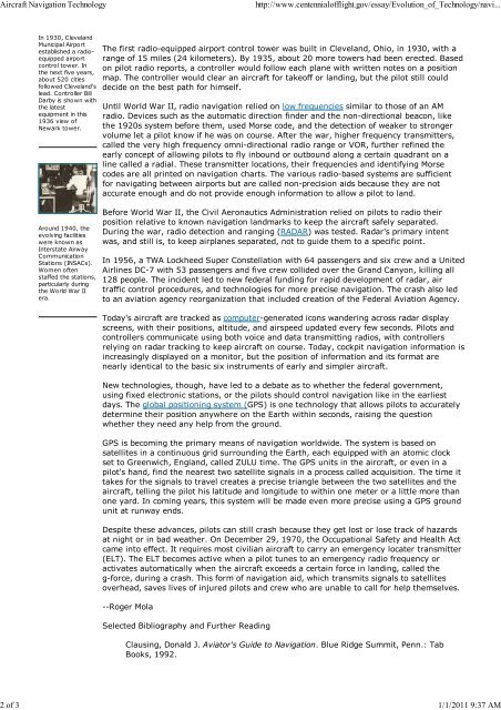
<strong>Aircraft</strong> <strong>Navigation</strong> <strong>Technology</strong>http://www.centennialofflight.gov/essay/Evolution_of_<strong>Technology</strong>/navi...2 of 3 1/1/2011 9:37 AMIn 1930, ClevelandMunicipal Airportestablished a radioequippedairportcontrol tower. Inthe next five years,about 520 citiesfollowed Cleveland'slead. Controller BillDarby is shown withthe latestequipment in this1936 view ofNewark tower.Around 1940, theevolving facilitieswere known asInterstate AirwayCommunicationStations (INSACs).Women oftenstaffed the stations,particularly duringthe World War IIera.The first radio-equipped airport control tower was built in Cleveland, Ohio, in 1930, with arange of 15 miles (24 kilometers). By 1935, about 20 more towers had been erected. Basedon pilot radio reports, a controller would follow each plane with written notes on a positionmap. The controller would clear an aircraft for takeoff or landing, but the pilot still coulddecide on the best path for himself.Until World War II, radio navigation relied on low frequencies similar to those of an AMradio. Devices such as the automatic direction finder and the non-directional beacon, likethe 1920s system before them, used Morse code, and the detection of weaker to strongervolume let a pilot know if he was on course. After the war, higher frequency transmitters,called the very high frequency omni-directional radio range or VOR, further refined theearly concept of allowing pilots to fly inbound or outbound along a certain quadrant on aline called a radial. These transmitter locations, their frequencies and identifying Morsecodes are all printed on navigation charts. The various radio-based systems are sufficientfor navigating between airports but are called non-precision aids because they are notaccurate enough and do not provide enough information to allow a pilot to land.Before World War II, the Civil Aeronautics Administration relied on pilots to radio theirposition relative to known navigation landmarks to keep the aircraft safely separated.During the war, radio detection and ranging (RADAR) was tested. Radar's primary intentwas, and still is, to keep airplanes separated, not to guide them to a specific point.In 1956, a TWA Lockheed Super Constellation with 64 passengers and six crew and a UnitedAirlines DC-7 with 53 passengers and five crew collided over the Grand Canyon, killing all128 people. The incident led to new federal funding for rapid development of radar, airtraffic control procedures, and technologies for more precise navigation. The crash also ledto an aviation agency reorganization that included creation of the Federal Aviation Agency.Today's aircraft are tracked as computer-generated icons wandering across radar displayscreens, with their positions, altitude, and airspeed updated every few seconds. Pilots andcontrollers communicate using both voice and data transmitting radios, with controllersrelying on radar tracking to keep aircraft on course. Today, cockpit navigation information isincreasingly displayed on a monitor, but the position of information and its format arenearly identical to the basic six instruments of early and simpler aircraft.New technologies, though, have led to a debate as to whether the federal government,using fixed electronic stations, or the pilots should control navigation like in the earliestdays. The global positioning system (GPS) is one technology that allows pilots to accuratelydetermine their position anywhere on the Earth within seconds, raising the questionwhether they need any help from the ground.GPS is becoming the primary means of navigation worldwide. The system is based onsatellites in a continuous grid surrounding the Earth, each equipped with an atomic clockset to Greenwich, England, called ZULU time. The GPS units in the aircraft, or even in apilot's hand, find the nearest two satellite signals in a process called acquisition. The time ittakes for the signals to travel creates a precise triangle between the two satellites and theaircraft, telling the pilot his latitude and longitude to within one meter or a little more thanone yard. In coming years, this system will be made even more precise using a GPS groundunit at runway ends.Despite these advances, pilots can still crash because they get lost or lose track of hazardsat night or in bad weather. On December 29, 1970, the Occupational Safety and Health Actcame into effect. It requires most civilian aircraft to carry an emergency locater transmitter(ELT). The ELT becomes active when a pilot tunes to an emergency radio frequency oractivates automatically when the aircraft exceeds a certain force in landing, called theg-force, during a crash. This form of navigation aid, which transmits signals to satellitesoverhead, saves lives of injured pilots and crew who are unable to call for help themselves.--Roger MolaSelected Bibliography and Further ReadingClausing, Donald J. Aviator's Guide to <strong>Navigation</strong>. Blue Ridge Summit, Penn.: TabBooks, 1992.
![p density of fluid, kg/m3 [Greek letter rho] V mean velocity of fluid, m ...](https://img.yumpu.com/50595898/1/184x260/p-density-of-fluid-kg-m3-greek-letter-rho-v-mean-velocity-of-fluid-m-.jpg?quality=85)