Aircraft Navigation Technology
Aircraft Navigation Technology
Aircraft Navigation Technology

You also want an ePaper? Increase the reach of your titles
YUMPU automatically turns print PDFs into web optimized ePapers that Google loves.
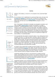
<strong>Aircraft</strong> <strong>Navigation</strong> <strong>Technology</strong>http://www.centennialofflight.gov/essay/Evolution_of_<strong>Technology</strong>/navi...1 of 3 1/1/2011 9:37 AM<strong>Aircraft</strong> <strong>Navigation</strong> <strong>Technology</strong>The SperryMessenger airplanehad gyroscopicequipment installedin its fuselagesection to controlits attitude anddirection of flight.Later refinements ofgyro controls led tothe development ofairplane autopilots.The interior of theAirway RadioStation at Portland,Oregon, about1929. CarlAnderson examinesa strip of the codein which the stationoperators mademost of theirtransmissions duringthis period.The St. Louis AirwayRadio Station duringthe late 1920s orearly 1930s isshown. Barelyvisible in the photois the wire strungbetween the tops ofits twin antennatowers. During thisera, some stationswere making hourlyweatherbroadcasts.Early pilots looked out of their open cockpits for roads, rail lines, and airports to find theirway in daytime flight. Pilots watched the horizon to make sure they were flying with theaircraft's nose and wings in the proper position relative to the ground, called attitude. Asairmail pilots began flying at night and in all kinds of weather in the early 1920s, newequipment helped pilots navigate and maintain aircraft attitude when they could not see theground. <strong>Navigation</strong> aids were developed for use inside the aircraft and also to guide thepilots from the ground.Simple equipment to help pilots maintain attitude was introduced during the 1920s. Thesedevices included such ideas as a bubble of liquid to help keep wings level and a device thatmeasured pressure at different heights, called an altimeter, that told a pilot his altitudeabove ground level. A simple magnetic compass for direction was installed either in thecockpit panel or held in the pilot's hand.In 1929, Lawrence Sperry and his Gyroscope Company introduced important newtechnology—the Artificial Horizon—that operated on gyroscopic principles. With its sensitiveattachments, Sperry's device could detect forces that upset the gyroscope's stable spin, thenwould activate the aircraft controls to maintain proper attitude while flying when visibleflight was not possible.In the 1930s, new mechanical aids emerged, some based on Sperry's gyroscope and othersbased on the rush of air through intakes under the wing or the aircraft belly to measurespeed and altitude. Equipment outside the aircraft measured the velocity of the air as itentered one intake and exited another. The results were fed to the pilot to help himdetermine the aircraft's attitude and position.<strong>Navigation</strong> information was displayed on a group of instruments called the basic or primarysix, which included the attitude indicator, a vertical speed indicator showing the rate ofclimb and descent, airspeed indicator, turn-and-bank coordinator, a heading indicatorshowing the magnetic compass course, and the altimeter. These instruments are still used.Refined versions of Sperry's invention appear in 2001 as the Inertial <strong>Navigation</strong> System(INS) and the Inertial Guidance System (IGS). These systems measure changes in theaircraft's location and attitude that have taken place since the aircraft left the ground.These new devices include an accelerometer to detect changes in airspeed as well asattitude. By determining the precise latitude and longitude before flight, then trackingevery change in location, the INS or IGS tells the pilot where he has flown.Radio navigation aids were developed around the same time as mechanical aids. In 1926,successful two-way radio air-to-ground communication began, and the firsttransmitter/receiver went into mass production in 1928. Teletype machines were installedso that all stations along an air route could transmit weather conditions to the pilot.Eventually the pilot used these stations to indicate the plane's location.The earliest radio navigation aid was the four-course radio range, which began in 1929.Four towers set in a square transmitted the letters A and N in Morse code. A pilot flyingalong one of the four beams toward the square would hear only an A or N in the dashes anddots of the code. The dashes and dots grew louder or more faint as he flew, depending if hewas flying toward or away from one of the corners. Turning right or left, he would soon heara different letter being transmitted, telling him which quadrant he had entered.The beams flared out, so that at certain points they overlapped. Where the A or N signalsmeshed, the Morse code dashes and dots sounded a steady hum, painting an audio roadwayfor the pilot. At least 90 such stations were in place by 1933, about 200 miles (322kilometers) apart along the 18,000-mile (28,968-kilometer) system of lighted towers androtating beacons. Unfortunately, mountains, mineral deposits, railroad tracks, and even theatmospheric disturbance of the setting sun could distort the signals.
<strong>Aircraft</strong> <strong>Navigation</strong> <strong>Technology</strong>http://www.centennialofflight.gov/essay/Evolution_of_<strong>Technology</strong>/navi...2 of 3 1/1/2011 9:37 AMIn 1930, ClevelandMunicipal Airportestablished a radioequippedairportcontrol tower. Inthe next five years,about 520 citiesfollowed Cleveland'slead. Controller BillDarby is shown withthe latestequipment in this1936 view ofNewark tower.Around 1940, theevolving facilitieswere known asInterstate AirwayCommunicationStations (INSACs).Women oftenstaffed the stations,particularly duringthe World War IIera.The first radio-equipped airport control tower was built in Cleveland, Ohio, in 1930, with arange of 15 miles (24 kilometers). By 1935, about 20 more towers had been erected. Basedon pilot radio reports, a controller would follow each plane with written notes on a positionmap. The controller would clear an aircraft for takeoff or landing, but the pilot still coulddecide on the best path for himself.Until World War II, radio navigation relied on low frequencies similar to those of an AMradio. Devices such as the automatic direction finder and the non-directional beacon, likethe 1920s system before them, used Morse code, and the detection of weaker to strongervolume let a pilot know if he was on course. After the war, higher frequency transmitters,called the very high frequency omni-directional radio range or VOR, further refined theearly concept of allowing pilots to fly inbound or outbound along a certain quadrant on aline called a radial. These transmitter locations, their frequencies and identifying Morsecodes are all printed on navigation charts. The various radio-based systems are sufficientfor navigating between airports but are called non-precision aids because they are notaccurate enough and do not provide enough information to allow a pilot to land.Before World War II, the Civil Aeronautics Administration relied on pilots to radio theirposition relative to known navigation landmarks to keep the aircraft safely separated.During the war, radio detection and ranging (RADAR) was tested. Radar's primary intentwas, and still is, to keep airplanes separated, not to guide them to a specific point.In 1956, a TWA Lockheed Super Constellation with 64 passengers and six crew and a UnitedAirlines DC-7 with 53 passengers and five crew collided over the Grand Canyon, killing all128 people. The incident led to new federal funding for rapid development of radar, airtraffic control procedures, and technologies for more precise navigation. The crash also ledto an aviation agency reorganization that included creation of the Federal Aviation Agency.Today's aircraft are tracked as computer-generated icons wandering across radar displayscreens, with their positions, altitude, and airspeed updated every few seconds. Pilots andcontrollers communicate using both voice and data transmitting radios, with controllersrelying on radar tracking to keep aircraft on course. Today, cockpit navigation information isincreasingly displayed on a monitor, but the position of information and its format arenearly identical to the basic six instruments of early and simpler aircraft.New technologies, though, have led to a debate as to whether the federal government,using fixed electronic stations, or the pilots should control navigation like in the earliestdays. The global positioning system (GPS) is one technology that allows pilots to accuratelydetermine their position anywhere on the Earth within seconds, raising the questionwhether they need any help from the ground.GPS is becoming the primary means of navigation worldwide. The system is based onsatellites in a continuous grid surrounding the Earth, each equipped with an atomic clockset to Greenwich, England, called ZULU time. The GPS units in the aircraft, or even in apilot's hand, find the nearest two satellite signals in a process called acquisition. The time ittakes for the signals to travel creates a precise triangle between the two satellites and theaircraft, telling the pilot his latitude and longitude to within one meter or a little more thanone yard. In coming years, this system will be made even more precise using a GPS groundunit at runway ends.Despite these advances, pilots can still crash because they get lost or lose track of hazardsat night or in bad weather. On December 29, 1970, the Occupational Safety and Health Actcame into effect. It requires most civilian aircraft to carry an emergency locater transmitter(ELT). The ELT becomes active when a pilot tunes to an emergency radio frequency oractivates automatically when the aircraft exceeds a certain force in landing, called theg-force, during a crash. This form of navigation aid, which transmits signals to satellitesoverhead, saves lives of injured pilots and crew who are unable to call for help themselves.--Roger MolaSelected Bibliography and Further ReadingClausing, Donald J. Aviator's Guide to <strong>Navigation</strong>. Blue Ridge Summit, Penn.: TabBooks, 1992.
<strong>Aircraft</strong> <strong>Navigation</strong> <strong>Technology</strong>http://www.centennialofflight.gov/essay/Evolution_of_<strong>Technology</strong>/navi...3 of 3 1/1/2011 9:37 AMIllman, Paul E. The Pilot's Air Traffic Control Handbook. Blue Ridge Summit, Penn.:Tab Books, 1993.Kershner, William K. The Student Pilot's Flight Manual. Ames, Iowa: Iowa StateUniversity Press, 1993.Spence, Charles F. Aeronautical Information Manual/Federal Aviation Regulations. NewYork: McGraw-Hill, 2000.U.S. Department of Transportation, Federal Aviation Administration. Pilot's Handbookof Aeronautical Knowledge. AC 61-23C. Washington, D.C.: Government PrintingOffice, 1997.On-Line References:Airports Council International. http://www.airports.orgEducational OrganizationInternational <strong>Technology</strong>Education AssociationInternational <strong>Technology</strong>Education AssociationStandard Designation(where applicable)Standard 4Standard 10Content of StandardStudents will develop anunderstanding of the social andeconomic effects of society.Students will develop anunderstanding of the role ofexperimentation and researchand development in problemsolving.Home | About Us | Calendar | Wright Brothers History | History of Flight | Sights & Sounds | Licensed Products | Education | Links | Sitemap
![p density of fluid, kg/m3 [Greek letter rho] V mean velocity of fluid, m ...](https://img.yumpu.com/50595898/1/184x260/p-density-of-fluid-kg-m3-greek-letter-rho-v-mean-velocity-of-fluid-m-.jpg?quality=85)