THE FUTURE OF THE AMAZON - Philip M. Fearnside - Inpa
THE FUTURE OF THE AMAZON - Philip M. Fearnside - Inpa
THE FUTURE OF THE AMAZON - Philip M. Fearnside - Inpa

Create successful ePaper yourself
Turn your PDF publications into a flip-book with our unique Google optimized e-Paper software.
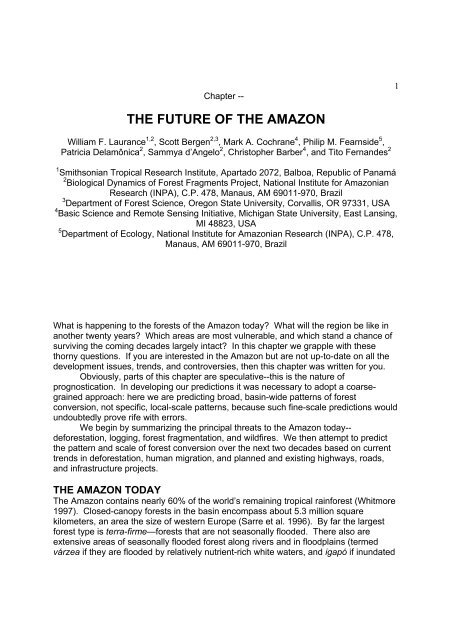
Chapter --1<strong>THE</strong> <strong>FUTURE</strong> <strong>OF</strong> <strong>THE</strong> <strong>AMAZON</strong>William F. Laurance 1,2 , Scott Bergen 2,3 , Mark A. Cochrane 4 , <strong>Philip</strong> M. <strong>Fearnside</strong> 5 ,Patricia Delamônica 2 , Sammya d’Angelo 2 , Christopher Barber 4 , and Tito Fernandes 21 Smithsonian Tropical Research Institute, Apartado 2072, Balboa, Republic of Panamá2 Biological Dynamics of Forest Fragments Project, National Institute for AmazonianResearch (INPA), C.P. 478, Manaus, AM 69011-970, Brazil3 Department of Forest Science, Oregon State University, Corvallis, OR 97331, USA4 Basic Science and Remote Sensing Initiative, Michigan State University, East Lansing,MI 48823, USA5 Department of Ecology, National Institute for Amazonian Research (INPA), C.P. 478,Manaus, AM 69011-970, BrazilWhat is happening to the forests of the Amazon today? What will the region be like inanother twenty years? Which areas are most vulnerable, and which stand a chance ofsurviving the coming decades largely intact? In this chapter we grapple with thesethorny questions. If you are interested in the Amazon but are not up-to-date on all thedevelopment issues, trends, and controversies, then this chapter was written for you.Obviously, parts of this chapter are speculative--this is the nature ofprognostication. In developing our predictions it was necessary to adopt a coarsegrainedapproach: here we are predicting broad, basin-wide patterns of forestconversion, not specific, local-scale patterns, because such fine-scale predictions wouldundoubtedly prove rife with errors.We begin by summarizing the principal threats to the Amazon today--deforestation, logging, forest fragmentation, and wildfires. We then attempt to predictthe pattern and scale of forest conversion over the next two decades based on currenttrends in deforestation, human migration, and planned and existing highways, roads,and infrastructure projects.<strong>THE</strong> <strong>AMAZON</strong> TODAYThe Amazon contains nearly 60% of the world’s remaining tropical rainforest (Whitmore1997). Closed-canopy forests in the basin encompass about 5.3 million squarekilometers, an area the size of western Europe (Sarre et al. 1996). By far the largestforest type is terra-firme—forests that are not seasonally flooded. There also areextensive areas of seasonally flooded forest along rivers and in floodplains (termedvárzea if they are flooded by relatively nutrient-rich white waters, and igapó if inundated
2by nutrient-poor black waters), and limited areas of bamboo forest and vine forest. Inaddition, there are scattered savannas and open forests in drier areas of the basin,where narrow strips of rainforest vegetation (termed “gallery forest”) often persist alongpermanent rivers and streams (IBGE 1997).Most of the Amazon is flat or undulating, occurs at low elevation (
370-75% of all deforestation in the Brazilian Amazon (<strong>Fearnside</strong> 1993, Nepstad et al.1999a), and account for much forest loss elsewhere in Latin America (e.g. Viña andCavalier 1999).The second major cause of deforestation is slash-and-burn farming, typicallyconducted by small landowners who clear small (1-2 ha) areas of forest each year. Theforest’s understory is slashed with machetes and the debris is ignited during the dryseason. The ash from the burned vegetation provides a brief pulse of plant nutrients,which supports crops for a few years before the area is left to fallow and the farmer isforced to clear more forest. Slash-and-burn farming occurs both opportunistically (oftenillegally) and as a result of government-sponsored colonization programs that allocatesmall forest tracts (50-200 ha) to individual families. Brazil has hundreds of Amazoniancolonization projects involving millions of people, initiated in part to help divertpopulation flows that would otherwise further overcrowd Brazil’s major cities (<strong>Fearnside</strong>1990, 1993).A third cause of deforestation, industrial agriculture, is increasing very rapidly inimportance along the drier southern margins of the Amazon (and also in drier areas inthe east-central Amazon near Santarem) and adjoining transitional forests and cerradowoodlands and savannas. Most of these farms are devoted to soybeans, whichinvolves clearing large expanses of flat land for crop production (<strong>Fearnside</strong> 2001,Steininger et al. 2001a, 2001b).LoggingIndustrial logging is increasing dramatically in the Amazon. Tropical logging is usuallyselective, in that only a small percentage of trees are harvested, although the number ofharvested species varies considerably among regions. In new Amazonian frontiers, forexample, only 5-15 species are typically harvested (1-3 trees/ha), but 100-150 speciesare harvested in older frontiers (5-10 trees/ha)(Uhl et al. 1997). Valuable timbers suchas mahogany (Swietenia spp.) are often overexploited and play a key role in makinglogging operations profitable (<strong>Fearnside</strong> 1997).The direct impacts of logging mostly arise from the networks of roads, tracks, andsmall clearings created during cutting operations (Fig. 2), which cause collateral treemortality, soil erosion and compaction, vine and grass invasions, and microclimaticchanges associated with disruption of the forest canopy (Uhl and Vieira 1989, Verissimoet al. 1992, 1995, Johns 1997). In addition, logging has important indirect effects; bycreating labyrinths of forest roads, logging opens up areas for colonization by migrantsettlers who often use destructive slash-and-burn farming methods (Uhl andBuschbacher 1985, Verissimo et al. 1995, Laurance 2001). Logging also allows a sharpincrease in hunting, which can dramatically affect some wildlife species. In theMalaysian state of Sarawak, for example, one logging camp was estimated to consumeover 30,000 kg of wildlife meat each year (Bennett and Gumal 2001).In recent years, multinational timber companies from Malaysia, Indonesia, SouthKorea, and other Asian countries have moved rapidly into the Brazilian Amazon bybuying large forest tracts, often obtained by purchasing interests in local timber firms. InGuyana, Suriname, and Bolivia, Asian corporations have obtained long-term forestleases (termed "concessions"; Colchester 1994, Sizer and Rice 1995). In 1996 alone,
4Asian companies invested more than $500 million in the Brazilian timber industry(Muggiati and Gondim 1996). Asian multinationals now control at least 13 million ha ofAmazonian forest (Laurance 1998).A striking feature of the Amazonian timber industry is that illegal logging isrampant. A 1997 study by the Brazilian government concluded that 80% of Amazonianlogging was illegal, and recent raids have netted massive stocks of stolen timber(Abramovitz 1998). Aside from widespread illegal cutting, most legal operations fromthe hundreds of domestic timber companies in the Amazon are poorly managed. Agovernment inspection of 34 operations in Paragominas, Brazil, for example, concludedthat "the results were a disaster," and that not one was using accepted practices to limitforest damage (Walker 1996). In a controversial effort to gain better control overlogging operations, in 1997 Brazil opened 39 of its National Forests (totaling 14 millionha) to logging, arguing that logging concessions would not be granted to companieswith poor environmental records (Anon. 1997). Much larger areas of the BrazilianAmazon are likely to be designated as logging reserves in the future (Verissimo et al.2002).Forest FragmentationThe rapid pace of deforestation is leading to widespread forest fragmentation. Habitatfragmentation has myriad effects on Amazonian forests, such as altering the diversityand composition of fragment biotas, and changing ecological processes like pollination,nutrient cycling, and carbon storage (Lovejoy et al. 1986, Bierregaard et al. 1992,Didham et al. 1996, Laurance and Bierregaard 1997, Laurance et al. 2002). Edgeeffects—ecological changes associated with the abrupt, artificial edges of forestfragments—penetrate at least 300 m into Amazonian forests (Laurance et al. 1997,1998a, 2000) and possibly much further (Skole and Tucker 1993, Laurance 2000).One key study found that by 1988, the area of forest in Brazilian Amazonia thatwas fragmented (
pattern has been likened to the ribs of a fish (Fig. 3).5WildfiresUnder natural conditions, large-scale fires are very rare in Amazonian rainforests,occurring only once or twice every thousand years during exceptionally severe El Niñodroughts (Sanford et al. 1985, Saldariagga and West 1986, Meggers 1994, Piperno andBecker 1996). (However, some drier Amazon forest formations, such as sandy-soilcampinaranas, apparently burned more frequently than did primary rainforest; B. W.Nelson, pers. comm.). Closed-canopy tropical forests are poorly adapted to fire (Uhland Kauffman 1990), and even light ground-fires can cause high tree mortality(Kauffman 1991, Barbosa and <strong>Fearnside</strong> 1999, Cochrane and Schulze 1999, Cochraneet al. 1999, Nepstad et al. 1999a).Fire is used commonly in the Amazon today, to clear forests, destroy slash piles,and help control weeds in pastures. Over a four-month period in 1997, satellite imagesrevealed nearly 45,000 separate fires in the Amazon (P. Brown 1998), virtually all ofthem human-caused. During drought years, smoke from forest burning becomes sobad that regional airports must be closed and hospitals report dramatic increases in theincidence of respiratory problems (Laurance 1998).Human land-uses dramatically increase the incidence of fire in tropical forests.Logged forests are far more susceptible to fires, especially during droughts. Loggingincreases forest desiccation and woody debris (Uhl and Kauffman 1990), and greatlyincreases access to slash-and-burn farmers and ranchers, which are the main sourcesof ignition (Uhl and Buschbacher 1985). The combination of logging, migrant farmers,and droughts are responsible for the massive fires that destroyed millions of hectares ofSoutheast Asian forests in 1982-83 and 1997-98 (Leighton 1986, Woods 1989, N.Brown 1998).Fragmented forests are also vulnerable to fire. This is because fragment edgesare prone to desiccation (Kapos 1989) and because forest remnants are juxtaposedwith fire-prone pastures, farmlands, and regrowth forests. Ground fires (Fig. 4)originating in nearby pastures can penetrate hundreds to thousands of meters intofragmented forests (Kauffman 1991, Cochrane and Laurance 2002). These lowintensityfires kill many trees and increase canopy openings and fuel loads, making theforest far more prone to catastrophic wildfires in the future (Cochrane et al. 1999,Cochrane and Schulze 1999). During the 1997/98 El Niño drought, wildfires lit byfarmers and ranchers swept through an estimated 3.4 million ha of fragmented andnatural forest, savanna, regrowth, and farmlands in the northern Amazonian state ofRoraima (Barbosa and <strong>Fearnside</strong> 1999), and there were many large fires in otherlocations (Cochrane and Schulze 1998).Available evidence suggests that there might be a “deforestation threshold”,above which landscapes become far more prone to fires. This could potentially occuras a result of positive feedbacks among deforestation, regional drying, smoke, and fire(Cochrane and Schulze 1999, Cochrane et al. 1999, Nepstad et al. 1999a,b, Lauranceand Williamson 2001). Amazonian forests recycle at least half of all rainfall back intothe atmosphere, helping to maintain frequent rains, lower surface temperatures, andmoderate dry seasons (Salati and Vose 1984). Regional deforestation can reduce
ainfall (IPCC 1996), making forests more fire prone and, in turn, promoting additionaldeforestation and fires. Smoke particles from fires further reduce rainfall by trappingmicrodroplets of water in the atmosphere, precluding the formation of raindrops(Rosenfeld 1999). Such positive feedbacks are most likely in the drier eastern,southern, and north-central areas of the Amazon, where rainforests are already neartheir physiological limits (Nepstad et al. 1998).6Ancillary ThreatsToday, even the remotest areas of the Amazon are being influenced by humanactivities. Illegal gold-mining is widespread, with wildcat miners polluting streams withmercury (used to separate gold from sediments) and degrading stream basins withpressure hoses. Illegal miners have also threatened indigenous Indians throughintimidation and introductions of new diseases (Christie 1997). In addition, there areincreasing numbers of major oil, natural gas, and mineral developments sanctioned byAmazonian governments (Nepstad et al. 1997, Laurance 1998). Finally, huntingpressure is growing throughout the Amazon because of greater access to forests andmarkets and the common use of shotguns (Peres 2001). Intensive hunting candramatically alter the structure of animal communities, extirpate species with lowreproductive rates, and exacerbate the effects of habitat fragmentation on exploitedspecies (Robinson and Redford 1991).<strong>FUTURE</strong> THREATS TO <strong>THE</strong> <strong>AMAZON</strong>Below we highlight several proximate and ultimate factors that will affect futuredevelopment trends in the Amazon. These relate mainly to projected changes inpopulation size, infrastructure development, and the spatial patterns of forestconversion (cf. Laurance et al. 2001b, 2001c).Population GrowthThe human population of the Amazon is increasing rapidly, for two reasons. First,populations are growing throughout Latin America, nearly tripling (from 166 to 448million) between 1950 and 1990 (Mahar and Schneider 1994). Although the traditionallyhigh fertility rates of Latin American women have declined in recent decades, themomentum of population growth will continue for some time because a large proportionof the population is young or still in their child-bearing years. In addition, Amazonianresidents often begin bearing children early--in their late teens or early twenties--whichcontributes substantially to rapid population growth.Second, there is much immigration into the Amazon. In Brazil, poor economicconditions and droughts in the northeast, limited opportunities in large cities, thedisplacement of agricultural workers by mechanized farming, and governmentcolonization programs designed to reduce urban overcrowding and help secure theAmazonian frontier have all contributed to a major influx of immigrants into the Amazon(<strong>Fearnside</strong> 1987, 1990, 1993). As a result of immigration and rapid growth, thepopulation of the Brazilian Amazon has increased twice as fast as the rest of Brazil,rising from 2 million in the 1960s to over 20 million today (Laurance et al. 2001a).
7Changing Patterns of DeforestationThe spatial patterns of Amazonian forest conversion are changing in alarming ways.Historically, large-scale deforestation has been most intensive in the eastern andsouthern areas of the Amazon (the “arc of deforestation”), in the Brazilian states ofPará, Maranhão, Rondônia, Acre, and Mato Grosso, and in northern Bolivia (Skole andTucker 1993). Since the 1960s, forest conversion has risen dramatically in these areasas a result of large-scale ranching, logging, international development projects,government-sponsored colonization schemes, mining, hydroelectric dams, and landspeculation (<strong>Fearnside</strong> 1987, 1990, 1995, Dale and Pearson 1997, Nepstad et al. 1997,Steininger et al. 2001a, 2001b). There also has been considerable forest clearing alongrivers and in parts of the northern and western Amazon--in Ecuador, Colombia, Peru,and Roraima (Brazil).But this picture is rapidly changing. Major new highways, roads, andtransportation projects are now dissecting the heart of the basin, providing access toareas once considered too remote for development. One of the most ambitious newhighways, BR-174, runs from the city of Manaus in central Amazonia, northward to theVenezuelan border, spanning a distance of over 1,000 km. Almost fully graded andpaved, it was initially promoted as a surgical cut through the forest to provide directaccess to Caribbean ports and markets in Venezuela. In 1997, however, BrazilianPresident Fernando Henrique Cardoso announced that 6 million ha of land along thehighway would be opened to settlement, and boasted that the area to be farmed wouldbe "so colossal that it would double the nation's agricultural production” (de Cassia1997). This highway is already promoting rapid forest clearing, especially within 100 kmof Manaus.As a result of logging booms and rapidly increasing development, central andnorthern Amazonian cities such as Manaus, Santarém, and Boa Vista are burgeoning.Ongoing construction to link Manaus to Rondônia in southern Amazonia by pavinghighway BR-319 will provide greatly increased access to the region for migrant settlers,and raises the alarming prospect that over the next decade Amazonian forests could bebisected by an expanding swath of deforestation and logging (Laurance 1998).New Infrastructure ProjectsAmazonian countries have ambitious, near-term plans to develop major infrastructureprojects encompassing large expanses of the basin. These projects are intended toaccelerate economic development and exports, especially in the agriculture, timber, andmining sectors of the economy. In the Brazilian Amazon, massive investments, on theorder of $40 billion in the years 2000-2007, are being implemented to fast-trackconstruction of dozens of major infrastructure projects—highways, railroads, gas lines,hydroelectric projects, power lines, and river-channelization projects (Anon. 1999,Avança Brasil 1999). The Amazonian road network is being rapidly expanded andupgraded, with many unpaved sections being converted to paved, all-weatherhighways. Key environmental agencies, such as the Ministry of the Environment, arebeing largely excluded from the planning of these developments (Laurance and<strong>Fearnside</strong> 1999, Laurance et al. 2001b).One indicator of the scale of planned development is the rapidly expanding
8network of hydroelectric dams. At least 19 major (100-13,000 megawatt) dams areplanned in the Brazilian Amazon over the next 10-20 years, nearly all in forested areas(Eletrobrás 1998). These new dams will vastly increase the 600,000 ha of forest that iscurrently inundated by reservoirs (because the region is quite flat, Amazonianhydroelectric reservoirs are often very large; <strong>Fearnside</strong> 1995). Most of these dam sitesare in tributaries flowing northward into the Amazon River from Brazil’s central plateau(the Tocantins, Araguaia, Xingu, and Tapajós Rivers), a region with a highconcentration of indigenous peoples (<strong>Fearnside</strong> 1990). In addition to destroying forestsand degrading aquatic systems, hydroelectric dams require networks of access roadsand power-line clearings, which promote further forest loss and fragmentation.New infrastructure projects will dissect vast expanses of the Amazon. The onceremotenorthern Amazon, for example, has been bisected by the BR-174 highway fromManaus to Venezuela, and will soon be cut by a road link between the rapidly growingcity of Boa Vista and Guyana and by a major power-line corridor linking Guri Dam inVenezuela with Boa Vista. These projects will affect large expanses of forest and manyindigenous groups in the northern Amazon (Soltani and Osborne 1994), and will greatlyincrease access to the region for loggers, ranchers, miners, and colonists.Other projects are equally ambitious. When completed, the massive FerronorteRailway will be the largest transportation project in Brazil, traversing over 4,000 km ofAmazonian forest while linking the cities of Santarém (along the Amazon River) andPorto Velho (in Rondônia) to those in southern Brazil. In the central and easternAmazon, permanent waterways are being constructed that involve channelizing theMadeira, Tocantins, and Araquaia Rivers, in order to allow deep-water river barges totransport soybeans from rapidly expanding agricultural areas in central Brazil (<strong>Fearnside</strong>2001). In the southern Amazon, planned road projects will traverse large expanses offorest and ascend the Andes to reach the Pacific coast, passing through Bolivia, Peru,and northern Chile. In addition, a 3000-km natural gas line currently under constructionwill run from Santa Cruz, Bolivia to São Paulo, Brazil (Soltani and Osborne 1994).Logging and Mining BoomsIncreasingly, logging and mining activities are becoming important driving forces in theexploitation of the Amazonian frontier. Timber, petroleum, natural gas, and mineralresources (iron ore, bauxite, gold, copper; Sarre et al. 1996) provide the economicimpetus for construction of roads, highways, and transportation networks, which greatlyincrease access to forests for colonists, ranchers, and land speculators. Roads createdfor oil exploration and development in Amazonian Ecuador have caused a drasticincrease in forest colonization, land speculation, and commercial hunting (Holmes1996). Similar trends are likely in the Peruvian Amazon, much of which is currentlybeing opened for oil and gas concessions (Fig. 5). Logging operations also greatlyincrease access to frontier areas; it has been estimated that 10,000 to 15,000 km 2 offorest is being logged each year in the Brazilian Amazon alone, a figure nearly as largeas the area being deforested each year (Nepstad et al. 1999a,b).PREDICTING <strong>THE</strong> <strong>FUTURE</strong> <strong>OF</strong> <strong>THE</strong> BRAZILIAN <strong>AMAZON</strong>Here we attempt to predict the scale and pattern of Amazonian forest degradation over
9the next two decades. We confine our predictions to the Brazilian Legal Amazon,which comprises about two-thirds of the basin (ca. 4.9 million km 2 ), because accuratespatial data on deforestation, transportation networks, and planned infrastructureprojects for the other Amazonian and Guianan countries were very difficult to acquire ona consistent basis. Our analysis is based on a GIS (geographic information system)model that integrates spatial data on existing and planned development activities.GIS Data LayersTo develop our model, we used the best and most recent available information on forestcover, rivers, planned and existing roads and infrastructure projects, fire proneness offorests, logging and mining intensity, and various conservation units (Table 1). Principaldata sources for forest cover, current roads and highways, and conservation units were1:3,000,000- and 1:4,000,000-scale maps produced by Brazilian agencies andconservation organizations, augmented with remote-sensing (Landsat TM and JERS-1radar) images and personal knowledge. The maps and remote-sensing images wereproduced from 1995 to late 1999 (Table 1).Data on new highways and road upgrades and planned infrastructure projects(Fig. 6) were gleaned from recent sources, principally reports and internet dataprepared for international investors by Avança Brasil (1999), as well as the 1998-2007development plan for Eletrobrás (1998), Brazil’s federal electricity utility. The probabilityof forest fires was based on the map of Nepstad et al. (1998, 1999a), who integratedextensive data on forest cover, seasonal soil-water availability, recent fires, and loggingactivity, in order to predict areas of high, moderate, and low fire vulnerability during the1998 dry season. Maps of the estimated extent of logging (both legal and illegal),industrial mining, and illegal gold-mining were produced by IBAMA (Brazil’s nationalenvironmental agency) in 1998 (Table 1).The Brazilian Amazon has a variety of federal and state conservation units thatvary considerably in their degree of environmental protection. We identified 13 majortypes of reserves and parks, which we placed into three general categories (Table 2).“High-protection reserves” include National Parks, Ecological Stations, and EcologicalReserves, which nominally receive strong protection. Sanctioned activities in suchareas include research, education, and, often, recreation and tourism.“Moderate-protection reserves” include National Forests, Extractive Reserves,and Sustainable Development Reserves, among others, which may be legally subjectedto nominally “sustainable” levels of industrial logging, agriculture, livestock grazing,hunting, fishing, tourism, and extraction of non-timber products (e.g. rubber, fuelwood,fruits, seeds, fibers). Mining is usually prohibited, although illegal gold mining certainlyoccurs in some reserves (Table 2).The final category, “reserves with uncertain protection,” includes extensiveIndigenous Lands and Reserves that collectively comprise about 18% of the BrazilianLegal Amazon (Table 2). In some areas, these lands may be more effectively protectedthan National Parks, especially where Amerindians are territorial and repel illegalcolonists, loggers, and gold miners. In other areas, however--particularly whereAmerindians have frequent contact with outsiders--a corruption of traditional lifestylescan occur. In a number of cases, indigenous groups in Brazil have sold their timber to
10commercial loggers, permitted wildcat mining, overhunted wildlife, illegally clearedprotected lands, invaded national parks, impeded firefighters, and even assaultedgovernment inspectors attempting to control illegal logging (Redford and Stearman1993, Alvard et al. 1997, Margolis 2000). Hence, environmental protection inAmerindian lands is likely to be highly variable, and will tend to decline as contact withoutsiders increases.Buffer ZonesRoads and infrastructure projects promote forest degradation by greatly increasinghuman access, and in some cases (such as hydroelectric reservoirs) by destroyinglarge areas of forest directly. To predict the future impacts of planned roads andprojects, we assessed the past effects of existing highways and roads on primary-forestcover in the Amazon.To do this we overlayed the existing road network on the Landsat TM-basedPathfinder map of the Brazilian Amazon for 1992. Many of the region’s major highways(e.g. Belém-Brasília, Transamazon, BR-364) were constructed in the 1960s and 1970s,and thus had been in existence for 15-25 years by 1992--roughly comparable to the 20-year time-frame for our predictions. Initially, five “buffer zones” were created around allpaved highways (0-10, 11-25, 26-50, 51-75, and 76-100 km on each side of thehighway), and the percentage loss of primary-forest cover within each zone wasdetermined. This analysis was then repeated using the entire network of highways andunpaved roads. Clouds, cloud shadows, and rivers were removed from the analysis(
11category is “high-impact areas,” which are regions in which primary-forest cover islikely to be absent or markedly reduced, and heavily fragmented. Such areas are highlyvulnerable to edge effects, fires, logging, and overhunting, and are severely degradedecologically. “Moderate-impact areas” have mostly intact primary-forest cover (>85%)but contain localized forest clearings and some roads, and may be affected by logging,mining, hunting, and oil and gas exploration. “Low-impact areas” have nearly intactprimary-forest cover (>95%) but can experience illegal gold-mining, small-scale farming,hunting, hand-logging, and non-timber resource extraction (e.g. rubber-tapping).“Pristine areas” have fully intact primary-forest cover and are free from anthropogenicimpacts aside from limited hunting, fishing, and swidden farming by traditionalindigenous communities.The optimistic and non-optimistic scenarios differ in that the former assumes thathighways, roads, and infrastructure projects will generate more-localized effects, andthat conservation areas will be less prone to disturbances (Table 3). The sizes of bufferzones used in the models were necessarily somewhat arbitrary, but have an empiricalbasis in our analyses of past deforestation. In the non-optimistic scenario, for example,we assumed that paved highways would create a 50 km-wide zone of heavily degradedforests on each side (Table 3), because our analysis suggested that these areasaveraged
12Results of the AnalysesThe optimistic scenario (Fig. 8) suggests that by the year 2020 there will be continueddeforestation in the southern and eastern portions of the Brazilian Amazon, andconsiderable large-scale fragmentation of forests in the central and southern parts ofthe basin. The Brazilian Amazon will be nearly bisected by heavily to moderatelydegraded areas along a north-south axis running from Rondônia to Manaus andnorthward to Venezuela. Pristine and lightly degraded forests will be fragmented intoseveral blocks, with the largest tract surviving in the western Brazilian Amazon.According to this scenario, pristine forests will comprise just 28.0% of the region, withlightly degraded forests comprising another 28.0%. Almost 27% of the region will bedeforested or heavily degraded (Fig. 9).The non-optimistic scenario (Fig. 8) projects an even more dramatic loss offorests along the southern and eastern areas of the basin. Large-scale fragmentation isalso more extensive, with much forest in the central, northern, and southeastern areaspersisting only in isolated tracts. The basin is almost completely bisected by a swath ofheavily degraded lands along the north-south axis running from Rondônia to Venezuela.There are very few areas of pristine forest aside from those in the western quarter ofthe region. This scenario predicts that pristine forests will comprise just 4.9% of theregion, with lightly degraded forests comprising another 25.4%. Over 40% of the regionwill be heavily degraded (Fig. 9).Discussion and ImplicationsBoth of our models suggest that the Brazilian Amazon will be drastically altered bycurrent development plans and prevailing land-use trends over the next twenty years.The principal difference between the models is in the extent of forest loss andfragmentation (Fig. 8) and relative proportions of heavily degraded versus pristineforests (Fig. 9).Some degree of oversimplification in our models was inevitable. For example,we did not incorporate the effect of population density into our models, in part becausewe observed that local road density in the Amazon seemed to be a reasonably goodsurrogate for local population density. It is also apparent that the buffer zones aroundroads, highways, and infrastructure projects will be more variable spatially than isindicated in our models. While we have incorporated many of the factors that are likelyto influence local deforestation (e.g. distance to roads, road quality [paved vs. unpaved],presence and type of protected areas, vulnerability to forest fires, logging and miningactivity), it is impossible to include every potentially relevant factor (cf. Laurance et al.2002 for further analyses of factors that influence Amazonian deforestation).The optimistic and non-optimistic scenarios vary considerably (Fig. 8), and it istherefore important to ask which is the most realistic. At least two considerationssuggest that the non-optimistic scenario may better approximate reality. First, the nonoptimisticmodel realistically assumes that forests with high fire vulnerability will becomeheavily degraded, while those of moderate vulnerability will become moderatelydegraded. The model of fire vulnerability we used (Nepstad et al. 1998) was producedfor a normal dry season and is therefore conservative, in the sense that much largerareas of the Amazon will become prone to fires during periodic El Niño droughts
13(Nepstad et al. 1998, Cochrane and Schulze 1998, 1999).Second, the non-optimistic model assumes that protected areas within 50 km ofhighways and roads will be lightly to moderately degraded. In fact, many protectedareas in the Amazon are little more than “paper parks” with inadequate protection.Ferreira et al. (1999) evaluated 86 federal parks and protected areas in Brazil and foundthat 43% were at high to extreme risk because of illegal deforestation, colonization,hunting, isolation of the reserve from other forest areas, and additional forms ofencroachment. More than half of all reserves (54.6%) were judged to have nearly nonexistentmanagement. For some reserves, even our non-optimistic model may beoverly optimistic.The fates of Amerindian lands will have an important impact on forestconservation, because they currently encompass some 18% of the Brazilian LegalAmazon (and about 21% of the forested area of the region). In many areas, the qualityof environmental protection as well as traditional lifestyles have declined markedly asindigenous groups come into more frequent contact with outsiders (Margolis 2000). Inthis sense, reducing construction of new roads and highways near indigenous landsmay be one of the most effective measures to ensure that traditional managementsystems are not corrupted.Other investigators have also attempted to predict spatial patterns of Amazoniandeforestation. Recent studies by a Brazilian non-governmental organization haveattempted to predict the extent of deforestation that will be caused by new highwayconstruction under the Avança Brasil program (Nepstad et al. 2000, 2001, Carvalho etal. 2001), but did not consider the effects of other infrastructure projects (hydroelectricreservoirs, power lines, gas lines, railroads, river-channelization projects, and theirassociated road networks) on forests (cf. <strong>Fearnside</strong> 2002). In addition, an ongoingstudy by C. Souza Jr. (pers. comm.) is using data on existing road networks, logging,and recent fires in order to assess conversion pressure on Brazilian Amazonian forests.Earlier studies, such as those of Kangas (1990) and Bryant et al. (1997), did notincorporate effects of massive planned highway and infrastructure developments underAvança Brasil, and hence are seriously out of date.Obviously, our models illustrate but two of a potentially infinite number ofpossible futures for the Brazilian Amazon. While we believe our approach is based onrealistic assumptions, it has two limitations. First, our model predictions (Fig. 8) aresomewhat difficult to test and verify, especially for lightly degraded forests. Lowintensityselective logging and illegal gold mining, for example, are nearly impossible todetect with remote sensing, although technological improvements could change this inthe future. Second, our models rely on specific assumptions about the future drivers offorest degradation (Table 3). Perhaps the most crucial assumption is that currentinfrastructure projects will proceed as planned and that there will be no major newdevelopment initiatives. The unforeseen construction of a new highway, for example,could alter the scale and spatial pattern of forest degradation, reducing the accuracy ofour predictions.In the Amazon, hundreds of millions of dollars are currently being expended onefforts to promote conservation planning, via international programs such as the PilotProgram to Protect the Brazilian Rainforest, bilateral initiatives, and the activities of non-
14governmental organizations (Laurance and <strong>Fearnside</strong> 1999; Laurance et al. 2001b).The most important conclusion of our study is that current domestic and internationalefforts to promote conservation planning in the Brazilian Amazon are likely to beswamped by near-term plans to invest over US$40 billion in Amazonian transportationand infrastructure projects. The environmental impacts are further magnified bypopulation increases, forest colonization projects, and rapidly expanding logging andmining industries. If our models provide even a rough approximation of the future, theforests of the Amazon will be profoundly altered over the next two decades. Weconclude that a fundamental reevaluation of criteria used in selecting, planning, andlicensing large-scale development projects is urgently needed (cf. <strong>Fearnside</strong> 2002).Without major policy changes, current development schemes are likely to have direeffects on Amazonian forests.ACKNOWLEDGEMENTSWe thank Bruce Nelson, Heraldo Vasconcelos, and Rita Mesquita for discussion andreviewing the manuscript. Support was provided by NASA-LBA program, Andrew W.Mellon Foundation, World Wildlife Fund-U.S., MacArthur Foundation, National Institutefor Amazonian Research, and the Smithsonian Institution. This is publication number316 in the BDFFP technical series.LITERATURE CITEDAbramovitz, J. 1998. Taking a stand: cultivating a new relationship with the world'sforests. World Watch Institute, Washington, D.C.Alvard, M. S., J. G. Robinson, K. H. Redford, and H. Kapland. 1997. The sustainabilityof subsistence hunting in the neotropics. Conservation Biology 11:977-982.Anon. 1997. Controle sobre florestas exige a reforma do IBAMA. A CríticaNewspaper, Manaus, Brazil, 19 January 1997.Anon. 1999. O debate sobre políticas públicas para Amazônia na imprensabrasileira, Vol. IV. Friends of the Earth, Amazonia Program, Brasília, Brazil.Avança Brasil. 1999. Avança Brasil: development structures for investment. Ministryfor Development, Industry, and Foreign Trade, Brasília, Brazil.Barbosa, R. I., and P.M. <strong>Fearnside</strong>. 1999. Incêndios na Amazônia brasileira:estimativa da emissão de gases do efeito estufa pela queima de diferentesecossistemas de Roraima na passagem do evento "El Niño" (1997/98). ActaAmazonica 29:513-534.Bennett, E. L., and M. T. Gumal. 2001. The interrelationships of commercial logging,hunting, and wildlife in Sarawak: recommendations for forest management.Pages 359-274 in R. Fimbel, A. Grajal, and J. G. Robinson, editors. The cuttingedge: conserving wildlife in logged tropical forests. Columbia University Press,New York.Bierregaard, R. O., Jr., T. E. Lovejoy, V. Kapos, A. dos Santos, and R. W. Hutchings.1992. The biological dynamics of tropical rainforest fragments. Bioscience42:859-866.Borges, S. H., M. Pinheiro, A. Murchie, and C. Durigan. 2001. Preservação do RioNegro: As unidades de conservação. Pages 303-329 in A. Oliveira and D. Daly,
15editors. As florestas do Rio Negro. Universidade Paulista Press, São Paulo,Brazil.Brown, K. S. 1987. Soils and vegetation. Pages 19-45 in T. C. Whitmore and G. T.Prance, editors. Biogeography and Quaternary history in tropical America.Oxford Monographs in Biogeography 3, Oxford, England.Brown, N. 1998. Out of control: fires and forestry in Indonesia. Trends in Ecology andEvolution 13:41.Brown, P. 1998. Forest fires: setting the world ablaze. The Guardian, London,England, 20 March 1998.Bryant, D., D. Nielsen, and L. Tangley. 1997. The last frontier forests: ecosystems andeconomies on the edge. World Resources Institute, Washington, D.C.Carvalho, G., A. C. Barros, P. Moutinho, and D. C. Nepstad. 2001. Sensitivedevelopment could protect the Amazon instead of destroying it. Nature 409:131.Cassia, de, R. 1997. BR-174: FHC anuncia abertura de nova fronteira agrícola noNorte. Amazonas em Tempo, Manaus, Brazil, p. A-4, 25 June 1997.Christie, M. 1997. Yanomami Indians appeal for help against invaders. ReutersNews Service, 31 August 1997.Cochrane, M. A., A. Alencar, M. D. Schulze, C. M. Souza, D. C. Nepstad, P. Lefebvre,and E. Davidson. 1999. Positive feedbacks in the fire dynamics of closedcanopy tropical forests. Science 284:1832-1835.Cochrane, M. A., and W. F. Laurance. 2002. Fire as a large-scale edge effect inAmazonian forests. Journal of Tropical Ecology 18:311-325.Cochrane, M. A., and M. D. Schulze. 1998. Forest fires in the Brazilian Amazon.Conservation Biology 12:948-950.Cochrane, M. A., and M. D. Schulze. 1999. Fire as a recurrent event in tropical forestsof the eastern Amazon: effects on forest structure, biomass, and speciescomposition. Biotropica 31:2-16.Colchester, M. 1994. The new sultans: Asian loggers move in on Guyana's forests.The Ecologist 24:45-52.Dale, V. H., and Pearson, S. M. 1997. Quantifying habitat fragmentation due to landusechange in Amazonia. Pages 400-409 in W. F. Laurance and R. O.Bierregaard, editors. Tropical forest remnants: ecology, management, andconservation of fragmented communities. University of Chicago Press, Chicago,Illinois, USA.Didham, R. K., J. Ghazoul, N. E. Stork, and A. J. Davis. 1996. Insects in fragmentedforests: a functional approach. Trends in Ecology and Evolution 11:255-260.Eletrobrás. 1998. Eletrobrás: The ten-year expansion plan, 1998-2007. CentraisElétricas do Brasil, Rio de Janeiro, Brazil.ERDAS. 1998. Environmental research data analysis system. ERDAS, Atlanta,Georgia, USA.ESRI. 1999. Arc/Info 7.2.1. Environmental Systems Research Institute, Redlands,California, USA.<strong>Fearnside</strong>, P. M. 1987. Causes of deforestation in the Brazilian Amazon. Pages 37-61 in R. F. Dickinson, editor. The geophysiology of Amazonia: vegetation andclimate interactions. John Wiley, San Francisco, USA.
16<strong>Fearnside</strong>, P. M. 1990. Environmental destruction in the Amazon. Pages 179-225 inD. Goodman and A. Hall, editors. The future of Amazonia: destruction orsustainable development? MacMillan, London, England.<strong>Fearnside</strong>, P. M. 1993. Deforestation in the Brazilian Amazon: the effect ofpopulation and land tenure. Ambio 8:537-545.<strong>Fearnside</strong>, P. M. 1995. Hydroelectric dams in the Brazilian Amazon as sources of"greenhouse" gases. Environmental Conservation 22:7-19<strong>Fearnside</strong>, P. M. 1997. Protection of mahogany: a catalytic species in the destructionof rain forests in the American tropics. Environmental Conservation 24:303-306.<strong>Fearnside</strong>, P. M. 1999. Biodiversity as an environmental service in Brazil's Amazonianforests: risks, value and conservation. Environmental Conservation 26:305-321.<strong>Fearnside</strong>, P. M. 2001. Soybean cultivation as a threat to the environment in Brazil.Environmental Conservation 28:23-38.<strong>Fearnside</strong>, P. M. 2002. Avança Brasil: environmental and social consequences ofBrazil’s planned infrastructure in Amazonia. Environmental Management30:735-747.Ferreira, L. V., R. M. L. de Sá, R. Buschbacher, G. Batmanian, B. R. Bensuran, and K.L. Costa. 1999. Áreas protegidas ou espaços ameaçados? World Wide Fundfor Nature, Brasília, Brazil.Gascon, C., G. B. Williamson, and G. A. B. da Fonseca. 2000. Receding forest edgesand vanishing reserves. Science 288:1356-1358.Holmes, B. 1996. The low-impact road. New Scientist 151(2048):43.IBGE. 1997. Diagnóstico ambiental da Amazônia Legal. CD-ROM wtih GIS version ofRADAM maps. Brazilian Institute for Geography and Statistics (IBGE), Brasília,Brazil.INPE. 1996. Deforestation estimates in the Brazilian Amazon, 1992-1994. NationalInstitute for Space Research (INPE), São Jose dos Campos, Brazil.INPE. 1998. Deforestation estimates in the Brazilian Amazon, 1995-1997. NationalInstitute for Space Research (INPE), São Jose dos Campos, Brazil.INPE. 2000. Deforestation estimates in the Brazilian Amazon, 1998-1999. NationalInstitute for Space Research (INPE), São Jose dos Campos, Brazil.IPCC. 1996. Climate change 1995: impacts, adaptations and mitigation of climatechange: scientific technical analyses. Intergovernmental Panel on ClimateChange, Cambridge University Press, Cambridge, England.Johns, A. 1997. Timber production and biodiversity conservation in tropical rainForests. Cambridge University Press, Cambridge, England.Kapos, V. 1989. Effects of isolation on the water status of forest patches in theBrazilian Amazon. Journal of Tropical Ecology 5:173-185.Kangas, P. 1990. Deforestation and diversity of life zones in the Brazilian Amazon: amap analysis. Ecological Modeling 49:267-275.Kauffman, J. B. 1991. Survival by sprouting following fire in tropical forests of theeastern Amazon. Biotropica 23:219-224.Laurance, W. F. 1998. A crisis in the making: responses of Amazonian forests to landuse and climate change. Trends in Ecology and Evolution 13:411-415.Laurance, W. F. 2000. Do edge effects occur over large spatial scales? Trends in
17Ecology and Evolution 15:134-135.Laurance, W. F. 2001. Tropical logging and human invasions. Conservation Biology15:4-5.Laurance, W. F., and R. O. Bierregaard, Jr., editors. 1997. Tropical forest remnants:ecology, management and conservation of fragmented communities.University of Chicago Press, Chicago, Illinois, USA.Laurance, W. F., A. Albernaz, and C. Da Costa. 2001a. Is deforestation acceleratingin the Brazilian Amazon? Environmental Conservation 28:305-311.Laurance, W. F., A. K. M. Albernaz, G. Schroth, P. M. <strong>Fearnside</strong>, E. Ventincinque, andC. Da Costa. 2002. Predictors of deforestation in the Brazilian Amazon.Journal of Biogeography 29:737-748.Laurance, W. F., M. A. Cochrane, S. Bergen, P. M. <strong>Fearnside</strong>, P. Delamonica, C.Barber, S. D’Angelo, and T. Fernandes. 2001b. The future of the BrazilianAmazon. Science 291:438-439.Laurance, W. F., P. Delamonica, S. G. Laurance, H. Vasconcelos, and T. E. Lovejoy.2000. Rainforest fragmentation kills big trees. Nature 404:836.Laurance, W. F., and P. M. <strong>Fearnside</strong>. 1999. Amazon burning. Trends in Ecology andEvolution 14:457.Laurance, W. F., P. M. <strong>Fearnside</strong>, M. A. Cochrane, S. D’Angelo, S. Bergen, and P.Delamonica. 2001c. Development of the Brazilian Amazon. Science 292:1652-1654.Laurance, W. F., L. V. Ferreira, J. M. Rankin-de Merona, and S. G. Laurance. 1998a.Rain forest fragmentation and the dynamics of Amazonian tree communities.Ecology 79:2032-2040.Laurance, W. F., S. G. Laurance, and P. Delamonica. 1998b. Tropical forestfragmentation and greenhouse gas emissions. Forest Ecology and Management110:173-180.Laurance, W. F., S. G. Laurance, L. V. Ferreira, J. Rankin-de Merona, C. Gascon, andT. E. Lovejoy. 1997. Biomass collapse in Amazonian forest fragments. Science278:1117-1118.Laurance, W. F., T. E. Lovejoy, H. L. Vasconcelos, E. M. Bruna, R. K. Didham, P. C.Stouffer, C. Gascon, R. O. Bierregaard, S. G. Laurance, and E. Sampiao.2002. Ecosystem decay of Amazonian forest fragments: a 22-year investigation.Conservation Biology 16:605-618.Laurance, W. F., and G. B. Williamson. 2001. Positive feedbacks among forestfragmentation, drought, and climate change in the Amazon. ConservationBiology 15:1529-1535.Leighton, M. 1986. Catastrophic drought and fire in Borneo tropical rain forestassociated with the 1982-1983 El Niño Southern Oscillation Event. Pages 75-102 in G. T. Prance, editor. Tropical rain forests and the world atmosphere.Cambridge University Press, Cambridge, England.Lovejoy, T. E. 1999. Preface. Biological Conservation 91:100.Lovejoy, T. E., R. O. Bierregaard, A. Rylands, J. R. Malcolm, C. Quintela, L. Harper, K.Brown, A. Powell, G. Powell, H. Schubart, and M. Hays. 1986. Edge and othereffects of isolation on Amazon forest fragments. Pages 257-285 in M. E. Soule,
18editor. Conservation biology: the science of scarcity and diversity. Sinauer,Sunderland, Massachusetts, USA.Mahar, D., and R. Schneider. 1994. Incentives for tropical deforestation: someexamples from Latin America. Pages 159-171 in K. Brown and D. W. Pearce,editors. The causes of tropical deforestation: the economic and statisticalanalysis of factors giving rise to the loss of tropical forests. University CollegeLondon Press, London, England.Margolis, M. 2000. Not as green as they seem. Newsweek International, 27 March,pp. 10-14.Meggers, B. J. 1994. Archeological evidence for the impact of mega-Niño events onAmazonian during the past two millennia. Climatic Change 28:321-338.Muggiati, A. and A. Gondim. 1996. Madeireiras. O Estado de S. Paulo, São Paulo,Brazil, 16 September 1996.Nepstad, D. C., J. P. Capobianco, A. C. Barros, G. Carvalho, P. Moutinho, P. Lefebvre,and U. Lopes. 2000. Avança Brasil: cenários futuros para a Amazônia.Institute for Environmental Research in the Amazon (IPAM), Belém, Brazil.Nepstad, D. C., C. Carvalho, E. Davidson, P. Jipp, P. Lefebre, G. Negreiros, E. Silva, T.Stone, S. Trumbore, and S. Vieira. 1994. The role of deep roots in thehydrological cycles of Amazonian forests and pastures. Nature 372:666-669.Nepstad, D., G. Carvalho, A. Barros, A. Alencar, J. Capobianco, J. Bishop, P. Moutinho,P. Lefebvre, and U. Silva, Jr. 2001. Road paving, fire regime feedbacks, and thefuture of Amazon forests. Forest Ecology and Management 154:295-407.Nepstad, D. C., C. Klink, C. Uhl, I. Viera, P. LeFebvre, M. Pedlowski, E. Matricardi, G.Negreiros, I. Brown, E. Amaral, A. Homma, and R. Walker. 1997. Land-use inAmazonia and the cerrado of Brazil. Ciencia e Cultura 49:73-86.Nepstad, D. C., A. G. Moreira, and A. A. Alencar. 1999a. Flames in the rain forest:origins, impacts, and alternatives to Amazonian fires. Pilot Program to Conservethe Brazilian Rain Forest, Brasília, Brazil.Nepstad, D. C., A. Moreira, A. Verissimo, P. Lefebvre, P. Schlesinger, C. Potter, C.Nobre, A. Setzer, T. Krug, A. Barros, A. Alencar, and J. Pereira. 1998. Forestfire prediction and prevention in the Brazilian Amazon. Conservation Biology12:951-955.Nepstad, D. C., A. Verissimo, A. Alencar, C. Nobre, E. Lima, P. Lefebre, P.Schlesinger, C. Potter, P. Moutinho, E. Mendoza, M. Cochrane, and V. Brooks.1999b. Large-scale impoverishment of Amazonian forests by logging and fire.Nature 398:505-508.Olmos, F., A. P. Queiroz-Filho, and C. A. Lisboa. 1998. As unidades de conservaçãode Rondônia. Secretariate for Planning (SEPLAN), Rondônia, Brazil.Peres, C. A. 2001. Synergistic effects of subsistence hunting and habitatfragmentation on Amazonian forest vertebrates. Conservation Biology 15:1490-1505.Piperno, D. R., and P. Becker. 1996. Vegetational history of a site in the centralAmazon Basin derived from phytolith and charcoal records from naturalsoils. Quaternary Research 45:202-209.Redford, K. H., and A. M. Stearman. 1993. Forest-dwelling native Amazonians and the
19conservation of biodiversity. Conservation Biology 7:248-255.Richter, D. D., and L. I. Babbar. 1991. Soil diversity in the tropics. Advances inEcological Research 21:315-389.Robinson, J., and K. Redford, editors. 1991. Neotropical wildlife use andconservation. University of Chicago Press, Chicago, Illinois, USA.Rosenfeld, D. 1999. TRMM observed first direct evidence of smoke from forest firesinhibiting rainfall. Geophysical Research Letters 26:3105-3108.Rylands, A. B. 1991. The status of conservation areas in the Brazilian Amazon.World Wildlife Fund, Washington, D.C.Rylands, A. B., and L. P. Pinto. 1998. Conservação da biodiversidade na AmazôniaBrasiliera: uma análise do sistema de unidades de conservação. BrazilianFoundation for Sustainable Development, Brasília, Brazil.Salati, E. and P. B. Vose. 1984. Amazon basin: a system in equilibrium. Science225:129-138.Saldariagga, J., and D. C. West. 1986. Holocene fires in the northern Amazon basin.Quaternary Research 26:358-366.Sanford, R. L., J. Saldariagga, K. Clark, C. Uhl, and R. Herrera. 1985. Amazon rainforestfires. Science 227:53-55.Sarre, A., M. Sobral Filho, and M. Reis. 1996. The amazing Amazon. ITTO TropicalForest Update 6(4):3-7.Silva, L. L. 1996. Ecologia: manejo de áreas silvestres. Ministry of the Environment,Brasília, Brazil.Sizer, N., and R. Rice. 1995. Backs to the wall in Suriname: forest policy in a countryin crisis. World Resources Institute, Washington, D.C., USA.Skole, D., and C. J. Tucker. 1993. Tropical deforestation and habitat fragmentation inthe Amazon: satellite data from 1978 to 1988. Science 260:1905-1910.Soltani, A., and T. Osborne. 1994. Arteries for global trade, consequences forAmazonia. Amazon Watch, Malibu, California, USA.Steininger, M. K., C. Tucker, P. Ersts, T. Killeen, and S. Hecht. 2001a. Clearance andfragmentation of semi-deciduous tropical forest in the Tierras Bajas zone, SantaCruz, Bolivia. Conservation Biology 15:856-866.Steininger, M. K., C. Tucker, J. Townshend, V. Bell, A. Desch, P. Ersts, and T. Killeen.2001b. Tropical Deforestation in the Bolivian Amazon. EnvironmentalConservation 28:127-134.Stone, T., and P. Lefebvre. 1998. Using multi-temporal satellite data to evaluateselective logging in Pará, Brazil. International Journal of Remote Sensing19:2517-2526.Uhl, C., P. Barreto, A. Verissimo, E. Vidal, P. Amaral, A. C. Barros, C. Souza, J. Johns,and J. Gerwing. 1997. Natural resource management in the Brazilian Amazon.Bioscience 47:160-168.Uhl, C., and R. Buschbacher. 1985. A disturbing synergism between cattle ranchburning practices and selective tree harvesting in the eastern Amazon.Biotropica 17:265-268Uhl, C., and I. C. G. Vieira. 1989. Ecological impacts of selective logging in theBrazilian Amazon: a case study from the Paragominas region of the state of
20Pará. Biotropica 21:98-106.Uhl, C., and J. B. Kauffman. 1990. Deforestation, fire susceptibility, and potential treeresponses to fire in the eastern Amazon. Ecology 71:437-449.Veríssimo, A., P. Barreto, M. Mattos, R. Tarifa, and C. Uhl. 1992. Logging impacts andprospects for sustainable forest management in an old Amazonian frontier: thecase of Paragominas. Forest Ecology and Management 55:169-199.Verissimo, A., P. Barreto, R. Tarifa, and C. Uhl. 1995. Extraction of a high-valuenatural resource in Amazonia: the case of mahogany. Forest Ecology andManagement 72:39-60.Veríssimo, A., M. A. Cochrane, and C. Souza, Jr. 2002. National forests in theAmazon. Science 297:1478.Viña, A., and J. Cavalier. 1999. Deforestation rates (1938-1988) of tropical lowlandforests on the Andean foothills of Colombia. Biotropica 31:31-36.Walker, G. 1996. Kinder cuts. New Scientist 151(2048):40-42.Whitmore, T. C., 1997. Tropical forest disturbance, disappearance, and species loss.Pages 3-12 in W. F. Laurance and R. O. Bierregaard, editors. Tropical forestremnants: ecology, management, and conservation of fragmented communities.University of Chicago Press, Chicago, Illinois.Woods, P. 1989. Effects of logging, drought, and fire on tropical forests in Sabah,Malaysia. Biotropica 21:290-298.Table 1. Data layers used in analyses of land-use trends in Brazilian Amazonia.Infrastructure projects include railroads, hydroelectric reservoirs, power lines, gas lines,and river-channelization projects.
LayerCurrent forest cover and rivers21Data SourcesForest/non-forest coverage produced by the NationalOceanographic and Atmospheric Administrationbased on 1999 AVHRR imageryExisting highways (paved) and 1995 map of Brazilian Legal Amazon (1:3,000,000roads (unpaved)scale) produced by Brazilian Institute for Geographyand Statistics (IBGE); supplemented by 1999 map ofAmazonian protected areas (1:4,000,000 scale,Instituto Socioambiental, São Paulo, Brazil), JERS-1radar imagery for 1999, and personal knowledgePlanned roads and highways, Maps and information provided by the Avança Brasiland highway upgrades program (Avança Brasil 1999)Existing infrastructure projectsPlanned infrastructure projectsFire proneness of forestsLogging and mining activityFederal and state parks andreserves, national forests,extractive reserves, andindigenous lands and reserves1995 IBGE map of Brazilian Legal Amazon,supplemented by personal knowledgeMaps and information provided by Avança Brasil(1999), Eletrobrás (1998), and personal knowledgeMap of areas with high, medium, and low firevulnerability produced by Nepstad et al. (1998,1999b), based on analyses of forest cover, seasonalsoil moisture, logging activity, and recent fires duringthe 1998 dry season1998 map of estimated legal and illegal logging,wildcat gold mining, and industrial mining, producedby IBAMA, Brazil’s national environmental agency1995 IBGE map of Brazilian Legal Amazon,supplemented by 1999 map of Amazonian protectedareas and personal knowledgeTable 2. Legally permitted activities within conservation areas in the Brazilian Amazon 1 .Recreation AgricultureNon-timberType of Area & Tourism & Livestock Logging Harvests Hunting MiningAreas with nominally high protectionNational/State Parks Yes No No No No No
22Ecological Reserves Yes No No No NoNoBiological Reserves No No No No No NoEcological Stations No No No No No NoAreas with moderate protectionNational/State Forests Yes Yes Yes Yes Yes 2 NoNational Forest Res. Yes Yes Yes Yes Yes 2 NoExtractive Reserves Yes Yes Yes Yes Yes 2 NoState Extractive Forests Yes Yes Yes Yes Yes 2 NoSustainable Use Forests Yes Yes Yes Yes Yes 2 NoSustain. Devel. Reserves Yes Yes Yes Yes Yes 2 NoEnviron. Protection Areas Yes Yes 3 Yes 3 Yes 3 NoYes 3Areas of RelevantEcological Interest Yes Yes 3 No Yes 3 No NoAreas with uncertain protectionIndigenous Lands andReserves No Yes Yes Yes Yes No1 Data sources: Rylands (1991), Silva (1996), Olmos et al. (1998), Rylands and Pinto(1998), and Borges et al. (2001); internet websites of IBAMA, Instituto Socioambiental,and IBGE; and communication with Luciene Pohl of Brazil’s National Indian Foundation(FUNAI).2 Hunting is allowed in some areas; for others information was unavailable.3 These activities are not expressly permitted, but because people are allowed to live inthese reserves they will certainly occur, at least on a limited scale.Table 3. Explicit assumptions of “optimistic” and “non-optimistic” GIS models to predictthe future of the Brazilian Amazon.Optimistic Scenario Non-optimistic Scenario1) Degradation zones around paved highways (current and planned)Heavily degraded zone 0-25 km 0-50 km
Moderately degraded zone 25-50 km 50-100 kmLightly degraded zone 50-75 km 100-200 kmPristine zone >75 km >200 km232) Degradation zones around unpaved roads, railroads, power lines, gas lines, industrialmines, and river-channelization projects (current and planned)Heavily degraded zone 0-10 km 0-25 kmModerately degraded zone 10-25 km 25-50 kmLightly degraded zone 25-50 km 50-100 kmPristine zone >50 km >100 km3) Degradation zones around hydroelectric reservoirsHeavily degraded zone Area inundated Area inundatedModerately degraded zone 0-5 km 0-10 kmLightly degraded zone 5-10 km 10-25 kmPristine zone >10 km >25 km4) Degradation zones around major navigable rivers (>900 m wide)Heavily degraded zone 0-2 km 0-5 kmModerately degraded zone 2-5 km 5-10 kmLightly degraded zone 5-10 km 10-25 kmPristine zone >10 km >25 km5) Areas prone to logging Moderately degraded Mod. degraded6) Areas prone to wildcat mining Lightly degraded Lightly degraded7) Areas prone to firesHigh vulnerability Moderately degraded Heavily degradedModerate vulnerability Lightly degraded Mod. degraded8) Conservation areasHigh-protection areas outside buffers Pristine PristineHigh-protection areas inside buffers Pristine Lightly degradedMod.-protection areas outside buffers Lightly degraded Lightly degradedMod.-protection areas inside buffers Lightly degraded Mod. degradedIndigenous areas outside buffers Pristine Lightly degradedIndigenous areas inside buffers Lightly degraded Mod. DegradedFIGURE CAPTIONSFig. 1. Annual deforestation rates in the Brazilian Amazon during the decade of the1990s. The regression line shows the overall trend. These estimates do not includesmall clearings (
Fig. 3. Different land uses produce differing patterns of forest loss and fragmentation.A. Large-scale cattle ranching (near Paragominas, Pará). B. “Fishbone” deforestationpattern associated with forest-colonization projects (near Tailândia, Pará). Eachrectangle shows an area of 570 km 2 .Fig. 4. Low-intensity ground fires can penetrate considerable distances into forests,killing many trees making forests vulnerable to devastating wildfires in the future(photograph by M. A. Cochrane).Fig. 5. Much of the Peruvian Amazon is being opened up for oil and gas explorationand development. Shaded areas show current oil and gas concessions, mostly ownedby multinational corporations.24Fig. 6. Existing and planned highways and infrastructure projects in the BrazilianAmazon. Above: highways and roads. Below: major infrastructure projects (“utilities”are gas lines and power lines, while “channels” are river-channelization projects).Fig. 7. Percentage of closed-canopy forest destroyed by 1992 as a function of distancefrom paved highways, and from all roads and highways, in the Brazilian Amazon.Fig. 8. Above: optimistic scenario. Below: non-optimistic scenario. Both scenariosshow projected forest degradation in the Brazilian Amazon by the year 2020(gray=deforested or heavily degraded, including savannas and other non-forestedareas; crosshatched=moderately degraded; single hatched=lightly degraded;white=pristine).Fig. 9. Percentages of Brazilian Amazon forest in various degradation classesaccording to the optimistic and non-optimistic scenarios.