ws5 marine weather satellite receiver system - ICS Electronics Ltd
ws5 marine weather satellite receiver system - ICS Electronics Ltd
ws5 marine weather satellite receiver system - ICS Electronics Ltd
- No tags were found...

You also want an ePaper? Increase the reach of your titles
YUMPU automatically turns print PDFs into web optimized ePapers that Google loves.
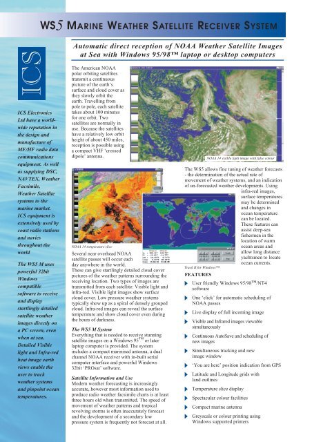
WS5 MARINE WEATHER SATELLITE RECEIVER SYSTEM<strong>ICS</strong><strong>ICS</strong> <strong>Electronics</strong><strong>Ltd</strong> have a worldwidereputation inthe design andmanufacture ofMF/HF radio datacommunicationsequipment. As wellas supplying DSC,NAVTEX, WeatherFacsimile,Weather Satellite<strong>system</strong>s to the<strong>marine</strong> market.<strong>ICS</strong> equipment isextensively used bycoast radio stationsand naviesthroughout theworldThe WS5 M usespowerful 32bitWindowscompatiblesoftware to receiveand displaystartlingly detailed<strong>satellite</strong> <strong>weather</strong>images directly ona PC screen, evenwhen at sea.Detailed Visiblelight and Infra-redheat image earthviews enable theuser to track<strong>weather</strong> <strong>system</strong>sand pinpoint oceantemperatures.Automatic direct reception of NOAA Weather Satellite Imagesat Sea with Windows 95/98 laptop or desktop computersThe American NOAApolar orbiting <strong>satellite</strong>stransmit a continuouspicture of the earth’ssurface and cloud cover asthey slowly orbit theearth. Travelling frompole to pole, each <strong>satellite</strong>takes about 100 minutesfor one orbit. Two<strong>satellite</strong>s are normally inuse. Because the <strong>satellite</strong>shave a relatively low orbitheight of about 450 miles,reception is possible usinga compact VHF ‘crosseddipole’ antenna.NOAA 14 temperature sliceSeveral near overhead NOAA<strong>satellite</strong> passes will occur eachday anywhere in the world.These can give startlingly detailed cloud coverpictures of the <strong>weather</strong> patterns surrounding thereceiving location. Two types of images aretransmitted from each <strong>satellite</strong>: Visible light andinfra-red. Visible light images show surfacecloud cover. Low pressure <strong>weather</strong> <strong>system</strong>stypically show up as a spiral of densely groupedcloud. Infra-red images can reveal the surfacetemperature and show cloud cover even duringthe hours of darkness.The WS5 M SystemEverything that is needed to receive stunning<strong>satellite</strong> images on a Windows 95 or laterlaptop computer is provided. The <strong>system</strong>includes a compact marinised antenna, a dualchannel NOAA <strong>receiver</strong> with in-built serialcomputer interface and powerful Windows32bit ‘PROsat’ software.Satellite Information and UseModern <strong>weather</strong> forecasting is increasinglyaccurate, however most information used toproduce radio <strong>weather</strong> facsimile charts is at leastthree hours old when transmitted. The speed ofmovement of <strong>weather</strong> patterns and tropicalrevolving storms is often inaccurately forecastand the development of a secondary lowpressure <strong>system</strong> is frequently not forecast at all.The WS5 allows fine tuning of <strong>weather</strong> forecasts- the determination of the actual rate ofmovement of <strong>weather</strong> <strong>system</strong>s, and an indicationof un-forecasted <strong>weather</strong> developments. Usinginfra-red images,surface temperaturesmay be determinedand changes inocean temperaturecan be located.These features canassist deep-seafishermen in thelocation of warmocean areas andallow long distanceyachtsmen to locateocean currents.Track II for WindowsFEATURES User friendly Windows 95/98/NT4softwareNOAA 14 visible light image with false colourOne ‘click’ for automatic scheduling ofNOAA passesLive display of full incoming imageVisible and Infrared images viewablesimultaneouslyContinuous AutoSave and scheduling ofnew imagesSimultaneous tracking and newimage window‘You are here’ position indication from GPSLatitude and Longitude grids withland outlinesTemperature slice displaySpectacular colour facilitiesCompact <strong>marine</strong> antennaGreyscale or colour printing usingWindows supported printers
Software OperationAs with all <strong>ICS</strong> products, ease of use is ofparamount importance. One click of the‘Automatic Reception Icon’ will start anew reception session. The ‘TrackingWindow’ will show the actual position ofthe ‘footprint’ of the NOAA <strong>satellite</strong>plotted on a world map. It shows details ofthe actual ‘rise’ and ‘fall times’ of the nextavailable <strong>satellite</strong>s. From then on, imagesare automatically received, dated, timestampedand saved to computer file. Themost up to date image is left in view.Previous images may be recalled and‘windowed’ alongside for comparison.Any part of an image may be enlarged andprocessed to provide maximum imageclarity. Images may be zoomed as many as threetimes, grey levels manipulated and imagecontrast adjusted to allow examination of the finedetail. User defined ‘false colour’ palettes may beoverlaid. These can enhance the overall imagepresentation by showing ocean areas and landmasses in different colours.The ‘Temperature Slice’ feature presents areasof similar surface temperatures as colouredbands. This permits the user to view the positionof <strong>weather</strong> fronts and ocean currents which canbe dependant on changes in surface temperature.Computer generated latitude and longitudegridding and country outlines may besuperimposed on the received image and the actualposition of the vessel can be plotted on the screen.By connecting the WS5 to a GPS navigation<strong>receiver</strong> with a NMEA 0183 interface, the vessel’sposition details and the computer’s clock may beautomatically updated.Satellite Element DataSatellite orbit prediction element data can be automaticallydown loaded into the WS5 by connectionto the “Internet” or telephone bulletin board(requires Windows supported modem). To maintainthe accuracy of the <strong>satellite</strong> rise time predictionand grid image overlay, updating is normallyrequired once a month. If a direct “Internet”connection is not available on board, it is possibleto enter the element update information by hand.<strong>ICS</strong>WS5 M Technical SpecificationsRECEIVERReceiver Frequency137.500, 137.620 MHzReceiver Sensitivity>0.3µV for 12dB SINADAntenna Input75Ω F type connector, 12v DC present.Supply Voltage10-14 Volts DCSupply Current500 mASerial Interface Output 57.6kbpsNMEA Input0183 Version 2 - RMC or GGA& ZDA or GLL&ZDASize200W x 45H x 15D mm excluding connectorsWeight0.45KgMountingTable top, or bulkhead using the BMK-2 optionCOMPUTER REQUIREMENTSPentium 90 or higher processor, 20MB hard disk space, Windows 95/98 or NT4, Unused serial COM port,8MB RAM or more, Super VGA 800x600x256 display or betterAutomatic update of NOAA <strong>satellite</strong> elements requires a modem and Internet accountWS5 - OPTIONS● BMK-2bulkhead or shelf mounting kit for WS5 <strong>receiver</strong>● WS-EXT20m antenna extension cable● WS-5GMeteosat & GOES Geostationary<strong>satellite</strong>-upgrade for WS5,(for landbased installation only)TECHNICAL DETAILS - WS-ANT/A ANTENNAMarinised cross dipole antenna with reflectors, 1” x 14 T.P.I.internal mounting thread, 10m plug in cableSize650mm tall x 950mm diameterWeight1.75Kg<strong>ICS</strong> <strong>Electronics</strong> has a policy of continuous product improvement and reserve the right to vary in detail from thespecifications contained in this brochure.WS5 M Rev B 24/08/1998 © 98 <strong>ICS</strong> <strong>Electronics</strong> <strong>Ltd</strong><strong>ICS</strong> <strong>Electronics</strong> <strong>Ltd</strong>,Unit V, Rudford Industrial Estate, Ford, Arundel, West Sussex BN18 0BD, England.Telephone: +44 (0) 1903 731101 Facsimile: +44 (0) 1903 731105Email: sales@icselectronics.co.uk Web Site: www.icselectronics.co.uk