Edexcel IGCSE Geography Chapter 1 - Pearson Schools
Edexcel IGCSE Geography Chapter 1 - Pearson Schools
Edexcel IGCSE Geography Chapter 1 - Pearson Schools

Create successful ePaper yourself
Turn your PDF publications into a flip-book with our unique Google optimized e-Paper software.
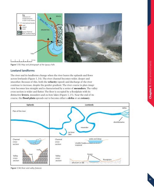
KeyDifference inheight betweenX and Y is 82 metresBRAZILNinternational borderroadairporthotelIguaçu NationalPark, southern BrazilIguaça RiverARGENTINAARGENTINAYIguaçuXFalls0 2 4 6 8 10 kmFigure 1.13: Map and photograph of the Iguaçu FallsLowland landformsThe river and its landforms change when the river leaves the uplands and flowsacross lowlands (Figure 1.14). The river channel becomes wider, deeper andsmoother. Because of this, both the velocity (speed) and discharge of the rivercontinue to increase, despite the gentler gradient. The river course in plan (map)view becomes less straight and is characterised by a series of meanders. The valleycross section is wider and flatter. The floor is occupied by a floodplain with itsdistinctive levees, meanders and ox-bow lakes (Figure 1.15). Near the end of itscourse, the flood plain spreads out to become either a delta or an estuary.<strong>Chapter</strong> 1: River environmentsPlan of the riverUplandsLowlandsdeltadistributariesmeanderox-bowlakeChannelcrosssectionChannelcrosssectionsmaller loadmaterialwide and deeprockValleycrosssectionriverValleycrosssectionalluvium or siltleveesfloodplainFigure 1.14: River and valley features11