Edexcel IGCSE Geography Chapter 1 - Pearson Schools
Edexcel IGCSE Geography Chapter 1 - Pearson Schools
Edexcel IGCSE Geography Chapter 1 - Pearson Schools

Create successful ePaper yourself
Turn your PDF publications into a flip-book with our unique Google optimized e-Paper software.
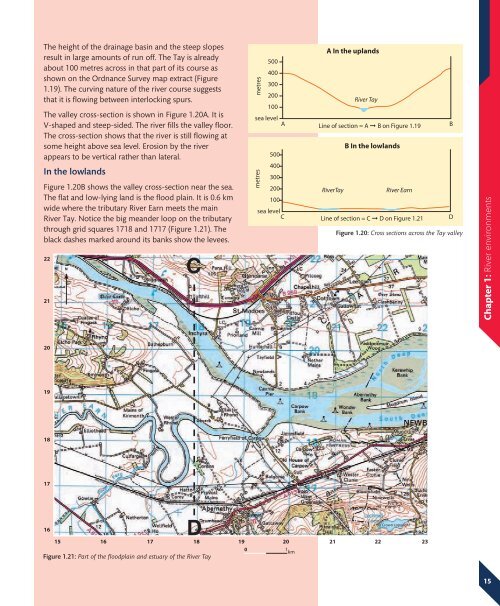
The height of the drainage basin and the steep slopesresult in large amounts of run off. The Tay is alreadyabout 100 metres across in that part of its course asshown on the Ordnance Survey map extract (Figure1.19). The curving nature of the river course suggeststhat it is flowing between interlocking spurs.The valley cross-section is shown in Figure 1.20A. It isV-shaped and steep-sided. The river fills the valley floor.The cross-section shows that the river is still flowing atsome height above sea level. Erosion by the riverappears to be vertical rather than lateral.In the lowlandsFigure 1.20B shows the valley cross-section near the sea.The flat and low-lying land is the flood plain. It is 0.6 kmwide where the tributary River Earn meets the mainRiver Tay. Notice the big meander loop on the tributarythrough grid squares 1718 and 1717 (Figure 1.21). Theblack dashes marked around its banks show the levees.2221NCmetresmetres500400300200100sea levelA500400300200100sea levelCA In the uplandsRiver TayLine of section = A ➞ B on Figure 1.19BB In the lowlandsRiver TayRiver EarnLine of section = C ➞ D on Figure 1.21 DFigure 1.20: Cross sections across the Tay valley<strong>Chapter</strong> 1: River environments2019181716D© Crown copyright151617 18 19 20 21 22 230 1 kmFigure 1.21: Part of the floodplain and estuary of the River Tay15