Edexcel IGCSE Geography Chapter 1 - Pearson Schools
Edexcel IGCSE Geography Chapter 1 - Pearson Schools
Edexcel IGCSE Geography Chapter 1 - Pearson Schools
You also want an ePaper? Increase the reach of your titles
YUMPU automatically turns print PDFs into web optimized ePapers that Google loves.
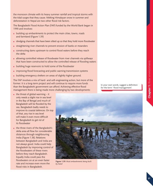
the monsoon climate with its heavy summer rainfall and tropical storms withthe tidal surges that they cause. Melting Himalayan snow in summer anddeforestation in Nepal are two other flood risk factors.The Bangladeshi Flood Action Plan (FAP) funded by the World Bank began in1990 and involves:●●●●building up embankments to protect the main cities, towns, roadsand farmland (Figure 1.39)dredging channels that have been silted up so that they hold more floodwaterstraightening river channels to prevent erosion of banks or meandersconstructing dams upstream to control flood waters before they reachthe delta●●●●allowing controlled release of floodwater from river channels via spillwaysthat have been constructed to allow the controlled release of flooding watersbuilding huge reservoirs to hold some of the floodwaterimproving flood forecasting and public warning transmission systemsbuilding emergency shelters on areas of slightly higher ground.The FAP involves a mix of hard- and soft-engineering action, but more of theformer. It is a long-term project and will continue to require more fundsthan the Bangladeshi government can afford. Achieving effective floodmanagement there is being made more challenging by two developments:●●the threat of global warming – itonly needs a slight rise in sea levelin the Bay of Bengal and much ofBangladesh will be flooded by thesea. Bangladesh badly needs toimprove its coastal defences. On topof that, any rise in sea levelwill make it even more difficultfor Bangladesh to get rid ofits floodwaterthe three rivers of the Bangladesh’sdelta area all flow for considerabledistances through neighbouringIndia (Figure 1.38). Relationsbetween Bangladesh and India arenot always good. India could helpBangladesh by improving control ofthe floodwaters of these riversbefore they reach Bangladesh.Equally India could pass thefloodwaters on at an even fasterrate and increase even more theflood risks in Bangladesh.Figure 1.39: Mud embankments being builtby handIn your own words, suggest a definitionfor the term ‘ flood management’.<strong>Chapter</strong> 1: River environments31


