BWood Appraisal.indd - Burnley Borough Council
BWood Appraisal.indd - Burnley Borough Council
BWood Appraisal.indd - Burnley Borough Council

Create successful ePaper yourself
Turn your PDF publications into a flip-book with our unique Google optimized e-Paper software.
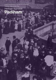
The Gospel HallThe Gospel Hall, Brunswick Street, also a locally listedbuilding (see 3.3.1.42), was built in 1897 and retains much ofits character although it is presently unused and therefore atrisk. It was originally built as a Liberal Club and used as suchat least until 1930. The original “Liberal Club” inscription canstill be seen above the main entrance.Several other Churches have been demolished but can beseen on plans C-E – Lincoln Street Chapel, Healey Woodarea, opened 1883; Hollingreave Congregational Church andSchool, 1887/95 redeveloped as an Anchor Housing site in1981.3.5.27 Many School buildings were associated withChurches where they developed from Sunday Schoolbuildings. The Education Act of 1870 aimed to provide freeand compulsory education for all children. Under this act the<strong>Burnley</strong> School Board was established in 1871. However thefirst Board School, Abel Street Board School, was not openuntil 1891. <strong>Burnley</strong> Wood Board School was the second tobe opened in 1892 and was designed by a London Architect,G. E. Laurence. Although much of the original building, which is within <strong>Burnley</strong> WoodConservation Area (see 3.3.1.29), remains it has been converted to houses and newhousing units built around it and the site is gated and screened by landscaping. Thebuilding retains most of its character but is somewhat concealed.Former <strong>Burnley</strong> Wood Board School3.5.28 The street pattern and high-density terraced housingdid not create opportunities for open spaces outside ofthe street network with the exception of the <strong>Burnley</strong> Woodschool grounds and St. Stephenʼs Church grounds.However,Bennett IV p 37 states that <strong>Burnley</strong> Wood Recreation groundnear towneley station had been provided by 1891 but closedin 1895 when Towneley Holmes was acquired. It is not clearwhether this was the pleasure gardens off Hufling Lane (see3.4.13) or the Recreation Ground which first appears on the1910 Ordnance Survey Plan and is still in use today.Although not within the NAP area, Towneley Park (See 3.4.14)entrance lies opposite Parliament Street on Todmorden Road.Allotments were also developed to the west of the railway line.To the north west of the area the canalside also provides alinear open space.3.5.29. The combination of the landfalls and the straight streetpattern created long, extensive views through and beyondthe area, over the town and surrounding hills to the north (seePlan F). Views to the east, west and south are less extensivebut significant, particularly in relation to the visibility of the landmarkbuilding at St. Stephenʼs Church (see Plan F) and trees outside character area 2which itself lacks soft landscaping features.Recreation groundView down Oxford RoadHollingreave Congregational Church c.1910 [L]View down Oxford Road [L]