

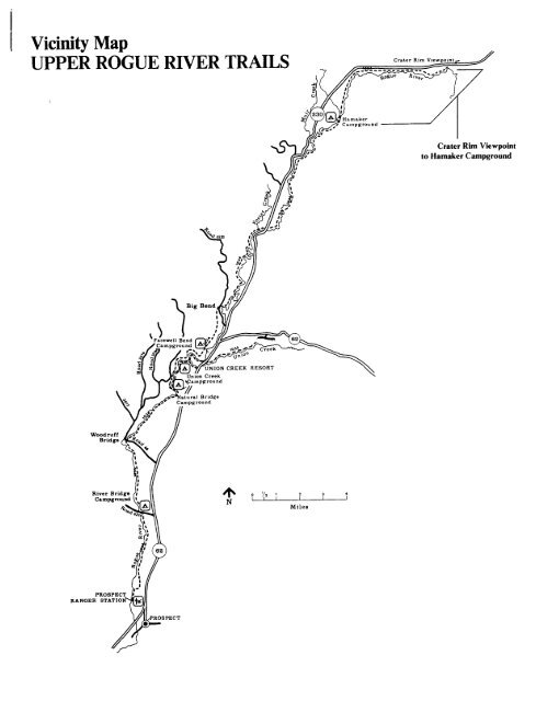
Vicinity Map UPPER ROGUE RIVER TRAILS
Vicinity Map UPPER ROGUE RIVER TRAILS
Vicinity Map UPPER ROGUE RIVER TRAILS

You also want an ePaper? Increase the reach of your titles
YUMPU automatically turns print PDFs into web optimized ePapers that Google loves.
<strong>Vicinity</strong> <strong>Map</strong><strong>UPPER</strong> <strong>ROGUE</strong> <strong>RIVER</strong> <strong>TRAILS</strong>C,.t., RimCrater Rim Viewpointto Hamaker Campground[ION CREEK RESORTWoodruffBridge,NLJ~-!2I3I IMilesRANGERiPECT
RECREATION OPPORTUNITY GUIDE<strong>UPPER</strong> <strong>ROGUE</strong> <strong>RIVER</strong> TRAIL #1034Hamaker Campground to Foster Creektcl"'ILength: 10 MilesDifficulty: Easy to moderate rolling gradesSeason: June through October 230 _Elevation: 5,200' u .4.A9- AM__ _ _ _ _ _ _ _ _ _ _ _iCAM;Ten miles of trail follow this meandering section of the upper Rogue Riveras it winds through marshy meadows and carves channels in buff-colored 7G,pumice.This section of the river trail begins on Forest road #900, across fromHamaker Campground. The trail heads away from the river through_a stand of white fir and western white pine. It joins the river HIGHWAY ;' @2 miles later near the confluence of Muir Creek and the Rogue. FALLS \ '4538'z-The trail continues south through grassy meadows with alder thickets ' -tand huckleberry bushes bordering the marshy river channel. Aftercrossing Hurryon Creek, the grade fluctuates as the trail crosses aCseries of pumice banks before reaching the riverbank again nearHighway Falls. The river pours over a short section of rapids, |then turns sharply south to parallel Highway 230.1INationalCreekBeyond Highway Falls, the trail climbs to the top of a pumice cliff andampoffers a dramatic view of the river, finding its way through a maze oflogjams far below. The trail descends with a series of switchbacks tof Lthe riverbank, following it closely through a secluded stand of mature vforest. After crossing National Creek on a footlog, the trail climbs to > . a.Forest road #6530, crosses the river on the road bridge embankment toTERcontinue south along the west bank. The last 0.5 mile of trail climbs OS TERalong the pumice roadcut overlooking the highway and drops through a CREEK TRA]series of switchbacks to the Foster Creek trailhead.Access:sFollow Highway #62 northeast until you reach the junction with 4o g 2Highway #230. Travel north on Highway #230 for approximately14 miles until you reach the #6530 road. Turn right and followthis road until you reach the #900 road. Trail begins east ofHamnker Camoirolindfi*<strong>ROGUE</strong> <strong>RIVER</strong> NATIONAL FORESTProspect Ranger District,Prospect, OR 97536 (541)560-3400
<strong>Vicinity</strong> <strong>Map</strong><strong>UPPER</strong> <strong>ROGUE</strong> <strong>RIVER</strong> <strong>TRAILS</strong>Crater Rim ViHamaker Campgroundto Foster CreekCREEK RESORT4%0 /, I 2 , 4Y., I INMiles
RECREATION OPPORTUNITY GUIDE*s 4<strong>UPPER</strong> <strong>ROGUE</strong> <strong>RIVER</strong> TRAIL, #1034 \ \ * /4Foster Creek to Big Bend Trailhead~~ ; ~~~1./'A ~ ~ EA~~~~~~~~~~~~~/z FOSTER - C 1 .i_ . e82l~~~~~~~t CREEK THAI HEADLength: 7 MilesDifficulty: Gentle to moderate rolling gradesSeason: June through October -,-J',3IFor 7 miles of easy walking, the trail explores a peaceful section 0'of the Rogue River Canyon, then continues south to join Hershberger N. /Rd. #6510. The scene is unique because it reveals the Rogue'scontinuing struggle to recover from the pumice avalanche thatburied its channel during the eruptions of Mt. Mazama. Eroded ( /pumice bluffs and exposed lava rock from earlier lava flows \ 7testify to the river's erosive abilities. Here, the Rogue follows \ 3743a meandering path through a maze of abandoned oxbows, peninsulas,and forested islands.Leaving from the Foster Creek trailhead on Highway 230, the trail 2 3fords Foster Creek and finds its way through a brushy riparian Abandone d - $thicket into a mature conifer forest. A varied array of small Trail Ai ,lplants carpets the forest floor. The most common species are Y llvanilla leaf, squaw carpet, Oregon grape, inside-out flower,pinemat manzanita, and wild strawberry. ~-About 1 mile downstream, the trail leaves the river for a short o l|time to climb a pumice cliff. The trail also passes through one Aof many marshy areas inhabited by skunk cabbage and a variety ofsmall water creatures.Besides the abundant wildlife of the area, cattle are frequently'seen grazing in the meadows along the riverbank. Several largelogjams slow the flow of the river and offer shelter for cutthroat \trout. Five miles downstream, on the south side of the footbridge,the trail passes the abandoned 0.5 mile trail west to the oldBrown's Cabin trailhead. Brown's Cabin was the site of an earlyday Forest Service ranger station. Continuing south, the trailclimbs and traverses a pumice bluff with views of the rapids below.The trail follows the river's edge as it winds around Big Bend andterminates on Forest road #6510, one mile from the junction with Hwy. 230.LUFF~~<strong>ROGUE</strong> <strong>RIVER</strong> NATIONAL FORESTProspect Ranger District,Prospect, OR 97536 (541)560-3400BIG BENDILHEADlR ENFY2
<strong>Vicinity</strong> <strong>Map</strong><strong>UPPER</strong> <strong>ROGUE</strong> <strong>RIVER</strong> <strong>TRAILS</strong>Crater Ri.Foster Creekto Big BendCREEK RESORTWoodruffBridgeNL W-~ LMiles2 3 4I I I
RECREATION OPPORTUNITY GUIDE<strong>UPPER</strong> <strong>ROGUE</strong> <strong>RIVER</strong> TRAIL, #1034Big Bend to Natural Bridge Viewpoint ° 1diJBIGBEND GTRAILHEADLength: 7 MilesDifficulty: Moderate rolling grades 3493-Season: June through OctoberConnecting Trails: Rogue Gorge Trail 230Elevation: 3300'FAREWELL BENDThe trail rises and falls with frequent switchbacksCAMPGROUND\following gullies in the terrain. Two miles south,a steep forested slope overlooks Farewell Bendvcampground across the river. At the southern end<strong>ROGUE</strong>of the campground area, the trail momentarily descends ROGEto river level to view the water raging through the \ elong, narrow chute of a collapsed lava tube. ,- -fi / N>Continuing south, the trail will wander away from -- CREEKL5the river. 0 ) A RESORTAccess:-- ,UNION CRThe trail begins from the Big Bend trailhead on Forestroad #6510, 1 mile west of Hwy. 230. The route startsat the road, climbs a rocky embankment, and traverses a I 62steep slope overlooking the Rogue River. A brief openingin the trees offers a glimpse of Fish Mountain to thenorth.'\ NATURAL BRIDGExCAMPGROUNDOne mile south of the Flat Creek crossing, the trail junctionsawith a tie-thru trail which leads to a footbridge crossing theRogue River. This bridge provides access to the Rogue GorgeTrail and the north end of the Natural Bridge campground.Continuing south on the Upper Rogue River Trail for the final . NATURAL BRII )GEmile of this segment leads to the Natural Bridge ViewpointVIEWPOINTand footbridge. This area is one-half mile west of Hwy. 62,accessible by Forest Road #300.0FAs<strong>ROGUE</strong> <strong>RIVER</strong> NATIONAL FORESTProspect Ranger District,Prospect, OR 97536 (541)560-3400
. <strong>Vicinity</strong> <strong>Map</strong><strong>UPPER</strong> <strong>ROGUE</strong> <strong>RIVER</strong> <strong>TRAILS</strong>Big Bend toNatural BridgeCampgroundDN CREEK RESORTWoodruffBridge4% N0 X'/ 1Miles2 3 II I I
RECREATION OPPORTUNITY GUIDEt<strong>UPPER</strong> <strong>ROGUE</strong> <strong>RIVER</strong> TRAIL, #1034Natural Bridge Viewpoint to Woodruff BridgeI10 -° NATURAL BRIDGES CAMPGROUNDLength: 3.5 milesDifficulty: Easy to level gradeSeason: June through October-, zK\Natural Bridge, a feature with geologic, historic and scenicinterest, marks the beginning of this 3.5 mile section of thetrail. The route follows the bank along a picturesque anddiverse section of the Rogue River.At Natural Bridge, the river is swallowed by an undergroundmaze of lava tubes. A fraction of the flow is released intoa small pool directly below the bridge. The remainder of thediverted water surges back to the surface and is visible fromthe viewpoint bridge. The largest of these angles out fromunder the east bank into the main channel, returning the riverto its full strength.The trail begins one-half mile west of Highway 62, near theNatural Bridge Viewpoint bridge. The route winds along thebank over a rough tread of mossy lava rock which becomes veryslippery in wet weather. Vegetation along the trail alternatesbetween sheltering old-growth forest and brush, while the river'scharacter varies between rapids and pools of quiet water. Thetrail climbs high above the river where it bends sharply and ragesthrough the narrow chute of a collapsed lava tube. This beautifulrapids is known as Knob Falls.As the trail approaches Woodruff Bridge, several old skid roadsare encountered. A developed picnic area is available atWoodruff Bridge. This is also a favorite fishing spot. Pleaseuse caution around the water - the river is dangerous due toextremely cold water and a strong, forceful current.WOODRUFBRIDGEv70 V 2ll.Miles<strong>ROGUE</strong> <strong>RIVER</strong> NATIONAL FORESTProspect Ranger District,Prospect, OR 97536 (541)560-3400
icinity <strong>Map</strong><strong>UPPER</strong> <strong>ROGUE</strong> <strong>RIVER</strong> <strong>TRAILS</strong>Big Bend.| [f9O REEK RESORTFa e I Union CreekWodrf ICA ampground'I _,< Natural BridgeBridge -I .pg - .dNatural Bridge Campgroundto Woodruff BridgeWoodruff /Bridge i . /4% N0 1/, 2 3 4MilesRANGER
RECREATION OPPORTUNITY GUIDE<strong>UPPER</strong> <strong>ROGUE</strong> <strong>RIVER</strong> TRAIL, #1034Woodruff Bridge to River Bridge CampgroundLength: 4.6 MilesDifficulty: Easy grade, moderate pitchesSeason: June through OctoberElevation: 2700'The wild raging character of the Rogue River passing throughTakelma Gorge is a key attraction on this section of theUpper Rogue River Trail.Beginning from the Woodruff Bridge Picnic Area on Forest Road#68, the trail heads downstream past a scarred, eroded pumiceslope on the opposite bank. Alder, vine maple, cow parsnip,and horsetail line the river until it reaches the dark-coloredlava cliffs of Takelma Gorge, 1.5 miles south. Here the riverdrops through a series of rapids and turns sharply to enterthe gorge itself. The narrow channel continues for 0.5 miles.This section of trail has a rocky tread with a few steeper grades.Below Takelma Gorge, the river widens and flows calmly pastthe Union Rogue Baptist Church Camp, while the trailreturns to pumice flats along the river. Raptors, suchas the shy goshawk, can be seen on this section of theriver. The trail ends at the River Bridge Campgroundon Forest Road #6210.ACCESS: From Prospect drive north on Hwy. 62 until youreach the Woodruff Bridge picnic area. You will seethe trailhead.N 0 /2 IMiles<strong>ROGUE</strong> <strong>RIVER</strong> NATIONAL FORESTProspect Ranger District,Prospect, OR 97536 (541)560-3400
<strong>Vicinity</strong> <strong>Map</strong><strong>UPPER</strong> <strong>ROGUE</strong> <strong>RIVER</strong> <strong>TRAILS</strong>Crater Rim Vi+ 1L WWMiles2 3 4I ICreekRESORTWoodruffBridgeRANGER
RECREATION OPPORTUNITY GUIDE<strong>UPPER</strong> <strong>ROGUE</strong> <strong>RIVER</strong> TRAIL, 1034River Bridge Campground to ProspectCAMPGROUR VDGENDLength: 6.5 MilesDifficulty: Easy rolling gradesSeason: June through OctoberThis section of the Upper Rogue River Trail parallels aquiet stretch of river and ends at a small diversionreservoir 1.0 mile south of the Forest Boundary. Thisreservoir joins with waters from the South Fork of theRogue and are diverted through two wooden penstocks(pipes) to a hydroelectric power plant.fat. d 1The trail begins at River Bridge Campground, located 1 milewest of Hwy. 62 on Forest Road #6210, and heads downriveralong the east bank. The trail crosses a brushy, sandybeach piled with driftwood and enters a stand of tall sugarpine, which has carpeted the forest floor with its needlesand cones. Occasional views of the river occur where thetrail nears the edge of 20-foot bluffs bordering the riverchannel.Private LandL, iv PICNIC AREAThe last 4 miles of trail leave the river and wind through 't-_(i PROSPECTa stand of younger trees. The backwaters of the reservoir \ RANGER STt.are visible as the trail returns to the riverbank. It thenjoins and follows an old road to the picnic area at the \/edge of the reservoir. A 0.5 mile access road connectsto Hwy. 62 from the dam, marking the end of the UpperRogue River Trail.PROSPECTNI0 l/2Milesrun<strong>ROGUE</strong> <strong>RIVER</strong> NATIONAL FORESTProspect Ranger District,Prbspect, OR 97536 (541)560-3400
<strong>Vicinity</strong> <strong>Map</strong><strong>UPPER</strong> <strong>ROGUE</strong> <strong>RIVER</strong> <strong>TRAILS</strong>[ION CREEK RESORTWoodruffBridge+ 1° 12oN2Miles3 iI IRiver Bridgeto ProspectRANGER


