JOHN HARRINGTON, JR. Curriculum Vitae January 2012 Personal ...
JOHN HARRINGTON, JR. Curriculum Vitae January 2012 Personal ...
JOHN HARRINGTON, JR. Curriculum Vitae January 2012 Personal ...

Create successful ePaper yourself
Turn your PDF publications into a flip-book with our unique Google optimized e-Paper software.
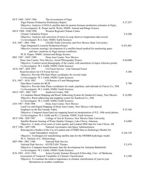
OCT 1988 - NOV 1988 The Government of NigerNiger Pasture Production Preliminary Report $ 27,297Objective: Analysis of NOAA satellite data for pasture biomass production estimates in Niger.Co-investigators: R. Pieper and B. Wylie, NMSU Animal and Range ScienceMAY 1988 - FEB 1990 Western Regional Climate CenterClimate Validation Project $ 9,200Objective: Analysis and correction of errors in coop observer temperature data record.Co-investigator: R.A. Earl, NMSU Earth SciencesJUL 1987 - DEC 1988 USAID (Tufts University and New Mexico State University)Niger Integrated Livestock Production Project $ 451,081Objective (remote sensing): development of a satellite-based method for monitoring spaceand time variations in Niger pasture conditions.PI: R. Pieper, NMSU Animal and Range ScienceDEC 1987 - NOV 1988 Dona Ana County, New MexicoDona Ana County, New Mexico, Aerial Photography Project $ 60,000Objective: Contract aerial photography of the county with annotation of major reference points.Co-Investigator: W.J. Gribb, NMSU Earth SciencesAUG 1987 - SEP 1987 US Forest Service - Gila National ForestRoad Inventory for US Forest Service $ 200Objective: Provide NM State Plane coordinates for several roads.Co-Investigator: W.J. Gribb, NMSU Earth SciencesJUL 1987 - AUG 1987 US Bureau of Land ManagementData Base Creation for BLM $ 700Objective: Provide State Plane coordinates for roads, pipelines, and railroads in Chaves Co., NM.Co-Investigator: W.J. Gribb, NMSU Earth SciencesMAY 1987 - DEC 1987 Sandoval County, NMA Computer-Based Mapping and Rural Addressing System for Sandoval County, New Mexico $ 14,908Objective: Rural addressing and mapping system for Sandoval Co., NMCo-Investigator: W.J. Gribb, NMSU Earth SciencesJAN 1987 - FEB 1988 Dona Ana County, New MexicoLand Use and Digital Mapping of Dona Ana County, New Mexico with SpecialEmphasis on the Rio Grande Valley $ 55,108Objective: Computer-based land use mapping based on interpretation of JUL 1986 aerial photos.Co-Investigators: W.J. Gribb and R.J. Czerniak, NMSU Earth SciencesOCT 1986 - SEP 1987 College of Arts & Sciences, New Mexico State UniversitySatellite Remote Sensing of Water Quality Changes, Lake Chicot, Arkansas $ 4,000Objective: A study of ten years of water quality and Landsat MSS data for Lake Chicot, AROCT 1986 - SEP 1988 National Aeronautics and Space AdministrationRetrospective Studies of the Use of Landsat and AVHRR Data in Hydrologic Models forLand-Atmosphere Analysis $ 226,120Objective: Techniques for transforming satellite data for the SWRRB hydrologic model.PI: C. Duchon, O.U. Meteorology.SEP 1986 - DEC 1986 National Park ServiceNational Park Service - ANTIETAM: Themes $ 2,478Objective: Computer-based thematic data file development for Antietam Battlefield.Co-Investigator: W.J. Gribb, NMSU Earth SciencesJUN 1982 - AUG 1982 Junior Faculty Summer Research Fellowship, Univ. of OklahomaAssessment of Temporal Variability in Climatic Classification $ 3,500Objective: To examine the relative importance in climatic classification of year-to-yearfluctuations in weather conditions.