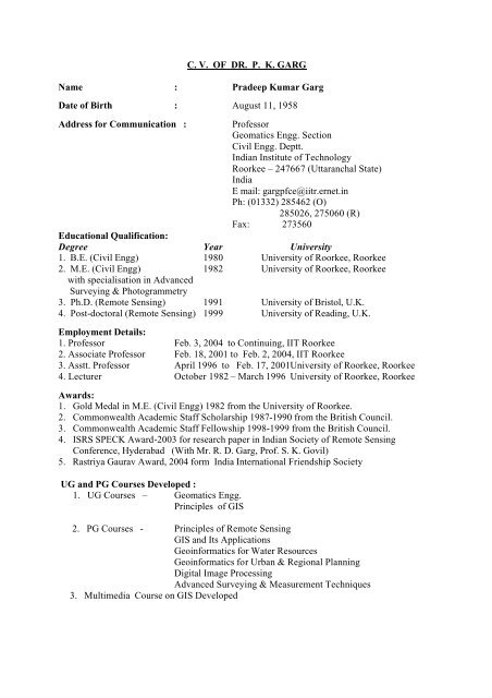
CV OF DR. PK GARG Name - Channel - Indian Institute of ...
CV OF DR. PK GARG Name - Channel - Indian Institute of ...
CV OF DR. PK GARG Name - Channel - Indian Institute of ...
Create successful ePaper yourself
Turn your PDF publications into a flip-book with our unique Google optimized e-Paper software.
12. Life Member <strong>of</strong> <strong>Indian</strong> Society for Continuing Education, Roorkee (LM-391)13. Life Member <strong>of</strong> <strong>Indian</strong> Society for Construction Materials & Structures (ISCMS), Roorkee (LM-623)14. Life Member <strong>of</strong> <strong>Indian</strong> Society <strong>of</strong> Geomatics, Ahmedabad (L-332)15. Life Member <strong>of</strong> <strong>Indian</strong> Society <strong>of</strong> Remote Sensing, Dehradun (L-0179)16. Life Member <strong>of</strong> <strong>Indian</strong> Society for Technical Education, New Delhi (LM-31814)17. Life Member <strong>of</strong> <strong>Indian</strong> Society for Rock Mechanics and Tunnelling Technology (LM-1619)18. Life member <strong>of</strong> <strong>Indian</strong> Society <strong>of</strong> Earthquake Technology (LM-1119)19. Life Member <strong>of</strong> <strong>Indian</strong> Society Agricultural Engineers (LM-10067)20. Member <strong>of</strong> IAHS, U.K. (2400)Member/Expert :1. Member in Bureau <strong>of</strong> <strong>Indian</strong> Standards (BIS), Optical Division, New Delhi2. Member in National <strong>Institute</strong> <strong>of</strong> Hydrology working group on Hydrological Observation andInstrumentation.3. Member PG Programme Formulation Committee IIRS Dehradun.4. Member Executive Committee Roorkee School for Deaf, Roorkee.5. Member Evaluation <strong>of</strong> Syllabus <strong>of</strong> Institution <strong>of</strong> Surveyors, Delhi (by AICTE Delhi).6. Member GIS Project Evaluation, AICTE, Delhi.7. Member Executive Council <strong>of</strong> <strong>Indian</strong> Water Resources Society (IWRS) Roorkee (2003-2005).8. Member Executive Council <strong>of</strong> <strong>Indian</strong> Society <strong>of</strong> Remote Sensing (ISRS) (2004-2006).9. Member Executive Council <strong>of</strong> <strong>Indian</strong> Association <strong>of</strong> Soil and Water Conservation,Dehradun (2004-2006).10. Member TIFAC CORE Centre for Disaster Mitigation, DST, New Delhi11. Member Project Formulation Committee on Digital Archaeology, University <strong>of</strong> Allahabad.12. Member Core Committee <strong>of</strong> Project Evaluation on Terrain Mapping, <strong>DR</strong>DO New Delhi.Visits Abroad:1. United Kingdom2. United States <strong>of</strong> America3. Germany4. Switzerland5. Spain6. Italy7. France8. ThailandResearch Areas:Land Surveying, Topographic Mapping, Remote Sensing, GIS, Cartography, Digitization &Image Processing, GPS, Natural Resources Inventory & MappingS<strong>of</strong>tware Used:Total Station S<strong>of</strong>tware, ARC/ INFO, SPANS, Geomedia, ER Mapper, ERDAS, MGE Intergraph,ARC VIEW, CAD, Statistical, Digitization, GPS etc.Remote Sensing Images Used:LANDSAT, SPOT, IRS, IKONOSOther Responsibilities:1. Coordinator, Centre for Remote Sensing, funded by All India Council for TechnicalEducation/Ministry <strong>of</strong> Human Resources Development.
2. Co-Coordinator, Science & Technology Entrepreneurship Park (STEP), IIT Roorkee3. O.C. Dairy, IIT Dairy
LIST <strong>OF</strong> PAPERS PUBLISHED (P.K. <strong>GARG</strong>)APPENDIX A(A) JOURNALS/BOOKS1. Monitoring Landuse and Landcover Changes using LANDSAT Imageries, Journal <strong>of</strong> the<strong>Indian</strong> Society <strong>of</strong> Remote Sensing, Vol. 12, No. 2, Dec. 1984 (with K.P. Sharma and S.C.Jain).2. Spectral Reflectance Pattern Study <strong>of</strong> Some <strong>Indian</strong> Landuse and Landcover Features,Journal <strong>of</strong> the <strong>Indian</strong> Society <strong>of</strong> Remote Sensing, Vol. 14, No.1, June 1986 (with K.P.Sharma and S. K. Verma).3. Hydrologic Soil Classification <strong>of</strong> a Part <strong>of</strong> Narmada Catchment using Remote Sensing Data,Journal <strong>of</strong> <strong>Indian</strong> Association <strong>of</strong> Hydrologist, Sept. 1987 (with K.P. Sharma and S.K.Chadha).4. Land Suitability Classification for Irrigated Cultivation using Remote Sensing Data, Journal<strong>of</strong> Institution <strong>of</strong> Engineers, Sept. 1987 (with K.P. Sharma and Anil Kumar).5. Remote Sensing for Highway Project Planning, Journal <strong>of</strong> the <strong>Indian</strong> Society <strong>of</strong> RemoteSensing, 1987/1988 (with K.P. Sharma and Ravi Kumar).6. Satellite Evaluations <strong>of</strong> Vegetational Change in Semi-Arid Mediterranean Landscapes,Chapter 6, In Remote Sensing for Hazard Monitoring and Disaster Assessment Marine andCoastal Applications in the Mediterranean Region (E.C. Barrett and K.A. Brown, Eds.),Gordon and Breach Science Publishers, London, U.K., 1991 (with A.R. Harrison).7. Land Degradation and Erosion Risk Analysis in S. E. Spain: A Geographic InformationSystem Approach. CATENA Int. Journal, Vol. 19, 1992 (with A.R. Harrison).8. Role <strong>of</strong> Expert Systems in Remote Sensing, Asian-Pacific Journal <strong>of</strong> Remote Sensing, Vol.5, No. 2, 1992 (with M. Arora).9. Role <strong>of</strong> Geographic Information System to Integrate Remote Sensing and Terrain Data,Journal <strong>of</strong> GIS India, Vol. 3, No. 1, pp. 11-17, 1994 (with Alak Roy).10. Geographic Information System as a Tool for Distributed Hydrologic Modelling, GIS India,Vol. No. 3, pp. 27-31, July 1994.11. Utility <strong>of</strong> IRS LISS II for the Extraction <strong>of</strong> LISS II for the Extraction <strong>of</strong> BasinCharacteristics, <strong>Indian</strong> Surveyor, July 1995 (with S.K.Ghosh and A.K. Nigam)12. GIS Based Landcover Study <strong>of</strong> Rural Area around Roorkee using ERDAS packages, GISIndia, Vol. No. 4, pp. 14-17, July 1995 (with K.P.Sharma and R.K.Shukla).13. Forest Fire Disaster Study using Remote Sensing Techniques, Himalayan Environment &Sustainable Development (Ed by P. B. Saxena), Surya International Publication, Dehradun,1995, pp 225-228.14. Remote Sensing as a Tool in Hydrology and Water Resources, Water Resources Planningand Management (Eds V. P. Singh & B. Kumar), Kluver Academic Publishers TheNetherlands, 1996, pp 261-277.15. Use <strong>of</strong> Digital Elevation Model in Run<strong>of</strong>f Modelling, Water Resources Planning andManagement (Eds V. P. Singh & B. Kumar), Kluver Academic Publishers The Netherlands,1996, pp 245-257.16. Use <strong>of</strong> Remote Sensing Technology for Soil Degradation Study, <strong>Indian</strong> Journal <strong>of</strong> WaterResources, Roorkee, 1997.17. Understanding Geographic Information Systems, Journal <strong>of</strong> GIS India, 1997.18. An Odyssey <strong>of</strong> <strong>Indian</strong> Space Programme, Asian Pacific Journal <strong>of</strong> Remote Sensing & GIS,Bangkok, 1997(with Nirupama).19. Utility <strong>of</strong> Remote Sensing in Archaeology, Chapter contributed in Book “Remote Sensing inArchaeology” by Alok Tripathi, Published by Sundeep Prakashan, Delhi (with Nirupama),1999.
20. Role <strong>of</strong> Geographic Information System in Archaeology, Chapter contributed in Book “RookSensing in Archaeology” by Alok Tripathi, Published by Sundeep Prakashan, Delhi (withNirupama), 1999.21. Global Positioning System - Future Scenario, GIS India, Vol 8, Issue 4, pp. 9-12,November-December 1999.22. Real – Time Surveying : Achievements & Developments, Journal <strong>of</strong> <strong>Indian</strong> Surveyors, 2000.23. Learn Remote Sensing, GIS and GPS Technologies Free on Internet, GIS India, Vol. 9, IssueNo. 6, pp. 15-17, Nov.-Dec., 2000.24. Use <strong>of</strong> Statistical Techniques for Inter-Block Disparities Analysis under GIS Environment,Journal <strong>of</strong> GIS India, Vol. 9, Issue 6, pp. 23, Nov.-Dec. 2000, (with R.D. Gupta, and M.Arora).25. A Modified Exterior Orientation Approach for IRS-1C Stereo Images, (with R.S. Tiwari,S.K. Govil, and Sonia Sarkis), Journal <strong>of</strong> <strong>Indian</strong> Surveyors, 2001.26. The Changing Paradigm <strong>of</strong> Governance, GIS@development, Vol. 5, Issue 5, pp. 21-22, May2001.27. Some E-Governance Initiatives in India GIS@development, Vol. 5, Issue 5, pp. 23, May2001.28. Remote Sensing & GIS Education and Training at the University <strong>of</strong> Roorkee, GIS India,Volume 10, No. 3, pp. 14-15, May-June 2001.29. Morphodynamic Modelling <strong>of</strong> Intertidal Sediment Transport in Morecambe Bay, Journal <strong>of</strong>Estuarine, Coastal and Shelf Science, 2001, 53, pp 79-92 (with D.C. Mason).30. Mapping Water Logged Area, GIS@development, pp. 43-45, Aug. 2001, (with M. SaiSudarsanam and Ranvir Singh).31. Water Logged Area Analysis with ARC/INFO, Arc Users Journal, Vol. 4, No. 2, pp. 20-21,USA Oct-Dec, 2001 (with M.Sai Sudarsanam and Ranvir Singh).32. Geographic Information System for Planner and Decision makers, Journal <strong>of</strong> <strong>Indian</strong> Societyfor Continuing Engineering Education, <strong>Indian</strong> <strong>Institute</strong> <strong>of</strong> Technology, Roorkee, pp. 29-34,January 2002.33. Waste Disposal Site Selection in GIS Environment, (with Jaideep Banerjee, Renu Bhargava,D. C. Singhal), GIS India, January 2002, Vol. 11 No. 1 pp. 12-15.34. Integrated Remote Sensing and GIS Approach to Study Water Logged Area, GIS India, Vol.11 No. 6, June 2002, (with M. Sai Sudarsanam & Ranvir Singh).35. GIS for Site Suitability in Urban Planning (with Vipin Soni, S. K. Ghosh, and S. K. Govil)Geospatial Today, May-June, 2003 Vol. 2 Issue 1 pp. 37-38.36. ARC/INFO helps Ground Water Mapping, submitted to Arc Users Journal (with A. PullaReddy).37. Remote Sensing & GIS for urbanisation and Run<strong>of</strong>f Study submitted to Hydrology Journal,(with O. P. Dubey and K. V. S. A. V. Prasad).38. Urban Land Use and Land Cover Change Analysis Through Remote Sensing & GIS, to bepublished in <strong>Indian</strong> Surveyor Journal, July 2003 (with O. P. Dubey and K. V. S. A. V.Prasad).39. Development <strong>of</strong> a S<strong>of</strong>tware for Engineering Surveys published in <strong>Indian</strong> Surveyor Journal,Jan-June, 2004 Vol. 58 No. 1 pp. 38-41. (with Piyush Hari and Praveen Singh).40. Innovation for Self reliance in Survey Instruments, SCI-TECH R &D Magazine <strong>of</strong> IITRoorkee, Vol 2 No. 2, 2003 pp 4-5.41. Remote Sensing Based Estimation <strong>of</strong> Cotton Canopy Cover Using Linear Mixture ModellingApproach submitted to Geocarto International Journal, (with N. Rama Rao and S. K. Ghosh)42. GIS Based Study for Automated Route Alignment submitted to <strong>Indian</strong> Society <strong>of</strong> RemoteSensing Journal, (With K. Ravi Shankar, P. K. Garg and M. Parida)
(B) CONFERENCES1. Manual v/s Digital Landuse Classification from Remotely Sensed Data – A Case Study inRoorkee-Dehradun Region <strong>of</strong> Northern India, Asian Conf. <strong>of</strong> Remote Sensing, Kathmandu,Nepal, Nov. 15-21, 1984 (with K.P. Sharma and S.C. Jain).2. Digital Classification <strong>of</strong> Landuse and Landcover Maps from LANDSAT Data, Int. Conf. onComputer Applications in Civil Engg., University <strong>of</strong> Roorkee, Roorkee, Jan. 29-Feb. 2, 1985(with K.P. Sharma, S.C. Jain and S.S. Negi).3. Visual Interpretation <strong>of</strong> LANDSAT Imagery for Monitoring Landuse Pattern, Seminar onRemote Sensing for Agriculture, Space Application Centre, Ahmedabad, Feb. 27-28, 1985(with K.P. Sharma, S.C. Jain and S.S. Negi).4. Computerized Landuse Surveys Through Remote Sensing, Workshop on New Trends inCivil Engg, Thaper College <strong>of</strong> Engg., Patiala, March 1-2, 1985 (with K.P. Sharma).5. Soil Erosion Studies in Garhwal Himalayas Using Remotely Sensed Data, Int. Conf. onIntegration <strong>of</strong> Remotely Sensed Data in GIS for Processing <strong>of</strong> Global Resource Information,Washington, D.C., USA, June 27-30, 1985 (with K.P. Sharma, D.C. Singhal and D.N.Kalita).6. Remote Sensing for Forests and Vegetation Mapping in Upper Yamuna Catchment, FifthConf. <strong>of</strong> <strong>Indian</strong> National Cartographic Association, University <strong>of</strong> Kashmir, Srinagar,Kashmir, Sept. 4-7, 1985 (with K.P. Sharma).7. Assessment <strong>of</strong> Landuse Changes in the Environment <strong>of</strong> Roorkee and its Surroundings,Second World Congress on Engineering and Environment, New Delhi, Nov. 7-9, 1985 (withK.P. Sharma).8. Flood-Plains Mapping in a Part <strong>of</strong> Ganges Basin Using Satellite Imagery, National Seminaron Remote Sensing <strong>of</strong> Water Resources, Space Application Centre, Ahmedabad, Dec 27-29,1985 (with K.P. Sharma and S.C. Jain).9. Monitoring Water Pollution Through Remote Sensing, National Seminar on Remote Sensing<strong>of</strong> Water Resources, Space Application Centre, Ahmedabad, Dec 27-29, 1985 (with K. P.Sharma).10. Role <strong>of</strong> Remote Sensing for Mapping and Monitoring Landuse Pattern, Int. Seminar onPhotogrammetry and Remote for the Developing Countries, New Delhi, Feb 15-17, 1986(with K. P. Sharma).11. Satellite Remote Sensing for Mapping <strong>of</strong> Flood-Plains and Allied Features, Int. Symp. onFlood Frequency and Risk Analysis, Louisiana, USA, May 14-17, 1986 (with K.P. Sharma,S.C. Jain and A.K. Dubey).12. Remote Sensing for Marine and Oil Pollution Seminar on Marine Disposal <strong>of</strong> Waste Water,Rio-de-Janeiro, Brazil, Aug 25-27, 1986 (with K.P. Sharma).13. Digital Landuse Classification in Himalayan Region from Remotely Sensed Data, Int. Conf.AUTO CARTO 1986, Imperial College, London, U.K., Sept 14-19, 1986 (with K.P.Sharma).14. Route Location Studies using Remote Sensing Techniques, Int. Conf. on TransportationSystem Studies, <strong>Indian</strong> <strong>Institute</strong> <strong>of</strong> Technology, New Delhi, Dec. 18-22, 1986 (with K.P.Sharma).15. Role <strong>of</strong> Remote Sensing for Wasteland Mapping and Analysis, In NRSA Seminar,Hyderabad, Nov 1987 (with K.P. Sharma, L.M. Pandey and A. Kankane).16. Wasteland Reclamation Studies through Remote Sensing, Int. Rangeland Congress, NewDelhi, Nov 1988 (with S.C. Jain).17. Quantitative Representation <strong>of</strong> Land-Surface Methodology from Digital Elevation Models,Int. Conf. on Spatial Data Handling, Zurich, Switzerland, July 23-27, 1990 (with A.R.Harrison).
18. Assessing Changes in Semi-Arid Land Surface through SPOT Albedo Images, RemoteSensing Society Annual Conf., Swansea, U.K., Sept. 1990 (with A.R. Harrison).19. The Use <strong>of</strong> Geographic Information System for Hydrologic and Erosion Modelling, AURISA90 Conf., From Innovation to Integration – Bringing it all together in the National Interests,Canberra, Australia, Nov 21-23, 1990 (with A.R. Harrison).20. Comparison <strong>of</strong> SPOT and Airborne Spectral Measurements <strong>of</strong> Semi-Arid Vegetation.Proceedings <strong>of</strong> NERC Symposium on Airborne Remote Sensing, Keyworth, Nottingham,U.K., Dec 18-19, 1990 (with A.R. Harrison).21. Assessment Sedimentation in Reservoir using Remote Sensing Techniques, SubmittedSpecial Meeting on Water Resources, Irrigation & Power Board, May, 1993 (with R. S.Tiwari).22. Soil Mapping and Classification from Remotely Sensed Data, Seminar on Remote Sensingfor Agriculture, Space Application Centre, Ahmedabad, Feb. 27-28, 1995 (with H.S. Iyer andS.K. Chadha).23. Landform and Landuse <strong>of</strong> Doon Valley and Their Role in Resource Management, Seminaron Sustainable Development in Doon Valley-Constraints <strong>of</strong> Geo-environment, Wadia<strong>Institute</strong> <strong>of</strong> Himalayan Geology, Dehradun, June 1995 (with R.S. Tiwari).24. Run<strong>of</strong>f and Soil Erosion in a Semi-arid Region, 7 th Nat. Symp. on Hydrology <strong>of</strong> Semi-aridRegions, Jaipur, Oct 1995.25. Quantity Surveying in Civil Engineering Curriculum, Nat. Seminar on Technical Education,New Delhi, Nov. 1995 (with R.S. Tiwari).26. Water Resources Development, Management and Monitoring using Remote SensingTechniques, 3 rd Int. Conf. on Environmental Planning & Management, Nagpur, Feb 1996.27. GIS-based Land Suitability Classification for Sustainable Development, Int. Conf on CivilEngg. for Sustainable Development, Department <strong>of</strong> Civil Engg., University <strong>of</strong> Roorkee,Roorkee, Feb 1997 (with R.S.Tiwari).28. Planning for School Education with Geographic Information System, Int. Conf on Planningfor 21 st Century, Department <strong>of</strong> Arch & Plng., University <strong>of</strong> Roorkee, Roorkee, Oct. 2-4,1998 (With S. K. Mishra).29. Coastal Area Sediment Transport Modelling – A Case Study from the Morecambe Bay,International Conference on Hydrology Days-1999, Colorado State University, Fort Collins,United States <strong>of</strong> America, Aug 15-18, 1999 (with D. C. Mason).30. Analysis <strong>of</strong> Intra-District Disparities for Dehradun District using GIS Technique, Map India2000, 3 rd Annual International Conference & Exhibition on GIS/GPS/RS, New Delhi, April10-11, 2000 ( with R. D. Gupta and Manoj Arora).31. Geographic Information System: A Versatile Tool for Planners, Seminar on Approach toPlanning in 2000 and Beyond, Department <strong>of</strong> Arch & Planning, University <strong>of</strong> Roorkee,Roorkee, April 28-29, 2000.32. Environmental Impact Assessment <strong>of</strong> Water Resources Projects using Remote Sensing,Seminar on Environmental and Social Issues in Water Resources Development, TheInstitution <strong>of</strong> Engineers (India), Lucknow, June 5- 6, 2000.33. Earth Observation Education and Training at the University <strong>of</strong> Roorkee, Roorkee (India),International Workshop on EO Education and Training and CEOS WG-EDU Meeting, <strong>Indian</strong><strong>Institute</strong> <strong>of</strong> Remote Sensing, Dehradun, Aug 9-10, 2000.34. Appropriate Technologies for Surveying and Mapping the Features Related to DrinkingWater, International Conference on Innovative Technologies for Rural Water Supply andEnvironmental Sanitation, Centre for Continuing Education, University <strong>of</strong> Roorkee, Roorkee(India), Oct 12-13, 2000.
50. Application <strong>of</strong> Remote Sensing and GIS in Water Resources Management and Development,National Symposia on Water Resources Management and Development with reference toGanga Basin UP, April 4-5, 2003, Lucknow.51. Optimum Route Alignment in Hilly Area by Implementation <strong>of</strong> Dijkstra’s Algorithm UsingGIS Techniques, Conference in Hyderabad, Sept. 2003 (with R. D. Garg and S. K. Govil).52. Transport Route Planning using Advanced Mathematical Algorithms in RS-GISEnvironment, ISPRS TC VIII/3, International Workshop on Integrated Monitoring Systems,Thiruanatnapuram, Dec. 9-12, 2003 (with R. D. Garg and S. K. Govil).53. Application <strong>of</strong> Remote Sensing and GIS in Water Resources, Forestry and Agriculture,Invited Lecture in National Workshop on Recent Trends in Earth Resources Mappingorganized by Civil Engg. Deptt, MANIT, Bhopal, June 29-30, 200454. Studying Water Logging in the Irrigation Command Area using Remote Sensing and GIS,International Seminar on Geoinformatics 2004 (Earth Science and Natural ResourceManagement), Dec. 13-14, 2004, Mysore. (With Naveen Shukla and D. Roy)55. Estimation <strong>of</strong> Leaf Area Index <strong>of</strong> Agricultral Crops using Remote Sensing Data,International Seminar on Geoinformatics 2004 (Earth Science and Natural ResourceManagement), Dec. 13-14, 2004, Mysore. (with N. Rama Rao and S. K. Ghosh)56. Determination <strong>of</strong> Local Gravimetric Geoid from Dense Gravity Anomaly Data : A caseStudy <strong>of</strong> Delhi Area, Map India 2005, Feb. 7-9, 2005, Delhi (with S. K. Singh and B.Nagarajan)
APPENDIX BSPONSORED PROJECTSCOMPLETEDS.No. <strong>Name</strong> <strong>of</strong> the project SponsoringAgencyAmountRs. (lacs)Year <strong>of</strong>Award1 Integration <strong>of</strong> GIS with Remote Sensing AICTE 10.0 1994 -1996Data for Natural Resources andEngineering Applications2 Landform Analysis in GIS <strong>DR</strong>IL, UOR 0.10 19943 Earthquake Impact Study using RemoteSensing TechniquesAICTE 10.0 1994 -19954 Rainfall-Run<strong>of</strong>f Modelling using DigitalElevation Model and Remote SensingData in GIS Environment5 Development <strong>of</strong> Utility Maps in GIS forUOR Campus6 Remote Sensing and GIS : TechnologyForecasting7 Environmental Impact Assessment <strong>of</strong>River Valley Projects using RemoteSensing & GIS Technique8 Development <strong>of</strong> Geoinformatics forSustainable Development9 Integrating Remote Sensing & GISTechnology for Land Suitability andErosion hazard Assessment10 Remote & GIS Application for GroundWater Management11 State-<strong>of</strong>-art in Optical SurveyingEquipmentIN PROGRESSMin. <strong>of</strong> WR 5.60 1994-1995<strong>DR</strong>IL, UOR 0.10 1996AICTE 3.00 1997UGC 5.00 1997AICTE 12.00 1997AICTE 5.00 1998UGC 0.50 2001DST 1.655 2002S.No. <strong>Name</strong> <strong>of</strong> the project SponsoringAgency1 Data Fusion for Improving ImageQuality and Classification2 Development <strong>of</strong> a Query based GISapproach for Rural IndustrializationAmountRs. (lacs)Year <strong>of</strong>AwardISRO 5.00 2003KVIC Mumbai 57.00 2003
COMPLETEDS. <strong>Name</strong> <strong>of</strong> the projectNo.CONSULTANCY PROJECTS1 Application <strong>of</strong> Remote Sensing Techniques forLanduse Classification and Delineation <strong>of</strong>Salinity Patches in Narmada Sagar Command2 Study <strong>of</strong> Environment in U.P. State using RemoteSensing Techniques3 Application <strong>of</strong> Remote Sensing Techniques forLanduse Classification and Hydrological Studiesin Subarnarekha Catchment4 Carrying Capacity based Developmental Planningin Doon Valley using RemoteSensing & GIS Techniques5 Identification <strong>of</strong> Suitable Sites for Small Hydrousing Remote Sensing and GIS6 Survey Investigation work for Small Hydro sitesin H.P. State7 Survey Investigation work for Small Hydro sitesin Gangotri, U.P. State8 Development <strong>of</strong> a GIS Based Technique forWatershed Prioritisation and Management9 Rail Route Alignment using Remote Sensing &GIS Techniques10 Topographical Survey <strong>of</strong> Rapti River CommandAreaSponsoringAgencyConsultingEngg ServicesKirloskarIndia Ltd.ConsultingEngg ServicesAmountRs. (lacs)Year <strong>of</strong>Award1.0 19830.50 19831.0 1985MEF 8.1 1993-1995UNDP 5.0 1995-1996HIMURJA 0.90 1996NEDA 0.85 1996Min. <strong>of</strong> RuralAreasMin.Railway<strong>of</strong>9.1 19979.1 1997PWD, U.P. 6.0 200111 Training on Modern Surveying Equipment IRCON, Delhi 2.10 200112 Training on Total Station & its Applications IRCON, Delhi 1.20 200113 Training on Surveying Measurement Techniques NCCBM,Delhi14 Alignment Survey <strong>of</strong> Bypass Road Near NainitalLakeUttaranchalGovt.1.30 20011.50 200215 Training on Modern Surveying Equipment IRCON, Delhi 1.40 200216 Training on Total Station & its Applications IRCON, Delhi 1.70 200217 Topographical Survey for Bridge Site onGhaghara River in Sant Kabir Nagar18 GPS Survey for DEM Generation <strong>of</strong> PatalgangaCatchmentU.P. Bridge 5.50 2003Corp.CRRI 0.80 2003
19 Feasibility Study <strong>of</strong> Taj Expressway J.P. I. L. 1.20 200320 Hydrological and Topographical Survey <strong>of</strong> TajExpressway (0 -7Km)J.P.I.L. 2.05 2003IN PROGRESSS.No.<strong>Name</strong> <strong>of</strong> the Project1. Topographical Survey <strong>of</strong> Maneri BhaliReservoir2 Preparation <strong>of</strong> DPR for RainwaterHarvesting work for Dehradun and AlmoraRegion3. Road Pr<strong>of</strong>iling Survey <strong>of</strong> NH-56, 57, 57Ain the NCR Region4. Advice on Hydrological & TopographicalSurvey <strong>of</strong> Taj Expressway5. Development <strong>of</strong> a GIS Based DSS forUrban Amenities in Rural Area6. Contouring and Mapping <strong>of</strong> Landslide NearPhata7 Creation <strong>of</strong> GIS Digital Data Base <strong>of</strong> DelhiRegionSponsoring Agency AmountRs. (lacs)Irrigation Deptt.,Uttaranchal Govt.Uttaranchal JalNigamYear <strong>of</strong>Award3.00 200315.00 2003CPWD 2.60 2003J.P.I.L. 2.42 2003DST 13.70 2003CBRI 2.50 2004CBRI 3.00 2004
APPENDIX CPh.D THESIS(A) AWARDED1. Rainfall-run<strong>of</strong>f Modelling using Digital Elevation Model and Remote Sensing Data(A. K. Nigam, 1999), (with S. K. Ghosh).2. Generation <strong>of</strong> Digital Elevation Data from Space Imageries (Sonia Sarkis, 2001), (R. S.Tiwari).3. Remote Sensing and GIS Based Decision Support System for District Level Planning(Rajan Dev Gupta, 2002) (with Manoj Arora).4. Development <strong>of</strong> a Method for Digital Rectification <strong>of</strong> Images (Kamal Jain, 2003)5. GIS Based Decision Support System for Rural Road Network Planning (R. D. Garg).(C) IN PROGRESS1. Drought Mapping and Management using Remote Sensing & GIS Techniques (P.H. ShivaPrakash).2. Irrigation Command Area Management using Remote Sensing & GIS Techniques (NaveenK. Shukla)3. Land Surface Characterization And Retrieval <strong>of</strong> Vegetation Parameters From RemoteSensing Techniques (N. Rama Rao).6. Determination <strong>of</strong> High Resolution <strong>of</strong> <strong>Indian</strong> Geoid for GPS Levelling (S. K. Singh).7. Rule Based Route Alignment in Hilly Terrain Using GIS (K. Venkatreshwarlu).8. Remote Sensing & GIS based Modelling for Conjunctive Use <strong>of</strong> Water (Mahesh Kumar Jat)
APPENDIX DM.E. THESIS SUPERVISED(A) COMPLETED1. Evaluation <strong>of</strong> Environment Changes in Roorkee and its Surroundings using Remote SensingTechniques (S. K. Verma, Feb., 1983) (with K. P. Sharma).2. Soil Mapping and Hydrologic Soil Classification in a Part <strong>of</strong> Narmada Catchment usingRemotely Sensed Data (S. K. Chadha, Oct., 1984) (with K. P. Sharma).3. Soil Erosion Studies in Tehri Garhwal Region using Remotely Sensed Data (D.N. Kalita,Nov., 1984) (with K. P.Sharma and H.S. Iyer).4. Terrain Evaluation <strong>of</strong> Doon Valley and its Adjoining Area using Remote SensingTechniques (K.K.Pande, Feb., 1985) (with K.P.Sharma).5. Monitoring Agricultural Crops in Saharanpur District using Satellite Imagery (Anil Kumar,June, 1986) (with K.P.Sharma).6. Terrain Evaluation for Road Alignment Studies from Remotely Sensed Data (Ravi Kumar,July, 1986) (with K.P.Sharma).7. Analysis <strong>of</strong> Remotely Sensed Data for Wasteland Mapping in Northern India (AtulKankakee, 1987) (with S.C. Jain and L.M. Pande).8. Detection <strong>of</strong> Linear Features using Various Filters on Satellite Images (Vijay Veer, 1992)(with S.K.Ghosh).9. Generation <strong>of</strong> GIS Database for Rural Area around Roorkee (R.K. Shukla, 1992) (withK.P.Sharma).10. A Study on Various Change Detection Techniques using Digital Remote Sensing Data (G.T.Rao, 1993) (with S.K. Ghosh).11. A Feasibility Study on the Selection <strong>of</strong> Training Data for Image Analysis (Ajay Mathur,(1993) (with S.K. Ghosh).12. A study <strong>of</strong> Various Feature Selection Techniques in Digital Remote Sensing Analysis (D.K.Jha, 1993) (with S.K. Ghosh).13. A Study on Landuse and Agricultural Practices for Rural Areas around Roorkee usingRemote Sensing Techniques (Ajay Kumar, 1994) (with K.P.Sharma).14. Development <strong>of</strong> a Methodology for Photogrammetric Monitoring <strong>of</strong> the Settlements andDeformation <strong>of</strong> Structures (Sonia Sarkis, 1995) (with R.S. Tiwari).15. Classification <strong>of</strong> Forest Types <strong>of</strong> Dehradun Region from Multi temporal Satellite Data (HariNath Misra, 1995) (with R.S. Tiwari).16. Selection <strong>of</strong> Suitable Sites for Small Hydro Power Schemes using Remote SensingTechniques (V. Madhav Rao, 1996) (with R.S. Tiwari)17. Assessment <strong>of</strong> Soil Degradation Hazards through Remote Sensing (R. Ganesh Prasad, 1996)18. Assessment <strong>of</strong> Changes in Landcover Features due to Earthquake using Remote SensingTechniques (G. Sreenivas Reddy, 1996) (with R.S. Tiwari).19. Distributed Erosion Modelling using Remote Sensing Technique (M.S. Ganesh Prasad, 1997)20. Forest Mapping using IRS-IC Data (M. Sri Kumar, 1997) (with P.S. Roy)21. Integration <strong>of</strong> Remote Sensing Data with Ancillary data for Watershed Prioritization(Seemant, 1997) (with R.S. Tiwari).22. Use <strong>of</strong> GIS in District Level Planning for School Education (SK Mishra, 1997).23. Application <strong>of</strong> GIS for Hydrologic Soil Classification (Ragini Sinha, 1998).24. Digital Terrain Modeling in GIS (B. Pawan Kumar, 1998).25. Development <strong>of</strong> a Decision Support System in GIS to Combat Forest Fire (M.Sreedhar,1998) (with P.S. Roy).26. Planning for Infrastructure using GIS (Kavita Maddula) (with A.M.A. Siddiqui).
27. Development <strong>of</strong> Expert System for Wasteland Development (Udai Kiran, 1998) (withSrinivas Panday).28. A GIS Study to Assess the Impact <strong>of</strong> Urbanisation & its Impact on Run<strong>of</strong>f ( K. V. S. A.Prasad, 2000) (with O.P.Dubey).29. Site Selection for Waste Disposal in GIS (Jaideep Banerjee, 2001) (with Renu Bhargava andD.C. Singhal).30. Water Logged Area Mapping and Analysis using Remote Sensing & GIS Technique (M. S.Sudarsanam, 2001) (with Ranvir Singh).31. Hardwar Tourist Information System (Anurag Ohri 2002) (with Dr. S. K. Ghosh)32. Information System for Map Referencing (Venkata A. Rao Chintala 2002)33. Groundwater Mapping & Management in GIS Environment (A. Pulla Reddy)34. Selection <strong>of</strong> Water Supply Sources using GIS (Shailza Verma, 2002) (with Renu Bhargava)35. Digital Uttaranchal for e-Governance (P. Ventkata Reddy, 2002)36. GIS-Based Soil Erosion Study for Watershed Management (Rakesh Kumar, 2002) (withAjay Gairola)37. GIS Based Study for Rain Water Harvesting – A Case Study for Mussoorie (Regalado H.Carandang, 2002) (with Deepak Khare)38. Study <strong>of</strong> River <strong>Channel</strong> Modifications using Numerical Techniques (Patitapaban Das) (withNayan Sharma)39. Development <strong>of</strong> a Multimedia for GIS (Shiv Kumar, 2003).40. Tourism GIS for Uttaranchal State (K. Venkateswarlu, 2003) (with S. K. Ghosh).41. GIS Based Feasibility Study for Airship Travel in a Part <strong>of</strong> Uttaranchal State (D. RaviKumar, 2003) (with S. K. Ghosh).42. GIS for Site Suitability in Urban Planning (Vipin Soni, 2003) (with S. K. Ghosh).43. GIS Based Seismic Microzonation <strong>of</strong> Western Part <strong>of</strong> Ahmedabad City (Samit Shrivastava,2003) (with V. H. Joshi)44. Study on Morphological behaviour <strong>of</strong> River Kosi using Remote Sensing & GIS (Mr.Ashish Namdeo, 2003)45. Assessment <strong>of</strong> reservoir sedimentation using Remote Sensing (Mr. Reetesh Katiyar, 2003)46. GIS based Feasibility Study on Taj Expressway (Mr. K. Ravi Shankar, 2003)47. GIS based Modelling for Rural Infrastructural Planning (Mr. Polamreddi Shrinu, 2003)ON GOING1. Seismic micro-zonation study <strong>of</strong> urban area in GIS environment (A. V. Subramanyam)2. River Interlinking using Geospatial data (Anurag Lahare)
APPENDIX FBOOKS/MONOGRAM(A) PUBLISHED1. Water Resources Investigations using Remote Sensing Techniques (AICTE Monogram,1998) (with Nirupama).2. Remote Sensing for Natural Resources Inventory & Management, published by M/s WheelerPublishing Co, Delhi (2000) (with C. S. Agarwal).3. Geographic Information System and Its Utility (AICTE Monogram, 2002).4. Fluid Mechanics and Fluid Power (Eds with P. C. Jain, J. S. Saini, and Ajay Gairola)published by Ajay Printers and Publisher Roorkee, 2002.(B) UNDER PUBLICATION1. Groundwater Evaluation: Principles and Applications (To be published by Narosa,Publishing House, New Delhi) (with C. S. Agarwal).EDUCATIONAL VIDEO FILMAPPENDIX G1. Film on Story <strong>of</strong> Mapping, Part I and Part II, completed for the University GrantsCommission (UGC), Govt. <strong>of</strong> India, New Delhi, under their Educational Programme, 2001.2. Film on GPS & its Applications, for UGC Educational Programme is under consideration.APPENDIX HORGANISATION <strong>OF</strong> NATIONAL / INTERNATIONAL CONFERENCE1. Joint Organising Secretary <strong>of</strong> CETETH National Conference on Cost Effective TechnicalEducation and Training <strong>of</strong> the Handicapped, February 22-24, 1997.2. Organising Secretary <strong>of</strong> 2 nd International and 29 th National Conference on Fluid Mechanicsand Fluid Power, Dec. 12-14, 2002.3. Organising Secretary <strong>of</strong> Surveying Equipment Conclave and Exhibition for VendorDevelopment, June 29, 2003.4. Organised one day Workshop on Advantage Technology - An Industry-InstitutionInteraction, Aug. 28, 2003
5. Organised ½ day Workshop on Surveying Instruments Cluster Development, Dec. 10, 2003.6. Joint Org. Secy. <strong>of</strong> Workshop on Disposal <strong>of</strong> Bio-Medical Waste, July 25, 2004.APPENDIX ILECTURES DELIVERD1. Advanced Methods <strong>of</strong> Surveying for PWD Engineers under PMGSY, Civil Engg. Deptt Jan.10, 2003.2. Applications <strong>of</strong> GPS, A course on Seismic Microzonation <strong>of</strong> Hilly Areas, held at CBRIRoorkee Feb. 12, 2003.3. Delivered an invited talk on use <strong>of</strong> Remote Sensing & GIS in Earthquake Engineering, inInternational Workshop on “Earthquake Risk Assessment and Mitigation” held at CBRIRoorkee, March 11-13, 2003.4. QIP Course Architecture Deptt., July 20035. Drought Course TIFAC CORE July 20036. Delivered an expert lecture on “Mapping and Monitoring <strong>of</strong> Landslides Using PrecisionLevelling” in a Short Term Course on Landslide Analysis and Control, Dec. 8-12, 2003 heldat Earth Science Deptt., IIT Roorkee, Dec. 10, 2003.7. Delivered an expert lecture on “GPS Receivers” in a Short Term Course on GPS Surveying ,July 12-17, 2004 held at Geomatics Engg Section Civil Engg Deptt., IIT Roorkee, Dec. 10,2003.8. Invited by the AICTE to evaluate the new PG course on GIS at BITs Ranchi, Bihar, Aug. 19,2004. He was the Chairman <strong>of</strong> the Committee.9. Delivered two expert lectures on Digital Mapping and Integration with Geospatial Databaseand Digital and Web Cartography, on Sept. 2, 2004 to P. G. Diploma students <strong>of</strong> DigitalPhotogrammetry & Application, IIRS Dehradun.
BRIEF C.V. <strong>OF</strong> <strong>DR</strong>. P. K. <strong>GARG</strong>Dr. P. K. Garg obtained B.E. (Civil Engg) and M. E. (Civil) Engg., both fromUniversity <strong>of</strong> Roorkee in 1980 and 1982 respectively. In 1982, he joined asLecturer in Survey Section <strong>of</strong> Civil Engg. Deptt., University <strong>of</strong> Roorkee. He wentto U.K. in 1987 for Ph.D. in Remote Sensing, and in 1998 for post-doctoralprogramme, both under British Commonwealth Fellowship. He has also travelledto Spain, Switzerland, Germany, Italy, USA, France, Thailand for academicpurpose.Dr. Garg has published about 93 research papers, guided 5 Ph.D. Thesis, 47 M.Tech. Thesis, authored one Textbook on Remote Sensing, organized 22 trainingprogrammes, and prepared two educational films under UGC programme. He hascompleted 13 research project and 25 consultancy projects. He is Fellow member<strong>of</strong> 5 Technical Societies and Life member <strong>of</strong> 15 Technical Societies.Presently, Dr. Garg is Pr<strong>of</strong>essor & Coordinator, Center for Remote Sensing <strong>of</strong>Civil Engg. Deptt.


