SOCET SET®v5.4.1 - BAE Systems GXP Geospatial eXploitation ...
SOCET SET®v5.4.1 - BAE Systems GXP Geospatial eXploitation ...
SOCET SET®v5.4.1 - BAE Systems GXP Geospatial eXploitation ...
- No tags were found...

You also want an ePaper? Increase the reach of your titles
YUMPU automatically turns print PDFs into web optimized ePapers that Google loves.
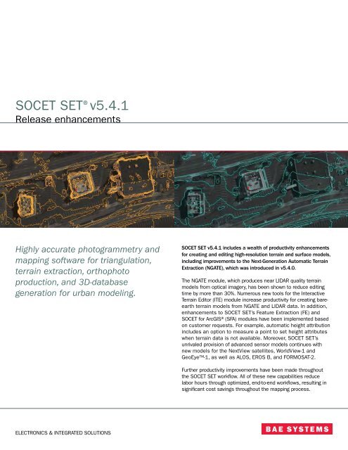
<strong>SOCET</strong> SET®v5.4.1Release enhancementsHighly accurate photogrammetry andmapping software for triangulation,terrain extraction, orthophotoproduction, and 3D-databasegeneration for urban modeling.<strong>SOCET</strong> SET v5.4.1 includes a wealth of productivity enhancementsfor creating and editing high-resolution terrain and surface models,including improvements to the Next-Generation Automatic TerrainExtraction (NGATE), which was introduced in v5.4.0.The NGATE module, which produces near LIDAR quality terrainmodels from optical imagery, has been shown to reduce editingtime by more than 30%. Numerous new tools for the InteractiveTerrain Editor (ITE) module increase productivity for creating bareearthterrain models from NGATE and LIDAR data. In addition,enhancements to <strong>SOCET</strong> SET’s Feature Extraction (FE) and<strong>SOCET</strong> for ArcGIS®(SFA) modules have been implemented basedon customer requests. For example, automatic height attributionincludes an option to measure a point to set height attributeswhen terrain data is not available. Moreover, <strong>SOCET</strong> SET’sunrivaled provision of advanced sensor models continues withnew models for the NextView satellites, WorldView-1 andGeoEye-1, as well as ALOS, EROS B, and FORMOSAT-2.Further productivity improvements have been made throughoutthe <strong>SOCET</strong> SET workflow. All of these new capabilities reducelabor hours through optimized, end-to-end workflows, resulting insignificant cost savings throughout the mapping process.ELECTRONICS & INTEGRATED SOLUTIONS
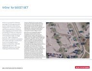
NGATE digital surface model collected over a block of 66 MicrosoftVexcel UltraCam D images in suburban Philadelphia, PA.Advanced sensor modeling for the ALOS PRISM 3-line sensorMosaic– Intensity filter equalizes hotspots corresponding to large-scaleintensity variations, includes vignette filter to equalize radialbrightness variations due to lens fall-off in frame images– New check box allows thinning of terrain within mosaic– Batch processing outputs seamlines for sheets– Condor processing †Feature Extraction (FE) and <strong>SOCET</strong> for ArcGIS (SFA)– Auto-attribution for manually measured object height and heightattributes, such as height above ellipsoid (Z5F), can havenegative values– Closed polylines for polygonal features can be exported toshapefiles– Auto-populate feature for attributes ignores text case ††– Preference to control auto-attribution: on/off– Graphic preferences for drawing vector layers can be set inArcMap®to improve SFA performance and control <strong>SOCET</strong> SETviewportClearFlite®– Universal Data Delivery Format (UDDF) export for FAA/NOAAmode ††– Several issues were resolved for the generation of ClearFlitesurfaces and their representation as surface models, whichrestricted workflows from using the surface for terrain trackingand automatic obstruction identification ††Developer’s Kit (DevKit)– Same <strong>SOCET</strong> SET DevKit for domestic and export purposes †– New DevKit plug-in sensor models allow third-party developers tointegrate multiple custom sensor models with <strong>SOCET</strong> SET– Integrators can use enhanced return error codes for DevKit andbatch processing functions† New in <strong>SOCET</strong> SET v5.4.1†† CorrectedSystem requirements– Microsoft®Windows®XP, Vista**– Sun Microsystems®Solaris 8, 9, 10* <strong>SOCET</strong> SET Digital Point Positioning Data Base (DPPDB) format production module [whichuses MIL-PRF-89034, March 1999 format specifications] and <strong>SOCET</strong> SET ControlledImage Base® (CIB) format production module [which uses MIL-PRF-89041, 15 May 1999format specifications].** Effective October 2007, there are no video cards with associated video drivers thatsupport stereo for Microsoft Vista. In addition, <strong>SOCET</strong> for ArcGIS users should be awarethat ArcGIS® 9.2 does not formally support Vista.
NGATE generated surface model at 15 cm spacing displayedas terrain shaded relief superimposed with 30 cm contours.Source imagery is from the Microsoft Vexcel UltraCam D .Bare-earth terrain model at 15 cm spacing displayed as terrain shaded reliefsuperimposed with 30 cm contours. The NGATE surface on the left was usedas input for ITE. The ITE area tools required the placement of a single polygonaround the buildings. Three separate tools were run on the polygon.The entire editing process took less than one minute.Core– Condor®distributed processing for reduced resolution dataset generation, Automatic Terrain Extraction (ATE), NGATE,and Mosaic, as well as specific functions for DPPDB and CIB®generation* †– Upgrade to Trolltech®Qt®4 for compatibility with <strong>SOCET</strong> <strong>GXP</strong>®– Works with localized versions of Windows®XP (for example,Spanish) ††– Interactive and batch chipping tool creates NITF RPC00B imagefor any input image type– NITF and GeoTIFF information for terrain is preserved during export– Multiple license servers can be defined for query by <strong>SOCET</strong> SETapplications †– Reordering of image bands is maintained for display and imageexport/reformat †– Validated for Microsoft®Vista with certain restrictions** †Advanced Sensor Models (ASM)– ALOS PRISM †– EROS B †– FORMOSAT-2 †– SPOT 5 subscene processed imagery †– GeoEye-1 and WorldView-1 (NextView) in NCDRD format †Multi-Sensor Triangulation (MST)– Improvements to sub-block processing and kappa initializationfor GPS profiles– Sensor Model Factory sensor parameters can be edited ††– New satellite models for ASM can be triangulated †DPPDB and CIB format production*– Compression blocks are set to one shade of gray for cloud cover– Condor processing for TFRD decompression to supportDPPDB and CIB generation, as well as VQ compression for CIBgenerationDataThruWay® (DTW)– Auto-minify works with NTM import ††– JTW SMF 9.2.5Terrain– Terrain precision added to TIN– Enhanced performance for bare-earth processing in TerrainMerge, ATE, NGATE, and ITE modules– GeoTIFF terrain can be imported in both RasterPixellsArea andRasterPixeIlsPoint formats †– Project coordinate system information is included in the terrainheader file for compatibility with <strong>SOCET</strong> <strong>GXP</strong>ATE– Batch processing allows creation of terrain files based on inputcoordinates in the batch processing settings file– Condor processing †NGATE– Technologically advanced module for automatic terraingeneration– Works with all supported sensor and image types– Does not assume that terrain is flat within the matching window– Performs image matching on every pixel, which results in dataredundancy, enabling consistency checking and improvedblunder detection– Uses hybrid approach from image correlation (area-matching)and edge-matching methodologies for optimal matching results– Back matching is on by default– Options to control performance and accuracy– Condor processing †ITE– New tools for bare-earth processing †– ITE Post Editor shows elevation, Figure-of-Merit (FOM), andprecision– Optional feathering for the Plane Fill tool †– Feature codes can be added to breaklines †– Polygons are maintained for area tools, which allows the user toswitch from area editing to geomorphic and/or post editing, andthen back to area editing, using the same extracted polygon onthe edited data with a new area tool †
For more information on <strong>BAE</strong> <strong>Systems</strong> and <strong>GXP</strong> products:AmericasTelephone (800) 316-9643 | (703) 668-4385Fax (703) 668-4381socetgxp.sales@baesystems.comEurope, Middle East, and AfricaTelephone +44 1223 370023Fax +44 1223 370040socetgxp.emea.sales@baesystems.comAsia, Australia, and Pacific RimTelephone +61 2 6273 0111Fax +61 2 6273 0368socetgxp.asia.sales@baesystems.comwww.baesystems.com/gxpCopyright © 2007 <strong>BAE</strong> <strong>Systems</strong> National Security Solutions Inc. All rights reserved. All trademarks used are property of their respectiveowners. 2610111507 EXPORT CONTROLLED DATA: These commodities, technology, or software are controlled for export in accordancewith the U.S. Export Laws. Diversion contrary to U.S. Law is prohibited. Release of this data sheet is approved as of 11/15/2007. Thisdocument gives only a general description of the product(s) or services offered by <strong>BAE</strong> <strong>Systems</strong> and, except where expressly providedotherwise, shall not form part of any contract. From time to time, changes may be made in the products or conditions of supply.