SOCET GXP® Video Analysis - BAE Systems GXP Geospatial ...
SOCET GXP® Video Analysis - BAE Systems GXP Geospatial ...
SOCET GXP® Video Analysis - BAE Systems GXP Geospatial ...

Create successful ePaper yourself
Turn your PDF publications into a flip-book with our unique Google optimized e-Paper software.
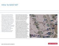
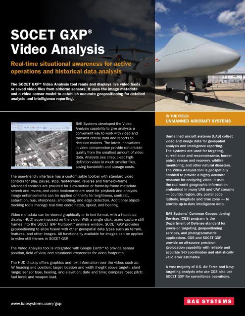
<strong>SOCET</strong> <strong>GXP</strong> ®<strong>Video</strong> <strong>Analysis</strong>Real-time situational awareness for activeoperations and historical data analysisThe <strong>SOCET</strong> <strong>GXP</strong>® <strong>Video</strong> <strong>Analysis</strong> tool reads and displays live video feedsor saved video files from airborne sensors. It uses the image metadataand a video sensor model to establish accurate geopositioning for detailedanalysis and intelligence reporting.<strong>BAE</strong> <strong>Systems</strong> developed the <strong>Video</strong><strong>Analysis</strong> capability to give analysts aconvenient way to work with video andtransmit critical data and reports todecision-makers. The latest innovationsin video compression provide remarkablequality from the smallest amount of videodata. Analysts see crisp, clear, highdefinitionvideo in much smaller files,saving bandwidth and storage costs.The user-friendly interface has a customizable toolbar with standard videocontrols for play, pause, stop, fast-forward, reverse and frame-by-frame.Advanced controls are provided for slow-motion or frame-by-frame metadatasearch and review, and video bookmarks are used for playback and analysis.Image enhancements can be applied on-the-fly for brightness, contrast,saturation, hue, sharpness, smoothing, and edge detection. Additional objecttrackingtools manage real-time coordinates, speed, and bearing.<strong>Video</strong> metadata can be viewed graphically or in text format, with a heads-updisplay (HUD) superimposed on the video. With a single click, users capture stillframes into the <strong>SOCET</strong> <strong>GXP</strong> Multiport analysis window. <strong>SOCET</strong> <strong>GXP</strong> providesgeopositioning to allow fusion with other geospatial data types such as terrain,features, and other images. All functionality available for images can be appliedto video still frames in <strong>SOCET</strong> <strong>GXP</strong>.The <strong>Video</strong> <strong>Analysis</strong> tool is integrated with Google Earth to provide sensorposition, field of view, and situational awareness for video footprints.The HUD display offers graphics and text information over the video, such as:AV heading and position; target location and width (height above target); slantrange; sensor type, bearing, and elevation; date and time; compass rose; pitch;fuel level; and weapon load.IN THE FIELD:Unmanned aircraft systemsUnmanned aircraft systems (UAS) collectvideo and image data for geospatialanalysis and intelligence reporting.The systems are used for targeting,surveillance and reconnaissance, borderpatrol, rescue and recovery, wildfiremonitoring, and other natural disasters.The <strong>Video</strong> <strong>Analysis</strong> tool is geospatiallyenabled to provide a highly accurateresource for analyzing video. It usesthe real-world geographic informationembedded in many UAS and UAV streams— country, region, city, postal code,latitude, longitude and time zone — toprovide up-to-date intelligence data.<strong>BAE</strong> <strong>Systems</strong>’ Common GeopositioningServices (CGS) program is theDepartment of Defense standard forprecision targeting, geopositioningservices, and photogrammetricapplications. CGS and <strong>SOCET</strong> <strong>GXP</strong>provide an all-source precisiongeolocation capability with reliable andaccurate 3-D coordinates and statisticallyvalid error estimates.A vast majority of U.S. Air Force and Navytargeting analysts who use CGS also use<strong>SOCET</strong> <strong>GXP</strong> for surveillance operations.www.baesystems.com/gxp
<strong>Video</strong> analysis is included aspart of the Geo<strong>Analysis</strong> licensetier. An MPEG video decoder andthe <strong>SOCET</strong> <strong>GXP</strong> <strong>Video</strong> <strong>Analysis</strong>license module must be installed.At this time, the functionalityis compatible only with theMicrosoft® Windows® platform.Features<strong>Video</strong> formats supported and ingest methods−−H.264 (MPEG-2), Microsoft® Windows® (.wmv, .asf), and Apple® QuickTime®−−104.5, 601.1 metadata−−User datagram protocol (UDP) streaming video via URL; and video from avideo capture device (USB, PCI)<strong>Video</strong> frame export and video clipping−−Sensor modeling from KLV metadata−−Export still frames in common image formats including NITF−−Select regions of a video to play for further analysis−−Record video from a UDP stream−−Film Roll – a menu of recent frames for export to <strong>SOCET</strong> <strong>GXP</strong>®−−SnapShot – save a video frame as seen on screen, including overlays−−Export video frames with the frame-advanced sensor model to a <strong>SOCET</strong> <strong>GXP</strong>Multiport for further analysis such as: registration, annotation, mensuration,feature extraction, image comparisons, Ortho On-the-Fly, and mosaics<strong>Video</strong> analysis−−Overlay metadata information directly on the screen−−Compass rose capability and graphic representation of telemetry data−−Selectable coordinate system−−Buffer video and interpolate KLV for improved sensor model−−One dimensional time-shift correction to align KLV with video (+/- 2 seconds)Tracking a vehicle.<strong>SOCET</strong> <strong>GXP</strong> and Google Earth integration−−Draw ground footprint and platform location to Google Earth −−Looks at Google Earth from video sensor perspective−−Draw ground footprint and platform location in <strong>SOCET</strong> <strong>GXP</strong> Multiportusing the Snail Trail feature−−Center the <strong>SOCET</strong> <strong>GXP</strong> Multiport on a ground footprint or platform locationusing the Multiport Linking featureTracking−−Track selected object; determine coordinates, establish speed and heading−−Draw object location to the <strong>SOCET</strong> <strong>GXP</strong> Multiport or Google EarthBenefits−−Compliments <strong>BAE</strong> <strong>Systems</strong>’ UAS global offering — a full-service solutionintegrating the air vehicle system, mission control system and controlinfrastructure, focused on reducing cost and operator risk−−Offers access to video files from within the <strong>SOCET</strong> <strong>GXP</strong> application−−Reads standard encoding data derived from streaming video and makes theinformation available to the user−−Converts video to image file formats that support international standards−−Uses advanced-motion imagery technology to create, annotate, and transmitdigital image data−−Supports emerging imagery intelligence operational requirements−−Works with Google Earth to enhance situational awarenessFOR MORE INFORMATION, CONTACT:Americas | Telephone 800 316 9643 or 703 668 4385 | Fax 703 668 4381 | socetgxp.sales@baesystems.comEurope, Middle East, and Africa | Telephone +44 1223 370023 | Fax +44 1223 370040 | socetgxp.emea.sales@baesystems.comAsia, Australia, and Pacific Rim | Telephone +61 0 2 6273 0111 | Fax +61 0 2 6273 0368 | socetgxp.asia.sales@baesystems.com© 2009 <strong>BAE</strong> <strong>Systems</strong> National Security Solutions Inc. All rights reserved. All trademarks used are the property of their respective owners. IS-ISS-092209-224 Approved for public release as of 09/22/2009. This document gives only a general descriptionof the product(s) or service(s) offered by <strong>BAE</strong> <strong>Systems</strong> and, except where expressly provided otherwise, shall not form part of any contract. From time to time, changes may be made in the products or conditions of supply.