10 - University of Leicester
10 - University of Leicester
10 - University of Leicester

You also want an ePaper? Increase the reach of your titles
YUMPU automatically turns print PDFs into web optimized ePapers that Google loves.
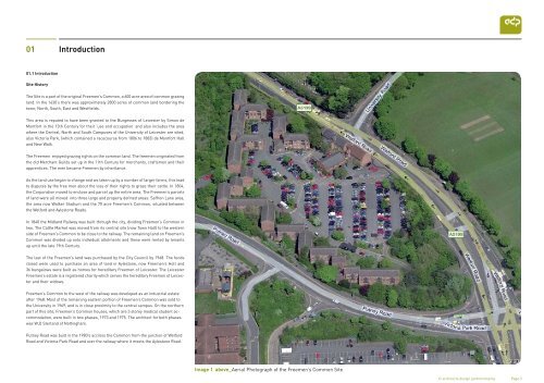
01Introduction01.1 IntroductionSite HistoryThe Site is a part <strong>of</strong> the original Freemen’s Common, a 600 acre area <strong>of</strong> common grazingland. In the 1630’s there was approximately 2800 acres <strong>of</strong> common land bordering thetown; North, South, East and Westfields.This area is reputed to have been granted to the Burgesses <strong>of</strong> <strong>Leicester</strong> by Simon deMontfort in the 13th Century for their ‘use and occupation’ and also includes the areawhere the Central, North and South Campuses <strong>of</strong> the <strong>University</strong> <strong>of</strong> <strong>Leicester</strong> are sited,also Victoria Park, (which contained a racecourse from 1806 to 1883) de Montfort Halland New Walk.The Freemen enjoyed grazing rights on the common land. The freemen originated fromthe old Merchant Guilds set up in the 11th Century for merchants, craftsmen and theirapprentices. The men became Freemen by inheritance.As the land use began to change and ws taken up by a number <strong>of</strong> larger farms, this leadto disputes by the free men about the loss <strong>of</strong> their rights to graze their cattle. In 1804,the Corporation moved to enclose and parcel up the entire area. The Freemen’s parcels<strong>of</strong> land were all moved into three large and properly defined areas: Saffron Lane area,the area now Walker Stadium and the 70 acre Freemen’s Common, situated betweenthe Welford and Aylestone Roads.In 1840 the Midland Railway was built through the city, dividing Freemen’s Common intwo. The Cattle Market was moved from its central site (now Town Hall) to the westernside <strong>of</strong> Freemen’s Common to be close to the railway. The remaining land on Freemen’sCommon was divided up onto individual allotments and these were rented by tenantsup until the late 19th Century.The last <strong>of</strong> the Freemen’s land was purchased by the City Council by 1968. The fundsraised were used to purchase an area <strong>of</strong> land in Aylestone, now Freemen’s Holt and36 bungalows were built as homes for hereditary Freemen <strong>of</strong> <strong>Leicester</strong>. The <strong>Leicester</strong>Freemen’s estate is a registered charity which serves the hereditary Freemen <strong>of</strong> <strong>Leicester</strong>and their widows.Freemen’s Common to the west <strong>of</strong> the railway was developed as an industrial estateafter 1968. Most <strong>of</strong> the remaining eastern portion <strong>of</strong> Freemen’s Common was sold tothe <strong>University</strong> in 1969, and is in close proximity to the central campus. On the northernpart <strong>of</strong> this site, Freemen’s Common houses, which are 3 storey medical student accommodation,were built in two phases, 1973 and 1975. The architect for both phaseswas W,D Sterland <strong>of</strong> Nottingham.Putney Road was built in the 1980’s accross the Common from the junction <strong>of</strong> WelfordRoad and Victoria Park Road and over the railway where it meets the Aylestone Road.Image 1 above_Aerial Photograph <strong>of</strong> the Freemen’s Commen Site© architects design partnership llp Page 5