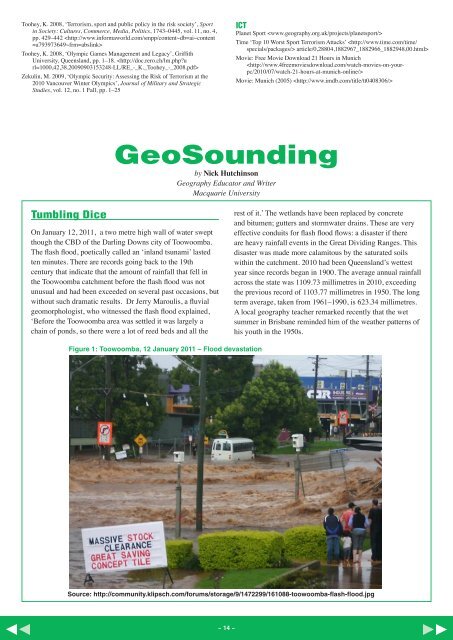
Toohey, K. 2008, ‘Terrorism, sport and public policy in the risk society’, Sportin Society: Cultures, Commerce, Media, Politics, 1743–0445, vol. 11, no. 4,pp. 429–442 Toohey, K. 2008, ‘Olympic Games Management and Legacy’, GriffithUniversity, Queensland, pp. 1–18. Zekulin, M. 2009, ‘Olympic Security: Assessing the Risk of Terrorism at the2010 Vancouver Winter Olympics’, Journal of Military and StrategicStudies, vol. 12, no. 1 Fall, pp. 1–25ICTPlanet Sport Time ‘Top 10 Worst Sport Terrorism Attacks’ article/0,28804,1882967_1882966_1882948,00.html>Movie: Free Movie Download 21 Hours in MunichMovie: Munich (2005) GeoSoundingby Nick HutchinsonGeography Educator and WriterMacquarie UniversityTumbling DiceOn January 12, <strong>2011</strong>, a two metre high wall of water sweptthough the CBD of the Darling Downs city of Toowoomba.The flash flood, poetically called an ‘inland tsunami’ lastedten minutes. There are records going back to the 19thcentury that indicate that the amount of rainfall that fell inthe Toowoomba catchment before the flash flood was notunusual and had been exceeded on several past occasions, butwithout such dramatic results. Dr Jerry Maroulis, a fluvialgeomorphologist, who witnessed the flash flood explained,‘Before the Toowoomba area was settled it was largely achain of ponds, so there were a lot of reed beds and all therest of it.’ The wetlands have been replaced by concreteand bitumen; gutters and stormwater drains. These are veryeffective conduits for flash flood flows: a disaster if thereare heavy rainfall events in the Great Dividing Ranges. Thisdisaster was made more calamitous by the saturated soilswithin the catchment. 2010 had been Queensland’s wettestyear since records began in 1900. The average annual rainfallacross the state was 1109.73 millimetres in 2010, exceedingthe previous record of 1103.77 millimetres in 1950. The longterm average, taken from 1961–1990, is 623.34 millimetres.A local geography teacher remarked recently that the wetsummer in Brisbane reminded him of the weather patterns ofhis youth in the 1950s.Figure 1: Toowoomba, 12 January <strong>2011</strong> – Flood devastationSource: http://community.klipsch.com/forums/storage/9/1472299/161088-toowoomba-flash-flood.jpg~ 14 ~
The Toowoomba flash flood was a disaster, a calamity thathappened to people and their buildings, livelihoods andbelongings. A disaster can also devastate the biophysicalenvironment of a place as a result of a hazardous event. Ataround the same time as the flash flood, muddy floodwaterswere choking Moreton Bay from the Brisbane Riverfloods, bushfires were spreading through Perth suburbsand cyclones were cutting swathes through reefs, forestsand farmlands in Far <strong>No</strong>rth Queensland and north-westWestern Australia. A hazard is different to a disaster. Ahazard is some event or object that is a potential sourceof harm to human life, health, income or possessions.Environmental events such as river floods, earthquakes andmass movements are natural events and only consideredhazardous when human beings or built structures or aspectsof the biophysical environment are affected.It is the idea of ‘potential source of harm’ that introduces thegeography of risk: the tumbling dice, the potential negativeimpact of some future or present event on human activities.Environmental hazards are often seen in terms of risk, orthe probability of the hazard recurring multiplied by theexpected losses. Probability is normally determined fromhistorical trends and records so that we speak of a hundredyear flood referring to the likelihood of a flood, of a specifiedmagnitude, taking place in a certain place, in a given year.This idea may express technical risk but, for the geographer,it is important to expand this idea to include other importantconsiderations. The formulaRisk = f ( probability of occurrence of the event, populationexposed, vulnerability, coping strategies) is a useful one.Obviously such a formula involves a lot of uncertaintybecause each element varies over time and across space andbecause, despite the most sophisticated GIS science, ourknowledge of the components of risk is always incomplete.Concentrating on the time part of the equation if there havebeen 40 cyclones, floods or blizzards in a hundred yearrecord the event is said to have a recurrence interval ofonce every 2.5 years on average (100/40 = 2.5); that is theenvironmental hazard has a 0.4 probability (40/100 = 0.4) ora 0.4 chance of occurring in any given year. The magnitudeof the event is also important, as measured on the Richterscale for the energy released by an earthquake, the windspeeds of a cyclone or the discharge of a river.The floods that affected Brisbane in January, <strong>2011</strong> wereonly a one-in-twenty-five-year event and only the sixthhighest on record, and yet they inflicted much damage,hurt and anger. They could also occur again this year, nextyear, or, the year after. It is a matter of probability. GIShave been developed in Australia that can determine naturalhazard risk ratings at the resolution of individual streetaddresses for bushfire and floods, and, census districts,postcodes or coastal districts for hail storms, earthquakesand tropical cyclones. However, they have to be interpretedwith care. A sound knowledge of mapping techniques andan acquaintance with statistics helps greatly. As does anappreciation of the nature of the environmental hazardbecause sophisticated data that refers to the probability ofexperiencing a flood expressed on a scale from very highrisk (< 1 in 20 average recurrence interval) to negligiblerisk (> 1 in 10 000 years) does not take into account flashflooding; it only relates to river flooding.The geographical models that are used by insurancecompanies are very sophisticated indeed. They use weatherprediction models together with databases of insured valuesand the vulnerability of properties to predict the probabilityof a financial loss. They are so complex because they have toinclude several components: First of all a weather model thatpredicts where how much rain falls. Then you need a floodmodel that distributes the water across the land surface andinto the rivers depending on the level of soil saturation. Then,to calculate the final extent of the flood, you need a modelthat takes into account the existing flood defences, such aslevees, sandbags and weirs, and, the probability that thesedefences will fail.In spite of all this data, even accepting that people understandthe laws of probability, people faced by environmentalhazards do not always pay attention nor do they understandthe predicted event. Even if they are frequently exposed tosound information on environmental hazards they need tobelieve that the hazard really exists and that protection isneeded. All too often, the main problem for people to start totake action about a hazard is that they do not believe it reallyexists. One reason to explain this is that people rely on pastexperience. People simply make rational decisions based onpast experience rather than potential risks.However, the resulting behaviour nearly always follows thesame pattern. They are shocked – often the disaster mayseem unreal, like a dream. They are afraid – about the safetyof family and friends. They are angry – ‘who caused it’ or‘allowed it to happen’. They feel helpless – such crises showus how powerless we are at times, as well as our strengths.They are sad – for the loss of the belief that our world is safeand predictable. And, they are full of shame – for havingbeen exposed as helpless, emotional and needing others.An understanding of the geography of risk can help us makerational decisions based on the probability of environmentalhazards occurring but it can do little to redress the very realhuman emotions that follow from such tragedies.Warringal Publications are producers of excellent resources for teachers and students. For further information on study guides forsenior secondary students in New South Wales and Victoria call (03) 9857 0253 or log on to www.warringalpublications.com.auGeneral Editor: Jo Mawbey, Former Teacher of Geography, Melbourne Girls Grammar SchoolStudent Activities Writer: Nick Hutchinson, Geography Educator and Writer, Macquarie UniversityManaging Editor: Denise Michie