10L. Godin et al. / Journal of Structural Geology xxx (2010) 1e14the potential for superstructural fold geometry modification. Thecharacteristics of Model 43 are found in Table 2.The experiment was run in seven stages (Fig. 8). The first threestages underwent 35% bulk horizontal shortening. Two differenterosion fronts were then cut at the foreland end, a shallow 30 <strong>to</strong>pographic front and a steep 60 front, linked by a transitionalzone in the centre of the model (see Fig. 4a). The model was thenrun in the centrifuge for four additional stages, between which theerosion front angles were re-established (Fig. 8; Stages 4e7). Theangle of the erosion front, with respect <strong>to</strong> the horizontal, has animpact on the amount of rotation of fold axial planes in the<strong>superstructure</strong> and the distance away from the erosion front wherefold geometry is modified. Since erosion commenced after theshortening phase, the first three stage results are similar <strong>to</strong> Model50, with the development of upright <strong>folds</strong> in the <strong>superstructure</strong> andslightly inclined <strong>folds</strong> in the infrastructure (Fig. 8; Stages 1e3).Modification of pre-existing structures during the erosion phasevaries based on the angle of the erosion front (Fig. 8; Stages 4e7).Similar <strong>to</strong> other models, lateral infrastructure flow occurs duringlithostatic adjustments as a result of erosion in the foreland. Duringthe lateral flow, <strong>folds</strong> of the <strong>superstructure</strong> progressively reorient <strong>to</strong>verge <strong>to</strong>wards the <strong>hinterland</strong>; this is more pronounced near thesteep erosion front (Fig. 8; Stages 4e7). The limit between uprightand back-rotated <strong>folds</strong> is farther <strong>to</strong>wards the <strong>hinterland</strong> in thepresence of a shallower erosion front (w30 ), compared <strong>to</strong> a steeperosion front (w60 ; Fig. 8). A steep erosion front appears <strong>to</strong> favoura more localised zone of <strong>superstructure</strong> fold modification, near theforeland erosion front.5. Discussion5.1. Shortening sequence required for drag foldingLateral flow of the infrastructure, partly coupled <strong>to</strong> the <strong>superstructure</strong>,has been proposed as a mechanism <strong>to</strong> nucleate <strong>folds</strong> inthe lowermost <strong>superstructure</strong> (Carosi et al., 2006; Kellett andGodin, 2009). Models devoid of PDMS at the infrastructure/<strong>superstructure</strong>interface were subjected <strong>to</strong> focused erosion withoutshortening, which produced lateral flow of the infrastructure, butfailed <strong>to</strong> nucleate <strong>folds</strong> in the <strong>superstructure</strong> (Model 47). Themodelling suggests that lateral flow of the infrastructure alonecannot nucleate <strong>folds</strong> at the base of the <strong>superstructure</strong>, contrary <strong>to</strong>the proposition of Carosi et al. (2007) (Fig. 3c). The only successfulway <strong>to</strong> create <strong>folds</strong> in the <strong>superstructure</strong> in the modelling isthrough layer-parallel shortening, as demonstrated in Models 43and 50. The inability of infrastructural flow <strong>to</strong> generate superstructuralfolding may be due <strong>to</strong> a Poiseuille flow-dominatedinfrastructure, whereby lateral movement of the infrastructure isconcentrated in the middle of the channel and the velocitydecreases <strong>to</strong> zero at the channel-bounding detachment (Grujic,2006), minimising any drag effects.5.2. Ductility of the detachmentThe <strong>superstructure</strong> anticlines formed during early shortening, inthe absence of PDMS at the infrastructure interface, are cored byinfrastructure material (Fig. 9a). In the presence of PDMS, however,the infrastructure remains almost planar and horizontal, and onlythe PDMS flows in<strong>to</strong> <strong>superstructure</strong> anticlinal cores (Fig. 9b). Itappears that this early geometry may control the amount oflocalisation and depth of the future detachment.Without the PDMS, the detachment, which forms during thelateral infrastructure flow stage, is marked by a several-millimetrethick (equating <strong>to</strong> several km thick for the pro<strong>to</strong>type) zone ofdecoupling in the upper part of the infrastructure, but below theinfrastructure-filled anticline cores (Fig. 9c). The implication of thisscenario is that part of the early infrastructure becomes incorporatedin the hanging wall of the detachment. Consequently, theremight not be significant metamorphic break across the decouplingfault where the active detachment is sub-horizontal.In contrast, when PDMS is present at the <strong>superstructure</strong>-infrastructureinterface (analogous <strong>to</strong> pooling of melts at the <strong>to</strong>p of theGreater <strong>Himalayan</strong> sequence), the decoupling is strongly localisedwithin the PDMS layer (Fig. 9d). Depending on the original thicknessof the PDMS layer, the detachment might then isolate “pods”of PDMS in the <strong>superstructure</strong> anticlinal cores. It is conceivable inthis case that cores of <strong>superstructure</strong> anticlines formed in the earlystages of <strong>Himalayan</strong> orogenesis (EoceneeOligocene) mightfavourably preserve migmatites, and later act as preferred locationfor pooling of the Miocene granitic bodies that now discontinuouslyappear along the strike of the orogen. It is important <strong>to</strong> notethat the pro<strong>to</strong>type will behave differently, because the model doesnot fac<strong>to</strong>r the cooling, therefore change of rheology, of the melts.As the <strong>superstructure</strong> is decoupling from the infrastructure,the melts (PDMS in the models) will be on a cooling (exhumation)path e hence strengthening. It follows that during exhumation ofFig. 9. Sketches depicting deformation features developed in the foreland-half of Model 50. See Fig. 7 for pho<strong>to</strong>graphs of the experiment. (A) Without polydimethylsiloxane (PDMS)at the <strong>superstructure</strong> (SS)einfrastructure (IS) interface, initial shortening of the model develops buckle <strong>folds</strong> in the SS, while the IS material infills the SS anticlinal cores. (B) SSanticlines are cored by PDMS during early shortening, while the IS remains planar and horizontal, yet vertically thickens. (C) Once horizontal IS flow is triggered by focused forelanderosion (depicted by raining clouds), the ISeSS decoupling zone is localised in the upper part of the IS, and isolates the uppermost IS in the hanging wall of the detachment. (D)When PDMS is present, the detachment is localised within it; the entire IS is then confined <strong>to</strong> the footwall of the detachment, with only part of the PDMS isolated in the hangingwall.Please cite this article in press as: Godin, L., et al., <strong>Himalayan</strong> <strong>hinterland</strong>-<strong>verging</strong> <strong>superstructure</strong> <strong>folds</strong> <strong>related</strong> <strong>to</strong> foreland-directed..., Journal ofStructural Geology (2010), doi:10.1016/j.jsg.2010.09.005
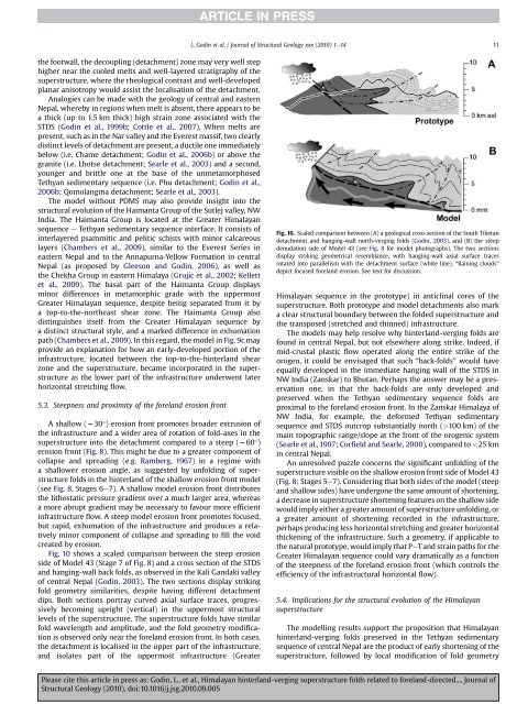
L. Godin et al. / Journal of Structural Geology xxx (2010) 1e14 11the footwall, the decoupling (detachment) zone may very well stephigher near the cooled melts and well-layered stratigraphy of the<strong>superstructure</strong>, where the rheological contrast and well-developedplanar anisotropy would assist the localisation of the detachment.Analogies can be made with the geology of central and easternNepal, whereby in regions when melt is absent, there appears <strong>to</strong> bea thick (up <strong>to</strong> 1.5 km thick) high strain zone associated with theSTDS (Godin et al., 1999b; Cottle et al., 2007). When melts arepresent, such as in the Nar valley and the Everest massif, two clearlydistinct levels of detachment are present, a ductile one immediatelybelow (i.e. Chame detachment; Godin et al., 2006b) or above thegranite (i.e. Lhotse detachment; Searle et al., 2003) and a second,younger and brittle one at the base of the unmetamorphosedTethyan sedimentary sequence (i.e. Phu detachment; Godin et al.,2006b; Qomolangma detachment; Searle et al., 2003).The model without PDMS may also provide insight in<strong>to</strong> thestructural evolution of the Haimanta Group of the Sutlej valley, NWIndia. The Haimanta Group is located at the Greater <strong>Himalayan</strong>sequence e Tethyan sedimentary sequence interface. It consists ofinterlayered psammitic and pelitic schists with minor calcareouslayers (Chambers et al., 2009), similar <strong>to</strong> the Everest Series ineastern Nepal and <strong>to</strong> the Annapurna-Yellow Formation in centralNepal (as proposed by Gleeson and Godin, 2006), as well asthe Chekha Group in eastern Himalaya (Grujic et al., 2002; Kellettet al., 2009). The basal part of the Haimanta Group displaysminor differences in metamorphic grade with the uppermostGreater <strong>Himalayan</strong> sequence, despite being separated from it bya <strong>to</strong>p-<strong>to</strong>-the-northeast shear zone. The Haimanta Group alsodistinguishes itself from the Greater <strong>Himalayan</strong> sequence bya distinct structural style, and a marked difference in exhumationpath (Chambers et al., 2009). In this regard, the model in Fig. 9c mayprovide an explanation for how an early-developed portion of theinfrastructure, located between the <strong>to</strong>p-<strong>to</strong>-the-<strong>hinterland</strong> shearzone and the <strong>superstructure</strong>, became incorporated in the <strong>superstructure</strong>as the lower part of the infrastructure underwent laterhorizontal stretching flow.5.3. Steepness and proximity of the foreland erosion frontA shallow (w30 ) erosion front promotes broader extrusion ofthe infrastructure and a wider area of rotation of fold-axes in the<strong>superstructure</strong> in<strong>to</strong> the detachment compared <strong>to</strong> a steep (w60 )erosion front (Fig. 8). This might be due <strong>to</strong> a greater component ofcollapse and spreading (e.g. Ramberg, 1967) in a regime witha shallower erosion angle, as suggested by unfolding of <strong>superstructure</strong><strong>folds</strong> in the <strong>hinterland</strong> of the shallow erosion front model(see Fig. 8, Stages 6e7). A shallow model erosion front distributesthe lithostatic pressure gradient over a much larger area, whereasa more abrupt gradient may be necessary <strong>to</strong> favour more efficientinfrastructure flow. A steep model erosion front promotes focused,but rapid, exhumation of the infrastructure and produces a relativelyminor component of collapse and spreading <strong>to</strong> fill the voidcreated by erosion.Fig. 10 shows a scaled comparison between the steep erosionside of Model 43 (Stage 7 of Fig. 8) and a cross section of the STDSand hanging-wall back <strong>folds</strong>, as observed in the Kali Gandaki valleyof central Nepal (Godin, 2003). The two sections display strikingfold geometry similarities, despite having different detachmentdips. Both sections portray curved axial surface traces, progressivelybecoming upright (vertical) in the uppermost structurallevels of the <strong>superstructure</strong>. The <strong>superstructure</strong> <strong>folds</strong> have similarfold wavelength and amplitude, and the fold geometry modificationis observed only near the foreland erosion front. In both cases,the detachment is localised in the upper part of the infrastructure,and isolates part of the uppermost infrastructure (GreaterFig. 10. Scaled comparison between (A) a geological cross section of the South Tibetandetachment and hanging-wall north-<strong>verging</strong> <strong>folds</strong> (Godin, 2003), and (B) the steepdenudation side of Model 43 (see Fig. 8 for model pho<strong>to</strong>graphs). The two sectionsdisplay striking geometrical resemblance, with hanging-wall axial surface tracesrotated in<strong>to</strong> parallelism with the detachment surface (white line). “Raining clouds”depict focused foreland erosion. See text for discussion.<strong>Himalayan</strong> sequence in the pro<strong>to</strong>type) in anticlinal cores of the<strong>superstructure</strong>. Both pro<strong>to</strong>type and model detachments also marka clear structural boundary between the folded <strong>superstructure</strong> andthe transposed (stretched and thinned) infrastructure.The models may help resolve why <strong>hinterland</strong>-<strong>verging</strong> <strong>folds</strong> arefound in central Nepal, but not elsewhere along strike. Indeed, ifmid-crustal plastic flow operated along the entire strike of theorogen, it could be envisaged that such “back-<strong>folds</strong>” would haveequally developed in the immediate hanging wall of the STDS inNW India (Zanskar) <strong>to</strong> Bhutan. Perhaps the answer may be a preservationone, in that the back-<strong>folds</strong> are only developed andpreserved when the Tethyan sedimentary sequence <strong>folds</strong> areproximal <strong>to</strong> the foreland erosion front. In the Zanskar Himalaya ofNW India, for example, the deformed Tethyan sedimentarysequence and STDS outcrop substantially north (>100 km) of themain <strong>to</strong>pographic range/slope at the front of the orogenic system(Searle et al., 1997; Corfield and Searle, 2000), compared <strong>to</strong>


