draft revised kaihu river management plan - Northland Regional ...
draft revised kaihu river management plan - Northland Regional ...
draft revised kaihu river management plan - Northland Regional ...
- No tags were found...

You also want an ePaper? Increase the reach of your titles
YUMPU automatically turns print PDFs into web optimized ePapers that Google loves.
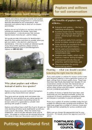
Revised Kaihu Management Plan March 2010old railway station site, and across the football fields and in front of the KaihuHotel, and back into the <strong>river</strong> a few hundred metres downstream of Kaihu. Thegravel load in the <strong>river</strong> needs to be managed for about one kilometre upstreamof Kaihu and three kilometres downstream so as to maintain sufficient capacityin the channel to reduce the risk of an overflow amongst the houses.For two kilometres downstream of Kaihu, the <strong>river</strong> is choked with willow (Salixfragilis) trees. These trees are obstructing the flow, diverting flood flows into thebanks causing streambank erosion and accumulating gravel. During floods theycollect debris, damming the flow and diverting the floodwaters out of the channelacross the floodplain. Streambank erosion is threatening and causing slumpingof State Highway 12 and affecting farmland and orchards on both banks of the<strong>river</strong>.7.3. Ahikiwi to Waihue Road, MamaranuiDownstream of Ahikiwi, as far as the Rotu Bottleneck, the <strong>river</strong> floods out over amuch wider floodplain on which there is clear evidence of a number of older <strong>river</strong>channels, showing where the <strong>river</strong> has meandered backwards and forwardsacross the floodplain. Sediment carried by the <strong>river</strong> has been deposited alongthe banks of these old channels, making this <strong>river</strong>bank land higher than thesurrounding floodplain and clear of water when the rest of the floodplain isinundated.Poplar trees were <strong>plan</strong>ted along the banks of the Kaihu River in the early 1900sto control streambank erosion. Some of these trees remain but are becomingover-mature and need to be removed where they are at risk of falling across the<strong>river</strong>. Others have suckered where their roots have been exposed along the<strong>river</strong>banks and these new tree trunks are impeding the flow of water in thechannel. The soil on the banks through this reach of the <strong>river</strong> is highly erodibleso the removal of these poplars growing in the channel needs to be undertakenin a way that minimises the risk of erosion.7.4. Waihue Road, Mamaranui, to the Rotu BottleneckThe Kaihu River Scheme was constructed in three stages. The section of <strong>river</strong>between Waihue Road and the Rotu Bottleneck, a point at which the floodplainnarrows and the <strong>river</strong> begins to be influenced by the tide, was Stage 3 of theearlier scheme. Downstream of Waihue Road, the gradient of the <strong>river</strong>bedreduces and the meander pattern of the <strong>river</strong> increases, so that as it approachesthe Rotu Bottleneck, the <strong>river</strong> is following a very convoluted course, looping backon itself several times.All trees have been removed from the <strong>river</strong>banks between Waihue Road and theupstream side of the wetland forest immediately upstream of the RotuBottleneck. Grass extends well down the banks of the <strong>river</strong> and when this grassbecomes rank, it traps large volumes of sediment each time there is a fresh inthe <strong>river</strong>.Immediately upstream of the Rotu Bottleneck is a natural ponding area wherethe grade of the <strong>river</strong>bed flattens, sediment is deposited and floodwaters are<strong>Northland</strong> <strong>Regional</strong> Council - 9 -