2011 Edition - Electrical Engineering and Computer Science - The ...
2011 Edition - Electrical Engineering and Computer Science - The ...
2011 Edition - Electrical Engineering and Computer Science - The ...
- No tags were found...

Create successful ePaper yourself
Turn your PDF publications into a flip-book with our unique Google optimized e-Paper software.
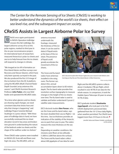
<strong>The</strong> Center for the Remote Sensing of Ice Sheets (CReSIS) is working tobetter underst<strong>and</strong> the dynamics of the world's ice sheets, their effect onsea level rise, <strong>and</strong> the subsequent impact on society.CReSIS Assists in Largest Airborne Polar Ice SurveyCReSIS once again participatedin NASA’s Operation IceBridgemission this fall. IceBridge, thelargest airborne survey of ice at thepolar regions, marked its third year inthe six-year reconnaissance project.An international team of researchersmeasured Antarctica's polar ice sheets <strong>and</strong>sea ice to help forecast how the ice sheetswill respond to changes in climate."We imaged an ice rift in formation onPine Isl<strong>and</strong> Glacier <strong>and</strong> flew surveys overRecovery <strong>and</strong> Slessor Glaciers, which haveonly been sparsely surveyed in the past.We also produced the first 3-D image ofthe ice bottom from the DC-8 platform,using the MCoRDS [Multi-Channel RadarDepth Sounder] array antennas thisseason," said CReSIS Assistant ResearchProfessor John Paden, who was fieldleader <strong>and</strong> operated the MCoRDS radar."At a time when glaciers <strong>and</strong> ice sheetsare showing rapid changes, we needconsistent data that shows how <strong>and</strong>why that change is happening," saidIceBridge Project Scientist MichaelStudinger in a press release. "With threeyears of IceBridge data in h<strong>and</strong>, we havesuccessfully continued the ice sheetelevation record in key areas <strong>and</strong> brokennew ground in underst<strong>and</strong>ing the natureof the bedrock under ice sheets <strong>and</strong> theshape of the seafloor under ice shelves."Three CReSIS radar systems were installedon NASA’s DC-8 aircraft <strong>and</strong> flown overhigh risk areas. <strong>The</strong> MCoRDS, with anantenna mountedunderneath thefuselage, measuredthe thickness of the icesheet. It can be used todetect if liquid existsat the base of the icesheet. <strong>The</strong> presenceof liquid couldgreatly accelerate themovement of the icesheets.<strong>The</strong> Snow <strong>and</strong> Ku-b<strong>and</strong>radars have antennasinstalled in the wingroots. <strong>The</strong> former c<strong>and</strong>etect thin, annualaccumulation layers down to 60 metersdepth. <strong>The</strong> Ku-b<strong>and</strong> radar provides fineresolution surface topography to measurechanges in the height of the ice sheetsover time. <strong>The</strong> Ku-b<strong>and</strong> radar is used tovalidate <strong>and</strong> better underst<strong>and</strong> Cryosat-2satellite radar measurements.EECS doctoral student Ben Panzer, whoran the Snow <strong>and</strong> Ku-b<strong>and</strong> radars, saysthe team doubled their sea ice flights—sixthis time. Sea ice thickness provides anindication of the stability of the Antarcticsea ice pack from year to year. <strong>The</strong> radarsmeasure the snow thickness on the seaice.Depending on weather conditions, themissions were flown at low altitudes(1,000 to 2,000 feet above the surface).<strong>The</strong> Snow <strong>and</strong> Ku-b<strong>and</strong> radars collectabout 400 gigabytes of raw data for eachEECS doctoral student Ben Panzer (right) discusses research with NASA's JohnSonntag as they fly over Pine Isl<strong>and</strong> Glacier in West Antarctica.Photo courtesy of NASAflight <strong>and</strong> the MCoRDS systems collectsabout 2 terabytes (TB) per flight, whichresulted in over 40 TB of raw data for thewhole season. In comparison, it took theHubble Space Telescope 20 years to amass45 TB of data.EECS graduate student ShashankaJagarlapudi, who took part in his firstCReSIS deployment, processed datagathered from the 10-12 hour daily flights,when weather permitted. <strong>The</strong> CReSIS teamlogged more than 210 hours in the air. •Jennifer Salva <strong>and</strong> Shawn Schaller contributedto this article.EECS News <strong>2011</strong> 27