Coastal Upwelling - Monterey Bay California
Coastal Upwelling - Monterey Bay California
Coastal Upwelling - Monterey Bay California

You also want an ePaper? Increase the reach of your titles
YUMPU automatically turns print PDFs into web optimized ePapers that Google loves.
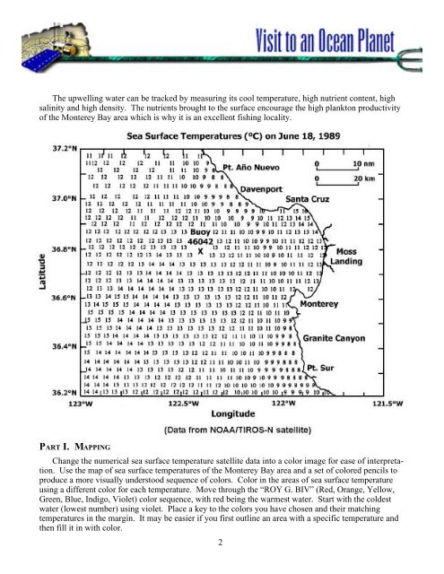
The upwelling water can be tracked by measuring its cool temperature, high nutrient content, highsalinity and high density. The nutrients brought to the surface encourage the high plankton productivityof the <strong>Monterey</strong> <strong>Bay</strong> area which is why it is an excellent fishing locality.PART I. MAPPINGChange the numerical sea surface temperature satellite data into a color image for ease of interpretation.Use the map of sea surface temperatures of the <strong>Monterey</strong> <strong>Bay</strong> area and a set of colored pencils toproduce a more visually understood sequence of colors. Color in the areas of sea surface temperatureusing a different color for each temperature. Move through the “ROY G. BIV” (Red, Orange, Yellow,Green, Blue, Indigo, Violet) color sequence, with red being the warmest water. Start with the coldestwater (lowest number) using violet. Place a key to the colors you have chosen and their matchingtemperatures in the margin. It may be easier if you first outline an area with a specific temperature andthen fill it in with color.2