

Geology and Resource Assessment of the Venezuelan ... - USGS
Geology and Resource Assessment of the Venezuelan ... - USGS
Geology and Resource Assessment of the Venezuelan ... - USGS

Create successful ePaper yourself
Turn your PDF publications into a flip-book with our unique Google optimized e-Paper software.
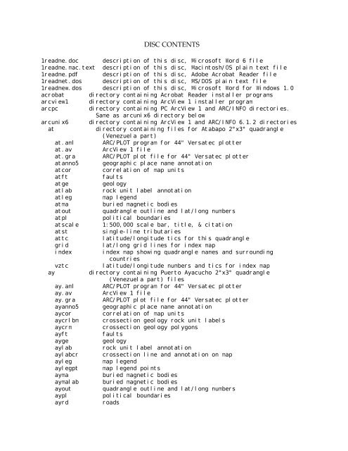
DISC CONTENTS<br />
1readme.doc description <strong>of</strong> this disc, Micros<strong>of</strong>t Word 6 file<br />
1readme.mac.text description <strong>of</strong> this disc, Macintosh/OS plain text file<br />
1readme.pdf description <strong>of</strong> this disc, Adobe Acrobat Reader file<br />
1readmet.dos description <strong>of</strong> this disc, MS/DOS plain text file<br />
1readmew.dos description <strong>of</strong> this disc, Micros<strong>of</strong>t Word for Windows 1.0<br />
acrobat directory containing Acrobat Reader installer programs<br />
arcview1 directory containing ArcView 1 installer program<br />
arcpc directory containing PC ArcView 1 <strong>and</strong> ARC/INFO directories.<br />
Same as arcunix6 directory below<br />
arcunix6 directory containing ArcView 1 <strong>and</strong> ARC/INFO 6.1.2 directories<br />
at directory containing files for Atabapo 2°x3° quadrangle<br />
(Venezuela part)<br />
at.aml ARC/PLOT program for 44" Versatec plotter<br />
at.av ArcView 1 file<br />
at.gra ARC/PLOT plot file for 44" Versatec plotter<br />
atanno5 geographic place name annotation<br />
atcor correlation <strong>of</strong> map units<br />
atft faults<br />
atge geology<br />
atlab rock unit label annotation<br />
atleg map legend<br />
atma buried magnetic bodies<br />
atout quadrangle outline <strong>and</strong> lat/long numbers<br />
atpl political boundaries<br />
atscale 1:500,000 scale bar, title, & citation<br />
atst single-line tributaries<br />
attc latitude/longitude tics for this quadrangle<br />
grid lat/long grid lines for index map<br />
index index map showing quadrangle names <strong>and</strong> surrounding<br />
countries<br />
vztc latitude/longitude numbers <strong>and</strong> tics for index map<br />
ay directory containing Puerto Ayacucho 2°x3° quadrangle<br />
(Venezuela part) files<br />
ay.aml ARC/PLOT program for 44" Versatec plotter<br />
ay.av ArcView 1 file<br />
ay.gra ARC/PLOT plot file for 44" Versatec plotter<br />
ayanno5 geographic place name annotation<br />
aycor correlation <strong>of</strong> map units<br />
aycrlbm crossection geology rock unit labels<br />
aycrm crossection geology polygons<br />
ayft faults<br />
ayge geology<br />
aylab rock unit label annotation<br />
aylabcr crossection line <strong>and</strong> annotation on map<br />
ayleg map legend<br />
aylegpt map legend points<br />
ayma buried magnetic bodies<br />
aymalab buried magnetic bodies<br />
ayout quadrangle outline <strong>and</strong> lat/long numbers<br />
aypl political boundaries<br />
ayrd roads


