Further reading and background information on the Afon Conwy
Further reading and background information on the Afon Conwy
Further reading and background information on the Afon Conwy

You also want an ePaper? Increase the reach of your titles
YUMPU automatically turns print PDFs into web optimized ePapers that Google loves.
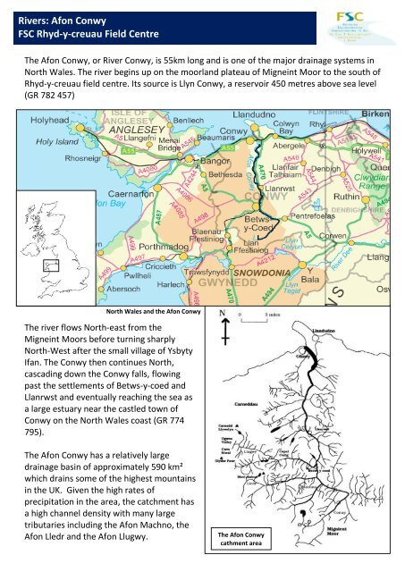
Rivers: Af<strong>on</strong> C<strong>on</strong>wyFSC Rhyd-y-creuau Field CentreThe Af<strong>on</strong> C<strong>on</strong>wy, or River C<strong>on</strong>wy, is 55km l<strong>on</strong>g <str<strong>on</strong>g>and</str<strong>on</strong>g> is <strong>on</strong>e of <strong>the</strong> major drainage systems inNorth Wales. The river begins up <strong>on</strong> <strong>the</strong> moorl<str<strong>on</strong>g>and</str<strong>on</strong>g> plateau of Migneint Moor to <strong>the</strong> south ofRhyd-y-creuau field centre. Its source is Llyn C<strong>on</strong>wy, a reservoir 450 metres above sea level(GR 782 457)North Wales <str<strong>on</strong>g>and</str<strong>on</strong>g> <strong>the</strong> Af<strong>on</strong> C<strong>on</strong>wyThe river flows North-east from <strong>the</strong>Migneint Moors before turning sharplyNorth-West after <strong>the</strong> small village of YsbytyIfan. The C<strong>on</strong>wy <strong>the</strong>n c<strong>on</strong>tinues North,cascading down <strong>the</strong> C<strong>on</strong>wy falls, flowingpast <strong>the</strong> settlements of Betws-y-coed <str<strong>on</strong>g>and</str<strong>on</strong>g>Llanrwst <str<strong>on</strong>g>and</str<strong>on</strong>g> eventually reaching <strong>the</strong> sea asa large estuary near <strong>the</strong> castled town ofC<strong>on</strong>wy <strong>on</strong> <strong>the</strong> North Wales coast (GR 774795).The Af<strong>on</strong> C<strong>on</strong>wy has a relatively largedrainage basin of approximately 590 km²which drains some of <strong>the</strong> highest mountainsin <strong>the</strong> UK. Given <strong>the</strong> high rates ofprecipitati<strong>on</strong> in <strong>the</strong> area, <strong>the</strong> catchment hasa high channel density with many largetributaries including <strong>the</strong> Af<strong>on</strong> Machno, <strong>the</strong>Af<strong>on</strong> Lledr <str<strong>on</strong>g>and</str<strong>on</strong>g> <strong>the</strong> Af<strong>on</strong> Llugwy.The Af<strong>on</strong> C<strong>on</strong>wycathment area
Rivers: Af<strong>on</strong> C<strong>on</strong>wyFSC Rhyd-y-creuau Field CentreYsbyty IfanLlyn C<strong>on</strong>wyAf<strong>on</strong> C<strong>on</strong>wyNant-y-brwynOS map extract of <strong>the</strong> upper courses of <strong>the</strong> Af<strong>on</strong> C<strong>on</strong>wy in <strong>the</strong> Migneint Moors. The main channel flows South-West to North-EastGeology <str<strong>on</strong>g>and</str<strong>on</strong>g> soils <strong>on</strong> <strong>the</strong> Migneint MoorMigneint Moor c<strong>on</strong>sists mainly of siltst<strong>on</strong>es <str<strong>on</strong>g>and</str<strong>on</strong>g> mudst<strong>on</strong>es from <strong>the</strong> Nant Ffranc<strong>on</strong>subgroup (Upper Ordovician), some of which have been metamorphosed into slate. Thisbedrock is of an acidic, impermeable character, directly influencing catchment dynamics.The cold c<strong>on</strong>diti<strong>on</strong>s at this altitude <str<strong>on</strong>g>and</str<strong>on</strong>g> <strong>the</strong> saturated soils encourage <strong>the</strong> development ofpeat soils, especially after <strong>the</strong> large scale deforestati<strong>on</strong> of <strong>the</strong> area. Peat soil ischaracterised by large accumulati<strong>on</strong>s of partially decayed plant matter due to a lack ofoxygen in <strong>the</strong> soil, delaying decompositi<strong>on</strong> at that locati<strong>on</strong>. A report by <strong>the</strong> Internati<strong>on</strong>alUni<strong>on</strong> for <strong>the</strong> C<strong>on</strong>servati<strong>on</strong> of Nature (IUCN) has estimated that <strong>the</strong> UK's peatl<str<strong>on</strong>g>and</str<strong>on</strong>g>s <str<strong>on</strong>g>and</str<strong>on</strong>g>peatbogs lock in about 3 billi<strong>on</strong> t<strong>on</strong>nes of CO₂, <str<strong>on</strong>g>and</str<strong>on</strong>g> are a far more significant carb<strong>on</strong> storethan <strong>the</strong> UK’s forests.The impermeable bedrock of <strong>the</strong> Migneints causes an increased rate of soil saturati<strong>on</strong> insince water cannot percolate fur<strong>the</strong>r down The saturated peat soils mean that infiltrati<strong>on</strong>rates are very low, increasing <strong>the</strong> amount of overl<str<strong>on</strong>g>and</str<strong>on</strong>g> flow <str<strong>on</strong>g>and</str<strong>on</strong>g> reducing <strong>the</strong> lag time for <strong>the</strong>river. The geology <str<strong>on</strong>g>and</str<strong>on</strong>g> soil combined with high rainfall <str<strong>on</strong>g>and</str<strong>on</strong>g> a lack of trees means that riverlevels of <strong>the</strong> C<strong>on</strong>wy in this upper catchment area can change very quickly after rainfallevents.
Rivers: Af<strong>on</strong> C<strong>on</strong>wyFSC Rhyd-y-creuau Field CentreA stratified sampling strategy is comm<strong>on</strong>ly used <strong>on</strong> <strong>the</strong> Af<strong>on</strong> C<strong>on</strong>wy to select sites forinvestigati<strong>on</strong>s. This sampling strategy uses Strahler’s stream order classificati<strong>on</strong> to choosesuccessive sites downstream.Strahler's (1957) stream order system is asimple method modified from Hort<strong>on</strong>’sclassificati<strong>on</strong> system (1945). Streamsecti<strong>on</strong>s are classified based <strong>on</strong> <strong>the</strong>number of tributaries upstream.Strahler’s stream order system 1957A stream with no tributaries is c<strong>on</strong>sidereda first order stream. When two streamorders of n meet <strong>the</strong>y are <strong>the</strong>ncategorised as stream order n+1.The Nant y brwynThe first data normally collected by studentsis at approximately 400m above sea-level <strong>on</strong><strong>the</strong> small tributary called Nant y Brwyn withstream orders 1 & 2 (GR 792 453). This seriesof small tributaries lie at <strong>the</strong> bottom of asmall v-shaped notch <str<strong>on</strong>g>and</str<strong>on</strong>g> displays somecharacteristics typical of an upl<str<strong>on</strong>g>and</str<strong>on</strong>g> streamincluding <strong>the</strong> v-shape of <strong>the</strong> valley, narrowvalley bottom with no developedfloodplain, interlocking spurs, turbulentwater with step-pool sequences, steepchannel gradient <str<strong>on</strong>g>and</str<strong>on</strong>g> large, angular bedload.Small first order stream <strong>on</strong> <strong>the</strong> Nant y brwynFirst order channel <strong>on</strong> <strong>the</strong> Nant y brwynThese sites have good opportunities toobserve <strong>the</strong> bedrock geology with clearexposures left behind after <strong>the</strong> down cuttingof <strong>the</strong> river. In additi<strong>on</strong> to <strong>the</strong> slate, whiteQuartz, an abundant mineral comm<strong>on</strong>lyfound in Wales, is easily identifiable. TheQuartz mineral c<strong>on</strong>stituents (mainly Silica<str<strong>on</strong>g>and</str<strong>on</strong>g> Oxygen) were carried into <strong>the</strong> rockweaknesses in a heated liquid soluti<strong>on</strong> where<strong>the</strong>y crystallised to form veins al<strong>on</strong>g joints orbedding planes.Sec<strong>on</strong>d order channel <strong>on</strong> <strong>the</strong> Nant y brwyn
Rivers: Af<strong>on</strong> C<strong>on</strong>wyFSC Rhyd-y-creuau Field CentreNant-y-brwyn.Stream orders 1 & 2Upper C<strong>on</strong>wy. Stream order 3OS map extract of <strong>the</strong> Migneint Moor with <strong>the</strong> Nant y brwyn <str<strong>on</strong>g>and</str<strong>on</strong>g> Af<strong>on</strong> C<strong>on</strong>wyThe next site for datacollecti<strong>on</strong> is usually located atapproximately 380 metresabove sea-level justdownstream of <strong>the</strong>c<strong>on</strong>fluence between <strong>the</strong>Nant-y-brwyn <str<strong>on</strong>g>and</str<strong>on</strong>g> <strong>the</strong> Af<strong>on</strong>C<strong>on</strong>wy with a stream order of3 (GR 793 447).This site is unusual for <strong>the</strong>upper course of a river as itdisplays characteristics youwould more likely expect in arivers middle to lower course,such as a small but developedfloodplain <str<strong>on</strong>g>and</str<strong>on</strong>g> relativelylarge, regular <str<strong>on</strong>g>and</str<strong>on</strong>g> sinuousme<str<strong>on</strong>g>and</str<strong>on</strong>g>ers with river cliffs <str<strong>on</strong>g>and</str<strong>on</strong>g>graded slip-off slopes.This can be in part explained by <strong>the</strong>areas relatively recent past when largeaccumulati<strong>on</strong>s of glacial ice built up toform an ice cap centred over <strong>the</strong>Migneint Moors.This ice cap spilled outwards in alldirecti<strong>on</strong>s filling a number of glacialtroughs in <strong>the</strong> area. Previously,scientists believed this ice cap was largeenough to overtop <strong>the</strong> mountains to <strong>the</strong>North but fur<strong>the</strong>r study has refuted this<strong>the</strong>ory. Enough ice accumulated in <strong>the</strong>mountain cwms to account for <strong>the</strong> icefeatures in <strong>the</strong>se areas.C<strong>on</strong>fluence between <strong>the</strong> Nant y brwyn <str<strong>on</strong>g>and</str<strong>on</strong>g> <strong>the</strong> Af<strong>on</strong> C<strong>on</strong>wyHowever given <strong>the</strong> significant accumulati<strong>on</strong> of ice, relatively uniform siltst<strong>on</strong>e geology <str<strong>on</strong>g>and</str<strong>on</strong>g><strong>the</strong> lack of resistant peaks in <strong>the</strong> Migneints it is likely that <strong>the</strong> area was completely coveredduring <strong>the</strong> last glacial maximum giving <strong>the</strong> flattened, rolling appearance seen today withassociated river features.
Rivers: Af<strong>on</strong> C<strong>on</strong>wyFSC Rhyd-y-creuau Field CentreStudents <strong>on</strong> Migneint Moor sampling <strong>on</strong> <strong>the</strong> upper Af<strong>on</strong> C<strong>on</strong>wyGraded depositi<strong>on</strong> <strong>on</strong> a slip-off slope. Af<strong>on</strong> C<strong>on</strong>wyEven though <strong>the</strong> features of<strong>the</strong> upper C<strong>on</strong>wy arecuriously located <strong>the</strong>y dopossess great potential forobserving key river l<str<strong>on</strong>g>and</str<strong>on</strong>g>formssuch as well developedme<str<strong>on</strong>g>and</str<strong>on</strong>g>ers.Me<str<strong>on</strong>g>and</str<strong>on</strong>g>er <strong>on</strong> <strong>the</strong> Af<strong>on</strong> C<strong>on</strong>wy. Note <strong>the</strong> river cliff <str<strong>on</strong>g>and</str<strong>on</strong>g> slip-off slopeAfter heavy rain <str<strong>on</strong>g>and</str<strong>on</strong>g>depositi<strong>on</strong>, slip-off slopesdisplay excellent gradingshowing how river energy<str<strong>on</strong>g>and</str<strong>on</strong>g> sediment size interact toorganise or ‘sort’ deposits ina fluvial envir<strong>on</strong>ment.‘Grading’ or ‘sorting’ refers to sediment of similar size being deposited in <strong>the</strong> same locati<strong>on</strong>due to available energy. <str<strong>on</strong>g>Fur<strong>the</strong>r</str<strong>on</strong>g> up <strong>the</strong> slip-off slope nearest <strong>the</strong> channel bank, watervelocity is low due to fricti<strong>on</strong>. Only small calibre sediment can be transported <str<strong>on</strong>g>and</str<strong>on</strong>g>deposited in this low energy envir<strong>on</strong>ment. Lower down <strong>the</strong> slip-off slope, towards <strong>the</strong>channel centre, fricti<strong>on</strong> decreases <str<strong>on</strong>g>and</str<strong>on</strong>g> velocity increases as <strong>the</strong> water gets deeper. Given<strong>the</strong> greater amount of available energy, larger bedload can be transported <str<strong>on</strong>g>and</str<strong>on</strong>g> deposited inthis locati<strong>on</strong>.
Rivers: Af<strong>on</strong> C<strong>on</strong>wyFSC Rhyd-y-creuau Field CentreThe Af<strong>on</strong> C<strong>on</strong>wy differs from a <strong>the</strong>oretical l<strong>on</strong>gprofile showing two distinct ‘knick points’ al<strong>on</strong>g it’scourse, <strong>the</strong> first is located 2-3km upstream of <strong>the</strong>village Ysbyty Ifan <str<strong>on</strong>g>and</str<strong>on</strong>g> <strong>the</strong> sec<strong>on</strong>d is located 3-4kmupstream of Betws-y-coed at C<strong>on</strong>wy Falls.These knick points are believed to have formed afterlarge glaciers met from c<strong>on</strong>necting valleys in eachlocati<strong>on</strong>, rapidly scouring deeper troughs at thosepoints due to an abrupt increase in ice volume.C<strong>on</strong>sequently, steps were left in <strong>the</strong> channel profile‘rejuvenating’ <strong>the</strong> river at <strong>the</strong>se points.Part of <strong>the</strong> first knick point <strong>on</strong> <strong>the</strong> Af<strong>on</strong> C<strong>on</strong>wyYsbyty IfanC<strong>on</strong>wy FallsL<strong>on</strong>g profile of <strong>the</strong> Af<strong>on</strong> C<strong>on</strong>wy showing two distinct ‘knickpoints’ at Ysbyty Ifan <str<strong>on</strong>g>and</str<strong>on</strong>g> C<strong>on</strong>wy Falls. Source: MemoryMapO<strong>the</strong>r factors may well have influenced<strong>the</strong> creati<strong>on</strong> of <strong>the</strong>se steps such asdifferences in geology (C<strong>on</strong>wy Falls cutsthrough a volcanic ash flow tuffsurrounded upstream <str<strong>on</strong>g>and</str<strong>on</strong>g> downstreamby siltst<strong>on</strong>e <str<strong>on</strong>g>and</str<strong>on</strong>g> mudst<strong>on</strong>e) <str<strong>on</strong>g>and</str<strong>on</strong>g> changesin base level caused by absolute sealevel(Eustatic) changes or rebound ofplates after glacial melt (Isostaticrebound).Both knick points are in a state ofrecessi<strong>on</strong>, with a series of waterfalls<str<strong>on</strong>g>and</str<strong>on</strong>g> rapids slowly moving upstream.C<strong>on</strong>wy Falls – sec<strong>on</strong>d knick point <strong>on</strong> <strong>the</strong> Af<strong>on</strong> C<strong>on</strong>wy
Rivers: Af<strong>on</strong> C<strong>on</strong>wyFSC Rhyd-y-creuau Field CentreYsbyty IfanYsbyty Ifan is <strong>the</strong> first settlement ofany significance moving from sourceto mouth <strong>on</strong> <strong>the</strong> Af<strong>on</strong> C<strong>on</strong>wy. By thispoint <strong>the</strong> river has been joined by anumber of tributaries making it muchlarger.Ysbyty Ifan is normally <strong>the</strong> third siteat which students sample <strong>on</strong> <strong>the</strong>Af<strong>on</strong> C<strong>on</strong>wy.The river at this locati<strong>on</strong> is of streamorder 4 (GR 842 488).The bridge over <strong>the</strong> C<strong>on</strong>wy at <strong>the</strong> village of Ysbyty IfanUntil 1189, <strong>the</strong> village was known as Dôl Gynwal. Then, it came to <strong>the</strong> attenti<strong>on</strong> of <strong>the</strong>Knights of St John, who set up a hospice. The church marks <strong>the</strong> spot where <strong>the</strong> old hospicestood.Upstream of Ysbyty Ifan <strong>the</strong> river channelbecomes significantly steeper for a shortsecti<strong>on</strong> before flattening out back up <strong>on</strong>toMigneint Moor.This is <strong>the</strong> C<strong>on</strong>wy’s first ‘knick point’, likelyto have been caused by <strong>the</strong> meeting oftwo large glaciers in <strong>the</strong> Devensian glacialevent, gaining erosive energy <str<strong>on</strong>g>and</str<strong>on</strong>g>subsequently carving a step in <strong>the</strong>l<str<strong>on</strong>g>and</str<strong>on</strong>g>scape. This step or ‘knick point’ hasbeen receding ever since <str<strong>on</strong>g>and</str<strong>on</strong>g> today youcan see a small gorge as you drive to orfrom <strong>the</strong> Migneint Moors.Nati<strong>on</strong>al Truest properties are protected by reinforced banksThe renewal of a rivers potential energy <str<strong>on</strong>g>and</str<strong>on</strong>g> vertical erosi<strong>on</strong> is called rejuvenati<strong>on</strong>.O<strong>the</strong>r points of interest at Ysbyty Ifan are <strong>the</strong> small floodplain, a river bar forming in <strong>the</strong>low energy envir<strong>on</strong>ment behind <strong>the</strong> bridge <str<strong>on</strong>g>and</str<strong>on</strong>g> <strong>the</strong> first signs of river defences includingreinforced banks.
Rivers: Af<strong>on</strong> C<strong>on</strong>wyFSC Rhyd-y-creuau Field CentreThe C<strong>on</strong>wy Falls is <strong>the</strong> largest series of rapids <str<strong>on</strong>g>and</str<strong>on</strong>g>waterfalls <strong>on</strong> <strong>the</strong> river course fallingapproximately 40m in height over a distance ofapproximately 800m (GR 808 535)The area is classified as a Site of Special ScientificInterest (SSSI) for its rare flora <str<strong>on</strong>g>and</str<strong>on</strong>g> fauna.Formati<strong>on</strong> of <strong>the</strong> gorge <str<strong>on</strong>g>and</str<strong>on</strong>g> knickpoint has beensuggested to originate from <strong>the</strong> large quantities ofice meeting at this point. Valley gl aciers from <strong>the</strong>Lledr <str<strong>on</strong>g>and</str<strong>on</strong>g> Llugwy valley joined <strong>the</strong> C<strong>on</strong>wy valleyglacier around Betws-y-Coed causing aggressiveglacial erosi<strong>on</strong> deepening <strong>the</strong> valley.Hanging valleys were created as a result higherupstream al<strong>on</strong>g <strong>the</strong> Lledr <str<strong>on</strong>g>and</str<strong>on</strong>g> <strong>the</strong> C<strong>on</strong>wy.C<strong>on</strong>wy Falls with a steep-sided gorge.Created as <strong>the</strong> knickpoint retreated over timeSince <strong>the</strong> <strong>the</strong> last glacial event, rejuvenati<strong>on</strong> has been taking place with <strong>the</strong> rivers trying toregrade <strong>the</strong>mselves. So far, <strong>the</strong> C<strong>on</strong>wy has cut back around a kilometre leaving a deepgorge downstream towards Betws-y-Coed. The original valley floor is at <strong>the</strong> height of <strong>the</strong>viewing platform <str<strong>on</strong>g>and</str<strong>on</strong>g> <strong>the</strong> café.Rhyd-y-creuauBy <strong>the</strong> time <strong>the</strong> Af<strong>on</strong> C<strong>on</strong>wy passes<strong>the</strong> Field Studies Centre it has beenjoined by two major tributaries, <strong>the</strong>Af<strong>on</strong> Machno <str<strong>on</strong>g>and</str<strong>on</strong>g> <strong>the</strong> Af<strong>on</strong> Lledr<str<strong>on</strong>g>and</str<strong>on</strong>g> will so<strong>on</strong> be joined by <strong>the</strong> Af<strong>on</strong>Llugwy, it’s third major tributary. Allthree of <strong>the</strong>se channels join <strong>the</strong>C<strong>on</strong>wy within approximately 4km ofeach o<strong>the</strong>r. The C<strong>on</strong>wy <strong>on</strong>ly has44m to descend between Rhyd-y-Creuau<strong>the</strong> sea; a distance of approximately 30 kilometres.The Af<strong>on</strong> C<strong>on</strong>wy passing Rhyd-y-creuau<str<strong>on</strong>g>and</str<strong>on</strong>g>River features typical of lower courses are evident here including channel braiding <str<strong>on</strong>g>and</str<strong>on</strong>g>developed pool-riffle sequences.
Rivers: Af<strong>on</strong> C<strong>on</strong>wyFSC Rhyd-y-creuau Field CentreLlanrwstThe town of Llanrwst is <strong>the</strong> largestsettlement so far <strong>on</strong> <strong>the</strong> Af<strong>on</strong> C<strong>on</strong>wy.At this point <strong>the</strong> riveris flowing al<strong>on</strong>g<strong>the</strong> bottom of <strong>the</strong> large C<strong>on</strong>wy Valleyglacial trough where a large floodplainhas developed after <strong>the</strong> last glacialmaximum.P<strong>on</strong>t Fawr bridge in LlanrwstThe C<strong>on</strong>wy has a very ‘flashy’resp<strong>on</strong>se, meaning it resp<strong>on</strong>ds veryquickly to rainfall events with a highpeak discharge.Being so close to <strong>the</strong> river means <strong>the</strong>settlement is vulnerable to flooding.Flood defences are very much in forcehere as <strong>the</strong> river often overflows itsbanks.Since 2004, approximately £7milli<strong>on</strong>has been spent trying to protectproperties in <strong>the</strong> area. Defencesinclude an artificial flood culvert, anew system of levees <str<strong>on</strong>g>and</str<strong>on</strong>g> mountableflood gates.P<strong>on</strong>t Fawr in flood - LlanrwstFlood risk is elevated in Llanrwst as <strong>the</strong> river istidal until half a kilometre downstream. Thismeans that damming of river water can occur athigh tides.A fine example of an oxbow lake can be seenImmediately downstream from Llanrwst. The lakewas formed when <strong>the</strong> me<str<strong>on</strong>g>and</str<strong>on</strong>g>er became sosinuous that it was cut off at some point,probably during a flood event.Oxbow lake near Llanrwst
Rivers: Af<strong>on</strong> C<strong>on</strong>wyFSC Rhyd-y-creuau Field CentreC<strong>on</strong>wy EstuaryThis site is <strong>the</strong> mouth of <strong>the</strong>C<strong>on</strong>wy, 55km from <strong>the</strong> source.The river here is an estuary withmudflats <str<strong>on</strong>g>and</str<strong>on</strong>g> salt marsh.The estuary is a kilometre widein places. The sediment hasbeen broken into smaller pieces<str<strong>on</strong>g>and</str<strong>on</strong>g> is now predominantly silts<str<strong>on</strong>g>and</str<strong>on</strong>g> fine estuarine muds.The town of C<strong>on</strong>wy overlooking <strong>the</strong> C<strong>on</strong>wy estuaryThe river itself takes its name from<strong>the</strong> castled town it passes <strong>on</strong> itsfinal stretch before it flows into <strong>the</strong>Irish sea.Looking upstream from <strong>the</strong> mouth of <strong>the</strong> Af<strong>on</strong> C<strong>on</strong>wyThe estuary area is an importanthabitat for wading birds with anRSBP reserve established in 1991 inc<strong>on</strong>juncti<strong>on</strong> with <strong>the</strong> worlds firstimmersed tube tunnel taking <strong>the</strong>main North Wales A55 directlyunder <strong>the</strong> estuary.The reserve area would have beenreclaimed <str<strong>on</strong>g>and</str<strong>on</strong>g> grazed had it not been for<strong>the</strong> RSPB <str<strong>on</strong>g>and</str<strong>on</strong>g> <strong>the</strong> local council. Now it isa thriving wildlife haven.Summary:Length – 55 kmSource – Llyn C<strong>on</strong>wy, 450m aslMouth – C<strong>on</strong>wy estuaryMajor tribuataries – Af<strong>on</strong> Machno, Af<strong>on</strong>Lledr, Af<strong>on</strong> LlugwyThe C<strong>on</strong>wy estuary seen from <strong>the</strong> Great Orme