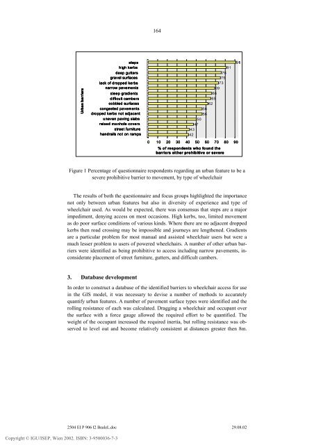
164<strong>Urban</strong> barriersstepshigh kerbsdeep guttersgravel surfaceslack of dropped kerbsnarrow pavementssteep gradientsdifficult camberscobbled surfacescongested pavementsdropped kerbs not adjacentuneven pav<strong>in</strong>g slabsraised manhole coversstreet furniturehandrails not on ramps9181767573696665625656504743420 10 20 30 40 50 60 70 80 90% of respondents who found thebarriers either prohibitive or severeFigure 1 Percentage of questionnaire respondents regard<strong>in</strong>g an urban feature to be asevere prohibitive barrier to movement, by type of wheelchairThe results of both the questionnaire and focus groups highlighted the importancenot only between urban features but also <strong>in</strong> diversity of experience and type ofwheelchair used. As would be expected, there was consensus that steps are a majorimpediment, deny<strong>in</strong>g access on most occasions. High kerbs, too, limited movementas do poor surface conditions of various k<strong>in</strong>ds. Where there are no adjacent droppedkerbs then road cross<strong>in</strong>g may be impossible and journeys are lengthened. Gradientsare a particular problem <strong>for</strong> most manual and assisted wheelchair users but were amuch lesser problem to users of powered wheelchairs. A number of other urban barrierswere identified as be<strong>in</strong>g prohibitive to access <strong>in</strong>clud<strong>in</strong>g narrow pavements, <strong>in</strong>considerateplacement of street furniture, gutters, and difficult cambers.3. Database developmentIn order to construct a database of the identified barriers to wheelchair access <strong>for</strong> use<strong>in</strong> the <strong>GIS</strong> model, it was necessary to devise a number of methods to accuratelyquantify urban features. A number of pavement surface types were identified and theroll<strong>in</strong>g resistance of each was calculated. Dragg<strong>in</strong>g a wheelchair and occupant overthe surface with a <strong>for</strong>ce gauge allowed the required ef<strong>for</strong>t to be quantified. Theweight of the occupant <strong>in</strong>creased the required <strong>in</strong>ertia, but roll<strong>in</strong>g resistance was observedto level out and become relatively consistent at distances greater then 8m.Copyright © IGU/ISEP, Wien 2002. ISBN: 3-9500036-7-32504 EI P 906 I2 BealeL.doc 29.08.02
165The start<strong>in</strong>g <strong>for</strong>ce was, as would be expected, always the highest recorded <strong>for</strong>ce <strong>for</strong>all surfaces. This measure is weight dependant. It was, however, found to be a veryimportant measure, with uneven surfaces caus<strong>in</strong>g the wheelchair to be slowed downand <strong>in</strong> some cases brought to a halt. The range of measured <strong>for</strong>ce was there<strong>for</strong>e acrucial measure, provid<strong>in</strong>g a good <strong>in</strong>dicator <strong>for</strong> surface roughness. The results reflectedthe questionnaire and focus group responses.Dropped kerbs provide cross<strong>in</strong>g po<strong>in</strong>ts <strong>for</strong> wheelchairs across roads and consequentlyhad been identified as be<strong>in</strong>g extremely important to allow<strong>in</strong>g movementaround an urban area. A total of n<strong>in</strong>e factors were identified as be<strong>in</strong>g required to assessa drop kerb and <strong>in</strong>cluded: height, surface, slope, camber, width, orientation,curvature, with bullnose and brickrunners. Collation of this <strong>in</strong><strong>for</strong>mation enabled acomprehensive and efficient method of rank<strong>in</strong>g drop kerbs.The rema<strong>in</strong><strong>in</strong>g urban features to be <strong>in</strong>cluded <strong>in</strong> the digital database (e.g. the locationof steps, ramps and cambers) required only mapp<strong>in</strong>g by location, rather thanquantify<strong>in</strong>g. Many of the urban features were gathered <strong>in</strong> the field, us<strong>in</strong>g a palmcomputer runn<strong>in</strong>g ArcPad <strong>GIS</strong>. This provided an efficient method of mapp<strong>in</strong>g thedata and reduced the error that can often occur dur<strong>in</strong>g data conversion.Initially, a network coverage represent<strong>in</strong>g pedestrian routes around the town centrewas derived us<strong>in</strong>g Ordnance Survey Land-L<strong>in</strong>e data - an enhanced vector dataset, where features are represented as po<strong>in</strong>ts and l<strong>in</strong>es that are digitised and specificallycoded to show 37 layers. A number of issues arise when attempt<strong>in</strong>g to demarcatepavements as a range of different features def<strong>in</strong>es pavement edges (e.g. build<strong>in</strong>goutl<strong>in</strong>es, walls, road edges). In order to provide consistency, pavement centrel<strong>in</strong>eswere manually extracted us<strong>in</strong>g the Ordnance Survey Land-L<strong>in</strong>e data as a backdrop.This removed the need to alter the orig<strong>in</strong>al data whilst allow<strong>in</strong>g the designer to uselocal knowledge to derive a network that best represented the general flow of pedestriansaround the town centre. Us<strong>in</strong>g the Dynamic Segmentation module <strong>in</strong>ARC/INFO ® , l<strong>in</strong>ear measurements were used to def<strong>in</strong>e locations along l<strong>in</strong>ear features.All urban barriers were then associated with the correct measurement along theroute, def<strong>in</strong>ed as l<strong>in</strong>ear measures (e.g. pavement surface) or po<strong>in</strong>t events at measuredlocations (e.g. steps). The routes were assigned a direction along which the measurementsare made, thus, each route must be labelled twice s<strong>in</strong>ce some of the barriersare direction dependent (e.g. slope). The drop kerbs were then stored as turntabledata, thereby allow<strong>in</strong>g the direction of traverse to be significant. Stor<strong>in</strong>g the data us<strong>in</strong>gdynamic segmentation means that the data is stored as a tabular database. Datacan be updated without alter<strong>in</strong>g the network topology.3. Model developmentMAGUS (Modell<strong>in</strong>g <strong>Access</strong> with <strong>GIS</strong> <strong>in</strong> <strong>Urban</strong> Systems) is built entirely with<strong>in</strong>ESRI ArcView ® <strong>GIS</strong>, us<strong>in</strong>g AVENUE programm<strong>in</strong>g language and Dialog De-Copyright © IGU/ISEP, Wien 2002. ISBN: 3-9500036-7-32504 EI P 906 I2 BealeL.doc 29.08.02