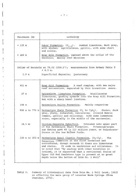
- 6 -II-2.<strong>Geological</strong> Sett<strong>in</strong>gThe known warm spr<strong>in</strong>gs all issue from D<strong>in</strong>antian limestones. Forthe ma<strong>in</strong> Le<strong>in</strong>ster group <strong>of</strong> 11, Fig. 2 shows that they emerge ma<strong>in</strong>ly fromVisean limestones, except the small spr<strong>in</strong>g (No. 1010) at Cash's farmissu<strong>in</strong>g from the underly<strong>in</strong>g Tournaisian. This applies to the warm spr<strong>in</strong>gs<strong>in</strong> Co. Limerick and <strong>in</strong> Co. Clare. The Mallow spr<strong>in</strong>gs and boreholes arealso from the limestone, but are associated with a major thrust zone.Fig. 2 br<strong>in</strong>gs together such geological data as is available fromthe ma<strong>in</strong> area <strong>of</strong> warm spr<strong>in</strong>gs <strong>in</strong> Le<strong>in</strong>ster. Most <strong>of</strong> the area is covered byQuaternary deposits, <strong>of</strong> vary<strong>in</strong>g thickness and nature; rock exposures arepoor. The ma<strong>in</strong> data comes from MacDermot & Sevastopulo (1972), andSheridan (1972), while Turner (1952), Nevill (1957), Bruck (1971) andWilliams & McArdle (1978) have also been studied and relevant data extracted.Data on ~rtiary sills/dykes comes from Sheridan (1972), Selwyn Turner et al(1972) and Byrne et al (1971).The region <strong>of</strong> the warm spr<strong>in</strong>gs lies between the granite, metamorphicsand Silurian <strong>of</strong> the Le<strong>in</strong>ster Caledonian granite massif on its south-east, andthe Ordovician-Silurian Balbriggan and Louth blocks on its north. Here,conglomerates, sandstones and siltstones <strong>of</strong> desertic and fluvio-estur<strong>in</strong>eenvironments were laid down <strong>in</strong> Devonian and <strong>in</strong>to Lower Carboniferous times,as the Tournaisianseas gradually transgressed from the south and south-west,as Clayton & Higgs (1979). It could have been well <strong>in</strong>to Lower Tournaisiantime before mar<strong>in</strong>e limestones began to <strong>in</strong>terdigitate with coastal sandstonesunder the area <strong>of</strong> Fig. 2. By the Upper Tournaisian, shelf limestones withisolated Waulsortian reef mounds were form<strong>in</strong>g under the ma<strong>in</strong> portion <strong>of</strong>Fig. 2. The Waulsortian mounds were more frequent and much thicker to thewest and away to the southwest, to the areas <strong>of</strong> warm spr<strong>in</strong>gs Nos. 2003 and2004; this is shown clearly <strong>in</strong> Figs. 1 and 2 <strong>of</strong> MacDermot & Sevastopulo(1972) . There was a break at the end <strong>of</strong> the Tournaisian, with some upliftand fault<strong>in</strong>g, but marked also by <strong>in</strong>creased mar<strong>in</strong>e transgression, as onto theedges <strong>of</strong> the Le<strong>in</strong>ster granite massif. In the region <strong>of</strong> the Le<strong>in</strong>ster warmspr<strong>in</strong>gs, there was a sharp change to deposition <strong>of</strong> argillaceous limestones<strong>of</strong> bas<strong>in</strong>al facies; the 800 or so metres <strong>of</strong> the Rathmolyon Shale Formation(with pyrite) cut <strong>in</strong> the Trim NO. 1 boreholes is dated as "Cl or younger,rang<strong>in</strong>g up to C2Sl" (Sheridan, 1972, p. 330), and so <strong>of</strong> Lower Visean age.These shales were followed by limestones, <strong>in</strong> part with reefs <strong>of</strong> Viseantype and towards the top <strong>of</strong> the Visean with bedded limestones, argillaceous,with some chert and silica. These limestones are succeeded by Namurianstrata, <strong>of</strong>ten found occurr<strong>in</strong>g as perched syncl<strong>in</strong>es, as at Summerhill (Nevill1957) . The total thickness <strong>of</strong> the Tournaisian + Visean is <strong>of</strong> the order <strong>of</strong>2,220 metres (Sheridan, 1972) plus more than 760 m <strong>of</strong> overly<strong>in</strong>g Namurian(Nevill, 1957). The thickness <strong>of</strong> the underly<strong>in</strong>g Devonian is unknown for thearea <strong>of</strong> Fig. 2.The detailed <strong>in</strong>formation obta<strong>in</strong>ed from the Trim No.1 borehole isvery relevant to the study <strong>of</strong> the rocks from which the warm spr<strong>in</strong>gs issue.The lithology/thicknesses are summarised <strong>in</strong> Table 2. The fact that theboreholes <strong>in</strong>tersected some 4.5 metres <strong>of</strong> an oliv<strong>in</strong>e dolerite dyke or sillat from 740.7 to 745.2 metres below surface is also <strong>of</strong> importance whenconsider<strong>in</strong>g local sources <strong>of</strong> heat with<strong>in</strong> the sedimentary and underly<strong>in</strong>gsequences./ ...
- 7 -Thickness(m)Lithology+ 335 m+ 183 mAgher Formation, (P l- 2). Bedded limestone, dark grey,with shales; agrillaceous, pyritic, with some chertand silica.Bray Hill Formation, exposed above the collar <strong>of</strong> theborehole; ma<strong>in</strong>ly reef micritesCollar <strong>of</strong> Borehole at 79,03 (259.3'); measurements from Rotary Table @+ 4.3 m.l.8m Superficial deposits; Quaternary401 mBray Hill Formation. A reef complex, with two majorreef successions, separated by th<strong>in</strong> transition zones.37 m Rathmolyon Limestone Formation.limestones, grad<strong>in</strong>g upwards <strong>in</strong>tobut with a sharp basal junction.Argillaceousthe Bray Hill Formation,193 m Rathmolyon Oolite Formation. Ma<strong>in</strong>ly oosparites806 m to 770 m Rathmolyon Shale Formation (Cl to C2Sl) . Shales, darkgrey, platy, <strong>in</strong>durated, calcareous; cr<strong>in</strong>oid debriscommon, pyritic and siliceous; with some limestonezones, especially <strong>in</strong> the middle <strong>of</strong> the succession.(4.5 m) Oliv<strong>in</strong>e-Dolerite Dyke/Sill. Intruded <strong>in</strong>to upper part<strong>of</strong> the Rathmolyon Shale Formation. Potassium-argonage dat<strong>in</strong>g gave 65 (+ 11) million years, or PalaeoceneEocene on the New Holmes Scale.330 m to 300 m ~thmolyon Basal Clastic Formation, (Z2-Cl). Theformation commences at the first sandstone bedencountered, though beneath it there are limestonesand shales. It ends <strong>in</strong> sandstones and siltstones. Itis noted that "By analogy with other boreholes <strong>in</strong><strong>Ireland</strong>, it is suspected that a cont<strong>in</strong>ental facies <strong>of</strong>Upper Old Red Sandstone type is present at no greatdepth belmv the bottom <strong>of</strong> Trim No. 1 Well"TABLE 2. Summary <strong>of</strong> lithological data from Trim No. 1 Well (sunk, 1962)as affect<strong>in</strong>g the ma<strong>in</strong> group <strong>of</strong> Le<strong>in</strong>ster Warm Spr<strong>in</strong>gs (fromSheridan, 1972).