AIP amendment 30_APR_2011_TEXT.pdf - Civil Aviation Authority ...
AIP amendment 30_APR_2011_TEXT.pdf - Civil Aviation Authority ...
AIP amendment 30_APR_2011_TEXT.pdf - Civil Aviation Authority ...

Create successful ePaper yourself
Turn your PDF publications into a flip-book with our unique Google optimized e-Paper software.
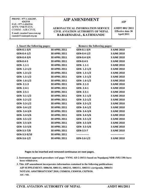
PHONE : 977-1-4262387,4262518FAX : 977-1-4262516AFTN: VNKTYAYXCOMM : AIR CIVILE-mail: cnsatm@mos.com.npcaanais@caanepal.org.np<strong>AIP</strong> AMENDMENTAERONAUTICAL INFORMATION SERVICECIVIL AVIATION AUTHORITY OF NEPALBABARMAHAL, KATHMANDU<strong>AIP</strong>AMDT 001/ <strong>2011</strong>Effective date <strong>30</strong>April <strong>2011</strong>1. Insert the following pages: Remove the following pages:GEN-0.1-3/4 <strong>30</strong> <strong>APR</strong>IL <strong>2011</strong>GEN-0.4-1/2 <strong>30</strong> <strong>APR</strong>IL <strong>2011</strong>GEN-0.4-3/4 <strong>30</strong> <strong>APR</strong>IL <strong>2011</strong>GEN-0.4-5 <strong>30</strong> <strong>APR</strong>IL <strong>2011</strong>GEN- 1.1-1 <strong>30</strong> <strong>APR</strong>IL <strong>2011</strong>GEN- 1.2-1/2 <strong>30</strong> <strong>APR</strong>IL <strong>2011</strong>GEN- 1.3-1/2 <strong>30</strong> <strong>APR</strong>IL <strong>2011</strong>GEN- 1.5-1/2 <strong>30</strong> <strong>APR</strong>IL <strong>2011</strong>GEN- 1.6-1/2 <strong>30</strong> <strong>APR</strong>IL <strong>2011</strong>GEN- 2.1-3 <strong>30</strong> <strong>APR</strong>IL <strong>2011</strong>GEN- 2.4-1 <strong>30</strong> <strong>APR</strong>IL <strong>2011</strong>GEN- 2.5-1 <strong>30</strong> <strong>APR</strong>IL <strong>2011</strong>GEN- 3.1-1/2 <strong>30</strong> <strong>APR</strong>IL <strong>2011</strong>GEN- 3.2-1/2 <strong>30</strong> <strong>APR</strong>IL <strong>2011</strong>GEN- 3.3-1/2 <strong>30</strong> <strong>APR</strong>IL <strong>2011</strong>GEN- 3.4-1/2 <strong>30</strong> <strong>APR</strong>IL <strong>2011</strong>GEN- 3.4-3/4 <strong>30</strong> <strong>APR</strong>IL <strong>2011</strong>GEN- 3.4-5/6 <strong>30</strong> <strong>APR</strong>IL <strong>2011</strong>GEN- 3.5-1/2 <strong>30</strong> <strong>APR</strong>IL <strong>2011</strong>GEN- 3.5-3/4 <strong>30</strong> <strong>APR</strong>IL <strong>2011</strong>GEN- 3.5-5/6 <strong>30</strong> <strong>APR</strong>IL <strong>2011</strong>GEN-3.5-7/8 <strong>30</strong> <strong>APR</strong>IL <strong>2011</strong>GEN-3.5-9/10 <strong>30</strong> <strong>APR</strong>IL <strong>2011</strong>GEN-3.6-1/2 <strong>30</strong> <strong>APR</strong>IL <strong>2011</strong>GEN-0.1-3/4 3 JUNE 2010GEN-0.4-1/2 3 JUNE 2010GEN-0.4-3/4 3 JUNE 2010GEN-0.4-5 3 JUNE 2010GEN- 1.1-1 3 JUNE 2010GEN- 1.2-1/2 3 JUNE 2010GEN- 1.3-1/2 3 JUNE 2010GEN- 1.5-1/2 3 JUNE 2010GEN- 1.6-1/2 3 JUNE 2010GEN- 2.1-3 3 JUNE 2010GEN- 2.4-1 3 JUNE 2010GEN- 2.5-1 3 JUNE 2010GEN- 3.1-1/2 3 JUNE 2010GEN- 3.2-1/2 3 JUNE 2010GEN- 3.3-1/2 3 JUNE 2010GEN- 3.4-1/2 3 JUNE 2010GEN- 3.4-3/4 3 JUNE 2010GEN- 3.4-5/6 3 JUNE 2010GEN- 3.5-1/2 3 JUNE 2010GEN- 3.5-3/4 3 JUNE 2010GEN- 3.5-5/6 3 JUNE 2010GEN-3.5-7 3 JUNE 2010--------------- ----------------GEN-3.6-1/2 3 JUNE 2010Pages to be inserted and removed continuous on next pages.2. Instrument approach procedure (ref page: VNNG AD 2-10/11) based on Nepalgunj NDB (NPJ 3<strong>30</strong>) havebeen withdrawn.3. This <strong>AIP</strong> <strong>amendment</strong> incorporates information contained in the following publications:<strong>AIP</strong> SUPPLEMENT: S006/10, S001/11, S002/11, S003/11, S003/11 corrigenda, S004/11NOTAM: A0167/B0167/C0367 2010, C0368/10, C0369/10, C0370/10.AIC: NILCIVIL AVIATION AUTHORITY OF NEPAL AMDT 001/<strong>2011</strong>
Insert the following pages:ENR- 1.1-1/2 <strong>30</strong> <strong>APR</strong>IL <strong>2011</strong>ENR - 1.1-3/4 <strong>30</strong> <strong>APR</strong>IL <strong>2011</strong>ENR - 1.1-5/6 <strong>30</strong> <strong>APR</strong>IL <strong>2011</strong>ENR - 1.1-7/8 <strong>30</strong> <strong>APR</strong>IL <strong>2011</strong>ENR - 1.1-13/14 <strong>30</strong> <strong>APR</strong>IL <strong>2011</strong>ENR- 1.1-15/16 <strong>30</strong> <strong>APR</strong>IL <strong>2011</strong>ENR- 1.1-17/18 <strong>30</strong> <strong>APR</strong>IL <strong>2011</strong>ENR- 1.2-1/2 <strong>30</strong> <strong>APR</strong>IL <strong>2011</strong>ENR- 1.5-1/2 <strong>30</strong> <strong>APR</strong>IL <strong>2011</strong>ENR- 2.1-1/2 <strong>30</strong> <strong>APR</strong>IL <strong>2011</strong>ENR- 3.1-1/2 <strong>30</strong> <strong>APR</strong>IL <strong>2011</strong>ENR- 3.1-3/4 <strong>30</strong> <strong>APR</strong>IL <strong>2011</strong>ENR- 3.1-5 <strong>30</strong> <strong>APR</strong>IL <strong>2011</strong>ENR- 3.3-1 <strong>30</strong> <strong>APR</strong>IL <strong>2011</strong>ENR- 3.5-1 <strong>30</strong> <strong>APR</strong>IL <strong>2011</strong>ENR- 3.6-1 <strong>30</strong> <strong>APR</strong>IL <strong>2011</strong>ENR- 4.1-1 <strong>30</strong> <strong>APR</strong>IL <strong>2011</strong>ENR- 4.4-1 <strong>30</strong> <strong>APR</strong>IL <strong>2011</strong>ENR- 6-1 <strong>30</strong> <strong>APR</strong>IL <strong>2011</strong>ENR- 6-2 <strong>30</strong> <strong>APR</strong>IL <strong>2011</strong>ENR- 6-3 <strong>30</strong> <strong>APR</strong>IL <strong>2011</strong>Remove the following pages:ENR- 1.1-1/2 3 JUNE 2010ENR - 1.1-3/4 3 JUNE 2010ENR - 1.1-5/6 3 JUNE 2010ENR - 1.1-7/8 3 JUNE 2010ENR - 1.1-13/14 3 JUNE 2010ENR- 1.1-15/16 3 JUNE 2010ENR- 1.1-17/18 3 JUNE 2010ENR- 1.2-1/2 3 JUNE 2010ENR- 1.5-1/2 3 JUNE 2010ENR- 2.1-1/2 3 JUNE 2010ENR- 3.1-1/2 3 JUNE 2010ENR- 3.1-3/4 3 JUNE 2010ENR- 3.1-5 3 JUNE 2010ENR- 3.3-1 3 JUNE 2010ENR- 3.5-1 3 JUNE 2010ENR- 3.6-1 3 JUNE 2010ENR- 4.1-1 3 JUNE 2010ENR- 4.4-1 3 JUNE 2010ENR- 6-1 3 JUNE 2010ENR- 6-2 3 JUNE 2010ENR- 6-3 3 JUNE 2010AD-1.3-1/2 <strong>30</strong> <strong>APR</strong>IL <strong>2011</strong>AD-1.4-1 <strong>30</strong> <strong>APR</strong>IL <strong>2011</strong>VNKT AD 2-1/2 <strong>30</strong> <strong>APR</strong>IL <strong>2011</strong>VNKT AD 2-5/6 <strong>30</strong> <strong>APR</strong>IL <strong>2011</strong>VNKT AD 2-6 <strong>30</strong> <strong>APR</strong>IL <strong>2011</strong>VNKT AD 2-7 <strong>30</strong> <strong>APR</strong>IL <strong>2011</strong>VNKT AD 2-11/12 <strong>30</strong> <strong>APR</strong>IL <strong>2011</strong>VNKT AD 2-15 <strong>30</strong> <strong>APR</strong>IL <strong>2011</strong>VNKT AD 2-18/21 <strong>30</strong> <strong>APR</strong>IL <strong>2011</strong>VNKT AD 2-22 to 2-36 <strong>30</strong> <strong>APR</strong>IL <strong>2011</strong>VNKT AD 2-39 <strong>30</strong> <strong>APR</strong>IL <strong>2011</strong>AD-1.3-1/2 3 JUNE 2010AD-1.4-1 3 JUNE 2010VNKT AD 2-1/2 3 JUNE 2010VNKT AD 2-5/6 3 JUNE 2010VNKT AD 2-6 3 JUNE 2010VNKT AD 2-7 3 JUNE 2010VNKT AD 2-11/12 3 JUNE 2010VNKT AD 2-15 3 JUNE 2010VNKT AD 2-18/21 3 JUNE 2010AIRAC S003/11 10 March, <strong>2011</strong>(ATTACHMENT A-N)CIVIL AVIATION AUTHORITY OF NEPAL AMDT 001/<strong>2011</strong>
Insert the following pages:VNBW AD 2-3/4 <strong>30</strong> <strong>APR</strong>IL <strong>2011</strong>VNBW AD 2-5/6 <strong>30</strong> <strong>APR</strong>IL <strong>2011</strong>VNVT AD 2-1/2 <strong>30</strong> <strong>APR</strong>IL <strong>2011</strong>VNVT AD 2-3/4 <strong>30</strong> <strong>APR</strong>IL <strong>2011</strong>VNVT AD 2-5/6 <strong>30</strong> <strong>APR</strong>IL <strong>2011</strong>VNVT AD 2-9 <strong>30</strong> <strong>APR</strong>IL <strong>2011</strong>VNVT AD 2-10 to 2-19 <strong>30</strong> <strong>APR</strong>IL <strong>2011</strong>VNJP AD 2-3/4 <strong>30</strong> <strong>APR</strong>IL <strong>2011</strong>VNNG AD 2-3/4 <strong>30</strong> <strong>APR</strong>IL <strong>2011</strong>VNNG AD 2-5/6 <strong>30</strong> <strong>APR</strong>IL <strong>2011</strong>VNNG AD 2-9 <strong>30</strong> <strong>APR</strong>IL <strong>2011</strong>VNNG AD 2-10 to 2-16 <strong>30</strong> <strong>APR</strong>IL <strong>2011</strong>VNPK AD 2-3/4 <strong>30</strong> <strong>APR</strong>IL <strong>2011</strong>VNPK AD 2-5/6 <strong>30</strong> <strong>APR</strong>IL <strong>2011</strong>VNPK AD 2-6 <strong>30</strong> <strong>APR</strong>IL <strong>2011</strong>VNPK AD 2-10 <strong>30</strong> <strong>APR</strong>IL <strong>2011</strong>VNSI AD 2-3/4 <strong>30</strong> <strong>APR</strong>IL <strong>2011</strong>VNCG AD 2-1/2 <strong>30</strong> <strong>APR</strong>IL <strong>2011</strong>VNCG AD 2-3/4 <strong>30</strong> <strong>APR</strong>IL <strong>2011</strong>VNCG AD 2-5/6 <strong>30</strong> <strong>APR</strong>IL <strong>2011</strong>AFIS AD 2-1/2 <strong>30</strong> <strong>APR</strong>IL <strong>2011</strong>AFIS AD 2-3/4 <strong>30</strong> <strong>APR</strong>IL <strong>2011</strong>Remove the following pages:VNBW AD 2-3/4 3 JUNE 2010VNBW AD 2-5/6 3 JUNE 2010VNVT AD 2-1/2 3 JUNE 2010VNVT AD 2-3/4 3 JUNE 2010VNVT AD 2-5/6 3 JUNE 2010VNVT AD 2-9 3 JUNE 2010AIRAC S002/11 10 March, <strong>2011</strong>(ATTACHMENT A-G)VNJP AD 2-3/4 3 JUNE 2010VNNG AD 2-3/4 3 JUNE 2010VNNG AD 2-5/6 3 JUNE 2010VNNG AD 2-9 3 JUNE 2010AIRAC S001/11 10 March, <strong>2011</strong>(ATTACHMENT A-G)VNPK AD 2-3/4 3 JUNE 2010VNPK AD 2-5/6 3 JUNE 2010VNPK AD 2-6 3 JUNE 2010----------------- ----------------VNSI AD 2-3/4 3 JUNE 2010----------------- --------------------------------- --------------------------------- ----------------AFIS AD 2-1/2 3 JUNE 2010AFIS AD 2-3/4 3 JUNE 2010CIVIL AVIATION AUTHORITY OF NEPAL AMDT 001/<strong>2011</strong>
<strong>AIP</strong> NEPALGEN 0.1-3<strong>30</strong> April,<strong>2011</strong>3.2. Regular Amendment IntervalRegular <strong>amendment</strong>s to the <strong>AIP</strong> will be issued once in a year in the month of April.4. Service to contact in case of detected <strong>AIP</strong> errors or omissionsIn the compilation of the <strong>AIP</strong>, care has been taken to ensure that the information containedtherein is accurate and complete. Any errors and omissions which may nevertheless bedetected, as well as any correspondence concerning the Integrated Aeronautical InformationPackage, should be referred to:Aeronautical Information Services<strong>Civil</strong> <strong>Aviation</strong> <strong>Authority</strong> of NepalBabar Mahal, Kathmandu, NepalPhone: 977-1-4262387, 4262518Fax: 977-1-4262516AFTN: VNKTYOYXE-mail: caanais@caanepal.org.npAMDT 001/ <strong>2011</strong>CIVIL AVIATION AUTHORITY OF NEPAL
GEN 0.1-43 June 2010<strong>AIP</strong> NEPAL5. The Integrated Aeronautical Information PackageTHE INTEGRATED AERONAUTICALINFORMATIN PACKAGENOTAM and PIB<strong>AIP</strong> includingAmendments andsupplementsAIC Checklists andSummaries ofValid NOTAMPART 1GENERAL (GEN)PART 2EN-ROUTE (ENR)PART 3AERODROMES(AD)GEN 0 ENR 0 AD 0GEN 1National Regulationsand requirementsENR 1General Rules andProceduresAD 1Aerodromes/Helipads IntroductionGEN 2Tables and CodesGEN 3ServicesGEN 4Charges forAerodrome and AirNavigation ServicesENR 2ATS AirspaceENR 3ATS RoutesENR 4Radio NavigationAids/ SystemsENR 5NavigationWarningsENR 6En-route ChartsAD 2AerodromesAD 3HelipadsCIVIL AVIATION AUTHORITY OF NEPAL5 th EDITION
<strong>AIP</strong> GEN 0.4-1NEPAL <strong>30</strong> April, <strong>2011</strong>GEN 0.4 CHECKLISTS OF <strong>AIP</strong> PAGESPAGEDATEPART 2 — EN-ROUTE (ENR)GEN 0 3 June 2010GEN 0.1 - 2 3 June 2010GEN 0.1 - 3 <strong>30</strong> <strong>APR</strong> <strong>2011</strong>GEN 0.1 - 4 <strong>30</strong> <strong>APR</strong> <strong>2011</strong>GEN 0.2 - 1 3 June 2010GEN 0.3 - 1 3 June 2010GEN 0.4 - 1 3 June 2010GEN 0.4 - 2 3 June 2010GEN 0.4 - 3 3 June 2010GEN 0.4 - 4 3 June 2010GEN 0.5 - 1 3 June 2010GEN 0.6 - 1 3 June 2010GEN 0.6 - 2 3 June 2010GEN 0.6 - 3 3 June 2010GEN 0.6 - 4 3 June 2010GEN 1 GEN 1.1 - 1 <strong>30</strong> <strong>APR</strong><strong>2011</strong>GEN 1.2 - 1 <strong>30</strong> <strong>APR</strong> <strong>2011</strong>GEN 1.2 - 2 <strong>30</strong> <strong>APR</strong> <strong>2011</strong>GEN 1.2 - 3 3 June 2010GEN 1.2 - 4 3 June 2010GEN 1.3 - 1 <strong>30</strong> <strong>APR</strong> <strong>2011</strong>GEN 1.3 - 2 <strong>30</strong> <strong>APR</strong> <strong>2011</strong>GEN 1.4 - 1 3 June 2010GEN 1.5 - 1 <strong>30</strong> <strong>APR</strong> <strong>2011</strong>GEN 1.6 - 1 <strong>30</strong> <strong>APR</strong> <strong>2011</strong>GEN 1.6 - 2 <strong>30</strong> <strong>APR</strong> <strong>2011</strong>GEN 1.7 - 1 3 June 2010GEN 1.7 - 2 3 June 2010GEN 1.7 - 3 3 June 2010GEN 2 GEN 2.1 - 1 3 June 2010GEN 2.1 - 2 <strong>30</strong> April <strong>2011</strong>GEN 2.1 - 3 <strong>30</strong> April <strong>2011</strong>GEN 2.2 - 1 3 June 2010GEN 2.2 - 2 3 June 2010GEN 2.2 - 3 3 June 2010PAGEDATEGEN 2.2 - 4 3 June 2010GEN 2.2 - 5 3 June 2010GEN 2.2 - 6 3 June 2010GEN 2.2 - 7 3 June 2010GEN 2.2 - 8 3 June 2010GEN 2.2 - 9 3 June 2010GEN 2.2 - 10 3 June 2010GEN 2.3 - 1 3 June 2010GEN 2.3 - 2 3 June 2010GEN 2.4 - 1 <strong>30</strong> <strong>APR</strong> <strong>2011</strong>GEN 2.5 - 1 <strong>30</strong> <strong>APR</strong> <strong>2011</strong>GEN 2.6 - 1 3 June 2010GEN 2.6 - 2 3 June 2010GEN 2.7 - 1 3 June 2010GEN 2.7 - 2 3 June 2010GEN 3 GEN 3.1 - 1 <strong>30</strong> <strong>APR</strong> <strong>2011</strong>GEN 3.1 - 2 <strong>30</strong> <strong>APR</strong> <strong>2011</strong>GEN 3.1 - 3 3 June 2010GEN 3.1 - 4 3 June 2010GEN 3.1 - 5 3 June 2010GEN 3.2 - 1 <strong>30</strong> <strong>APR</strong> <strong>2011</strong>GEN 3.2 - 2 <strong>30</strong> <strong>APR</strong> <strong>2011</strong>GEN 3.2 - 3 3 June 2010GEN 3.3 - 1 <strong>30</strong> <strong>APR</strong> <strong>2011</strong>GEN 3.3 - 2 <strong>30</strong> <strong>APR</strong> <strong>2011</strong>GEN 3.3 - 3 3 June 2010GEN 3.4 - 1 <strong>30</strong> <strong>APR</strong> <strong>2011</strong>GEN 3.4 - 2 <strong>30</strong> <strong>APR</strong> <strong>2011</strong>GEN 3.4 - 3 <strong>30</strong> <strong>APR</strong> <strong>2011</strong>GEN 3.4 - 4 <strong>30</strong> AP <strong>2011</strong>GEN 3.4 - 5 <strong>30</strong> <strong>APR</strong> <strong>2011</strong>GEN 3.4 - 6 <strong>30</strong> <strong>APR</strong> <strong>2011</strong>GEN 3.4 - 7 3 June 2010GEN 3.5 - 1 <strong>30</strong> <strong>APR</strong> <strong>2011</strong>GEN 3.5 - 2 <strong>30</strong> <strong>APR</strong> <strong>2011</strong>GEN 3.5 - 3 <strong>30</strong> <strong>APR</strong> <strong>2011</strong>GEN 3.5 - 4 <strong>30</strong> <strong>APR</strong> <strong>2011</strong>AMDT 001/ <strong>2011</strong>CIVIL AVIATION AUTHORITY OF NEPAL
GEN 0.4-2<strong>AIP</strong>3 June 2010 NEPALPAGEDATEGEN 3.5 - 5 <strong>30</strong> <strong>APR</strong> <strong>2011</strong>GEN 3.5 - 6 <strong>30</strong> <strong>APR</strong> <strong>2011</strong>GEN 3.5 - 7 <strong>30</strong> <strong>APR</strong> <strong>2011</strong>GEN 3.6 - 1 <strong>30</strong> <strong>APR</strong> <strong>2011</strong>GEN 3.6 - 2 <strong>30</strong> <strong>APR</strong> <strong>2011</strong>GEN 4 GEN 4.1 - 1 3 June 2010GEN 4.1 - 2 3 June 2010GEN 4.1 - 3 3 June 2010GEN 4.1 - 4 3 June 2010GEN 4.1 - 5 3 June 2010GEN 4.1 - 6 3 June 2010GEN 4.1 - 7 3 June 2010GEN 4.1 - 8 3 June 2010GEN 4.2 - 1 3 June 2010PART 2 — EN-ROUTE (ENR)ENR 1. ENR 1.1 - 1 <strong>30</strong> <strong>APR</strong> <strong>2011</strong>ENR 1.1 - 2 <strong>30</strong> <strong>APR</strong> <strong>2011</strong>ENR 1.1 - 3 <strong>30</strong> <strong>APR</strong> <strong>2011</strong>ENR 1.1 - 4 <strong>30</strong> <strong>APR</strong> <strong>2011</strong>ENR 1.1 - 5 <strong>30</strong> <strong>APR</strong> <strong>2011</strong>ENR 1.1 - 6 3 June 2010ENR 1.1 - 7 <strong>30</strong> <strong>APR</strong> <strong>2011</strong>ENR 1.1 - 8 <strong>30</strong> <strong>APR</strong> <strong>2011</strong>ENR 1.1 - 9 3 June 2010ENR 1.1 - 10 3 June 2010ENR 1.1 - 11 3 June 2010ENR 1.1 - 12 3 June 2010ENR 1.1 - 13 3 June 2010ENR 1.1 - 14 <strong>30</strong> <strong>APR</strong> <strong>2011</strong>ENR 1.1 - 15 <strong>30</strong> <strong>APR</strong> <strong>2011</strong>ENR 1.1 - 16 3 June 2010ENR 1.1 - 17 <strong>30</strong> <strong>APR</strong> <strong>2011</strong>ENR 1.1 - 18 <strong>30</strong> <strong>APR</strong> <strong>2011</strong>ENR 1.1 - 19 3 June 2010ENR 1.2 - 1 <strong>30</strong> <strong>APR</strong> <strong>2011</strong>ENR 1.2 - 2 3 June 2010ENR 1.3 - 1 3 June 2010ENR 1.3 - 2 <strong>30</strong> <strong>APR</strong> <strong>2011</strong>ENR 1.4 - 1 3 June 2010ENR 1.4 - 2 3 June 2010ENR 1.5 - 1 <strong>30</strong> <strong>APR</strong> <strong>2011</strong>PAGEDATEENR 1.5 - 2 <strong>30</strong> <strong>APR</strong> <strong>2011</strong>ENR 1.5 - 3 3 June 2010ENR 1.5 - 4 3 June 2010ENR 1.5 - 5 3 June 2010ENR 1.5 - 6 3 June 2010ENR 1.5 - 7 3 June 2010ENR 1.5 - 8 3 June 2010ENR 1.5 - 9 3 June 2010ENR 1.5 - 10 3 June 2010ENR 1.5 - 11 3 June 2010ENR 1.5 - 12 3 June 2010ENR 1.6 - 1 3 June 2010ENR 1.6 - 2 3 June 2010ENR 1.6 - 3 3 June 2010ENR 1.6 - 4 3 June 2010ENR 1.6 - 5 3 June 2010ENR 1.6 - 6 3 June 2010ENR 1.7 - 1 3 June 2010ENR 1.7 - 2 3 June 2010ENR 1.7 - 3 3 June 2010ENR 1.8 - 1 3 June 2010ENR 1.9 - 1 3 June 2010ENR 1.10 - 1 3 June 2010ENR 1.10 - 2 3 June 2010ENR 1.11 - 1 3 June 2010ENR 1.12 - 1 3 June 2010ENR 1.13 - 1 3 June 2010ENR 1.14 - 1 3 June 2010ENR 1.14 - 2 3 June 2010ENR 1.14 - 3 3 June 2010ENR 1.14 - 4 3 June 2010ENR 1.14 - 5 3 June 2010ENR 1.14 - 6 3 June 2010ENR 1.14 - 7 3 June 2010ENR 1.14 - 8 3 June 2010ENR 2 ENR 2.1 - 1 <strong>30</strong> <strong>APR</strong> <strong>2011</strong>ENR 2.1 - 2 <strong>30</strong> <strong>APR</strong> <strong>2011</strong>ENR 2.1 - 3 <strong>30</strong> <strong>APR</strong> <strong>2011</strong>ENR 2.1-4 <strong>30</strong> <strong>APR</strong> <strong>2011</strong>ENR 3 ENR 3.1 - 1 <strong>30</strong> <strong>APR</strong> <strong>2011</strong>ENR 3.1 - 2 <strong>30</strong> <strong>APR</strong> <strong>2011</strong>CIVIL AVIATION AUTHORITY OF NEPAL AMDT 001/ <strong>2011</strong>
<strong>AIP</strong> GEN 0.4-3NEPAL <strong>30</strong> April, <strong>2011</strong>PAGEDATEENR 3.1 - 3 <strong>30</strong> <strong>APR</strong> <strong>2011</strong>ENR 3.1 - 4 <strong>30</strong> <strong>APR</strong> <strong>2011</strong>ENR 3.1 - 5 <strong>30</strong> <strong>APR</strong> <strong>2011</strong>ENR 3.2 - 1 3 June 2010ENR 3.3 - 1 <strong>30</strong> <strong>APR</strong> <strong>2011</strong>ENR 3.4 - 1 3 June 2010ENR 3.5 - 1 <strong>30</strong> <strong>APR</strong> <strong>2011</strong>ENR 3.6 - 1 <strong>30</strong> <strong>APR</strong> <strong>2011</strong>ENR 4 ENR 4.1 - 1 <strong>30</strong> <strong>APR</strong> <strong>2011</strong>ENR 4.2 - 1 3 June 2010ENR 4.3 - 1 3 June 2010ENR 4.4 - 1 <strong>30</strong> <strong>APR</strong> <strong>2011</strong>ENR 4.4 - 2 3 June 2010ENR 4.5 - 1 3 June 2010ENR 5 ENR 5.1 - 1 3 June 2010ENR 5.2 - 1 3 June 2010ENR 5.3 - 1 3 June 2010ENR 5.4 - 1 3 June 2010ENR 5.5 - 1 3 June 2010ENR 6 ENR 6. - 1 <strong>30</strong> <strong>APR</strong> <strong>2011</strong>ENR 6. - 2 <strong>30</strong> <strong>APR</strong> <strong>2011</strong>ENR 6. - 3 <strong>30</strong> <strong>APR</strong> <strong>2011</strong>ENR 7 ENR 7.1 - 1 3 June 2010ENR 7.1 - 2 3 June 2010ENR 7.1 - 3 3 June 2010ENR 7.1 - 4 3 June 2010ENR 7.1 - 5 3 June 2010ENR 7.1 - 6 3 June 2010PART 3 — AERODROMES (AD)AD 1 AD 1.1 - 1 3 June 2010AD 1.1 - 2 3 June 2010AD 1.1 - 3 3 June 2010AD 1.1 - 4 3 June 2010AD 1.2 - 1 3 June 2010AD 1.3 - 1 <strong>30</strong> <strong>APR</strong> <strong>2011</strong>AD 1.3 - 2 <strong>30</strong> <strong>APR</strong> <strong>2011</strong>AD 1.4 - 1 <strong>30</strong> <strong>APR</strong> <strong>2011</strong>PAGEDATEAD 2VNKT AD 2 VNKT AD 2 -1 <strong>30</strong> <strong>APR</strong> <strong>2011</strong>VNKT AD 2- 2 <strong>30</strong> <strong>APR</strong> <strong>2011</strong>VNKT AD 2 - 3 3 June 2010VNKT AD 2 - 4 3 June 2010VNKT AD 2 - 5 <strong>30</strong> <strong>APR</strong> <strong>2011</strong>VNKT AD 2- 6 <strong>30</strong> <strong>APR</strong> <strong>2011</strong>VNKT AD 2 - 7 <strong>30</strong> <strong>APR</strong> <strong>2011</strong>VNKT AD 2 - 8 3 June 2010VNKT AD 2 - 9 3 June 2010VNKT AD 2 -10 3 June 2010VNKT AD 2 - 11 <strong>30</strong> <strong>APR</strong> <strong>2011</strong>VNKT AD 2 - 12 3 June 2010VNKT AD 2 - 13 3 June 2010VNKT AD 2 - 14 3 June 2010VNKT AD 2 - 15 3 June 2010VNKT AD 2 - 16 3 June 2010VNKT AD 2 - 17 3 June 2010VNKT AD 2 - 18 3 June 2010VNKT AD 2 - 19 3 June 2010VNKT AD 2 - 20 3 June 2010VNKT AD 2 - 21 3 June 2010VNKT AD 2 - 22 <strong>30</strong> <strong>APR</strong> <strong>2011</strong>VNKT AD 2 - 23 <strong>30</strong> <strong>APR</strong> <strong>2011</strong>VNKT AD 2 - 24 <strong>30</strong> <strong>APR</strong> <strong>2011</strong>VNKT AD 2 - 25 <strong>30</strong> <strong>APR</strong> <strong>2011</strong>VNKT AD 2 - 26 <strong>30</strong> <strong>APR</strong> <strong>2011</strong>VNKT AD 2 - 27 <strong>30</strong> <strong>APR</strong> <strong>2011</strong>VNKT AD 2 - 28 <strong>30</strong> <strong>APR</strong> <strong>2011</strong>VNKT AD 2 - 29 <strong>30</strong> <strong>APR</strong> <strong>2011</strong>VNKT AD 2 - <strong>30</strong> <strong>30</strong> <strong>APR</strong> <strong>2011</strong>VNKT AD 2 - 31 <strong>30</strong> <strong>APR</strong> <strong>2011</strong>VNKT AD 2 - 32 <strong>30</strong> <strong>APR</strong> <strong>2011</strong>VNKT AD 2 - 33 <strong>30</strong> <strong>APR</strong> <strong>2011</strong>VNKT AD 2 - 34 <strong>30</strong> <strong>APR</strong> <strong>2011</strong>VNKT AD 2 - 35 <strong>30</strong> <strong>APR</strong> <strong>2011</strong>VNKT AD 2 - 36 <strong>30</strong> <strong>APR</strong> <strong>2011</strong>VNKT AD 2 – 37A 3 June 2010VNKT AD 2 – 37B 3 June 2010VNKT AD 2 – 38 3 June 2010VNKT AD 2 – 39 <strong>30</strong> <strong>APR</strong> <strong>2011</strong>AMDT 001/ <strong>2011</strong>CIVIL AVIATION AUTHORITY OF NEPAL
GEN 0.4-4<strong>AIP</strong>3 June 2010 NEPALPAGEDATEVNBW AD 2 VNBW AD 2 - 1 3 June 2010VNBW AD 2 - 2 3 June 2010VNBW AD 2 - 3 <strong>30</strong> <strong>APR</strong> <strong>2011</strong>VNBW AD 2 - 4 <strong>30</strong> <strong>APR</strong> <strong>2011</strong>VNBW AD 2 - 5 <strong>30</strong> <strong>APR</strong> <strong>2011</strong>VNBW AD 2 - 6 <strong>30</strong> <strong>APR</strong> <strong>2011</strong>VNBW AD 2 - 7 3 June 2010VNBW AD 2 - 8 3 June 2010VNBW AD 2 - 9 3 June 2010VNBW AD 2 - 10 3 June 2010VNBW AD 2 - 11 3 June 2010VNBW AD 2 - 12 3 June 2010VNBW AD 2 - 13 3 June 2010VNBW AD 2 - 14 3 June 2010VNBW AD 2 - 15VNBW AD 2 - 16 3 June 2010VNBP AD 2 VNBP AD 2 - 1 3 June 2010VNBP AD 2 - 2 3 June 2010VNBP AD 2 - 3 3 June 2010VNBP AD 2 - 4 3 June 2010VNBP AD 2 - 5 3 June 2010VNBP AD 2 - 6 3 June 2010VNBP AD 2 - 7 3 June 2010VNBP AD 2 - 8 3 June 2010VNBP AD 2 - 9 3 June 2010VNBP AD 2 - 10 3 June 2010VNBP AD 2 - 11 3 June 2010VNVT AD 2 `VNVT AD 2 - 1 <strong>30</strong> <strong>APR</strong> <strong>2011</strong>VNVT AD 2 - 2 <strong>30</strong> <strong>APR</strong> <strong>2011</strong>VNVT AD 2 - 3 <strong>30</strong> <strong>APR</strong> <strong>2011</strong>VNVT AD 2 - 4 <strong>30</strong> <strong>APR</strong> <strong>2011</strong>VNVT AD 2 - 5 <strong>30</strong> <strong>APR</strong> <strong>2011</strong>VNVT AD 2 - 6 <strong>30</strong> <strong>APR</strong> <strong>2011</strong>VNVT AD 2 - 7 3 June 2010VNVT AD 2 - 8 3 June 2010VNVT AD 2 - 9 <strong>30</strong> <strong>APR</strong> <strong>2011</strong>VNVT AD 2 - 10 <strong>30</strong> <strong>APR</strong> <strong>2011</strong>VNVT AD 2 - 11 <strong>30</strong> <strong>APR</strong> <strong>2011</strong>VNVT AD 2 - 12 <strong>30</strong> <strong>APR</strong> <strong>2011</strong>VNVT AD 2 - 13 <strong>30</strong> <strong>APR</strong> <strong>2011</strong>PAGEDATEVNVT AD 2 - 14 <strong>30</strong> <strong>APR</strong> <strong>2011</strong>VNVT AD 2 - 15 <strong>30</strong> <strong>APR</strong> <strong>2011</strong>VNVT AD 2 - 16 <strong>30</strong> <strong>APR</strong> <strong>2011</strong>VNVT AD 2 - 17 <strong>30</strong> <strong>APR</strong> <strong>2011</strong>VNVT AD 2 - 18 <strong>30</strong> <strong>APR</strong> <strong>2011</strong>VNVT AD 2 - 19 <strong>30</strong> <strong>APR</strong> <strong>2011</strong>VNVT AD 2 - 20 3 June 2010VNVT AD 2 - 21 3 June 2010VNVT AD 2 - 22 3 June 2010VNJP AD 2 VNJP AD 2 - 1 3 June 2010VNJP AD 2 - 2 3 June 2010VNJP AD 2 - 3 <strong>30</strong> <strong>APR</strong> <strong>2011</strong>VNJP AD 2 - 4 <strong>30</strong> <strong>APR</strong> <strong>2011</strong>VNJP AD 2 - 5 3 June 2010VNJP AD 2 - 6 3 June 2010VNJP AD 2 - 7 3 June 2010VNJP AD 2 - 8 3 June 2010VNJP AD 2 - 9 3 June 2010VNNG AD 2 VNNG AD 2 - 1 3 June 2010VNNG AD 2 - 2 3 June 2010VNNG AD 2 - 3 <strong>30</strong> <strong>APR</strong> <strong>2011</strong>VNNG AD 2 - 4 <strong>30</strong> <strong>APR</strong> <strong>2011</strong>VNNG AD 2 - 5 <strong>30</strong> <strong>APR</strong> <strong>2011</strong>VNNG AD 2 - 6 <strong>30</strong> <strong>APR</strong> <strong>2011</strong>VNNG AD 2 - 7 3 June 2010VNNG AD 2 - 8 3 June 2010VNNG AD 2 - 9 <strong>30</strong> <strong>APR</strong> <strong>2011</strong>VNNG AD 2 - 10 <strong>30</strong> <strong>APR</strong> <strong>2011</strong>VNNG AD 2 - 11 <strong>30</strong> <strong>APR</strong> <strong>2011</strong>VNNG AD 2 - 12 <strong>30</strong> <strong>APR</strong> <strong>2011</strong>VNNG AD 2 - 13 <strong>30</strong> <strong>APR</strong> <strong>2011</strong>VNNG AD 2 - 14VNNG AD 2 - 15 <strong>30</strong> <strong>APR</strong> <strong>2011</strong>VNNG AD 2 - 16 <strong>30</strong> <strong>APR</strong> <strong>2011</strong>VNNG AD 2 - 17 3 June 2010VNNG AD 2 - 18 3 June 2010VNPK AD 2 VNPK AD 2 - 1 3 June 2010VNPK AD 2 - 2 3 June 2010VNPK AD 2 - 3 <strong>30</strong> <strong>APR</strong> <strong>2011</strong>CIVIL AVIATION AUTHORITY OF NEPAL AMDT 001/ <strong>2011</strong>
<strong>AIP</strong> GEN 0.4-5NEPAL <strong>30</strong> April, <strong>2011</strong>PAGEDATEVNPK AD 2 - 4 <strong>30</strong> <strong>APR</strong> <strong>2011</strong>VNPK AD 2 - 5 <strong>30</strong> <strong>APR</strong> <strong>2011</strong>VNPK AD 2 - 6 <strong>30</strong> <strong>APR</strong> <strong>2011</strong>VNPK AD 2 - 7 3 June 2010VNPK AD 2 - 8 3 June 2010VNPK AD 2 - 9 3 June 2010VNPK AD 2-10 <strong>30</strong> <strong>APR</strong> <strong>2011</strong>VNSI AD 2 VNSI AD 2 - 1 3 June 2010VNSI AD 2 - 2 3 June 2010VNSI AD 2 - 3 <strong>30</strong> <strong>APR</strong> <strong>2011</strong>VNSI AD 2 - 4 <strong>30</strong> <strong>APR</strong> <strong>2011</strong>VNSI AD 2 - 5 3 June 2010VNSI AD 2 - 6 3 June 2010VNSI AD 2 - 7 3 June 2010VNSI AD 2 - 8 3 June 2010VNSI AD 2 - 9 3 June 2010VNSI AD 2 -10 3 June 2010PAGEVNCG AD 2 VNCG AD 2-1VNCG AD 2-2VNCG AD 2-3VNCG AD 2-4VNCG AD 2-5VNCG AD 2-6DATEVNSI AD 2 -11 3 June 2010VNSI AD 2 -12 3 June 2010VNSI AD 2 -13 3 June 2010VNSI AD 2 -14 3 June 2010VNSI AD 2 -15 3 June 2010VNSI AD 2 -16 3 June 2010<strong>30</strong> <strong>APR</strong> <strong>2011</strong><strong>30</strong> <strong>APR</strong> <strong>2011</strong><strong>30</strong> <strong>APR</strong> <strong>2011</strong><strong>30</strong> <strong>APR</strong> <strong>2011</strong><strong>30</strong> <strong>APR</strong> <strong>2011</strong><strong>30</strong> <strong>APR</strong> <strong>2011</strong>AFIS AD 2 AFIS AD 2 - 1 <strong>30</strong> <strong>APR</strong> <strong>2011</strong>AFIS AD 2 - 2 <strong>30</strong> <strong>APR</strong> <strong>2011</strong>AFIS AD 2 - 3 <strong>30</strong> <strong>APR</strong> <strong>2011</strong>AFIS AD 2 - 4 <strong>30</strong> <strong>APR</strong> <strong>2011</strong>AD 3 AD 3.1 – 1 3 June 2010AMDT 001/ <strong>2011</strong>CIVIL AVIATION AUTHORITY OF NEPAL
<strong>AIP</strong> GEN 1.1-1NEPAL <strong>30</strong> April, <strong>2011</strong>GEN 1. NATIONAL REGULATION AND REQUIREMENTSGEN 1.1 DESIGNATED AUTHORITIESThe addresses of the designated authorities concerned with facilitation of international airnavigation are as follows:1. Ministry 6. HealthMinistry of Tourism and <strong>Civil</strong> <strong>Aviation</strong> Department of Health servicesGovernment of NepalGovernment of NepalSingh Durbar, Kathmandu, Nepal.Teku, Kathmandu, Nepal.Tel: 977-1-4211870, 4211185Tel: 977-1-4261436, 4261712Fax: 977-1-4211758Fax: 977-1-4262238Email: motca@ntc.net.npEmail: dg@dhs.gov.np2. <strong>Civil</strong> aviation7. En-route and aerodrome chargesDirector General<strong>Civil</strong> <strong>Aviation</strong> <strong>Authority</strong> of NepalGeneral ManagerBabar Mahal, Kathmandu, NepalTEL: 977-1-4262387, 4262518, 4262326Fax: 977-1-4 262 516Email: cnsatm@mos.com.np,dgca@caanepal.org.npAFTN: VNKTYAYXTribhuvan Int'l Airport civil aviation officeGauchar, Kathmandu, NepalTEL: 977-1-4113261, 411<strong>30</strong>33Fax: 977-1-4113180Email: planstat@tiairport.com.np3. Meteorology 8. Agricultural quarantineDirector GeneralDepartment of Hydrology and MeteorologyP.O.Box. 406, Babar Mahal, KathmanduTEL: 977-1-4255920, 4262374,FAX: 977-1-4262348Email: dg@dhm.gov.npAFTNV: VNKTYMYX4. CustomsDirector GeneralCustoms DepartmentTripureswor, Kathmandu, NepalTel: 977-1-4259791, 4259793Fax: 977-1-4259808,Email: dg@customs.gov.np5. ImmigrationDirector GeneralDepartment of ImmigrationKalikasthan Dillibazar, KathmanduTel: 4222453, 4223681, 4221996, 4223590Fax: 977-1-4223127,Email: deptimi@mos.com.npNational Plant Quarantine ProgramHarihar Bhawan, Lalitpur, Kathmandu, NepalTEL: 977-1-5524352 , Fax: 977-1-5553798Email: plqs@wlink.com.npAnimal quarantineAnimal Service DepartmentCentral Animal Quarantine OfficeTripureswor, Kathmandu, NepalTel.: 977-1-4261605, 4215411, Fax: 977-1-4261605Email: aqstia@ntc.net.np9. Aircraft accidents investigationMinistry of Tourism and <strong>Civil</strong> <strong>Aviation</strong>Government of NepalSingh Durbar, Kathmandu, NepalTel: 977-1-4225870, Fax: 977-1-4211758AMDT 001/ <strong>2011</strong>CIVIL AVIATION AUTHORITY OF NEPAL
<strong>AIP</strong> GEN 1.2-1NEPAL <strong>30</strong> April, <strong>2011</strong>GEN 1.2 ENTRY, TRANSIT AND DEPARTURE OF AIRCRAFT1. General1.1. International flights into, from or over Nepalese territory shall be subject to thecurrent Nepalese regulations relating to civil aviation. These regulations correspond in allessentials to the Standards and Recommended Practices contained in Annex 9 to theConvention on International <strong>Civil</strong> <strong>Aviation</strong>.1.2. Aircraft flying into or departing from the territory of Nepal shall make their firstlanding at, or final departure from, Tribhuvan International Airport, Kathmandu, Nepal.2. Scheduled Flights2.1. General2.1.1. For regular international scheduled flights operated by foreign airlines into or intransit across Nepal, the following requirements must be met:a) The State of the airline must be a party to the International Air Services TransitAgreement and/or the International Air Transport Agreement. Nepal is a party toboth Agreements;b) The airline must be eligible to make the flights under the provisions of a bilateral ormultilateral agreement to which the State of the airline and Nepal are contractingparties and must have a permit to operate into or in transit across Nepal.Applications for such permits shall be submitted to the Director General of <strong>Civil</strong><strong>Aviation</strong> <strong>Authority</strong> at least 60 working days before the applicable date.c) For the <strong>amendment</strong>s of schedule or revision of the scheduled flight, the request for<strong>amendment</strong>/ revision shall be submitted at least 7 working days before theapplicable date2.2. Documentary requirements for operation in Nepal by foreigncarriers/operators:a) Letter forwarded by the Ministry responsible for <strong>Civil</strong> <strong>Aviation</strong> in concernedcountry, designating the airlines as the Designated Airline of that country (withconformation of Operating Authorization), to the Government of Nepal, Ministry ofTourism and <strong>Civil</strong> <strong>Aviation</strong> (As per the provision made under Air ServiceAgreement (ASA) and Memorandum of Understanding (MOU) between Nepal andthe concerned country, through the Ministry of Foreign Affairs of Nepal i.e.Diplomatic Channel.b) A copy of Legal Document that reflects the Substantial Ownership and EffectiveControl.c) Security Manual.d) Operation Manuale) Standard Operating Procedures (SOPs).f) Copy of Air Operator Certificate.g) Certificate of registration of each aircraft involved in operation.h) Certificate of Airworthiness of each aircraft involved in operation.AMDT 001/ <strong>2011</strong>CIVIL AVIATION AUTHORITY OF NEPAL
GEN 1.2-2<strong>AIP</strong><strong>30</strong> April, <strong>2011</strong> NEPALi) Certificate of Insurance covering Third Party Liability of amount not less thanUS$60 Million.j) Simulator Certificate of PIC for Kathmandu Airport, of SID/SIA Procedures, Mapsetc.k) English Language Proficiency Certificate of PIC if, non-native English Speaker.l) Proposed Route Schedule, Frequency, Capacity, Traffic Rights and Tariffsapproved by the Responsible <strong>Authority</strong> of the Concerned Country.m) Name and Address of the Local Agent/Representative and Authorization Letter.n) Ground Handling Arrangement and/or Agreement Letter.2.3. Documentary requirements for clearance of aircraft2.3.1. It is necessary that the under mentioned aircraft documents be submitted byairline operators for clearance on entry and departure of their aircraft to and from Nepal. Alldocuments listed below must follow the ICAO standard format as set forth in the relevantappendices to Annex 9 and are acceptable when furnished in English and completed in legiblehandwriting. No visas are required in connection with such documents.2.3.2. Aircraft documents required (arrival/departure)Required by General Passenger CargoDeclaration Manifest ManifestCustom office 1 Copy 1 Copy 1 CopyImmigration office 1 Copy 1 Copy ------Airport Office 1 Copy 1 Copy 1 CopyNote.– a) One copy of the General Declaration is endorsed and returned bycustoms, signifying clearance.b) If no passengers are embarking (disembarking) and no articles areladen (unladen), no aircraft documents except copies of the GeneralDeclaration need be submitted to the above authorities.3. Non-Scheduled Flights3.1. Procedures3.1.1. Over flightsa) Advance notification and permission from <strong>Civil</strong> <strong>Aviation</strong> <strong>Authority</strong> of Nepal isrequired for civil aircraft of ICAO contracting states to cross or overfly theKathmandu FIR (VNSM) subject to the terms of the convention on International<strong>Civil</strong> <strong>Aviation</strong>. Nepal facilitates over flights by civil aircraft of ICAO contractingstates provided adequate notification shall have been given.b) In all other cases, request for operation of flight must be sought and obtainedthrough diplomatic means from the Ministry of Foreign Affairs, Nepal.c) The same documents and overfly permission fee are applicable as mentioned incharter flight permission Para 3.1.3 (c).3.1.2. Non-Traffic or Technical LandingsSame procedure as for over flights, in addition, operators should schedule their arrivals anddepartures within the operation hour of the aerodrome, beyond which prior co-ordination isrequired.CIVIL AVIATION AUTHORITY OF NEPAL AMDT 001/ <strong>2011</strong>
<strong>AIP</strong> GEN 1.3-1NEPAL <strong>30</strong> April, <strong>2011</strong>GEN 1.3 ENTRY TRANSIT AND DEPARTUREOF PASSENGERS AND CREW1. Customs Requirements1.1. Customs in Nepal is operated under the final channel system - the Red andGreen channel, for the expeditious clearance of air travelers. All arriving passengers shallpresent themselves personally with their baggage and make declarations to customs at the Redchannel if they have any prohibited, controlled or dutiable/taxable goods to declare. If they donot have any such goods, exceeding their duty/tax -free concession, they can pass through thegreen channel. However, passengers going through the green channel may be checked on aselective basis. All crew members are required to produce their baggage at the Red channelonly. Baggage may be examined in such manner as deemed necessary and it shall be the dutyof the person in charge of the baggage to produce, open, unpack and repack such baggage.1.2. Personal effects of the passengers are permitted free entry. They are allowed tobring in the consumable articles such as liquor one bottle of 1.15 liters, 200 sticks of cigarette,15 rolls of photo film and 12 rolls of movie camera film.1.3. Visitors are also allowed to carry one binocular, one camera, one video camera,one radio, one tape recorder, one by-cycle, one wrist watch, one set of fountain pen, oneperambulator, 10 disk records into the country for personnel use on the condition that they aredeclared and are to be taken back on return. Carrying narcotics, arms and ammunitions arestrictly prohibited.1.4. No custom formalities are normally required for departing passengers unless itis required to do so. However, restrictions on the carriage of foreign cash currency in and outof the country remain in force. Visitors can export souvenirs to their respective countries.However, the export of antiques and precious or semi precious stones requires a clearance andcertificate from the Department of Archaeology, Ram Shah Path (Tel: 977-1-4215358). Gold,Silver, Precious stones, wild animals and their skins, horns etc., all drugs whether processed orin their natural state are prohibited to export.2. Immigration Requirements2.1. No documents or visas are required of passengers arriving and departing on thesame flight or transferring to another flight at the same airport.2.2. A person entering Nepal for the purpose of immigration must hold a validpassport and an immigration visa, the latter being issued at Nepal consulates abroad.Temporary visitors must be in possession of a valid passport, with the exception of the Indiannationals from whom existing official documents of identity, such as expired passports,national registration cards or alien resident permits, are acceptable in lieu of a valid passport.2.3. The Visas can be obtained at the airport immigration office in entry points of 15days, <strong>30</strong> days and 90 days according to the demand and number of visit of the passport holder.2.4. All Tourist Visas shall be of Multiple Entry facility while issuing by the missionand immigration office at the entry point.AMDT 001/ <strong>2011</strong>CIVIL AVIATION AUTHORITY OF NEPAL
GEN 1.3-23 June 2010<strong>AIP</strong>NEPAL2.5. There will be four categories of entry visas as, one day transit visa, 15 days, <strong>30</strong>days and 90 days entry visas.2.6. People of these countries do not get visa on arrival at the immigration entrypoints of Nepal: Nigeria, Ghana, Zimbabwe, Swaziland, Cameroon, Somalia, Liberia, Ethiopia,Iraq, Palestine and Afghanistan.2.7. Refugees holding foreign travel document do not get visa on arrival in Nepal.2.8. For flight crew members on scheduled services who keep possession of theirlicense when embarking and disembarking, remain at the airport where the aircraft has stoppedor within the confines of the cities adjacent thereto, and depart on the same aircraft or on theirnext regularly scheduled flight out of Nepal, the crew member license or certificate is acceptedin lieu of a passport or visa for temporary admission into Nepal. This provision is alsoapplicable if the crew member enters Nepal by other means of transport for the purpose ofjoining an aircraft.3. Public Health Requirements3.1. Disembarking passengers are not required to present vaccination certificatesexcept when coming directly from an area infected with cholera, yellow fever or smallpox.3.2. On departure, no health formalities are required.CIVIL AVIATION AUTHORITY OF NEPAL5 th EDITION
<strong>AIP</strong> GEN 1.5-1NEPAL <strong>30</strong> April, <strong>2011</strong>GEN 1.5 AIRCRAFT INSTRUMENTS, EQUIPMENT AND FLIGHTDOCUMENTS1. General1.1. Commercial air transport aircraft operating in Nepal must adhere to theprovisions of ICAO Annex 6- Operation of Aircraft, Part I - International Commercial AirTransport -Airplanes, Chapter 6 (Aeroplane Instruments, Equipment and Flight Documents)and Chapter 7 (Aeroplane Communication and Navigation Equipment)2. In Flight Emergency Equipment2.1. An aeroplane which is engaged in public transportation shall be equipped with;a) Adequate medical supply which are appropriate to the passenger carrying capacityof the aeroplane and which are accessible during flight;b) Portable fire extinguisher of a type which will not cause dangerous Contaminationof the air when they are used inside the aeroplane, located in the pilots compartmentand in passenger compartments which are separate from the pilot's compartment;c) A seat fitted with a seat belt for each passenger in the aircraft who is more then 2years old, andd) A seat fitted with a safety harness for each member of the flight crew.3. Radio EquipmentAn aircraft engaged in public air transportation shall have, on all flights, radio communicationequipment which is suitable for;a) two way communication for aerodrome control purposes;b) reception of meteorological information;c) conducting two way communication on HF and VHF bands with aeronauticalstations at any time during flight using such frequencies as may be prescribed;d) two way communication with aeronautical emergency frequency.4. Documents to be carried in an aircraft4.1. All civil aircraft engaged in public air transportation operations shall carry thefollowing documents:a) Certificate of Registration (C of R)b) Certificate of Airworthiness (C of A)c) Journey Log bookd) Personnel licenses, ratings and other certificates of the crew members of the flight.e) A detailed description (Name, Nationality, Places of embarkation anddisembarkation and intermediary point, if any) of the passengers onboard theaircraft.AMDT 001/ <strong>2011</strong>CIVIL AVIATION AUTHORITY OF NEPAL
GEN 1.5-2<strong>AIP</strong><strong>30</strong> April, <strong>2011</strong> NEPAL4.2. The commander of an aircraft or the person responsible for operation shall beable to produce the required document mentioned in 4.1 within a reasonable time, after beingrequested to do so by an authorized person.CIVIL AVIATION AUTHORITY OF NEPAL AMDT 001/ <strong>2011</strong>
<strong>AIP</strong> GEN 1.6-1NEPAL <strong>30</strong> April, <strong>2011</strong>GEN 1.6 SUMMARY OF NATIONAL REGULATIONS ANDINTERNATIONAL AGREEMENTS/CONVENTIONSFollowing is a list of <strong>Civil</strong> <strong>Aviation</strong> legislation air navigation regulations etc., in force inNepal. It is essential that anyone engaged in air operation be acquainted with the relevantregulations. Copies of these documents may be obtained either from the "Law Booksmanagement Board" Babar Mahal, Kathmandu, Nepal under the ministry of law; or throughthe <strong>Civil</strong> <strong>Aviation</strong> <strong>Authority</strong> of Nepal.1. <strong>Civil</strong> <strong>Aviation</strong> Act and Regulations1) <strong>Civil</strong> <strong>Aviation</strong> Act 1959 (4 th <strong>amendment</strong> 1996).2) <strong>Civil</strong> <strong>Aviation</strong> <strong>Authority</strong> Act 2053(1996).3) CAAN, <strong>Civil</strong> <strong>Aviation</strong> Regulations 2058(2002).4) <strong>Civil</strong> <strong>Aviation</strong> Regulations 2052 (1995).5) Regulation on <strong>Aviation</strong> Security (Management) 2055 (1998).6) Regulation on Airport Service Facility charges 2067(<strong>2011</strong>)7) Regulation on Accident investigation 1967 (First <strong>amendment</strong> 1998)8) Airport Certificate Regulation 2061 (2004)9) Airport Infrastructure Construction, Operation and Management Regulation 2066(2010)1.1. <strong>Civil</strong> <strong>Aviation</strong> Requirements (2008-2009) .Personnel Licensing Requirements (PELR) Rules of the Air (CAR 2) Nepal Standards of Meteorological Services for International Air Navigation(NSMS) (Government of Nepal) Aeronautical Charts (CAR 4) Units of Measurement to be used in Air and Ground Operations (CAR 5) Flight Operation Requirements (FOR) 2009 Part I - Aeroplane,Part II - General <strong>Aviation</strong>Part III - Helicopter Operation Nepalese <strong>Civil</strong> Airworthiness Requirements 2009 (NCAR ) Aeronautical Telecommunication (CAR 10)Vol. I - Radio Navigation AidsVol. II - Communication proceduresVol. III - Communication SystemsVol. IV – Surveillance SystemVol. V – Aeronautical Radio Frequency Spectrum Utilization Air Traffic Services (CAR 11) Search and Rescue (CAR-12) Manual of Aerodrome Standards of Nepal Aeronautical Information Services (CAR-15) Dangerous Goods Handling Requirement (DGHR) Safety Management System Requirement 2010 Air Operator Certificate Requirement (AOCR) Nepalese Flying School Requirement (NFSR)AMDT 001/ <strong>2011</strong>CIVIL AVIATION AUTHORITY OF NEPAL
GEN 1.6-2<strong>AIP</strong><strong>30</strong> April, <strong>2011</strong> NEPAL2. International Agreements / ConventionsConvention on International <strong>Civil</strong> <strong>Aviation</strong>(Signed at Chicago on 07 December 1944) Chicago ConventionConvention for the suppression of unlawful seizure of aircraft(Signed at The Hague on 16th December 1970) The Hague Convention.Convention for the suppression of unlawful Acts against safety of <strong>Civil</strong> <strong>Aviation</strong>(Signed at Montreal on 25 September 1971) Montreal ConventionConvention on the offenses and certain other Acts committed on board Aircraft.(Signed at Tokyo on 14th Sept 1963) Tokyo ConventionConvention for the unification of certain rules relating to international carriage by air.(Signed at Warsaw on 12 October1929) Warsaw ConventionInternational Air services Transit Agreements3. Miscellaneous Departmental circular concerning the charter flights (1984) Departmental orders/Directives in the form of Manuals (Subject to the <strong>Civil</strong> <strong>Aviation</strong>Regulation) Air Traffic Control Manual Search and Rescue Manual Enforcement Manual Aerodrome Manual (TIA) Aerodrome Emergency Plan (AEP), TIA National <strong>Civil</strong> <strong>Aviation</strong> Security Program, Nepal 2007 National <strong>Civil</strong> <strong>Aviation</strong> Security Training Program, Nepal 2007 National <strong>Civil</strong> <strong>Aviation</strong> Security Quality Control Program, Nepal 2008 TIA Security Program, 2008 Domestic Hub Airports Security Program, 2008 Domestic Airports Security Program, 2008 Domestic STOL airports Security Program, 2008 Ground handling service directives, 2061CIVIL AVIATION AUTHORITY OF NEPAL AMDT 001/ <strong>2011</strong>
<strong>AIP</strong> GEN 2.1-3NEPAL <strong>30</strong> April, <strong>2011</strong>S.N.6. Public holidays (<strong>2011</strong>)Name of the Holiday Day/Date RemarksMartyr Day<strong>30</strong> JanuarySonam Losar4 FebruaryMaha Shivratri2 MarchInternational Women Day8 MarchRamnavami (Birthday of Lord Ram) 24 MarchNew Year14 AprilDemocracy Day24 AprilMay Day1 MayBuddha Jayanti17 MayRepublic Day29 MayRaksha Bandhan (Thread Festival) 24 AugustGaijatra 14 August Only for KathmanduValleySrikrishna Janmashtami (Birthday of 21 AugustLord Krishna)<strong>Civil</strong> Service Day 7 September Only for Govt. EmployeeTeej Festival 31 August Only for WomenRishi Panchami 2 September Only for WomenKumari Indrajatra 11September Only for KathmanduValleyGhatasthapana28 SeptemberDashain Festival 3 – 8 and 11OctoberTihar Festival26-28 OctoberChhath Puja Festival1 NovemberChristmas Day25 DecemberTamu Losar<strong>30</strong> DecemberCAAN Day31 DecemberNote.– 1 Every Saturday is Holiday.Note.– Days of above listed holidays may vary every year and Nepalgovernment may declare additional public holiday besides the above list.. list ofholidays applicable for each calendar year will be published as an <strong>AIP</strong> Amendment inApril every yearAMDT 001/ <strong>2011</strong>CIVIL AVIATION AUTHORITY OF NEPAL
<strong>AIP</strong> GEN 2.4-1NEPAL <strong>30</strong> April, <strong>2011</strong>GEN 2.4 LOCATION INDICATORSThe location indicators of aerodromes within Nepal, are as follows1. ENCODE 2.DECODELocation Indicator Indicator Location1. BAGLUNG VNBL 1. VNBL BAGLUNG2. BAITADI VNBT 2. VNBT BAITADI3. BAJHANG VNBG 3. VNBG BAJHANG4. BAJURA VNBR 4. VNBR BAJURA5. BHAIRAHAWA VNBW 5. VNBW BHAIRAHAWA6. BHARATPUR VNBP 6. VNBP BHARATPUR7. BHOJPUR VNBJ 7. VNBJ BHOJPUR8. BIRATNAGAR VNVT 8. VNVT BIRATNAGAR9. CHANDRAGADHI VNCG 9. VNCG CHANDRAGADHI10. CHAURJHARI VNCJ 10. VNCJ CHAURJHARI11. DANG VNDG 11. VNDG DANG12. DARCHULA VNDL 12. VNDL DARCHULA13. DHANGADHI VNDH 13. VNDH DHANGADHI14. DHORPATAN VNDR 14. VNDR DHORPATAN15. DOLPA VNDP 15. VNDP DOLPA16. DOTI VNDT 16. VNDT DOTI17. GORKHA VNGK 17. VNGK GORKHA18. JANAKPUR VNJP 18. VNJP JANAKPUR19. JIRI VNJI 19. VNJI JIRI20. JOMSOM VNJS 20. VNJS JOMSOM21. JUMLA VNJL 21. VNJL JUMLA22. KATHMANDU VNKT 22. VNKT KATHMANDU23. KANGELDADA VNKL 23 VNKL KANGELDADA24. LAMIDANDA VNLD 24. VNLD LAMIDANDA25. LANGTANG VNLT 25. VNLT LANGTANG26. LUKLA VNLK 26. VNLK LUKLA27. MAHENDRANAGAR VNMN 27. VNMN MAHENDRANAGAR28. MANAMAYA KHANIDANDA VNKD 28. VNKD MANAMAYA KHANIDANDA29. MANANG VNMA 29.VNMA MANANG<strong>30</strong>. MEGHAULI VNMG <strong>30</strong>. VNMG MEGHAULI31. NEPALGUNJ VNNG 31. VNNG NEPALGUNJ32. PHAPLU VNPL 32. VNPL PHAPLU33. POKHARA VNPK 33. VNPK POKHARA34. RARA VNRR 34.VNRR RARA35. RAJBIRAJ VNRB 35. VNRB RAJBIRAJ36. RAMECHHAP VNRC 36. VNRC RAMECHHAP37. ROLPA VNRP 37. VNRP ROLPA38. RUMJATAR VNRT 38. VNRT RUMJATAR39. SALLEY VNSL 39.VNSL SALLEY40. SANFEBAGAR VNSR 40.VNSR SANFEBAGAR41. SIMARA VNSI 41.VNSI SIMARA42. SIMIKOT VNST 42.VNST SIMIKOT43. THAMKHARKA VNTH 43.VNTH THAMKHARKA44. SURKHET VNSK 44.VNSK SURKIET45. SYANGBOCHE VNSB 45.VNSB SYANGBOCHE46. TAPLEJUNG VNTJ 46. VNTJ TAPLEJUNG47. TIKAPUR VNTP 47. VNTP TIKAPUR48. TUMLINGTAR VNTR 48 VNTR TUMLINGTAR49. KATHMANDU FIR VNSM 49. VNSM KATHMANDU FIRAMDT 001/ <strong>2011</strong>CIVIL AVIATION AUTHORITY OF NEPAL
<strong>AIP</strong> GEN 2.5-1NEPAL <strong>30</strong> April, <strong>2011</strong>GEN 2.5 LIST OF RADIO NAVIGATION AIDSSTN ID STATION NAME NAV AID PURPOSEBHP BHARATPUR NDB AEBRT BIRATNAGAR VOR/DME AEBWA BHAIRAHAWA VOR/DME AEJKP JANAKPUR NDB AEKAM KATHMANDU NDB AEKTM KATHMANDU VOR/DME AELNC KATHMANDU LOCATOR NALINCHOWK ALTH KATHMANDU LOCATOR THECHO ANGJ NEPALGUNJ VOR/DME AENPJ NEPALGUNJ NDB AESMR SIMARA VOR/DME AEVTNBIRATNAGARNDBAEPOKHARADMEAEAMDT 001/ <strong>2011</strong>CIVIL AVIATION AUTHORITY OF NEPAL
<strong>AIP</strong> GEN 3.1-1NEPAL <strong>30</strong> April, <strong>2011</strong>GEN.3 SERVICESGEN 3.1 AERONAUTICAL INFORMATION SERVICES1. Responsible ServiceThe aeronautical Information Service, which forms part of the CAAN, ensures the flow ofinformation necessary for the safety, regularity and efficiency of international and national airnavigation within the area of its responsibility as indicated under GEN 3.1.2. It consists of AISheadquarter as AIS Division at the <strong>Civil</strong> <strong>Aviation</strong> <strong>Authority</strong> of Nepal, Head Office and an AISDivision with International NOTAM office (NOF) located at Tribhuvan International Airport.1.1. AIS HeadquarterAeronautical Information Service Division<strong>Civil</strong> <strong>Aviation</strong> <strong>Authority</strong> of NepalBabar Mahal, KathmanduTEL: 977-1-4262518, 4262416Telefax: 977-1-4262516AFS: VNKTYOYXEmail:- caanais@caanepal.org.np1.2. International NOTAM Office (NOF)Aeronautical Information Services DivisionTribhuvan International Airport <strong>Civil</strong> <strong>Aviation</strong> OfficeGauchar, KathmanduTEL: 977-1-411<strong>30</strong>33, 4113178Fax: 977-1-4113111AFS: VNKTYNYXThe service is provided in accordance with the provisions contained in Annex 15 -AeronauticalInformation Services.2. Area of ResponsibilityThe Aeronautical Information Service is responsible for the collection and dissemination ofinformation for the entire airspace encompassed by the Kathmandu Flight Information Region(VNSM).3. Aeronautical Publications3.1. The aeronautical information is provided in the form of Integrated AeronauticalInformation Package consisting of the following elements: Aeronautical Information Publication (<strong>AIP</strong>); Amendment service to the <strong>AIP</strong> (<strong>AIP</strong> AMDT); Supplement to the <strong>AIP</strong> (<strong>AIP</strong> SUP); NOTAM and Pre-flight Information Bulletins (PIB); Aeronautical Information Circular (AIC); and Checklists and list of valid NOTAMAMDT 001/ <strong>2011</strong>CIVIL AVIATION AUTHORITY OF NEPAL
GEN 3.1-23 June 2010<strong>AIP</strong>NEPALNOTAM monthly checklists are issued via the Aeronautical Fixed Service (AFS), whilemonthly NOTAM Summary of valid NOTAM are issued via mail. PIB are made available atInternational NOTAM Office, AIS Division, Tribhuvan International Airport. All otherelements of the package are distributed by air mail.3.2. Aeronautical Information Publication (<strong>AIP</strong>)The <strong>AIP</strong> is the basic aviation document intended primarily to satisfy international requirementsfor the exchange of permanent aeronautical information and temporary changes of longduration essential for air navigation.<strong>AIP</strong> Nepal is published in a single volume in English in a loose-leaf form.3.3. Amendment Service to the <strong>AIP</strong> (<strong>AIP</strong> AMDT)Amendments to the <strong>AIP</strong> are made by means of replacement sheets. Two types of <strong>AIP</strong> AMDTare produced: Regular <strong>AIP</strong> Amendment (<strong>AIP</strong> AMDT), issued in accordance with the establishedregular interval (ref. GEN 0.1-3) and identified by a light blue cover sheet, incorporatespermanent changes into the <strong>AIP</strong> on the indicated publication date; and AIRAC <strong>AIP</strong> <strong>amendment</strong> (AIRAC <strong>AIP</strong> AMDT), issued in accordance with the AIRACsystem and identified by a pink cover sheet and the acronym-AIRAC, incorporatedoperationally significant permanent changes into the <strong>AIP</strong> on the indicated AIRACeffective date.A brief description of the subjects affected by the <strong>amendment</strong> is given on the <strong>AIP</strong> Amendmentcover sheet. New information included on the reprinted <strong>AIP</strong> pages is annotated or identified bya vertical line in the left margin (or immediately to the left) of the change/addition.Each <strong>AIP</strong> page and <strong>AIP</strong> replacement page introduced by an <strong>amendment</strong>, including the<strong>amendment</strong> cover sheet, are dated. The date consists of the day, month (by name) and year ofthe publication date (regular <strong>AIP</strong> AMDT) or of the AIRAC effective date (AIRAC <strong>AIP</strong>AMDT) of the information. Each <strong>AIP</strong> <strong>amendment</strong> cover sheet includes references to the serialnumber of those elements, if any, of the Integrated Aeronautical Information Package whichhave been incorporated in the <strong>AIP</strong> by the <strong>amendment</strong> and are consequently cancelled.Each <strong>AIP</strong> AMDT and each AIRAC <strong>AIP</strong> AMDT are allocated a separate serial number whichare consecutive and based on the calendar year. The year, indicated by two digits, is a part ofthe serial number of the <strong>amendment</strong>, e.g. <strong>AIP</strong> AMDT 1/96; AIRAC <strong>AIP</strong> AMDT 1/96.A checklist of <strong>AIP</strong> pages containing page number/chart title and the publication or effectivedate (day, month by name and year) of the information is reissued with each <strong>amendment</strong> and isan integral part of the <strong>AIP</strong>.3.4. Supplement to the <strong>AIP</strong> (<strong>AIP</strong> SUP)Temporary changes of long duration (three month and longer) and information of shortduration which consists of extensive text and/or graphics, supplementing the permanentinformation contained in the <strong>AIP</strong>, are published as <strong>AIP</strong> Supplements (<strong>AIP</strong> SUP). Operationallysignificant temporary charges to the <strong>AIP</strong> are published in accordance with the AIRAC systemand its established effective dates and are identified clearly by the acronym AIRAC <strong>AIP</strong> SUP.<strong>AIP</strong> Supplements are separated by information subject (General - GEN, En-route-ENR andAerodromes-AD) and are placed accordingly at the beginning of each <strong>AIP</strong> Part. SupplementsCIVIL AVIATION AUTHORITY OF NEPAL5 th EDITION
<strong>AIP</strong> GEN 3.2-1NEPAL <strong>30</strong> April, <strong>2011</strong>1. Responsible ServicesGEN 3.2 AERONAUTICAL CHARTS1.1. CAAN provides a wide range of aeronautical charts to be used in civil aviation.The Aeronautical Information Service produces the charts which are part of the <strong>AIP</strong>; all otheraeronautical charts are produced by the Department of Survey. Charts, suitable for pre-flightplanning and briefing, are available for reference at aerodrome AIS units. (Their addresses canbe found under paragraph 3 below.) The charts are produced in accordance with the provisionscontained in ICAO Annex 4 -Aeronautical Charts. Differences to these provisions are detailedin subsection GEN 1.7.2. Maintenance of Charts2.1. The aeronautical charts included in the <strong>AIP</strong> are kept up to date by <strong>amendment</strong>sto the <strong>AIP</strong>. Information concerning the planning for or issuance of new maps and charts isnotified by Aeronautical Information Circular.2.2. If incorrect information detected on published charts is of operationalsignificance, it is corrected by NOTAM.3. Purchase Arrangements3.1. The charts as listed under paragraph 4, of this subsection may be obtainedfrom the:Aeronautical Information Service Division<strong>Civil</strong> <strong>Aviation</strong> <strong>Authority</strong> of NepalBabar Mahal, KathmanduTel: 977-1-4262518, 4262532Fax: 977-1-4262516AFS: VNKTYOYX4. Aeronautical Chart Series Available4.1. The following series of aeronautical charts are produced:a) Aerodrome Chart - ICAOb) Aerodrome Obstacle Chart - ICAO Type A / Type Bc) En route Chartd) Terminal Area Chart - ICAOe) Standard Departure Chart - Instrument (SID) - ICAOf) Standard Arrival Chart – Instrument (STAR) - ICAOg) Instrument Approach Chart – ICAOh) Aeronautical Chart of Nepal 1:500,000AMDT 001/ <strong>2011</strong>CIVIL AVIATION AUTHORITY OF NEPAL
GEN 3.2-2<strong>AIP</strong>3 June 2010 NEPAL4.2. General Description of each Seriesa) Aerodrome Chart - ICAO (TIA, Kathmandu)This chart contains detailed aerodrome data to provide flight crews with informationthat will facilitate the ground movement of aircraft:from the aircraft stand to the runway; andfrom the runway to the aircraft standIt also provides essential operational information.b) Aerodrome obstacle Chart-ICAO type A (Operating Limitations) TIA KathmanduThis contains detailed information on obstructions in the take-off flight path. It isshown in plan and profile view. This obstruction information provides the datanecessary to enable operator to comply with the operating limitations of ICAO Annex6, Part I and II, Chapter 5.c) En-route ChartThis chart is produced for the entire Kathmandu FIR. The aeronautical data include allaerodromes, prohibited, restricted and danger areas and the air traffic services system.This chart provides the flight crew with information to facilitate navigation along ATSroutes.d) Terminal Area Chart - ICAOThis chart is produced when the air traffic services routes or position reportingrequirements are complex and cannot be shown on en-route chart - ICAO. It shows, inmore detail those aerodromes that affect terminal routings prohibited, restricted anddanger areas and the air traffic services system. This chart provides the flight crew withinformation to facilitate the various phases of instrument flight:the transition between the en-route phase and the approach to an aerodrome;the transition between the take-off / missed approach and the en-route phase offlights; andflights through areas of complex ATS routes or airspace structure.e) Standard Departure Chart-Instrument- (SID) - ICAOThis chart is produced whenever a standard departure route-instrument has beenestablished and cannot be shown with sufficient clarity on the Area Chart - ICAOThe aeronautical data shown include the aerodrome of departure, aerodrome(s) whichaffect the designated standard departure route-instrument, restricted, prohibited anddanger areas and the air traffic services system. This chart provides the flight crew withinformation that will enable them to comply with the designated standard departureroute instrument from the take off phase to the en-route phases.CIVIL AVIATION AUTHORITY OF NEPAL5 th EDITION
<strong>AIP</strong> GEN 3.3-1NEPAL3 June 20101. Responsible ServiceGEN 3.3 AIR TRAFFIC SERVICES<strong>Civil</strong> <strong>Aviation</strong> <strong>Authority</strong> of Nepal (CAAN) is the responsible authority for the provision of airtraffic services within the Kathmandu FIR (VNSM).Director General<strong>Civil</strong> <strong>Aviation</strong> <strong>Authority</strong> of NepalBabar Mahal, Kathmandu Nepal.TEL: 977-1-4262387, 4262532Fax: 977-1-4262516AFS: VNKTYAYXEmail: dgca@caanepal.org.npThe services are provided in accordance with the provisions contained in the following ICAOdocuments;Annex 2 - Rules of the AirAnnex 11 - Air Traffic ServicesDoc 4444 - Procedures for Air Navigation Services - Air Traffic Management(PANS -ATM)Doc 8168 - Procedures for Air Navigation Services - Aircraft Operations(PANS - OPS)Doc 70<strong>30</strong> - Regional Supplementary ProceduresDifferences to these provisions are detailed in subsection GEN 1.7.2. Area of ResponsibilityAir traffic services are provided for the entire territory of Nepal.3. Types of ServicesThe following types of services are provided: Flight Information Service (FIS) and Alerting Service (ALRS) Area Control and RadarThe following types of services are provided at Aerodromes, Aerodrome Control (TWR); Surface Movement Control at Kathmandu, TIA; Approach Control (APP) at Biratnagar, Bhairahawa, Simara and Nepalgunj Approach Control (APP) / Radar Control (RDR) at Kathmandu, TIA Automatic Terminal Information Service (ATIS) at Kathmandu, TIA Aerodrome Flight Information Service (AFIS).5 th EDITIONCIVIL AVIATION AUTHORITY OF NEPAL
GEN 3.3-2<strong>AIP</strong><strong>30</strong> April, <strong>2011</strong> NEPALAir Traffic control is exercised;a) On airways, covering the main ATS routs;b) In Terminal Control Area,c) In control zones at controlled aerodromes equipped with approach and/or landingaids.4. Co-ordination between the Operator and ATSCo-ordination between the operators and air traffic services is affected in accordance with 2.16of Annex 11.5. Minimum Flight AltitudeThe minimum flight altitudes on the ATS routes, as presented in section ENR 3, have beendetermined so as to ensure a minimum vertical clearance above the controlling obstacle in thearea concerned.6. ATS Units Address ListUnit Name Postal Address Telephone NR Fax NR AFS address1 2 3 4 5KATHMANDU Tribhuvan Int'lACC Airport, Gauchar 977-1-4113259 977-1-4113296 VNKTZRZXKathmanduKATHMANDU Tribhuvan Int'lAPP Airport, Gauchar 977-1-4113258 977-1-4113296 VNKTZAZXKathmanduKATHMANDU Tribhuvan Int'lTOWER Airport, Gavchar 977-1-4113160 – VNKTZTZXKathmanduINTERNATIONAL Tribhuvan Int'lNOTAM Airport, Gauchar 977-1-4113178 977-1-4113111 VNKTYNYXOFFICEKathmanduATSTribhuvan Int'lREPORTING Airport, Gauchar 977-1-4113165 – VNKTZPZXOFFICEKatmanduCIVIL AVIATION AUTHORITY OF NEPAL AMDT 001/ <strong>2011</strong>
<strong>AIP</strong> GEN 3.4-1NEPAL3 June 2010GEN 3.4 COMMUNICATION SERVICES1. Responsible ServiceThe responsible service for the provision of telecommunication and navigation facility servicesin Nepal is the <strong>Civil</strong> <strong>Aviation</strong> <strong>Authority</strong> of Nepal.Director General<strong>Civil</strong> <strong>Aviation</strong> <strong>Authority</strong> of NepalBabar Mahal, Kathmandu Nepal.TEL: 977-1-4262387, 4262532Fax: 977-1-4262516AFS: VNKTYAYXEmail: dgca@caanepal.org.npThe service is provided in accordance with the provisions contained in the following ICAOdocuments:a) Annex 10 - Aeronautical Telecommunicationsb) Doc 8400 - procedures for Air Navigation Services - ICAO Abbreviation andCodes (PANS - ABC)c) Doc 8585 - Designators for Aircraft Operating Agencies, Aeronautical Authoritiesand Servicesd) Doc 70<strong>30</strong> - Regional Supplementary procedurese) Doc 7910 - Location IndicatorsDifferences to these provisions are detailed in subsection GEN 1.7.2. Area of ResponsibilityCommunication services are provided for the entire Kathmandu FIR. Arrangements for suchservices on continuing basis should be made with the Director General, <strong>Civil</strong> <strong>Aviation</strong><strong>Authority</strong> of Nepal, who is also responsible for the application of the regulations concerningthe design, type and installations of aircraft radio stations. Responsibility for the day-to-dayoperation of these services is vested in airport managers located at each aerodrome. Enquiries,suggestions or complaints regarding any telecommunication service should be referred to therelevant Airport Manager/General Manager TIA or to DG CAAN, as appropriate.3. Types of Service3.1. Radio navigation servicesThe following types of radio aids to navigation are available:a) LF/MF non-directional beacon (NDB)b) VHF omnidirectional radio range (VOR)c) Distance measuring equipment (DME)5 th EDITIONCIVIL AVIATION AUTHORITY OF NEPAL
GEN 3.4-2<strong>AIP</strong><strong>30</strong> April, <strong>2011</strong> NEPAL3.2. Mobile/Fixed ServicesMobile ServiceThe aeronautical stations maintain a continuous watch on their stated frequencies during thepublished hours of service unless otherwise notified.An aircraft should normally communicate with the air-ground control radio station thatexercises control in the area in which the aircraft is flying. Aircraft should maintain acontinuous watch on the appropriate frequency of the control station and should not abandonwatch, except in an emergency, without informing the control radio station.Fixed ServiceThe message to be transmitted over the Aeronautical Fixed Service (AFS) are accepted only if,a) they satisfy the requirements of Annex 10, Vol. II Chapter 3,3.3;b) they are prepared in the form specified in Annex 10;c) the text of an individual message does not exceed 1800 characters in length.General aircraft operating agency messages (priority KK) are only accepted for transmission tocountries that have agreed to accept Class "B" traffic.3.3. Broadcasting ServiceThe following broadcast is available for the use of aircraft in flight: -a) VHF Automatic Terminal Information Service (ATIS) broadcastSTATION CALL SIGN / FREQ HOURS REMARKSIDENTIFICATION MHz UTC1 2 3 4 5Kathmandu/TribhuvanTribhuvanInt'l Airport127.0 24 HRs Blank Periods on the ATIS broadcastPilots are advised that during theInt'l Airportprocess of updating the ATISinformation there will be a period of<strong>30</strong> to 60 seconds of silence prior tothe commencement of the next cycleof transmission.3.4. Language used: EnglishAlphabetical ReferenceAll ATIS broadcast will includealphabetical reference foridentification in the ATIS message,beginning each day with the alphabetletter 'ALFA', then following up withletter 'BRAVO' at the next broadcastuntil the last alphabet 'ZULU' isreached after which subsequentbroadcast letter 'ALFA'.Updating of Data as per requirementCIVIL AVIATION AUTHORITY OF NEPAL AMDT 001/ <strong>2011</strong>
<strong>AIP</strong> GEN 3.4-3NEPAL <strong>30</strong> April, <strong>2011</strong>3.5. Where detailed information can be obtainedDetails of the various facilities available for the en-route traffic can be found inPart 2, ENR 4.Details of the facilities available at the individual aerodromes can be found in the relevantsections of Part 3 (AD). In case where a facility is serving both the en-route traffic and theaerodromes, details are given in the relevant sections of Part 2 (ENR) and Part 3 (AD)4. Requirements and ConditionsThe requirements of the Communication Services and the general conditions under which thecommunication services are available for international use, as well as the requirements for thecarriage of radio equipment, are contained in the <strong>Civil</strong> <strong>Aviation</strong> Regulations of Nepal,2058(2002).AMDT 001/ <strong>2011</strong>CIVIL AVIATION AUTHORITY OF NEPAL
GEN 3.4-4<strong>AIP</strong><strong>30</strong> April, <strong>2011</strong> NEPAL5. Aeronautical Fixed Service TelegraphCIVIL AVIATION AUTHORITY OF NEPAL AMDT 001/ <strong>2011</strong>
<strong>AIP</strong> GEN 3.4-5NEPAL <strong>30</strong> April, <strong>2011</strong>6. Aeronautical Fixed Services: Radio TelephonyAMDT 001/ <strong>2011</strong>CIVIL AVIATION AUTHORITY OF NEPAL
GEN 3.4-6<strong>AIP</strong><strong>30</strong> April, <strong>2011</strong> NEPAL7. Aeronautical Fixed ServicesAERONAUTICAL FIXED SERVICES - INTERNATIONAL AND DOMESTIC CIRCUITNAMESTATIONCORESPONDENTTYPE OFCHANNELRADIOFREQUENCIESLOCATIONTRANSINDICATOR CALL NAME CALL SIGN KHZTYPE OFTRAFFIC1 2 3 4 5 6 7 8 9 10 11KATHMANDU VNKTBEIJINGMUMBAIV-SATSAT.COMKATHMANDU VNKT KATH BAJHANG BAJHANG RTF/SSB 5858.0 5858.0 HS***RECKHZRADIO INFO 3380.5 3380.5AFSAFSBAJURA BAJURA RTF/SSB 5858.0 5858.0 HS***INFO 3380.5 3380.5HOURS+H24BHARATPUR BHARATPUR RTF/SSB 5858.0 5858.0 HS*TOWER 3380.5 3380.5BHAIRAHAWA BHAIRAHAWA RTF/SSB 5858.0 5858.0 HS*TOWER 3380.5 3380.5BHOJPUR BHOJPUR RTF/SSB 5805.5 5805.5 HS**INFO 3280.25 3280.25BIRATNAGAR BIRATNAGAR RTF/SSB 5805.5 5805.5 HJ*TOWER 3280.25 3280.25CHANDRAGADHI CHANDRAGADHI RTF/SSB 5805.5 5805.5 HS***INFO 3280.25 3280.25DHANGADHI DHANGADHI RTF/SSB 5858 5858 HS***INFO 3380.5 3380.5DOLPA DOLPA RTF/SSB 5858 5858 HS**INFO 3380.5 3380.5JANAKPUR JANAKPUR RTF/SSB 5805.5 5805.5 HJ*TOWER 3280.25 3280.25JOMSOM JOMSOM RTF/SSB 5858 5858.0 HS**INFO 3380.5 3380.5JUMLA JUMLA 5858 5858.0 HS*INFO 3380.5 3380.5KANGELI DANDA KANGELI RTF/SSB 5858 5858.0 HS***INFO 3380.5 3380.5LAMIDANDA LAMIDANDA RTF/SSB 5805.5 5805.5 HS***INFO 3280.25 3280.25LUKLA LUKLA RTF/SSB 5805.5 5805.5 HS**INFO 3280.25 3280.25MAHENDRNAGAR MAHENDRANAGAR RTF/SSB 5858 5858.0 HS***INFO 3380.5 3380.5NEPALGUNJ NEPALGUNJ RTF/SSB 5858 5858.0 HJ*TOWER 3380.5 3380.5REMARKSCIVIL AVIATION AUTHORITY OF NEPAL AMDT 001/ <strong>2011</strong>
<strong>AIP</strong>GEN 3.5-1NEPAL <strong>30</strong> April, <strong>2011</strong>GEN 3.5 METEOROLOGICAL SERVICES1. Responsible ServiceThe meteorological services for civil aviation authority of Nepal are provided by the associatedmeteorological watch offices of Department of Hydrology and Meteorology by whichmeteorological watch is provided within Kathmandu FIR.Director General,Department of Hydrology and MeteorologyP.O.Box. 406, Babar Mahal, KathmanduTEL: 977-1-4255920, 4262374,Email: dg@dhm.gov.npAFTN: VNKTYMYXThe service is provided in accordance with the provisions contained in the following ICAOdocuments:Annex 3 - Meteorological Services for International Air NavigationDoc 70<strong>30</strong> - Regional Supplementary ProceduresDoc 9673 - Air Navigation Plan-Asia and the PacificDifferences to these provisions are detailed in subsection GEN 1.7.2. Area of ResponsibilityMeteorological service is provided within the Kathmandu FIR.AMDT 001/ <strong>2011</strong>CIVIL AVIATION AUTHORITY OF NEPAL
GEN 3.5-2<strong>AIP</strong><strong>30</strong> April, <strong>2011</strong> NEPAL3. Meteorological Observation and ReportsName of station/Location IndicatorTRIBHUVAN INTLAIRPORT/VNKTTable GEN 3.5.3 Meteorological Observations and reportsType &frequency ofobservation/automaticobservingequipmentHALFHOURLYType ofMETreports &supplementa-ryinformationon includedMETARSPECITrend TAFObservation System &Site (S)a) SFC Wind sensor 81.5m of C/L of RWY, <strong>30</strong>0mfrom end of 02 RWY.Temperature and Pressuresensor 81.5 m of C/L of02 RWY.b) SFC Wind sensor 82.0m, of C/L of RWY, <strong>30</strong>0mfrom end of 20 RWY.Temperature and Pressuresensor 82.0 m of C/L of20 RWY.Hours ofOperationClimatologicalinformation24 hours. MonthlyPOKHARA /VNPK HOURLY METARSPECISFC Wind sensor <strong>30</strong> m ofC/L of RWY,Temperature and Pressuresensor <strong>30</strong>m of C/L ofRWY.0015-1845(NST)NILBHAIRAHAWA/VNBWHOURLYMETARSPECISFC Wind sensor <strong>30</strong>m ofC/L of RWY,Temperature and Pressure<strong>30</strong> m of C/L of RWY0015-1845(NST)NILNEPALGUNJ/VNNGSIMARA/VNSIBIRATNAGAR/VNVTHOURLYHOURLYHOURLYMETARSPECIMETARSPECIMETARSPECISFC Wind sensor 40m ofC/L of RWY,Temperature and Pressure40 m of C/L of RWYSFC Wind sensor 35m ofC/L of RWY,Temperature and Pressure35m of C/L of RWYSFC Wind sensor <strong>30</strong>m ofC/L of RWY,Temperature and Pressure<strong>30</strong>m of C/L of RWY0015-1845(NST)0015-1845(NST)0015-1845(NST)NILNILNILCIVIL AVIATION AUTHORITY OF NEPAL AMDT 001/ <strong>2011</strong>
<strong>AIP</strong>GEN 3.5-3NEPAL <strong>30</strong> April, <strong>2011</strong>Table GEN 3.5.4 Weather observation at stations other than 3.5.3 above. Theinformation provided may not meet the operationally desirable accuracy of measurementor observation as specified in attachment A of annex-3Name ofstation/LocationindicatorType &frequency ofobservation/automaticobservingequipmentTypes ofMETreports &availabilityof trendforecastsObservationsystem &site (s)Hours ofoperationClimatologicalinformation1 2 3 4 5 6VNBR /BAJURAAutomatic WS, WD PropellerTypeAnemometer: Tower rooftopOperation Hour NILVNBW /BhairahawaVNBP /BharatpurAutomaticAutomaticWS, WD,Temp.,QNHWS, WD,Temp.,QNHPropellerTypeAnemometer: Tower rooftopPropellerTypeAnemometer: Tower rooftopOperationHourOperation HourNILNILVNVT/BiratnagerVNCG/ChandragadhiAutomaticAutomaticWS, WD,Temp.,QNHWS, WD,Temp.,QNHPropellerTypeAnemometer: 100m FMTHR 09UltrasonicTypeAnemometer: 75m FMTHR 10Operation HourOperation HourNILNILVNDH/DhangadhiAutomaticWS, WD,Temp.,QNHPropellerTypeAnemometer: Tower rooftopOperation HourNILVNDP / Dolpa(Juphal)Automatic WS, WD, PropellerTypeAnemometer: Tower rooftopOperation HourNILAMDT 001/ <strong>2011</strong>CIVIL AVIATION AUTHORITY OF NEPAL
GEN 3.5-4<strong>AIP</strong><strong>30</strong> April, <strong>2011</strong> NEPALVNJP /JanakpurAutomaticWS, WD,Temp.,QNHVNJS / Jomsom Automatic WS, WD,Temp.,QNHVNJL / Jumla Automatic WS, WD,Temp.,QNHUltrasonicTypeAnemometer: 72m FMTHR 09PropellerTypeAnemometer: 80m FMTHR 24PropellerTypeAnemometer: 55m FMTHR 27Operation HourOperation HourOperation HourNILNILNILVNLD /LamidandaAutomatic WS, WD, PropellerTypeAnemometer: Tower rooftopOperation HourNILVNLK / Lukla Automatic WS, WD,Temp.,QNHPropellerTypeAnemometer: 35m FMTHR 06Operation HourNILVNMA /ManangAutomatic WS, WD, PropellerTypeAnemometer: Tower rooftopOperation HourNILVNNG /NepalgunjAutomaticWS, WD,Temp.,QNHPropellerTypeAnemometer: 80m FMTHR 26Operation HourNILVNPL / Phaplu Automatic WS, WD, PropellerTypeAnemometer: Tower rooftopOperation HourNILCIVIL AVIATION AUTHORITY OF NEPAL AMDT 001/ <strong>2011</strong>
<strong>AIP</strong>GEN 3.5-5NEPAL <strong>30</strong> April, <strong>2011</strong>VNPK/PokharaAutomaticWS, WD,Temp.,QNHPropeller TypeAnemometer :180m FM THR 04Operation HourNILVNRT/RumjatarAutomatic WS, WD, Propeller TypeAnemometer :Tower roof topOperation HourNILVNSI/SimaraAutomaticWS, WD,Temp.,QNHPropeller TypeAnemometer :110m FM THR 20Operation HourNILVNST/SimikotAutomaticWS, WD,Temp.,QNHPropeller TypeAnemometer : 45mFM THR 28Operation HourNILVNSK/SurkhetAutomaticWS, WD,Temp.,QNHUltrasonic TypeAnemometer : 73mFM THR 02Operation HourNILVNTJ /TaplejungAutomatic WS, WD, Propeller TypeAnemometer :Tower roof topOperation HourNILVNTR/TumlingtarAutomatic WS, WD, Propeller TypeAnemometer :Tower roof topOperation HourNIL*Jan, Feb, Nov, Dec 0100-1215 UTC Mar., Apr., Sept., Oct. 00<strong>30</strong>-1245 UTC May, June, July, Aug 0015-1<strong>30</strong>0UTCAMDT 001/ <strong>2011</strong>CIVIL AVIATION AUTHORITY OF NEPAL
<strong>AIP</strong>GEN 3.5-6NEPAL <strong>30</strong> April, <strong>2011</strong>4. Types of Services4.1. Observational Data and ForecastsRoutine and selected special observation reports on current weather, terminal aerodrome andlanding forecasts with trend for Tribhuvan International Airport, forecasts for en-route weathercondition and special weather warning for Kathmandu valley are issued.4.2. Met BriefingOral briefing for current flight operation and for advance operational planning of internationalflights as well as for domestic flights is provided in person using displayed weather charts andsatellite cloud pictures and other meteorological aids to the pilot-in-command or hisrepresentative prior to departure (in the Met. Forecasting Division O/A building, TIA).4.3. Flight DocumentationFlight documentation consisting of Kathmandu aerodrome forecast and terminal forecasts fordestination and alternate aerodromes in abbreviated tabular form together with tabularforecasts of en-route weather are issued.4.4. Relaying of SigmetAll Sigmet informations received from terminals outside Nepal are relayed to the out goingaircraft in flight by the Met. office through ATS radio Channels.5. Notification Required from OperatorsNotification from operators in respect of briefing, consultation, flight documentation and othermeteorological information needed by them (ref Annex 3, 2.3) is normally required sufficientlyin advance for scheduled flights. However, no such notification is required subject to theprovision of bi-lateral agreement. For non scheduled flights a prior notification should be madeat least 24 hours before.6. Aircraft Reports6.1. Air reports at major ATS routes and aerodromes shall be made by all aircraft.6.2. Special observations shall be made whenever the following weatherphenomenon are encountered or observed-a) severe turbulence; orb) severer icing; orc) severe mountain wave; ord) thunderstorm without hail, that are obscured, embedded, widespread or in squalllines; ore) thunderstorm with hail, that are obscured, embedded, widespread or in squall lines;orf) heavy dust storm or heavy sandstorm; org) volcanic ash cloud; orh) pre-eruption activity or a volcanic eruptionAMDT 001/ <strong>2011</strong>CIVIL AVIATION AUTHORITY OF NEPAL
GEN 3.5-7<strong>AIP</strong><strong>30</strong> April, <strong>2011</strong> NEPAL6.3. Reporting of Low Level Wind Shear6.3.1. Pilots encountering wind shear shall report to ATC as soon as possible, whenreporting it on radio telephony, the information should be transmitted in the following ordera) Aircraft Call Sign;b) WIND SHEAR Report;c) Time (occurrence);d) Position (of wind shear);e) Intensity (moderate, strong or severe); andf) Average Height of Wind Shear Layer.6.3.2. On receipt of wind- shear report from a pilot, ATC will pass it to other aircraftin the vicinity. This will also be broadcasted in the ATIS for the next half an hour unlesssubsequent report indicates that wind shear no longer exists.CIVIL AVIATION AUTHORITY OF NEPAL AMDT 001/ <strong>2011</strong>
<strong>AIP</strong> GEN 3.5-8NEPAL <strong>30</strong> April, <strong>2011</strong>7. VOLMET serviceTable GEN 3.5 - 7 VOLMET serviceCALL SIGNAerodrome/ REP, SIGMETName of IdentificationBroadcast Hours of Heliports INFO, FCST &station (EM) Frequency Period service included Remarks1 2 3 4 5 6 7AMDT 001/ <strong>2011</strong>CIVIL AVIATION AUTHORITY OF NEPAL
GEN 3.5-9<strong>AIP</strong><strong>30</strong> April, <strong>2011</strong> NEPAL8. SIGMET, AIRMET ServiceLocationIndicators HoursFIR of CTAservedTypes ofSIGMENT/validitySpecificproceduresATS unitservedAdditionalinformation1 2 3 4 5 6 7CIVIL AVIATION AUTHORITY OF NEPAL AMDT 001/ <strong>2011</strong>
<strong>AIP</strong>GEN 3.5-10NEPAL <strong>30</strong> April, <strong>2011</strong>9. Other Automated Meteorological ServicesTable 3.5.9 other automated meteorological servicesArea, routeService NameInformationavailableand aerodromecoverage1 2 3 4MeteorologicalForecastingDivisionMETARTAFKathmanduFIRTelephone, and Fax numberRemarksTelephone: 977-1-4473382977-1-4473268AFS: VNKTYPYXATISBroadcastMETARKathmanduTMATelephone: 977-1-4113160Fax: 977-1-4113296AFS: VNKTYPYXNote.– Details of meteorological briefing at aerodromes are given in theindividual aerodrome sections, i.e. AD2.AMDT 001/ <strong>2011</strong>CIVIL AVIATION AUTHORITY OF NEPAL
<strong>AIP</strong> GEN 3.6-1NEPAL <strong>30</strong> April, <strong>2011</strong>1. Responsible Service(s)GEN 3.6 SEARCH AND RESCUEThe search and rescue service within Kathmandu FIR (VNSM) is organized by the <strong>Civil</strong><strong>Aviation</strong> <strong>Authority</strong> of Nepal in collaboration with other Government agencies. The postal andtelegraphic addresses of the <strong>Civil</strong> <strong>Aviation</strong> <strong>Authority</strong> of Nepal are given on page GEN 1.1-1.When SAR operations involving civil aircraft are needed, The Rescue Co-ordination Center atTIA is activated; the address is as follows:Rescue Co-ordination CenterTribhuvan International AirportKathmanduTEL: 977-1-4113297Fax: 977-1-4113296AFS: VNKTYDYXThe service is provided in accordance with the provisions contained in Annex 12 Search andRescue.2. Area of ResponsibilityThe search and rescue service is responsible for SAR operations within Kathmandu FIR.3. Types of ServiceDetails of related rescue units are given in Table 3.6.3-Search and Rescue Units. In addition,various elements of Nepal Army, Nepal Police, Armed Police Force, Municipal and Localbodies, airline operator and other public private entities are also available for search and rescuemissions, when required. The aeronautical and public telecommunication services are alsoavailable to the search and rescue organization.All aircraft carry survival equipment, consisting of medical supplies, emergency rations andsurvival radio equipment. Aircraft and ground rescue teams are equipped to communicate on121.5 MHz.Table 3.6.3 Search and Rescue UnitsName Location Facilities Remarks1 2 3 4Kathmandu 274150 N0852128 EFixed wing aircraft1.Avro2.Sky truck3.IslanderRotor wing1.Mi-172.Alouette3.Ecureuil4.Lancer/Cheetah5.BellTypes of aircraft provided areas available with DirectorGeneral of Army aviation midair base.AMDT 001/ <strong>2011</strong>CIVIL AVIATION AUTHORITY OF NEPAL
GEN 3.6-2<strong>AIP</strong><strong>30</strong> April, <strong>2011</strong> NEPAL4. SAR AgreementsNo formal SAR agreement exists between the Kathmandu RCC and RCC of adjacent states.However, facilitation of entry for SAR purposes is coordinated on the inter-area speech circuitswith neighboring rescue coordination centers and air traffic control centers.5. Condition of AvailabilityAlthough specific SAR aircraft are not immediately available in Nepal, other organizationswill, on request, provide assistance of aircraft, equipment and personnel for the conduct of airsearches.6. Procedures and signals used6.1. Procedures and signals used by aircraftProcedures for pilots-in-command observing an accident or intercepting a distress call and/ormessage are outlined in Annex 12, Chapter 5.6.2. CommunicationsTransmission and reception of distress messages within the Kathmandu FIR are handled inaccordance with Annex 10, Volume II, Chapter 5, paragraph 5.3.The frequency 121.5 MHz is guarded continuously during the hours of service by KathmanduACC.6.3 Search and Rescue SignalThe Search and rescue signal to be used are those prescribed in ICAO Annex 12, Chapter 5,paragraph 5.10Ground/air visual signal codes for use by survivorsNo Message Code Symbol1. Require Assistance ∨2. Require Medical Assistance 3. No or Negative N4. Yes or Affirmative Y5. Proceeding in this direction ↑Instruction for usea) Make signals not less than 8 ft (2.5 m)b) Take care to lay out signals exactly as shownc) Provide as much color contrast as possible between signals and backgroundd) Make every effort to attract attention by other means such as radio, flares, smoke,reflected light.CIVIL AVIATION AUTHORITY OF NEPAL AMDT 001/ <strong>2011</strong>
ENR 1.1-1<strong>AIP</strong> NEPAL <strong>30</strong> April, <strong>2011</strong>ENR 1. GENERAL RULES AND PROCEDURES1. IntroductionENR 1.1 GENERAL RULES1.1. The air traffic rules and procedures applicable to air traffic in Nepalese territoryconform to Annex 2 and Annex 11 to the convention on International <strong>Civil</strong> <strong>Aviation</strong> and tothose portions of the Procedures for Air Navigation Services - Air Traffic Management (Doc.4444) applicable to aircraft and of the Regional Supplementary Procedures applicable to theAsia Pacific Region except for the differences listed in GEN 1.71.2. All aircraft operating within Kathmandu FIR shall abide by <strong>Civil</strong> <strong>Aviation</strong>Laws/Regulations (<strong>Civil</strong> <strong>Aviation</strong> Act, <strong>Civil</strong> <strong>Aviation</strong> <strong>Authority</strong> Act, <strong>Civil</strong> <strong>Aviation</strong>Regulations and civil aviation requirements) of Nepal and the general flight rules governingthe air traffic management in Nepal.1.3. All aircraft shall be subject to approval in accordance with the relevantprovision of Nepal for entry into or exit from Kathmandu FIR.1.4. The <strong>Civil</strong> <strong>Aviation</strong> <strong>Authority</strong> of Nepal has the right to take necessary actionagainst any aircraft if it flies into or out of the territorial airspace of Nepal withoutauthorization and order it to land at a designated aerodrome.2. General Flight Rules2.1. Aircraft in flight shall comply with the instrument flight rules (IFR) or theVisual Flight Rules (VFR). Any aircraft operating between the hours of sunset and sunriseshall comply with IFR requirements. Aircraft operating in controlled airspace shall complywith any instruction, clearance or advice issued by ATC, or shall immediately advise ATC ifunable to comply.2.2. Flight shall be categorized IFR or VFR for the purpose ofa) Indicating flight notification requirement;b) Specifying separation responsibilities in controlled airspace; andc) Indicating traffic information requirement within controlled airspace and outsidecontrolled airspace.2.3. Special VFR flightA Special VFR flight is a VFR flight cleared by air traffic controller to operate within a controlzone in meteorological conditions below VMC. Following conditions are applied to operateSpecial VFR flights,a) By day when VMC does not exist, at the request of the pilot,b) When traffic condition permits.c) The special VFR Flight will not conflict with or delay any IFR flight.AMDT 001/ <strong>2011</strong>CIVIL AVIATION AUTHORITY OF NEPAL
ENR 1.1-23 June 2010<strong>AIP</strong> NEPALd) Ground visibility is not less than:i) 1000m for rotor wing aircraft;ii) 2500m for fixed wing aircraft in Kathmandu, Pokhara, Bharatpur and Simaraairports;iii) 2000m for fixed wing aircraft in Biratnagar, Janakpur, Nepalgunj, andBhairahawa airports.e) Pilot shall not enter into cloud while operating SPECIAL VFR flight.2.3.1. SPECIAL VFR flight shall not be authorized if there is any doubt to the ATCthat an aircraft may not be able to fly clear of clouds and insight of ground or water.2.3.2. Separation shall be provided between SPECIAL VFR flights and between allIFR flights and SVFR flight.2.4. Sector Visibilitya) Because of the prescribed ground visibility of 5 km, most of the VFR flights arelikely to be delayed or cancelled due fog in winter season. To minimize thissituation the concept of sector visibility has been introduced.b) The term SECTOR VISIBILITY is understood by a controller on duty, to be theslant visibility within the limits of the airspace above the ground encompassing theclimb-out/approach path of an aircraft.c) Aircraft shall be cleared for take off or to land if the duty controller feels that theclimb out/approach path along the relevant sector is clear although the prevailingvisibility is less than 5 km.d) Determination of sector visibility will be based primarily on remark section ofMETAR if available or personnel observation of the duty controller.2.5. When any meteorological condition at a controlled aerodrome is observed to beless than the minima prescribed for the particular operation, an IFR flight shall not be clearedfor take-off or to descend below the lowest holding altitude prescribed or shall not be clearedto land even after final approach has been commenced.3. Assessment of Priorities of Flight3.1. ATC will regulate operations, provided the safety is in no way jeopardized byapplying priorities in the following order;a) an aircraft in emergency, including being subjected to unlawful interference shall begiven priority in all circumstances.b) an aircraft which has suffered radio communications failure shall be grantedpriority for landing.c) an aircraft which has declared a Mercy flight.d) an aircraft which is participating in search and rescue operation.e) an aircraft classified as a VVIP flight.f) a landing aircraft will have priority over a departing aircraft if the later cannot takeoff with prescribed separation standards.g) an aircraft landing or taking off will be given priority over taxiing aircraft;CIVIL AVIATION AUTHORITY OF NEPAL5 th EDITION
ENR 1.1-3<strong>AIP</strong> NEPAL <strong>30</strong> April, <strong>2011</strong>h) an aircraft able to use the landing area or desired airspace, at first in the normalcourse of its operation will be given priority except significant economic benefitwould result for other aircraft by deferring this priority;3.2. Training flight will be given the same priority as other flight except that;a) flights operation in the normal traffic pattern will be given priority over flightsdesiring to operate in confliction patterns for training purposes;b) when a training instrument approach is approved, priority will be given to thataircraft from the time it commences its final approach.3.3. Notwithstanding Para 3.1 (h) during periods when all requirements foroperation in a control zone or control area cannot be accommodated, priority will be given inthe following order;a) regular public transport, military and charter aircraft;b) aircraft engaged in aerial work;c) private fixed wing aircraft;d) private rotor wing aircraft.4. Position Reportinga) On routes defined by designated significant points, position reports shall be madewhen over, or as soon as possible after passing each designated compulsoryreporting point.b) On routes not defined by designated significant points, position reports shall bemade <strong>30</strong> minutes apart over some prominent geographical location or radio aid.c) Position reports nominating "ABEAM" a location must also include direction anddistance abeam the locations. eg.10 miles south abeam Lamidanda4.1. Contents of position reportsThe position report shall contain the following elements of information:a) Aircraft identification;b) Position;c) Time;d) Flight Level or Altitude;e) Next position and time over; andf) Ensuing significant point.Note.– For VFR flights distance, flight level or altitude and the direction of flightconcerned shall be included in position reports.5. Flight Operation within Control Areas.5.1. Generala) All aircraft flying within Kathmandu FIR are required to operate along theapproved routes and at the designated airports.5 th EDITIONCIVIL AVIATION AUTHORITY OF NEPAL
ENR 1.1-4<strong>30</strong> April, <strong>2011</strong> <strong>AIP</strong> NEPALb) All aircraft shall establish contact with the relevant ATS unit on assigned radiofrequencies.c) Area of responsibility for the control of flights on control areas and airways and theunits providing this service are shown in subsection ENR (2.1)5.2. Communications and Navigation Requirements5.2.1. Navigation Equipment5.2.1.1. Expect when navigation for flights under the visual flight rules isaccomplished by visual reference to landmarks, an aeroplane shall be provided with navigationequipment which will enable it to proceed:a) in accordance with its operational flight plan;b) in accordance with prescribed RNAV/RNP (PBN) types; or Technical StandardOrder (TSO) C129a, C145 / C146 approved Global Navigation Satellite System(GNSS) Equipment or an Inertial Reference System (IRS or INS);c) in accordance with the requirements of air traffic services (e.g VOR/DME, NDB);Note.– Information on PBN and guidance concerning the associated proceduresis contained in the Performance Based Navigation (PBN) manual. (Doc 9613).5.2.1.2. For flights in defined portions of airspace where, based on Regional AirNavigation Agreement, minimum navigation performance specifications (MNPS) areprescribed, an aeroplane shall be provided with navigation equipment which:a) continuously provides indications to the flight crew of adherence to or departurefrom track to the required degree of accuracy at any point along that track; and,b) has been authorized by the Director General of CAAN for MNPS operationsconcerned.Note.– The prescribed minimum navigation performance specifications andthe procedures governing their application are published in the RegionalSupplementary Procedures (Doc 70<strong>30</strong>).5.2.1.3. For flights in defined portions of airspace where, based on Regional AirNavigation Agreement, a reduced vertical separation minimum (RVSM) of <strong>30</strong>0 m (1000ft) isapplied between FL 290 and FL 410 inclusive an aeroplane shall be provided with equipmentwhich is capable of,a) indicating to the flight crew the flight level being flown;b) automatically maintaining a selected flight level;c) providing an alert to the flight crew when a deviation occurs from the selected flightlevel. The threshold for the alert shall not exceed ±90m (<strong>30</strong>0ft); and) automatically reporting pressure-altitude; ande) shall be authorized by the State of the Operator for operation in the airspaceconcerned.Note.–details of RVSM Policy & Procedure in Kathmandu FIR are prescribedin ENR7.CIVIL AVIATION AUTHORITY OF NEPAL AMDT 001/<strong>2011</strong>
ENR 1.1-5<strong>AIP</strong> NEPAL <strong>30</strong> April, <strong>2011</strong>5.2.1.3.1 For fights under Instrument Flight Rules, at least the followingequipment shall be required;a) Two VOR receiversb) DME receiverc) Automatic Direction Finder (ADF)d) Radio Magnetic Indicator (RMI)e) Horizontal Situation Indicator (HIS) or Omni Bearing selector (OBS).5.2.1.4. The aeroplane shall be sufficiently provided with navigation equipment toensure that, in the event of the failure of one item of equipment at any stage of the flight, theremaining equipment will enable the aeroplane to navigate in accordance with 5.2.1.1 andwhere applicable 5.2.1.2 and 5.2.1.35.2.1.5. On flights in which it is intended to land in instrument meteorologicalconditions,an aeroplane shall be provided with radio equipment capable of receiving signalsproviding guidance to a point from which a visual landing can be effected. This equipmentshall be capable of providing such guidance at each aerodrome at which it is intended to landin instrument meteorological conditions and at any designated alternate aerodromes.5.2.2. Aeroplane Communication Equipment5.2.2.1. An aeroplane shall be provided with radio communication equipmentcapable of :a) conducting two-way communication for ATS purposes;b) receiving meteorological information at any time during flight; andc) conducting two-way communication at any time during flight with at least oneaeronautical station and with such other aeronautical stations and on suchfrequencies as may be prescribed by the appropriate authority.Note.– The above requirements are considered fulfilled if the ability toconduct the communications specified therein is established during radio propagationconditions which are normal for the routed) Communicating on the aeronautical emergency frequency 121.5 MHz.5.2.2.2. Installation of H.F. communication is mandatory for Helicopter and STOLoperation aircraft and recommended to install for the aircraft operating only on normal field(Non STOL).5.2.2.3. For Flight in defined portions of airspace or on routes where an RCP typehas been prescribed, an aeroplane shall in addition to the requirements specified in 5.2.2.1:a) be provided with communication equipment which will enable it to operate inaccordance with the prescribed RNP type(s), andb) be authorized by the state of the operator for operation in such airspace.5.2.2.4. The pilot in command shall maintain a continuous listening watch on theappropriate air ground frequency.AMDT 001/ <strong>2011</strong>CIVIL AVIATION AUTHORITY OF NEPAL
ENR 1.1-6<strong>30</strong> April, <strong>2011</strong> <strong>AIP</strong> NEPAL6. Separation6.1. Separation standards is based on,a) Standard vertical & horizontal separation minima as prescribed in Doc 4444.b) Estimated and actual time over reporting points andc) Reports of visual sighting of the prominent geographical location.6.2. To preserve standard vertical separation from uncontrolled traffic all aircraftoperating in the controlled airspaces,a) shall be flown 1000 ft above the lower limits. Similarly an encroachment on thehorizontal limits of those airspace should be avoided.b) shall arrange descend rates on approach and climb rates on departure to operate as(a) above.6.3. Wake turbulence separation minima for takeoff and landing:-The relevant wake turbulence separation minima contained in ICAO PANS-ATM Doc 4444 isapplied.7. Air Traffic Control Clearance7.1. An air traffic control clearance is an authorization for an aircraft to proceedunder conditions specified by ATC within controlled airspaces. If for any reason an air trafficcontrol clearance is not acceptable to the pilot in command, he/she may request an alternativeclearance.a) The pilot in command, in other than an emergency, shall obtain an air traffic controlclearance prior to operate in a controlled airspace. In an emergency, a pilot incommand may act without a clearance and immediately advise ATC.b) The clearance and its <strong>amendment</strong>s during the progress of the flight will apply onlyto the first point at which the flight leaves controlled airspaces or if completely incontrolled airspace, to the first landing place, another clearance must be obtainedfor any subsequent parts of the flight in controlled airspace.c) An air traffic control clearance does not relieve the pilot in command fromcomplying with any statutory requirements nor from the responsibility for theultimate safety of aircraft.7.2. An air traffic control clearance will contain the following items:a) Aircraft Identification;b) Clearance limit and route instruction;c) Level assignment;d) Departure instruction when necessary;e) Approach instruction when necessary;f) Clearance expiry time when necessary; andg) Any special instructions and information.7.2.1. Read-back of clearances and safety-related informationCIVIL AVIATION AUTHORITY OF NEPAL AMDT 001/<strong>2011</strong>
ENR 1.1-7<strong>AIP</strong> NEPAL <strong>30</strong> April, <strong>2011</strong>7.2.1.1. The flight crew shall read back to the air traffic controller safety-relatedparts of ATC clearances and instructions which are transmitted by voice. The following itemsshall always be read back:a) ATC route clearances;b) Clearances and instructions to enter, land on, take off from, hold short of, cross andbacktrack on any runway; andc) Runway-in-use, altimeter settings, SSR codes, level instructions, heading and speedinstructions and, whether issued by the controller or contained in ATIS broadcasts,transition levels.d) Other clearances or instructions, including conditional clearances, shall be read back oracknowledged in a manner to clearly indicate that they have been understood and willbe complied with.7.3. Amended ClearanceThis requirement recognizes the need for a check in certain items of a clearance when a routeor flight level is changed. Attention will be drawn to the change by prefixing the amended itemwith the word "AMENDED" e.g.; "Amended route, amended level" etc. If the clearancecontains any item which differs from the flight plan and the item is not prefixed "AMENDED"the pilot shall request a verification of that item.7.4. An air traffic control clearance may be issued direct to an aircraft by an ACC orthrough the aerodrome control Tower or an air/ground HF/RTF communications unit.7.5. Phrases used in air traffic control clearances will have the following meanings:a) "Clearance expires at _ _ _ _ (time)". If the aircraft is not airborne by the time stated, afresh clearance shall be obtained.b) "Depart not before _ _ _ (time)". An aircraft will not be cleared for departure until thetime specified.c) "Unable to approve _ _ _ _ (flight planned level)". When ATC is unable to approve theflight planned level an alternative level will be offered whenever possible, to avoid orreduce delay.7.6. The Pilot in command having acknowledged an air traffic control clearanceshall not deviate from the provisions of the clearance unless an amended clearance has beenobtained.7.7. A flight shall normally be cleared to the aerodrome of first intended landing andthe point of leaving controlled airspace or in the case of flight where prior co-ordination withan adjacent unit cannot be established, the FIR boundary.7.8. An aircraft which has been cleared to an intermediate point enroute to awaitfurther ATC clearance will whenever possible, be issued the required ATC clearance at least 5minutes before the aircraft arrives at the clearance limit, unless the pilot is instructed to holdover the intermediate holding point until a specified time.7.9. In the event of an aircraft arriving at the clearance limit without having receivedthe further clearance, the pilot in command shall immediately request for further clearance andhold in accordance with the standard holding pattern, maintaining the last assigned cruisinglevel until further clearance is received. Where no direct co-ordination facilities between theAMDT 001/ <strong>2011</strong>CIVIL AVIATION AUTHORITY OF NEPAL
ENR 1.1-8<strong>30</strong> April, <strong>2011</strong> <strong>AIP</strong> NEPALadjacent area control centers exist, pilots on such routes must endeavor, when airborne, tocontact the area control centre of the next FIR which the aircraft is entering and obtainclearance to enter its control area before reaching the transfer of control point of the twoACCS.7.10. When a flight operates successively in a control area and subsequently along theuncontrolled route or area, the clearance issued for the flight or any revisions thereto will onlyapply to those portions of the flight conducted within controlled airspaces.8. Route and Level Assignmenta) The Pilot-in-command shall fly in accordance with the route specified by ATC.Deviation from the specified route may be permitted by ATC, if traffic conditionspermitb) Throughout Kathmandu FIR, semi-circular cruising levels prescribed in table 1, ofENR 1 .7-4 Para 5.1 shall be used at and above FL 150. The quadrantal cruising levelsprescribed in Table 2 shall be used at and below 13500 ft. A layer between FL 150 and13500 ft shall be kept vacant to allow for buffer airspace. Cruising levels below theminimum specified in sub-section ENR 3.1 shall not be assigned.9. Change of Levelsa) When a pilot-in-command encounters any condition which prevents him/her fromcomplying with the requirement of cruising level prescribed in table1 and 2 of ENR1.7-4 Para 5.1 shall notify the concerned ATS unit the non-standard level/altitude offlying and any subsequent changes to be made along with present position.b) As soon as flight is resumed at normal level/altitude, Pilot-in-command shall inform theconcerned ATS unit accordingly and climb or descend to a standard level.c) An IFR flight at non standard level/altitude shall either give way to other aircraftcomplying with semi-circular/quadrantal level or shall comply itself at a standardlevel/altitude prescribed until the other aircraft is passed and clear.d) Pilot-in-command, on receipt of advice that they are subject to a "Step Climb" shalladopt the following procedure;i. The lower level aircraft shall report approaching each assigned level insequence.ii. The higher level aircraft on hearing the lower aircraft report approaching eachassigned level shall report its last vacated level.Note.– In case of step descent the procedures will be reversede)f)g)h)An aircraft cleared to make VISUAL APPROACH shall not be assigned any furtherlevel, since it has been cleared for unrestricted descent.An aircraft shall be assigned, the level previously occupied by another aircraft after thelater reported at another level separated by the required minimum. However the levelpreviously occupied by another aircraft may be assigned after the later reportedvacating it, provided the rate of climb/descent of both aircraft is the same.In controlled airspace, a pilot-in-command shall commence a change of level as soon aspossible but not later than 1 minute after receiving instruction form ATC, unless thatinstruction specifies a later time or place.Outside controlled airspace, the pilot-in-command shall report his intension prior tomaking any change of level. The notification of intention to change level should beCIVIL AVIATION AUTHORITY OF NEPAL AMDT 001/<strong>2011</strong>
ENR 1.1-13<strong>AIP</strong> NEPAL <strong>30</strong> April, <strong>2011</strong>NOTE.– At grass aerodrome, the area to be used for landing is regarded as the runwayfor the purpose of reporting position in the circuit.15. Use of Runway15.1. Aerodrome Controller will nominate the runway direction according toprevailing wind condition.15.2. Notwithstanding the runway direction nominated by ATC, thepilot-in-command shall ensure that there is sufficient length of runway and that the crosswindor downwind component is within the operational limits of each particular operation. If thenominated runway direction is not suitable for these reasons or for any other safety reason, hemay request for an alternative runway direction. ATC will grant the use of an alternativerunway direction but the flight may be subject to some delay because of other traffic.15.3. The decision to undertake a take-off or landing rests solely with thepilot-in-command.15.4. Unless prior permission has been obtained from ATC, the pilot-in-commandshall not hold on the runway in use.15.5. Only one aircraft will be cleared to land on the runway in use at any one time.15.6. In VMC, an aircraft may be cleared to continue approach to a runway occupiedby a preceding aircraft but clearance to land will not be given until the runway is vacated.16. Closure of Aerodromes16.1. Aerodromes may be closed to particular aircraft or to all aircraft for landing,take-off or all operations, when:a) Weather or aerodrome surface conditions are unsuitable;b) Facilities essential to safe operation are not available;c) In the opinion of ATC the aerodrome is unsafe for operation; ord) At such other times and in conditions specified by NOTAM.Note.– In an emergency, an aircraft will be permitted to land regardless of the weathercondition of the aerodrome and aerodrome facilities, but the pilot will be advised of theseconditions.17. Air traffic advisory serviceAir traffic advisory service is not provided to aircraft operating within the VNSM.18. Flight Information Service18.1. Flight information service is provided to all flights operating within KathmanduFIR (VNSM).5 th EDITIONCIVIL AVIATION AUTHORITY OF NEPAL
ENR 1.1-14<strong>30</strong> April, <strong>2011</strong> <strong>AIP</strong> NEPAL18.2. Information normally made available are:a) Meteorological Conditions;b) Aerodromes and air routes;c) Communication facilities;d) ATC facilities;e) Navigation aids;f) Controlled & restricted airspaces;g) Hazards to air navigation;h) Regulation concerning entry, transit and departure for international flights.18.3. Flight Information Service within controlled airspace shall be provided byACC/ Approach control Unit/ Aerodrome control tower within their jurisdiction.18.4. All aircraft operating outside controlled airspace shall maintain the listeningwatch on the appropriate frequency used by the unit providing flight information service andpass the position report.19. Provision of Aerodrome Flight Information Service (AFIS)19.1. The unit established for providing aerodrome flight information service is calledINFORMATION in radio telephony. Essential information shall be provided at suchaerodromes and pilots are required to decide themselves the actions to be taken and maintaintheir own separation.19.2. Essential information includes:a) Traffic information;b) Current weather information;c) Essential Aerodrome Information;d) Any other pertinent information useful for the safe conduct of flight.19.3. At aerodromes where aerodrome flight information service is provided, knowninformation required for take-off and landing purposes such as wind velocity, cloud base,visibility, known hazards, state of landing or take-off area, correct time etc. will be passed tothe pilot-in-command.Aerodromes, providing AFIS will also be responsible for providing Alerting Service.19.4. Pre-flight and In-flight InformationA pilot-in-command shall obtain a pre-flight briefing before departing from any aerodrome atwhich AFIS is provided. PIC shall request essential information in flight if unable to obtain apre-flight briefing.19.5. DeparturePilot shall report when ready to taxi. The AFIS unit concerned shall provide knowninformation and traffic information. Pilots shall nominate the RWY in use and after departurereport, flight level or altitude climbing to, estimates and destination. Upon receiving theseinformation, the pilot will be advised to change over to appropriate frequency.CIVIL AVIATION AUTHORITY OF NEPAL AMDT 001/<strong>2011</strong>
ENR 1.1-15<strong>AIP</strong> NEPAL <strong>30</strong> April, <strong>2011</strong>19.6. ArrivalPilot shall report departure point, position, altitude and ETA on first contact. AFIS unit shallprovide traffic information, weather condition and significant field condition. Pilot shall reporthis positions such as circuit area, overhead, aerodrome in sight etc. and choose landingdirection and report his intentions.19.7. AFIS personal on duty may declare runway closure in the following cases,a) runway condition is not suitable for the aircraft operation due to rain, mud,snow, and or slush orb) when the ground visibility is less than 5000 m for the fixed wing aircraft and1500 m for rotorcraft.c) when tail wind exceeds 10 kts at STOL aerodromes.20. Flight Operations at Unattended Aerodromes20.1. An aircraft approaching an unattended aerodrome for the purpose of landing;a) Should join the traffic circuit for the landing direction in use in the up-wind,cross-wind or down-wind leg.b) May execute a right turn to enter the left down wind leg orc) Where terrain dictates that a right circuit must be used, may execute a left turn toenter the down-wind leg.20.2. Left hand circuits shall be made except at those aerodromes where, because ofterrain, a right hand circuit or a straight in landing is compulsory.20.3. When an aircraft is holding over an aerodrome where weather conditions areless than the prescribed landing minima, Kathmandu Radio will nominate a scheduledreporting time. This will normally be not exceeding 15 minutes of interval.20.4. Before departing from an unattended aerodrome or helipad within KathmanduFIR, all aircraft shall report on appropriate HF frequency for taxi, specifying its destination andthe Runway to be used. After departure, pilot shall report departure time, out-bound track,intended cruising altitude or flight level and next landing point or intention.20.5. When arriving at an unattended aerodrome within Kathmandu FIR, all aircraftare required to report its arrival specifying at least the place and time of arrival to KathmanduRadio, when:a) Commencing descent; andb) Joining Circuit area.Note.– In the event of no contact with the appropriate A TS unit, pilots shouldbroadcast the required information, not excluding both the arrival and the departureinformation.20.6. The pilot-in-command of an aircraft is fully responsible in case the diversion toany other aerodrome is to be made, based on the information provided by the concerned ATSAMDT 001/ <strong>2011</strong>CIVIL AVIATION AUTHORITY OF NEPAL
ENR 1.1-16<strong>30</strong> April, <strong>2011</strong> <strong>AIP</strong> NEPALunit. But while making the decision to divert, the amount of fuel requirement should be takencare of.20.7. An aircraft shall hold in flight as required by the traffic situation and weatherconditions for the purpose of establishing separation or absorbing delays. Holding will beaccomplished in accordance with approved procedure, if such procedure is available. In case ofno approved procedure, holding will be made in a manner specified by ATC.21. Mercy and/or Rescue Flights21.1. When an urgent medical, relief or evacuation flight, undertaken to save personsfrom grave or imminent danger, seems likely to involve irregular operation, it shall be declaredas a Mercy and/or a Rescue Flight.21.2. A flight shall not be declared a mercy flight when it can comply with theapplicable rules and regulation. However, special considerations or priority will be granted byATC if necessary.21.3. The pilot-in-command is solely responsible for the final decision as to whetherto declare a mercy flight or continue as a normal flight. In assessing the justification of therisks involved in a mercy flight, he shall consider carefully those of the following factors asmay apply:Note.– The terms Mercy and Rescue are used synonymously and should not beconfused with search and rescue operations.a) the availability of alternative transport or alternative medical aid;b) the weather conditions enroute and at the landing place(s). If they are adverse, heshall consider other routes and terminals where equal medical facilities areavailable;c) the distance from which it should be possible to see the landingplace (s).d) the air distance and type of terrain involved;e) the navigation facilities including land-marks etc-,f) the availability of suitable alternate aerodrome;g) the asymmetric performance of his aircraft plus his experience;h) the effect on the person requiring assistance (as advised by a competent authority) ifthe flight is delayed until improved operation conditions exist;i) whether the flight is to be made to the nearest or most suitable hospital;ii) the competence of the authority requesting the mercy flight. (For example, inthe case of an urgent medical flight, a doctor would be the competentauthority).21.4. When a pilot-in-command decides that a mercy flight can be successfullycarried out, he shall;a) give flight notification identifying the type of operation as "MERCY FLIGHT". Thisnotification shall include the reason for the mercy flight and reference to anyregulation which will not be complied with;b) specify reporting points or times when contact can be made;CIVIL AVIATION AUTHORITY OF NEPAL5 th EDITION
ENR 1.1-17<strong>AIP</strong> NEPAL <strong>30</strong> April, <strong>2011</strong>c) specify any special procedures intended or special assistance required of groundorganizations;d) limit the operating crew and other persons carried in the aircraft to the minimum;21.5. If it is known before departure that a flight will be a mercy flight during aportion of a flight only, this shall be stated in the flight notification. Similarly, if a normalflight, for some reason, develops into a mercy flight, the pilot-in-command shall take action inaccordance with the instructions of the section.21.6. When informed that a mercy flight is about to commence or develop, the ATSunit concerned will take the following related actions;a) make available any special facilities required for the operation;b) maintain a special communications and navigation and watch on the progress of theflight;c) assist the pilot-in-command with advice and information;d) keep the pilot-in-command informed of any action taken;21.7. The pilot-in-command shall submit a written report to the Director General,CAAN on any Mercy Flight undertaken, summarizing the aspects of irregular operationscaused by it and the factors that led him to make the flight. This report shall include the nameand address of the authority requesting the Mercy Flight and in medical cases, the name of thepatients.22. VVIP flights22.1. In order to facilitate the movement of VVIP aircraft into and out of KathmanduFIR and to conform to the times shown in the Ceremonial Reception Schedule, the Air TrafficService Units concerned are authorized to provide special priority for all VVIP flights over allother normal traffic within their areas of responsibility.22.2. A VVIP flight over Nepal is a flight carrying on-board the under mentioned. The President The Vice President The Prime Minister22.3. Flights within Nepal of other reigning sovereigns, head of the states and theprime minister of foreign countries designated by the government to be VVIP may also beafforded "VVIP Flight" status.22.4. A schedule and if any changes thereof a VVIP flight shall be notified to GM,FOD (TIA)/ Chief of Concerned <strong>Civil</strong> <strong>Aviation</strong> Office (other airports) by the concernedauthority in due time.22.5. An aircraft if registered, in Nepal and engaged in a formal VVIP flight isrequired to carry-out a test flight prior to operate such flight.22.6. The GM, FOD (TIA) / Chief of Concerned <strong>Civil</strong> <strong>Aviation</strong> Office (otherairports) will inform all concerned relating to VVIP flight some or all of the following details;a) Period and area of restrictions imposed on other flights;AMDT 001/ <strong>2011</strong>CIVIL AVIATION AUTHORITY OF NEPAL
ENR 1.1-18<strong>30</strong> April, <strong>2011</strong> <strong>AIP</strong> NEPALb) Call sign and type of aircraft;c) Point of Departure/destination;d) EOBT and ETA;e) Embarkation/disembarkation Site;f) Ceremonial details; andg) Any other pertinent information.22.7. Message received from the VVIP on-board will be kept highly confidential andreported to the General Manager/ Airport Manager.22.8. Nepal Oil Corporation shall prepare three samples of properly sealed fuelsupplied to VVIP FLIGHT and deposit to the following, within two hours of refueling:a) Tribhuvan International Airport <strong>Civil</strong> <strong>Aviation</strong> Office / Concerned <strong>Civil</strong> <strong>Aviation</strong>officeb) Director General of Army aviation mid air base, if refueled at Kathmandu.Note.– Airport Fire .Service remain on "Local Stand By" position and Airport SecurityService shall remain on "Alert" when a VVIP FLIGHT is in progress.22.9. The following procedures shall be enforced at all Aerodromes/Airports in Nepalwhen a VVIP Flight is notified.22.9.1. A NOTAM based on the schedule of the VVIP flight movement shall be issuedin advance.22.9.2. No aircraft except in emergency be allowed to land or depart from theaerodrome or operate in the aerodrome traffic circuit for the period specified in the NOTAM.Note.– The General Manager TIA/ concerned <strong>Civil</strong> <strong>Aviation</strong> Office may adjust thetiming to ensure that there is no disturbances during ceremonial period at the airport. .22.9.3. Controlled AirspaceStandard separation shall be provided in controlled airspaces. Vertical separation minimumshall be 1000 ft at all levels.22.9.4. Outside Controlled AirspaceNo other aircraft shall be cleared to operate in the block of uncontrolled airspaces 1000 ftbelow and above the cruising level and 10 NM on either side of the intended route of the VVIPflight.Note.– However, the restrictions of Para 1.14.1.9.3 and 1.14.1.9.4 above will not beapplicable when it is known that horizontal separation based on the current flight plans existbetween the VVIP flight and other aircraft.CIVIL AVIATION AUTHORITY OF NEPAL AMDT 001/<strong>2011</strong>
<strong>AIP</strong> ENR 1.2-1NEPAL <strong>30</strong> April, <strong>2011</strong>ENR 1.2 VISUAL FLIGHT RULES1. Except when operating as a special VFR flight, VFR flights shall be conducted sothat the aircraft is flown in condition of visibility and distance from clouds equal to or greaterthan those specified in Table 1.Note.– When operating under VFR, the pilot shall be responsible for the separationwith other VFR traffic and to maintain safe altitude of the aircraft from obstacles.2. Except when a clearance is obtained from an air traffic control unit, VFR flightshall not take off or land at an aerodrome within a control zone, or enter the aerodrome trafficzone or traffic pattern:a) when the ceiling is less than 450m (1500 ft): orb) when the ground visibility is less than 5 km.3. VFR flights shall not be operated between sunset and sunrise, or such other periodbetween sunset and sunrise, except when permitted by DGCA for local and/or training flightswithin the vicinity of an aerodrome.i) Unless authorized by the DGCA, VFR flights shall not be operated:a) above FL200.b) at transonic and supersonic speeds.ii) Authorization for VFR flights to operate above FL 290 shall not be granted.4. Except when necessary for take-off, landing, or by the permission from DGCA, aVFR flight shall not be flown:a) Over the congested areas of cities, towns or settlements or over an open-airassembly of persons at a height less than <strong>30</strong>0 m (1000 ft) above the highest obstaclewithin a radius of 600 m from the aircraft;b) Elsewhere than as specified in 4(a), at a height less than 150m (500 ft) above theground or water.5. Except otherwise indicated in ATC clearances or specified by the appropriate ATSauthority, VFR flights in level cruising flight when operated above 900 m (<strong>30</strong>00 ft) from theground or water or a higher datum shall be conducted at a level appropriate to the track asspecified in the tables of cruising levels. Ref. ENR 1.7 - Section 5 Table 1 & 2.AMDT 001/ <strong>2011</strong>CIVIL AVIATION AUTHORITY OF NEPAL
ENR 1.2-2<strong>AIP</strong><strong>30</strong> April, <strong>2011</strong> NEPALAirspaceClassDistancefromcloudFlightVisibilityC1500 m horizontally<strong>30</strong>0m (1000 ft) vertically8 km at and above <strong>30</strong>50m (10000 ft) AMSL, 5Km below <strong>30</strong>50 m(10000 ft) AMSLTable-1*GABOVE 900 M (<strong>30</strong>00 ft)AMSL or above <strong>30</strong>0 M(1000 ft) above terrain,whichever is the higher1500 m horizontally <strong>30</strong>0 m(1000 ft) vertically8 km at and above <strong>30</strong>50 m(10000 ft) AMSL, 5 Kmbelow <strong>30</strong>50 m (10000 ft)AMSLAt and below 900 m(<strong>30</strong>00 fl) AM SL or <strong>30</strong>0m (1000 ft) aboveterrain, whichever is thehigherClear of cloud and insight of the surface5 km** HELICOPTERS may be permitted at 1500 M flight visibility, if maneuvered at a speed thatwill give adequate opportunity to observe other traffic or any obstacles in time to avoidcollision.6. VFR flights shall comply with the provisions of 3.6 of Annex 2:a) when operated within class C airspace;b) when forming part of aerodrome traffic at controlled aerodromes; orc) when operated as special VFR flights.7. An aircraft operated in accordance with the visual flight rules which wishes tochange to compliance with the instrument flight rules shall:a) if a flight plan was submitted, communicate the necessary changes to be effected toits current flight plan, orb) when so required by 3.3 of Annex 2, submit a flight plan to the appropriate airtraffic services unit and obtain a clearance prior to proceeding IFR when incontrolled airspace.CIVIL AVIATION AUTHORITY OF NEPAL AMDT 001/<strong>2011</strong>
<strong>AIP</strong> ENR 1.5-1NEPAL April, <strong>2011</strong>ENR 1.5 HOLDING, APPROACH AND DEPARTURE PROCEDURES1. General1.1. The holding, approach and departure procedures in use through out theKathmandu FIR (VNSM) are based in accordance with the criteria contained in ICAO Doc8168- Procedure for Air Navigation Services-Operation (PANS-OPS).1.2. The holding and approach procedures in use have been based on the values andfactors contained in parts III and IV of Vol.I of the PANS-OPS. The holding patterns shall beentered and flown as indicated in VNKT AD 2 – 35.1.3. An aircraft approaching an aerodrome under IFR for the purpose of making alanding shall conform to the holding and instrument approach procedures for the radionavigation aid employed as prescribed in the appropriate instrument approach charts.1.4. Pilots will be expected to know the correct holding, approach and departureprocedures.2. Holding Procedures2.1. An aircraft shall hold in flight as required for the purpose of establishingseparation and for absorbing delays caused by traffic peaks or weather. Holding shall beaccomplished in accordance with approved procedures. If aircraft are required to hold at apoint for which there is no approved procedure, they shall do so in a manner specified by ATC.If a delay of <strong>30</strong> minutes or more is anticipated the pilot-in-command will be notified as early aspossible along with the operating agency.2.2. A request by a pilot-in-command to deviate from an approved holdingprocedure may be approved, if known conditions permit.2.3. When an aircraft is holding over an aerodrome which is closed for landing orwhere weather conditions are less than the prescribed minima; ATC will nominate a scheduleof reporting time normally at 15 minutes interval.2.4. During an instrument approach sequence the aircraft estimated to arrive firstover a holding point will be assigned the lowest level available. The succeeding aircraft will begiven priority in the order of their estimated time of arrival over such point.2.5. Holding patterns for all controlled aerodromes are indicated on the applicableapproach charts.37A2.6. VFR Holding points in Kathmandu are detailed in sub-section VNKT AD 2-2.7. Initial approach tracks and holding patterns associated with TribhuvanInternational Airport is detailed in charts VNKT AD 2 –34/35 prepared for the purpose.Holding patterns for other airfields are indicated on the applicable approach charts.AMDT 001/ <strong>2011</strong>CIVIL AVIATION AUTHORITY OF NEPAL
ENR 1.5-2<strong>AIP</strong><strong>30</strong> April, <strong>2011</strong> NEPAL3. Low Level Holding Areas (Tribhuvan International Airport)3.1. The holding areas for procedural traffic landing at Tribhuvan InternationalAirport depend on the runway in use at Tribhuvan International Airport and are as follows:a) RWY 02/20 --- GURAS holding area – lower / upper limits 11500/13500 ft.b) RWY 02/20 --- IGRIS holding area-- lower / upper limits 10500/13500 ft.c) RWY 02/20 --- DARKE holding area-- lower / upper limits 10500/13500 ft.3.2. Details of these holding areas are given in sub-section ENR 3.6. They are alsoshown in charts VNKT AD 2 – 35.4. High Level Holding Areas (Tribhuvan International Airport)4.1. High Level Holding Areas are also established at GURAS and KathmanduVOR (KTM). The lower/upper limits are FL150/FL190 respectively. Details of these areas aregiven in sub section ENR 3.6. They are also shown in charts VNKT AD 2 – 35. The GURASand KTM holding shall not be used simultaneously at same level.5. Holding Speeds5.1. The maximum holding speed for all holding areas at Kathmandu is 2<strong>30</strong> Kts.5.2. During condition of turbulence, pilots may request clearance to hold at higherspeeds for both high and low level holding areas.6. Standard Instrument Departure (SID) and Standard Instrument Arrival(STAR)Pilots departing from and landing at Tribhuvan International Airport should refer to theprocedures in charts VNKT AD 2-22 to VNKT AD 2-28.7. Arriving flights7.1. IFR flights entering and landing within a terminal control area/ CTR will becleared to a specified holding point and instructed to contact approach/ aerodrome control at aspecified time, level or position. The terms of this clearance shall be adhered to until furtherinstructions received from approach/ aerodrome control. If the clearance limit is reached beforefurther instructions have been received, holding procedure shall be carried out at the level lastauthorized.7.2. Entry to the holding patterns and procedures shall be carried out as precisely aspossible. Pilots are advised to inform ATC for any deviation.7.3. Pilots making instrument approaches at controlled aerodromes shall refer to theprocedures in the instrument approach charts. (Reference VNKT AD 2-31 to VNKT AD 2-33)7.4. In TIA, arriving VFR aircraft shall be required either to enter and remain withinTMA at appropriate level till control zone boundary for further descent below 7500' AMSL orto fly well clear of TMA and enter control zone at a level below 7500' AMSL. Aircraft makingVOR/DME Approach must include level while reporting position (Radial/DME). In case theCIVIL AVIATION AUTHORITY OF NEPAL AMDT 001/<strong>2011</strong>
<strong>AIP</strong> ENR 2.1-1NEPAL3 June, 2010NameLateral limitsVertical limitsClash of airspaceENR 2. AIR TRAFFIC SERVICES AIRSPACEENR 2.1 FIR, TMA, CTRCall sign/Languages Areaand Conditions ofUnit Providing use hours of Frequency/Service servicePurposeRemarks1 2 3 4 5Kathmandu FIR (VNSM):-All the airspace above an area bounded by thenational boundary of Nepal is divided into twosectors,(a) Kathmandu Sector: - All Kathmandu FIRairspace to the East of 083° E longitudeUNLGND(b) Nepalgunj Sector: -All Kathmandu FIRairspace to the west of 083° E Longitude,UNLGNDClass of Airspace:C - Within controlled Airspace (CTA) TMA,CTR, and AirwaysG - Outside controlled AirspaceKATHMANDUACCAbove F150KATHMANDUACCAt or below13500 ft.NepalgunjTowerKATHMANDURADIOKathmanduControl/ENG0015-1845**KathmanduControl/ENG0015-1845**Nepalgunj Tower/ENG 0015-1245**KATHMANDURADIO0045-1245**** From Nov 16 - Feb 15 (0045-1845) UTC 2) From Feb 16 - Nov 15 (0015 -1845) UTCPrimary126.5 MHZSecondary124.7 MHZPrimary126.5 MHZSecondary124.7 MHZPrimary118.3 MHZPrimary6607 KHZSecondary2923 KHZPrimary 126.5 MHZ(Operating on offset-carriermode)1. -All A/C flying on L626route and operatingabove FL150 shallestablish two waycommunication withKathmandu ACC.2. All aircrafts at or below13500 ft. in Nepalgunjsector shall establish twoway communication withNepalgunj Tower..5 th EDITION<strong>Civil</strong> <strong>Aviation</strong> <strong>Authority</strong> of Nepal
ENR 2.1-2<strong>AIP</strong><strong>30</strong> April, <strong>2011</strong> NEPALName/ Lateral limits/ Vertical limits/class of airspaceENR 2.1 FIR, UIR, TMACall Sign/ Languages /Area and conditions ofuse/ Hours of service Frequency/purpose RemarksUnit ProvidingService1 2 3 4 5Katmandu TMALateral Limits:A circle, with a radius of 50 NM centered atKathmandu VOR/DME (274025 N 0852055 E) andto the South along Kathmandu FIR boundary and tothe North line joining coordinates 280819 N0843402 E, 275017 N 0852253E and 275454N0861454 EFL 460FL 210Class of Airspace: CKathmandu TMALateral Limits: as aboveFL 2007500ft AMSLKathmanduACCClass of airspace : CNepalgunj TMALateral Limits: FIR Boundary to the South and arcof a circle of 20 NM radius plus an area enclosed by NepalgunjR050 to FIR Boundary to the South up to <strong>30</strong> NM. Tower13500ft AMSL<strong>30</strong>00ft AMSLKathmandu ControlENG 0015-1845 **Kathmandu Kathmandu Approach PrimaryNepalgunj TowerENG0015-1<strong>30</strong>0**Class of airspace : C**1) From Nov 16- Feb 15 (0045-1845) UTC 2) From Feb 16- Nov 15 (0015 -1845) UTCPrimary126.5MHZ(Operating in offsetcarriermode)Secondary124. 7 MHZCIVIL AVIATION AUTHORITY OF NEPAL AMDT 001 /<strong>2011</strong>
<strong>AIP</strong> ENR 3.1-1NEPAL <strong>30</strong> April, <strong>2011</strong>Route Designator(RNP type)Name ofSignificant PointsCoordinatesB345NONIM275000 N0872600 ETUMLI271859 E0871143 EKIMTI272948 N0861604 EKATHMANDUVOR (KTM)274025 N0852055 ENARAN274046 E0842547 EBHAIRAHAWAVOR (BWA)27<strong>30</strong>12 N0832558ELUMBI272539 N0831103 ETracks (Mag)Distance202°34 NM282°51 NM282°50 NM270°49 NM259°54 NM251°14 NM252°1<strong>30</strong> NMENR 3. ATS ROUTESENR 3.1 ATS ROUTESUpper limitLower limitMFAAirspaceclassificationFL 460FL 240FL 250Class CFL 460FL 160FL 170*Class CFL 4609500 ft10500 ftClass CLateralLimits(NM)10 NMDirection of Remarks/ Controllingcruising levels Unit &FrequencyOddEvenFor Kathmandu/Lhasa/Kathmandubi-directionalInternational ATS RouteKathmandu ACC Freq.126.5 MHZ*1. Incoming A/C toKathmandu maydescend to 13,500'after crossing40DME from 'KTM'*2. Outbound A/C fromKathmandu mustreach FL170 at orbefore 40DME from'KTM'Kathmandu ACC Freq.126.5 MHZFor International flights,OUTBOUND ONLYLUCKNOWVOR (LLK)264535 N0805207 EG 598LUCKNOWVOR (LLK)264535 N0805207 EPARSA270822 N0843954 ESIMARA VOR(SMR)270951 N0845856 E084°204 NM For International flights,INBOUND ONLYTerminates over SMR:085°17 NMFL 4609500 ft10500 ftClass CSIMARA-KATHMANDUFollow G-336Kathmandu ACCFreq: 126.5 MAMDT 001/ <strong>2011</strong>CIVIL AVIATION AUTHORITY OF NEPAL
ENR 3.1-2<strong>AIP</strong><strong>30</strong> April, <strong>2011</strong> NEPALRoute Designator(RNP type)Name of SignificantPoints CoordinatesTracks (Mag)DistanceUpper limitLower limitMFAAirspaceclassificationLateralLimits(NM)Direction ofcruising levelsOddEvenRemarks/Controlling Unit&FrequencyG 336PATNA VOR (PPT)253455 N0850519 E357°79 NMBIRGA265355 N08500<strong>30</strong> ESIMARAVOR (SMR)270951 N0845856 EKATHMANDUVOR (KTM)274025N0852055 E355°16NM033°36 NMFL 46010500'11500'Class C20 NMFor InternationalFlightsINBOUND ONLY(Except Kathmandu-Varanasi)Kathmandu ACCFreq. 126.5 MHZG 335KATHMANDUVOR (KTM)274025 N0852055 E103°6 NMLOCATORNALINCHOWK(LNC)273901 N0852754 ELALBA265650 N0854823 ESEETA264244 N0855518 EJALES263810 N0855151 E157°46 NM156°15 NM214°5 NM215°74 NMFL 46011000'12000'Class C10 NMFor internationalflight,OUTBOUNDONLY.Kathmandu ACCFreq: 126.5 MHZPATNAVOR (PPT)253455 N0850519 ECIVIL AVIATION AUTHORITY OF NEPAL AMDT 001 /<strong>2011</strong>
<strong>AIP</strong> ENR 3.1-3NEPAL <strong>30</strong> April, <strong>2011</strong>Route Designator(RNP type)Name of SignificantPoints CoordinatesG 463MONDA252100 N0862600 ETracks (Mag)Distance324°72 NMUpper limitLower limitMFAAirspaceclassificationLateral Direction ofLimits (NM) cruisinglevelsOdd EvenRemarks/ ControllingUnit &FrequencyIPLAS261900 N0853900 EGAURA264446 N0851852 EROMEO270312 N0850408 E325°31 NM326°22 NM326°8 NMF 46010500'11500'Class C10 NMINBOUND ONLYTerminates overSIMARAFor Simara-KathmanduFollow G-336Kathmandu ACCFreq.- 126.5 MHZSIMARAVOR (SMR)270951 N0845856 EG 590VARANASIVOR (BBN)252712 N0825151 E048°33 NMRISPA254900 N0831900 EOMUPA270001 N0844716 ESIMARAVOR (SMR)270951 N0845856 E048°106 NM047°14 NM F 46010500'11500'Class C10 NMFOR BOTHWAYTerminates over SMR.SMR-KTM Follow G336Kathmandu ACCFreq. 126.5AMDT 001/ <strong>2011</strong>CIVIL AVIATION AUTHORITY OF NEPAL
ENR 3.1-4<strong>AIP</strong><strong>30</strong> April, <strong>2011</strong> NEPALRoute Designator(RNP type)Name ofSignificant PointsCoordinatesTracks (Mag)DistanceUpper limitLower limitMFAAirspace classificationLateralLimits(NM)Direction ofcruisinglevelsOddEvenRemarks/ ControllingUnit &FrequencyR 325KATHMANDUVOR 'KTM'274025 N0852055 ELOCATORNALINCHOWK(LNC)273901 N0852754 E103°6 NM157°46 NMFor International FlightsOUTBOUND ONLYKathmandu ACCFreq. 126.5 MHZLALBA265650 N0854823 ESEETA264244 N0855518 E156°15 NM152°4 NMFL 46011000'12000'Class C10 NMJANAK263912 N0855724 E154°96 NMSALOR251<strong>30</strong>0 N0864400 ER344KATHMANDUVOR (KTM)274025 N0852055 EAHALE271148 N0860705 E125°50 NM FL 46010500'11500'Class C125°35 NMCHURE265148 N0863907 EBIRATNAGARVOR (BRT)262858 N0871458EBIRAT262110 N0871815 E125°40 NM164°8 NM164°49 NMFL 4609500'10500'Class C10 NMFor International FlightsOUTBOND ONLYFor INBOUND, priorpermission required forInternational Flights.Kathmandu ACCFreq. 126.5 MHZKATIHARNDB (KH)253400 N08733<strong>30</strong> ECIVIL AVIATION AUTHORITY OF NEPAL AMDT 001 /<strong>2011</strong>
<strong>AIP</strong> ENR 3.1-5NEPAL <strong>30</strong> April, <strong>2011</strong>Route Designator(RNP type)Name ofSignificant PointsCoordinatesG348Tracks (Mag)DistanceUpper limitLower limitMFAAirspace classificationLateralLimits(NM)Direction ofcruising levelsOddEvenRemarks/Controlling Unit&FrequencyKATHMANDUVOR (KTM)274025 N0852055 EKIMTI272948 N0861604 ETUMLI271859 E0871143 EMECHI264605 N0881055 E102°50 NM102°51 NM122°62 NM122°9 NMFL 460FL160FL170*Class C10 NMKathmandu ACCFreq. 126.5 MHZ*1. Incoming A/C toKathmandu maydescend to13,500' aftercrossing 40DMEfrom 'KTM'*2. Outbound A/Cfrom Kathmandumust reachFL170 at orbefore 40DMEfrom 'KTM'BAGDORA VOR(BBD)264118 N0881936 ER581CALCUTTAVOR (CEA)224403 N0882749 E328°110 NMDUMKA241100 N0872100 EMONDA252100 N0862600 E325°86 NM324°72 NMINBOUNDterminatesSIMARAONLYoverIPLAS261900 N0853900 E325°31 NMGAURA264446 N0851852 EROMEO270312 N0850408 ESIMARAVOR (SMR)270951 N0845856 E326°22 NM326°8 NMFL 46010500'11500'Class C20 NMFOR SIMARA-KATHMANDU.Follow G-336KATH ACCFreq: 126.5 MHZAMDT 001/ <strong>2011</strong>CIVIL AVIATION AUTHORITY OF NEPAL
<strong>AIP</strong> ENR 3.3-1NEPAL <strong>30</strong> April, <strong>2011</strong>ENR 3.3 AREA NAVIGATION (RNAV) ROUTESRoute Designator(RNP type)Name ofSignificant PointsCoordinatesTracks(Mag)DistanceL626 (RNP10)KATHMANDU'KTM' VOR270º274025 N49 NM0852055 E *NARAN274046 N0842547 E288º50 NMPALPA275653 N0833216 E290º108 NMSUKET283516 N0813806 EMAHEN285748 N0800853 E286º81 NM276º3 NMUpper limitLower limitMFAAirspaceclassificationFL 4609500 FT10500 FTClass CFL 460FL 150FL 160Class CFL 460FL 150FL 160Class CFL 46010500 FT11500 FTClass CLateralLimits(NM)20 NMDirection ofcruising levelsOddEvenRemarks/Controlling Unit&FrequencyKATHMANDUACC126.5 MHZNOTE.– PILOT MAYUSE 121.5 MHz AS ANALTERNATE FRQ IFREQUIRED.KATHMANDUAPP120.6 MHZ125.1 MHZONISA285808 N0800533 E* WGS 84 CoordinatesAMDT 001/ <strong>2011</strong>CIVIL AVIATION AUTHORITY OF NEPAL
<strong>AIP</strong> ENR 3.5-1NEPAL <strong>30</strong> April, <strong>2011</strong>ENR 3.5 OTHER ROUTESRoute Designator(RNP type)Name ofSignificant PointsCoordinatesW 17Tracks(Mag)DistanceUpper limitLower limitMFAAirspaceclassificationLateralLimits(NM)Direction ofcruisinglevelsOddEvenRemarks/Controlling Unit&FrequencyNARAN274046 N0842547 E282°41 NMJULET2749<strong>30</strong> N08340<strong>30</strong> ETHARA275720 N08<strong>30</strong>000 E282°37 NM284°39 NMUNL9500'10500'Class G10 NMFlight Informationservice is providedKathmandu ACCFreq. 126.5 MHZ TULSI280642 N08217<strong>30</strong> EW 19BHAIRAHAWAVOR "BWA"27<strong>30</strong>12 N0832558 EHARRE274320 N08<strong>30</strong>000 E<strong>30</strong>0°26 NM<strong>30</strong>2°44 NMUNL7000'8000'Class G10 NMFlight Informationservice is providedKathmandu ACCFreq. 126.5 MHZTULSI280642 N08217<strong>30</strong> EW 41KATHMANDUVOR "KTM"274025 N0852055 EMANKA280028 N0842907 EPOKHARANDB (PHR)281202 N0835904 EPUTAN280840 N08<strong>30</strong>000 E`TULSI280642 N08217<strong>30</strong> E293°50 NM293°29 NM266°52 NM267 038 NM269 034 NMFL46010500'11500'Class CUNL10500'11500'Class GUNL5000'6000'Class G10 NMi) Air TrafficControl service isprovided withinKathmandu TMAand NepalgunjCTR.ii) FlightInformationService isprovidedKathmandu ACCFreq. 126.5 MHZNEPALGUNGVOR'NGJ'280605 N0813903 EAMDT 001/ <strong>2011</strong>CIVIL AVIATION AUTHORITY OF NEPAL
<strong>AIP</strong> ENR 3.6-1NEPAL <strong>30</strong> April, <strong>2011</strong>ENR 3.6 ENROUTE HOLDINGHLDGID/FIX/WPTCoordinatesMNM-MAXHLDG LVL FL/FT(MSL)TIME(MIN)or DISTOUBDINBD TR(°MAG)Directionof PTNMAX IAS(KT)Controlling unit andFrequency1 2 3 4 5 6 7GURAS 022 Left 2<strong>30</strong> FL 150 - FL 190 1½ Kathmandu APP120.6 MHZ11500 ft-13500 ft 1125.1 MHZIGIRS 285 Right 2<strong>30</strong> 10500 ft-13500 ft 1 Kathmandu APP120.6 MHZ125.1 MHZDARKE 108 Left 2<strong>30</strong> 10500 ft-13500 ft 1 Kathmandu APP120.6 MHZ125.1 MHZKTM VOR 022 Right 2<strong>30</strong> FL 150 - FL 250 1 ½ Kathmandu APP120.6, 125.1 MHZKathmandu ACC126.5 MHZlevel.Note: GURAS and KTM VOR holding shall not be used simultaneously at the sameAMDT 001/ <strong>2011</strong>CIVIL AVIATION AUTHORITY OF NEPAL
<strong>AIP</strong> ENR 4.1-1NEPAL <strong>30</strong> April, <strong>2011</strong>ENR 4. RADIO NAVIGATION AIDS/ SYSTEMENR 4.1 Radio Navigation Aids-En-RouteName of Station ID Frequency Hrs of Coordinates ELEV DME RemarksOps 1ANTENNA1 2 3 4 5 6 7BHARATPUR BHP 295 KHZ HJ 274046 N * Antenna HgtNDB0842547 E 70' AGLBIRATNAGAR BRT 114.10 MHZ H24 262858 N * VOR Range 100 NM,DVOR/DME (CH 88 X) 0871458 E DME range 100 NM at12500' AMSL on R344BIRATNAGAR VTN 358 KHZ HJ 262908 N * Antenna HgtNDB 0871559 E 100' AGLBHAIRAHAWA BWA 114.70 MHZ H24 27<strong>30</strong>12 N * VOR range 78 NMDVOR/DME (CH 94 X) 0832558 EDME Range 81 NMat 11000' AMSLJANAKPURNDBJKP 287 KHZ HJ 264244 N* Antenna Hgt100' AGLKATHMANDU KTM 113.2 MHZ H24 274025 N*DVOR/DME (CH-79 x) 0852055 EKATHMANDU KAM 318 KHZ H24 274138 N*NDB0852113 ENEPALGUNJ NGJ 115.10 MHZ HJ 280605 N*DVOR/DME (CH-98 x) 0813903 ENEPALGUNJNDBNPJ 3<strong>30</strong> KHZ HJ 280553 N*0813921 EPOKHARA (CH 75 x) HJ 281203 N*DME0835905 EAntenna Hgt50' AGLSIMARA SMR 112.90 MHZ H24 270951 N*DVOR/DME (CH-76 x) 0845856 E1 Refer AD-2 for Hours of OperationAMDT 001/ <strong>2011</strong>CIVIL AVIATION AUTHORITY OF NEPAL
<strong>AIP</strong> ENR 4.4-1NEPAL <strong>30</strong> April, <strong>2011</strong>ENR 4.4 NAME-CODE DESIGNATORS FOR SIGNIFICANT POINTSName Code ATS route or Name Code ATS route orDesignator Coordinates other route Designator Coordinates other route1 2 3 1 2 3AHALE 271148 N * R 344 CHURE 265148 N * R 3440860705 E0863907 EHARRE 2743<strong>30</strong> N W 19 MECHI 260600 N G34808<strong>30</strong>000 E0880000 EJULET 274920 N W 17 NONIM 275000 N B34508340<strong>30</strong> E0872600 EPUTAN 280840 N W 41 MANKA 280028 N* W 4108<strong>30</strong>000 E 08429007 EROMEO 270312 N * G 336 IGRIS 273632 N* HP0850408 E 0853719 ETHARA 275720 N W 17 DARKE 274441 N* HP08<strong>30</strong>000 E 0850618 EBARBI 275039N * Mountain Flight GURAS 272436 N* HP0855243 E Route0851346 ERATAN 271806 N * G336 LALBA 265650 N* G 335, R3250851049 E0854823 EKIMTI 272948 N *0861604 EG348/ B345 NARAN 274046 N *0842547 EB 345/ L626W17PALPA 275653 N* L626 SUKET 283516 N* L6260833216 E0813806 EMAHEN 285748 N* L626 ONISA 285808 N* L6260800853 E0800533 ETUMLI 271859 N* B345/G348 LUMBI 272539 N* B3450871143 E0831103 EPARSA 270822 N* G598 BIRGA 265355 N* G3360843954 E08500<strong>30</strong> ESEETA 264244 N* G335/R325 JALES 263811 N* G3350855518 E0855151 EGAURA 264446 N* G463 OMUPA 270001 N* G5900851852 E0844716 EJANAK 263912 N* R325 BIRAT 262110 N* R3440855724 E0871815 ETULSI 280642 N*08217<strong>30</strong> EW17/W19/W41AMDT 001/ <strong>2011</strong>CIVIL AVIATION AUTHORITY OF NEPAL
<strong>AIP</strong> AD 1.3-1NEPAL <strong>30</strong> April, <strong>2011</strong>AD 1.3INDEX TO AERODROMES AND HELIPADSAerodrome/Helipad Name Type of traffic permitted to use the Reference to ADSectionLocation Indicator aerodrome/helipad and remarksInternational-S = ScheduledNational IFR - VFR NS = Non-(INTL - NTL)ScheduledP = Private1 2 3 4 5A) International Aerodrome1.Tribhuvan InternationalAirport/VNKTINTL -NTL IFR - VFR S-NS-P AD 2 VNKTB)National Aerodromes (Controlled) *1. Bharatpur Airport / VNBP NTL VFR S-NS-P AD 2 VNBP2. Gautam Buddha Airport(Bhairahawa) / VNBWNTL IFR-VFR S-NS-P VNBW3. Biratnagar Airport / VNVT NTL IFR-VFR S-NS-P VNVT4. Janakpur Airport / VNJP NTL VFR S-NS-P VNJP5. Nepalgunj Airport / VNNG NTL IFR-VFR S-NS-P VNNG6. Pokhara Airport / VNPK NTL VFR S-NS-P VNPK7. Simara Airport / VNSI8. Chandragachi / VNCGNTLNTLIFR-VFRVFRS-NS-PS-NS-PVNSIVNCGC) National Aerodromes (STOL/AFIS)*1.Bajhang Airport / VNBG NTL VFR S-NS-P AD 2 VNBG2.Bajura Airport / VNBR NTL VFR S-NS-P VNBR3.Bhojpur Airport / VNBJ NTL VFR S-NS-P VNBJ5.Chaurjhari Airport / VNCJ NTL VFR S-NS-P VNCJ6.Dhandgadhi Airport / VNDH NTL VFR S-NS-P VNDH7.Dolpa Airport / VNDP NTL VFR S-NS-P VNDP8.Jomsom Airport / VNJS NTL VFR S-NS-P VNJS9. Lamidanda Airport / VNLD NTL VFR S-NS-P AD2-26 VNLD10.Lukla Airport / VNLK NTL VFR S-NS-P VNLK11. Phaplu Airport / VNPL NTL VFR S-NS-P VNPL* Grouping of national aerodromes whether controlled, manned or unmanned are subject to change, dependingupon the CAAN policy and will be informed via NOTAMAMDT 001 /<strong>2011</strong>CIVIL AVIATION AUTHORITY OF NEPAL
AD 1.3-2<strong>AIP</strong><strong>30</strong> April, <strong>2011</strong> NEPALAerodrome/Helipad NameLocation IndicatorType of traffic permitted to use theaerodrome/helipadInternational-National(INTL-NTL)IFR-VFRS = ScheduledNS = Non-ScheduledP = PrivateReference toAD Section andremarks1 2 3 4 512. Rumjatar Airport / VNRT NTL VFR S-NS-P VNRT13. Simikot Airport / VNST NTL VFR S-NS-P VNST14. Surkhet Airport / VNSK NTL VFR S-NS-P VNSK15. Dang Airport / VNDG NTL VFR S-NS-P VNDG16. Meghauli Airport / VNMG NTL VFR S-NS-P VNMG17.Taplejung Airport / VNTJ NTL VFR S-NS-P VNTJ18.Thamkharka Airport/ VNTH NTL VFR S-NS-P VNTH19.Salley Airport / VNSL NTL VFR S-NS-P VNSL20.Kangeldada Airport /VNKL NTL VFR S-NS-P VNKL21.Rara Airport/VNRR NTL VFR S-NS-P VNRR22.Jumla/ VNJL NTL VFR S-NS-P VNJL23.Tumlingtar Airport/ VNTR NTL VFR S-NS-P VNTR24.Manang/ VNMA NTL VFR S-NS-P VNMA25.Rajbiraj/ VNRB NTL VFR S-NS-P VNRBD) National Aerodromes (STOL/ Unmanned) *1.Baglung Airport / VNBL NTL VFR S-NS-P VNBL2.Baitadi Airport / VNBT NTL VFR S-NS-P VNBT3.Darchula Airport / VNDL NTL VFR S-NS-P VNDL4.Dhorpatan Airport / VNDR NTL VFR S-NS-P VNDR5.Jiri Airport / VNJI NTL VFR S-NS-P VNJI6.Langtang Airport / VNLT NTL VFR S-NS-P VNLT7.Palungtar Airport / VNGK NTL VFR S-NS-P VNGK8.Syangboche Airport / VNSB NTL VFR S-NS-P VNSB9.Tikapur Airport / VNTP NTL VFR S-NS-P VNTP10.Rolpa Airport / VNRP NTL VFR S-NS-P VNRP11.Mahendranagar/ VNMN NTL VFR S-NS-P VNMN12.Doti / VNDT NTL VFR S-NS-P VNDT13. Ramechhap Airport / VNRC NTL VFR S-NS-P VNRC14. Khanidanda Airport /VNKD NTL VFR S-NS-P VNKD15. Sanfebagar Airport / VNSR NTL VFR S-NS-P VNSR* Grouping of national aerodromes whether controlled, manned or unmanned are subject to change, dependingupon the departmental policy and will be informed Via NOTAMCIVIL AVIATION AUTHORITY OF NEPAL AMDT 001/<strong>2011</strong>
<strong>AIP</strong> AD 1.4-1NEPAL <strong>30</strong>April, <strong>2011</strong>AD 1.4GROUPING OF AERODROMES/HELIPADS1. The criteria applied by Nepal in grouping aerodromes / helipads forthe provisions of information in this <strong>AIP</strong> are as follows:1.1. International AerodromeThe aerodrome of entry and departure for international air traffic, where all formalitiesconcerning customs, immigration, health, animal and plant quarantine and similar proceduresare carried out and where air traffic services are available on a regular basis.a) Tribhuvan International Airport1.2. National Aerodromes / Helipadsa) Controlled aerodromes:Biratnagar, Pokhara, Bhairahawa, Bharatpur, Nepalgunj, Simara Janakpur andChandragadiAs specified in AD 2-2b) Aerodromes with AFIS:As specified in AD 2-26c) Unmanned Aerodromes:As specified in AD 2-26d) Helipads:As specified in AD 3AMDT 001 /<strong>2011</strong>CIVIL AVIATION AUTHORITY OF NEPAL
<strong>AIP</strong> VNKT AD 2-1NEPAL <strong>30</strong> April, <strong>2011</strong>AD 2.AERODROMEVNKT AD 2.1AERODROME LOCATION INDICATOR AND NAMEVNKT - TRIBHUVAN/InternationalVNKT AD 2.2AERODROME GEOGRAPHICAL ANDADMINISTRATIVE DATA1. ARP Coordinates and site at AD 274150 N 0852128 E *2. Direction and Distance from (city) 5.56 Km, East3. Elevation/Reference Temperature 1338 m (4390 ft), 27.8°C (June)4. MAG VAR/Annual Change 0° W5. AD Administration, addressTelephone, Telefax, Telex AFS6. Types of traffic permitted (IFR/VFR) IFR / VFR7. Remarks -VNKT AD 2.3<strong>Civil</strong> <strong>Aviation</strong> <strong>Authority</strong> of NepalTribhuvan International Airport ,Tel +977-1-4113163, 411<strong>30</strong>33Fax +977-1-4113180AFS - VNKTYDYXOPERATIONAL HOURS1. AD Administration SUN-THU 10:00 -17:00 LT (SUMMER),10:00-1600 LT (WINTER),FRI 10:00-1500 LT2. Customs and immigration 0015-1845 UTC **3. Health and sanitation 0015-1845 UTC**4. AIS Briefing Office 0015-1845 UTC**5. ATS Reporting Office (ARO) 0015-1845 UTC**6. MET Briefing Office H247. ATS 1) From Nov 16- Feb 15 (0045-1845) UTC2) From Feb 16- Nov 15 (0015 -1845) UTC**8. Fuelling 0015-1845 UTC**9. Handling (Cargo) 0015-1845 UTC10. Security H2411. Remarks Any change will be notified via NOTAM* WGS -84 Coordinates** Extension of service available with prior permission from General Manager/TIAAMDT 001 /<strong>2011</strong>CIVIL AVIATION AUTHORITY OF NEPAL
VNKT AD 2-2<strong>30</strong> April, <strong>2011</strong><strong>AIP</strong>NEPALVNKT AD 2.4 HANDLING SERVICES AND FACILITIES1. Cargo-handling facilities Available with local airlines operator2. Fuel/Oil Types JET A-1 / Not available3. Fuelling facilities/capacity During period of flight operation 6 trucks,1,20,000 Liters, 1000 Liters/Min.4. De-icing facilities NIL5. Hanger space for visiting aircraft NIL6. Repair facilities for visiting aircraft NIL7. Remarks -VNKT AD 2.5 PASSENGER FACILITIES1. Hotels Hotels in the city2. Restaurants Available at AD and in the city3. Transportation Airport Taxi Service, Buses from AD4. Medical Facilities First Aid treatment, rest room, two ambulancesavailable at AD, Hospitals in the city.5. Bank and Post Office Available at AD within AD HRS6. Tourist Office Tourist information center, TIA. Tel :411<strong>30</strong>377. Remarks -VNKT AD 2.6RESCUE AND FIRE FIGHTING SERVICE1. AD Category for fire fighting Category VIII2. Rescue equipment Available as per Category.3. Capability for removal of disabled aircraft -4. Remarks -VNKT AD 2.7SEASONAL AVAILABILITYAerodrome is available throughout the year.CIVIL AVIATION AUTHORITY OF NEPAL AMDT 001/<strong>2011</strong>
<strong>AIP</strong> VNKT AD 2-5NEPAL <strong>30</strong> April, <strong>2011</strong>VNKT AD 2.12RUNWAY PHYSICAL CHARACTERISTICSStrength (PCN)and surface ofRWY and SWYTHR elevationand Highestelevation of TDZof Precision APPRWYDesignation TRUE & MAG DimensionsTHRRWY NR BRG of RWY (M)Coordinates1 2 3 4 5 602 022° <strong>30</strong>50 x 46 54 F/ A/W/T 274103 N * 4315' AMSL0852112 E20 202° <strong>30</strong>50 x 46 54 F/A/W/T 274231 N * 4387' AMSL0852152 ESlope of SWY CWY Strip RemarksRWY-SWY Dimensions Dimensions Dimensions(M) (M) (M)7 8 9 10 11 121.2 % 245x 150150x150VNKT AD 2.133140x150DECLARED DISTANCESRWY Designator TORA TODA ASDA LDA RemarksRWYDesignator(m) (m) (m) (m)1 2 3 4 5 602 <strong>30</strong>50 3290 <strong>30</strong>50 <strong>30</strong>5020 <strong>30</strong>50 3200 <strong>30</strong>50 29<strong>30</strong>VNKT AD 2.14APCHLGTTypeLengthINTSTTHRLGTcolorWBARAPPROACH AND RUNWAY LIGHTINGRWYCenterLine LGTLength,spacingcolor,RWY edgeLGT LEN,spacing colorRWYEndLGTSWYLGTLEN(M)TDZVASIS LGTPAPI LEN INTST INTST Color Color Remarks1 2 3 4 5 6 7 8 9 10Red NIL02 Highintensityconsistingof extendedcenter line870 mt(29X<strong>30</strong>mt)Green PAPI NIL NIL High intensity,bi-directionalraised whiteamber edgelights20 NIL Green PAPI NIL NIL Bi-directionalraised whiteamber edgelightsRedNIL* WGS -84 CoordinatesAMDT 001 /<strong>2011</strong>CIVIL AVIATION AUTHORITY OF NEPAL
VNKT AD 2-6<strong>AIP</strong><strong>30</strong> April, <strong>2011</strong> NEPALVNKT AD 2.15OTHER LIGHTING, SECONDARY POWER SUPPLY1. ABN Location, characteristics and hours ofoperationABN : at Tower Building AIM FLG WGEV 4 Sec Normally after Sunset2. LDI Location and LGT Anemometer LDI: Left of THR RWY 02/20, lightedLocation and LGT3. TWY edge and Centre line lighting Edge: All TWYAnemometer: TWR BLDG, not lightedCentre Line : NIL4. Secondary power supply / switch over time Automatic stand-by generator and power5. Remarks -VNKT AD 2.16available within 7 seconds.HELICOPTER LANDING AREAEast of Runway Opposite to the Taxiway No. 2 &31. Designation andlateral limitsVNKT AD 2.17ATS AIRSPACEKathmandu CTR, A circle with a radius of 10 NM centered onKTM VOR/DME , 274025 N 0852055 E * and an areaup to 15 NM in the following three sectors: Between.R070 -R1<strong>30</strong>, R190 -R2<strong>30</strong>, R265- R310.Kathmandu ATZ, An area of a circle of 5 NM centered at ARP*274150N 0852128 E2. Vertical Limits CTR: 7500' AMSL , ATZ 2000' AGLGNDGND3. Airspace classification C4. ATS units call sign Kathmandu Approach / Kathmandu Tower Englishlanguage(s)5. Transition Altitude 13500’ AMSL6. Remarks -* WGS -84 CoordinatesCIVIL AVIATION AUTHORITY OF NEPAL AMDT 001/<strong>2011</strong>
<strong>AIP</strong> VNKT AD 2-7NEPAL <strong>30</strong> April, <strong>2011</strong>VNKT AD 2.18ATS COMMUNIOCATION FACILITIESService Call Sign Frequency Hours of RemarksDesignationOperation **1 2 3 4 5TWR Kathmandu Tower 118.1 MHZ 0015-1845SMC Kathmandu Ground 121.9 MHZ 0015-1845APP Kathmandu Approach 120.6 MHZ 0015-1845125.1 MHZACC Kathmandu Control 126.5 MHZ 0015-1845124.7 MHZATIS Kathmandu Terminal 127.0 MHZ 0015-1845A/G Kathmandu Radio 6607 KHZ 0015-1245 For Domestic FlightsVNKT AD 2.19Type of AidMAG VARType of supportedOP (forVOR/ILS/MLSgive declinations) ID FrequencyRADIO NAVIGATION AND LANDING AIDPosition ofTransmittingAntennaCoordinatesElevation ofDMETransmittingAntennaOPRHours1 2 3 4 5 6 7VOR DME KTM 113.2 MHZ H24 274025 N * 13<strong>30</strong> m0° W CHN 79 X 0852055ENDB KAM 318 KHZ H24 274138 N*0852113 ELocatorNalinchowkLNC 252 KHZ H24 273901 N*0852754 ELocator Thecho LTH 2<strong>30</strong> KHZ H24 273645 N*0851924 ERemarks** 1) From Nov 16- Feb 15 (0045-1845) UTC 2) From Feb 16- Nov 15 (0015 -1845) UTC* WGS -84 CoordinatesAMDT 001 /<strong>2011</strong>CIVIL AVIATION AUTHORITY OF NEPAL
VNKT AD 2-83 June 2010<strong>AIP</strong>NEPALVNKT AD 2.20 LOCAL TRAFFIC REGULATIONSTo be developedVNKT AD 2.21NOISE ABATEMENT PROCEDURESNILCIVIL AVIATION AUTHORITY OF NEPAL5 th EDITION
<strong>AIP</strong> VNKT AD 2-11NEPAL <strong>30</strong> April, <strong>2011</strong>VNKT AD 2.24 CHARTS RELATED TO TIAAerodrome Chart - ICAO VNKT AD 2-12Aircraft Parking Chart - ICAO Int'l VNKT AD 2-13Aircraft Parking Chart - ICAO Domestic VNKT AD 2-14Aerodrome ground movement Chart VNKT AD 2-15Slope - Longitudinal Profile VNKT AD 2-16Aerodrome Obstacle Chart VNKT AD 2-17Visual Aerodrome Traffic Circuit VNKT AD 2-18 - VNKT AD 2-21Standard Departure Chart - ICAO VNKT AD 2-22 - VNKT AD 2-28Standard Terminal Arrival Route VNKT AD 2-29 - VNKT AD 2-<strong>30</strong>Instrument Approach Chart - ICAO VNKT AD 2-31 - VNKT AD 2-33Kathmandu Terminal Area Chart VNKT AD 2-34Kathmandu IFR Holdings VNKT AD 2-35TIA Controlled Airspace VNKT AD 2-36Kathmandu VFR HoldingsVNKT AD 2-37A -VNKT AD 2-37BKathmandu Mountain Flight Route VNKT AD 2-38Kathmandu Heli-laneVNKT AD 2-39AMDT 001 /<strong>2011</strong>CIVIL AVIATION AUTHORITY OF NEPAL
<strong>AIP</strong> VNBW AD 2-3NEPAL3 June 2010VNBW AD 2.9SURFACE MOVEMENT GUIDANCE AND CONTROLSYSTEM AND MARKINGS1. Use of aircraft stand ID signs, TWYguide lines and visual docking/parkingguidance system of aircraft standsTaxiing guidance signs at intersections withTWY and RWY and at holding positions.Guide lines at apron.2. RWY and TWY markings and LGT RWY: 10/28, THR, TDZ, Center line, RWYedge marked and RWY END, THR,RWY edge have lights.TWY: Center line, holding positions at allTWY/RWY intersections marked andedge with blue lights.3. Stop bars …...4. Remarks NILVNBW AD 2.10 AERODROME OBSTACLESIn area 2OBST ID/DesignationObstacle type Obst. position ELEV/HGT(mt)Markings/TypecolorRemarksa b C d e fVNBWOB001 Chimney 27 <strong>30</strong> 31N083 24 40E135/<strong>30</strong> Marked/ LGTDVNBW AD 2.11 METEOROLOGICAL INFORMATION PROVIDED1. Associated MET Office MET office, GAUTAM BUDDHAAIRPORT2. Hours of service MET office outside hours As ATS3. Office responsible for TAF preparation NILperiods of validity4. Type of landing forecast interval of NILissuance5. Briefing/Consultation provided METAR6. Flight documentation language(s) used Charts or Tabular forms Text English7. Charts and other information available for NILbriefing or consultation8. Supplementary equipment available for Self- briefing terminalproviding information9. ATS units provided with information Bhairahawa TWR10. Additional information (limitation ofservice, etc.)NIL5 th EDITIONCIVIL AVIATION AUTHORITY OF NEPAL
VNBW AD 2-4<strong>AIP</strong><strong>30</strong> April, <strong>2011</strong> NEPALVNBW AD 2.12 RUNWAY PHYSICAL CHARACTERISTICSTHR elevation andHighest elevation ofTDZ of Precision APPRWYDesignation TRUE & DimensionsStrength (PCN)and surface of THRRWY NR MAG BRG of RWY (M) RWY and SWY Coordinates1 2 3 4 5 610 099° 1500 x <strong>30</strong> Bitumen 27<strong>30</strong>24 N * 104 m AMSL0832433 E28 279° 1500 x<strong>30</strong> Bitumen 27<strong>30</strong>17 N * 104m AMSL0832524 ESWYDimensions(M)CWYDimensions(M)StripDimensions(M) OFZ RemarksSlope ofRWY-SWY7 8 9 10 11 12………. ………. ………. .......... ………. ……….RWY DesignatorVNBW AD 2.13 DECLARED DISTANCESTORA(m)TODA(m)ASDA(m)LDA(m)Remarks1 2 3 4 5 610 1500 1500 1500 150028 1500 1500 1500 1500VNBW AD 2.14 APPROACH AND RUNWAY LIGHTINGAPCHLGTTypeTHRLGTTDZRWY CenterLine LGTLength,spacingRWY edgeLGT LEN,spacingRWYEndSWYLGTLENRWY Length COLOR VASIS LGT Color, ,Color LGT (M)Designator INTST WBAR PAPI LEN INTST INTST Color Color Remarks1 2 3 4 5 6 7 8 9 1028 SALS420 MLIMGreenPAPI NIL NILLeft/2.88°1500m60mWhite, LIMRed NIL NIL10 NIL Green PAPI NIL NILLeft3.01°1500m60mWhite, LIMRed NIL NIL* WGS -84 CoordinatesCIVIL AVIATION AUTHORITY OF NEPAL AMDT 001/ <strong>2011</strong>
<strong>AIP</strong> VNBW AD 2-5NEPAL <strong>30</strong> April, <strong>2011</strong>VNBW AD 2.15 OTHER LIGHTING, SECONDARY POWER SUPPLY1. ABN / IBN Location, characteristics andhours of operation2. LDI Location and LGT AnemometerLocation and LGTABN: at Tower Building, G FLG ALTNwith EV 2 SEC/IBN:NILH12NIL3. TWY edge and Centre line lighting Edge: All TWYCentre Line : NIL4. Secondary power supply / switch over time Secondary power supply to all lighting atAD5. Remarks NIL____________________________* WGS 84 CoordinatesSwitch- over time: manuallyVNBW AD 2.16 HELICOPTER LANDING AREANot specifiedVNBW AD 2.17 ATS AIRSPACE1. Designation and lateral limits Bhairahawa CTR: An area bounded by VNSMboundary to the south and an arc of a circle 20NM in radius centered at 'BWA' (27<strong>30</strong>12N,0832558E*) VOR plus an area enclosed byR060 BWA – R095 BWA upto <strong>30</strong> NMBhairahawa ATZ: An area of a circle of radius 5 NMcentered at 'ARP' and to the south bounded byVNSM boundary.2. Vertical Limits CTR: ATZ10500' MSLGND3. Airspace classification C4. ATS units callBhairahawa TWR/ Englishsign/languages(s)5. Transition Altitude 13500' AMSL6. Remarks -2000' AGLGNDVNBW AD 2.18 ATS COMMUNIOCATION FACILITIESService Call Sign Frequency Hours of RemarksDesignationOperation**1 2 3 4 5TWR Bhairahawa Tower 122.5 MHZ Jan, Feb, Nov, Dec 0100-1215 UTCMar., ,Apr., Sept., Oct. 00<strong>30</strong>-1245 UTCMay, June, July, Aug 0015-1<strong>30</strong>0 UTCAMDT 001 /<strong>2011</strong>CIVIL AVIATION AUTHORITY OF NEPAL
VNBW AD 2-63 June 2010<strong>AIP</strong>NEPALVNBW AD 2.19 RADIO NAVIGATION AND LANDING AIDType of AidMAG VARType of supportedOP (forVOR/ILS/MLSgive declinations) ID FrequencyOPRHoursPosition ofTransmittingAntennaCoordinatesElevation ofDMETransmittingAntenna Remarks1 2 3 4 5 6 7VOR/DME BWA 114.7 MHZ H24 27<strong>30</strong>12 N 112 m0° ECHN 94 X0832558 EVNBW AD 2.20 LOCAL TRAFFIC REGULATIONSTo be developedVNBW AD 2.21 NOISE ABATEMENT PROCEDURESNILCIVIL AVIATION AUTHORITY OF NEPAL5 th EDITION
<strong>AIP</strong> VNVT AD 2-1NEPAL <strong>30</strong> April, <strong>2011</strong>AD 2.AERODROMEVNVT AD 2.1AERODROME LOCATION INDICATOR AND NAMEVNVT – BIRATNAGAR / DomesticVNVT AD 2.2AERODROME GEOGRAPHICAL ANDADMINISTRATIVE DATA1. ARP Coordinates and site at AD 262903N 0871552E* *2. Direction and Distance from (city) 5. Km, North West3. Elevation/Reference Temperature 72m. /236ft., 40°C (June)4. MAG VAR/Annual Change 0 ° W5. AD Administration, addressTelephone, Telefax, Telex AFS6. Types of traffic permitted (IFR/VFR) IFR / VFR7. Remarks -VNVT AD 2.3<strong>Civil</strong> <strong>Aviation</strong> <strong>Authority</strong> of NepalBiratnagar Airport , Morang.Te1- 977-021-461641, 461424Fax - 977-021- 460155AFS - VNVTYDYXOPERATIONAL HOURS1. AD Administration SUN-THU 10:00 -17:00 LT (SUMMER),10:00-1600 LT (WINTER),FRI 10:00-1500 LT2. Customs and immigration NIL3. Health and sanitation NIL4. AIS Briefing Office AS ATS5. ATS Reporting Office (ARO) AS ATS6. MET Briefing Hourly METAR provided during OperationHours7. ATS Jan, Feb, Nov, Dec0100-1215 UTC Mar., ,Apr., Sept, Oct.00<strong>30</strong>-1245 UTC May, June, July, Aug 0015-1<strong>30</strong>0 UTC **8. Fuelling Jet A1 during Operation Hours9. Handling (Cargo) NIL10. Security H-2411. Remarks Any change will be notified by NOTAM* WGS -84 Coordinates** For operations other than above, Prior Co-ordination is requiredAMDT 001 /<strong>2011</strong>CIVIL AVIATION AUTHORITY OF NEPAL
VNVT AD 2-23 June 2010<strong>AIP</strong>NEPALVNVT AD 2.4HANDLING SERVICES AND FACILITIES1 Cargo-handling facilities Available with local airlines operator2. Fuel/Oil Types JET A-1 / Not available3. Fuelling facilities/capacity During period of flight operation/ NA4. De-icing facilities NIL5. Hanger space for visiting aircraft NIL6. Repair facilities for visiting aircraft NIL7. Remarks -VNVT AD 2.51. Hotels in the city2. Restaurants in the cityPASSENGER FACILITIES3. Transportation Taxi Service, Rickshaw from AD4. Medical Facilities First Aid at AD, Hospitals in the city.5. Bank and Post Office NIL6. Tourist Office In the city.7. Remarks -VNVT AD 2.61. AD Category for fire fighting Category VRESCUE AND FIRE FIGHTING SERVICE2. Rescue equipment Available as per category3. Capability for removal ofdisabled aircraft4. Remarks -VNVT AD 2.7NILSEASONAL AVAILABILITYAerodrome is available throughout the year.VNVT AD 2.8 <strong>APR</strong>ONS, TAXIWAYS AND CHECK LOCATION DATA1. Apron surface and strength Surface - Asphalt Concrete,Strength - ...2. Taxiway width, surface and strength Width - 23 m, Surface – Bitumen,Strength - …3. ACL location and elevation Location: - At ApronElevation :- 236 ft.4. VOR/INS checkpoints VOR:-Taxi holding position.5. Remarks <strong>APR</strong>ON area 178.5 m x 62.5 mCIVIL AVIATION AUTHORITY OF NEPAL5 th EDITION
<strong>AIP</strong> VNVT AD 2-3NEPAL <strong>30</strong> April, <strong>2011</strong>VNVT AD 2.91. Use of aircraft stand ID signs, TWYguide lines and visual docking/parkingguidance system of aircraft standsSURFACE MOVEMENT GUIDANCE AND CONTROLSYSTEM AND MARKINGSTaxiing guidance signs at intersections withTWY and RWY and at holding positions.Guide lines at apron.2. RWY and TWY markings and LGT RWY: 09/27, THR, TDZ, Center line, RWYedge marked and RWY END, THR,RWY edge have lights.TWY: Center line, holding positions at allTWY/RWY intersections marked andedge with blue lights.3. Stop bars …...4. Remarks -VNVT AD 2.10AERODROME OBSTACLESIn area 2OBST ID/ Obstacle type Obst. position ELEV/HGT Markings/Type RemarksDesignation(mt)colora b c d e fVNVTOB001 Tel TWRAntenna26 27 42N87 17 10E140/68 Marked/LGTDV NVT0B002VOR/DMEAntenna26 28 58N87 14 58E87/15 Marked/LGTDVNVT AD 2.11METEOROLOGICAL INFORMATION PROVIDED1. Associated MET Office MET office, BIRATNAGAR AIRPORT2. Hours of service MET office outside Available during Operation Hrs.hours3. Office responsible for TAF NILpreparation periods of validity4. Type of landing forecast interval of NILissuance5. Briefing/Consultation provided METAR6. Flight documentation language(s) Charts or Tabular forms Text Englishused7. Charts and other information NILavailable for briefing or consultation8. Supplementary equipment available Self- briefing terminalfor providing information9. ATS units provided withBiratnagar TWRinformation10. Additional information (limitationof service, etc.)NILAMDT 001 /<strong>2011</strong>CIVIL AVIATION AUTHORITY OF NEPAL
VNVT AD 2-4<strong>AIP</strong><strong>30</strong> April, <strong>2011</strong> NEPALDesignationRWYNRVNVT AD 2.12RUNWAY PHYSICAL CHARACTERISTICSTRUE & MAG DimensionsStrength(PCN)and surface ofRWY and THRTHR elevation andHighest elevation ofTDZ of Precision APPBRG of RWY (M) SWY Coordinates RWY1 2 3 4 5 609 092° 1500 x <strong>30</strong> Bitumen 262857 N * 69 m AMSL0871522 E27 272° 1500 x<strong>30</strong> Bitumen 262856 N *0871616 E69 m AMSLSlope ofRWY-SWYSWYDimensions(M)CWYDimensions(M)StripDimensions(M)OFZRemarks7 8 9 10 11 12………. ………. ………. .......... ………. ……….RWY DesignatorVNVT AD 2.13TORA(m)DECLARED DISTANCESTODAm)ASDA(m)LDA(m)Remarks1 2 3 4 5 609 1500 1500 1500 150027 1500 1500 1500 1500VNVT AD 2.14APPROACH AND RUNWAY LIGHTINGRWYCenter LineAPCH THRLGTLGT LGTLength, RWY edge RWY SWYtype colorTDZ spacing LGT LEN, End LGTRWY LEN WBA VASIS LGT color, spacing color LGT LEN (M)Designator INTST R PAPI LEN INTST INTST color color Remarks1 2 3 4 5 6 7 8 9 1009 SALS420 MLIMGreenPAPILeft/3.04°NIL NIL 1500m60mWhite, LIMRed NIL NIL27 NIL Green PAPILeft/2.98°NIL NIL 1500m60mWhite, LIMRedNIL* WGS 84 CoordinatesCIVIL AVIATION AUTHORITY OF NEPAL AMDT 001/ <strong>2011</strong>
<strong>AIP</strong> VNVT AD 2-5NEPAL <strong>30</strong> April, <strong>2011</strong>VNVT AD 2.15 OTHER LIGHTING, SECONDARY POWER SUPPLY1. ABN /IBN Location, characteristics andhours of operationABN: at Tower Building, G FLG ALTNwith W EV 2 SEC/IBN: NILH122. LDI Location and LGT Anemometer NILLocation and LGT3. TWY edge and Centre line lighting Edge: All TWYCentre Line : NIL4. Secondary power supply / switch over time Secondary power supply to all lighting atADSwitch over time: manually5. Remarks NILVNVT AD 2.16HELICOPTER LANDING AREANot specifiedVNVT AD 2.17ATS AIRSPACE1. Designation andlateral limitsBiratnagar CTR: An area bounded by VNSM boundary to thesouth and an arc of a circle 20 NM in radius centered at'BRT' VOR (262858N, 0871458E*) plus an area enclosedby R295 BRT – R345 BRT upto <strong>30</strong> NMBiratnagar ATZ: An area of a circle of radius 5 NM centered at'ARP' and to the south bounded by VNSM boundary.2. Vertical Limits CTR ATZ10500' MSLGND3. Airspace classification C4. ATS units call Biratnagar TWR/Englishsign/languages(s)5. Transition Altitude 13500' AMSL6. Remarks -VNVT AD 2.182000' AGLGNDATS COMMUNIOCATION FACILITIESService Call Sign Frequency Hours ofRemarksDesignationOperation**1 2 3 4 5TWR Biratnagar Tower 123.8 MHZ Jan, Feb, Nov, Dec 0100-1215 UTCMar., ,Apr., Sept., Oct. 00<strong>30</strong>-1245 UTCMay, June, July, Aug 0015-1<strong>30</strong>0 UTC____________________________* WGS 84 CoordinatesAMDT 001 /<strong>2011</strong>CIVIL AVIATION AUTHORITY OF NEPAL
VNVT AD 2-6<strong>AIP</strong><strong>30</strong> April, <strong>2011</strong> NEPALVNVT AD 2.19RADIO NAVIGATION AND LANDING AIDType of AidMAG VARType of supportedOP (forVOR/ILS/MLSgive declinations) ID FrequencyOPRHoursPosition ofTransmittingAntennaCoordinatesElevation ofDMETransmittingAntenna Remarks1 2 3 4 5 6 7VOR/DME BRT 114.1 MHZ H24 262858N* 87 m VOR Range 100NM0° WCHN 88 X0871458ENDB VTN 345 KHZ H24 262908N*0871559 EDME Range 100NMVNVT AD 2.20LOCAL TRAFFIC REGULATIONSTo be DevelopedVNVT AD 2.21NOISE ABATEMENT PROCEDURESNIL______________________* WGS -84 CoordinatesCIVIL AVIATION AUTHORITY OF NEPAL AMDT 001/ <strong>2011</strong>
<strong>AIP</strong> VNVT AD 2-9NEPAL <strong>30</strong> April, <strong>2011</strong>VNVT AD 2.24CHARTS RELATED TO BIRATNAGAR AIRPORTControl Zone and Holding Points VNVT AD 2-10Instrument Approach Chart – RWY 09/27 VNVT AD 2-11 - VNVT AD 2-15Standard Departure Chart – RWY 09/27Standard Terminal Arrival RouteVNVT AD 2-16 - VNVT AD 2-18VNVT AD 2-19AMDT 001 /<strong>2011</strong>CIVIL AVIATION AUTHORITY OF NEPAL
<strong>AIP</strong> VNJP AD 2-3NEPAL3 June 2010VNJP AD 2.91. Use of aircraft stand ID signs, TWYguide lines and visualdocking/parking guidance system ofaircraft standsSURFACE MOVEMENT GUIDANCE AND CONTROLSYSTEM AND MARKINGSTaxiing guidance signs at intersections withTWY and RWY and at holding positions.Guide lines at apron.2. RWY and TWY markings and LGT RWY: 09/27, THR, TDZ, Center line, RWYedge marked.TWY: Center line, holding positions at allTWY/RWY intersections marked.3. Stop bars …...4. Remarks -VNJP AD 2.10AERODROME OBSTACLESIn area 2OBST ID/Designation Obstacle type Obst. position ELEV/HGTMarkings/TypecolorRemarksa b c d e fVNJPOB001 TELCOMTWR264325 N0855516E163/92 Marked/LGTDVNJP AD 2.11METEOROLOGICAL INFORMATION PROVIDED1. Associated MET Office NA2. Hours of service MET office outside NILhours3. Office responsible for TAF NILpreparation periods of validity4. Type of landing forecast interval of NILissuance5. Briefing/Consultation provided NIL6. Flight documentation language(s) NILused7. Charts and other information NILavailable for briefing or consultation8. Supplementary equipment available Self- briefing terminalfor providing information9. ATS units provided withJanakpur TWRinformation10. Additional information (limitationof service, etc.)--5 th EDITIONCIVIL AVIATION AUTHORITY OF NEPAL
VNJP AD 2-4<strong>AIP</strong><strong>30</strong> April, <strong>2011</strong> NEPALDesignationRWYNRVNJP AD 2.12RUNWAY PHYSICAL CHARACTERISTICSTRUE & MAG DimensionsStrength(PCN)and surface of THRBRG of RWY (M) RWY and SWY Coordinates1 2 3 4 5 609 092 1<strong>30</strong>0 x <strong>30</strong> Bitumen 264232 N * 71 m AMSL0855502 E27 272 1<strong>30</strong>0 x <strong>30</strong> Bitumen 264232 N * 71 m AMSL0855538 ESlope ofRWY-SWYSWYDimensions(M)CWYDimensions(M)StripDimensions(M)OFZTHR elevation andHighest elevation of TDZof Precision APP RWYRemarks7 8 9 10 11 12………. ………. ………. .......... ………. ……….RWY DesignatorRWYDesignatorVNJP AD 2.13TORA(m)DECLARED DISTANCESTODA(m)ASDA(m)LDA(m)Remarks1 2 3 4 5 609 1<strong>30</strong>0 1<strong>30</strong>0 1<strong>30</strong>0 1<strong>30</strong>0 Rwy09 TurningPad not AVBL27 1<strong>30</strong>0 1<strong>30</strong>0 1<strong>30</strong>0 1200VNJP AD 2.14APCHLGTtypeLENINTSTTHRLGTcolorWBARAPPROACH AND RUNWAY LIGHTINGTDZLGTLENRWY CenterLine LGTLength,spacing color,INTSTRWY edgeLGT LEN,spacing colorINTSTRWYEndLGTcolorSWYLGTLEN (M)colorVASISPAPI1 2 3 4 5 6 7 8 9 1009 NIL NIL NIL NIL NIL NIL NIL NIL27 NIL NIL NIL NIL NIL NIL NIL NILVNJP AD 2.15RemarksOTHER LIGHTING, SECONDARY POWER SUPPLY1. ABN Location, characteristics and hours ofoperation2. LDI Location and LGT AnemometerLocation and LGTABN: at Tower Building.LDI:3. TWY edge and Centre line lighting Edge: All TWYAnemometer: TWR BLDG, not lightedCentre Line: NIL4. Secondary power supply / switch over time Available.5. RemarksCIVIL AVIATION AUTHORITY OF NEPAL AMDT 001/ <strong>2011</strong>
<strong>AIP</strong> VNNG AD 2-3NEPAL3 June 2010VNNG AD 2.91. Use of aircraft stand ID signs,TWY guide lines and visualdocking/parking guidance systemof aircraft stands2. RWY and TWY markings andLGTSURFACE MOVEMENT GUIDANCE AND CONTROLSYSTEM AND MARKINGS3. Stop bars …...4. Remarks -VNNG AD 2.10Taxiing guidance signs at intersections withTWY and RWY and at holding positions. Guidelines at apron.RWY: 08/26, THR, TDZ, Center line, RWYedge marked and RWY END, THR,RWY edge have lights.TWY: Center line, holding positions at allTWY/RWY intersections marked andedge with blue lights.AERODROME OBSTACLESIn area 2OBST ID/Designation Obstacle typeObst.position *ELEV/HGT(mt.)Markings/Typecolor Remarksa B c d e fVNNGOB001 NAC Water 28 05 50 N 180/20 MarkedTank 081 39 38 EVNNGOB002 Water Tank 28 06 04 N 184/<strong>30</strong> MarkedCity 081 40 10 EIn area 3VNNGOB003 Hanger WaterTank28 06 01 N081 39 46 E178/20 MarkedVNNG AD 2.11METEOROLOGICAL INFORMATION PROVIDED1. Associated MET Office MET office, Nepalgunj AIRPORT2. Hours of service MET office outside hours As ATS3. Office responsible for TAF preparation NILperiods of validity4. Type of landing forecast interval of issuance NIL5. Briefing/Consultation provided METAR6. Flight documentation language(s) used Charts or Tabular forms Text English7. Charts and other information available for NILbriefing or consultation8. Supplementary equipment available for Self- briefing terminalproviding information9. ATS units provided with information Nepalgunj TWR10. Additional information (limitation of service,etc.)--* WGS -84 Coordinates5 th EDITIONCIVIL AVIATION AUTHORITY OF NEPAL
VNNG AD 2-4<strong>AIP</strong><strong>30</strong> April, <strong>2011</strong> NEPALVNNG AD 2.12RUNWAY PHYSICAL CHARACTERISTICSStrength(PCN)Designation TRUE & Dimensionsand surface ofRWY and THRTHR elevation andHighest elevation of TDZRWY NR MAG BRG of RWY (M) SWY Coordinates of Precision APP RWY1 2 3 4 5 608 081° 1505 x <strong>30</strong> Bitumen 280610 N * 157 m AMSL0813935 E26 261° 1505 x<strong>30</strong> Bitumen 280617 N *0814027 E158 m AMSLSlope ofRWY-SWYSWYDimensions(M)CWYDimensions(M)StripDimensions(M)OFZRemarks5 6 7 8 9 10………. ………. ………. .......... ………. ……….RWY DesignatorVNNG AD 2.13TORA(m)DECLARED DISTANCESTODA(m)ASDA(m)LDA(m)Remarks1 2 3 4 5 608 1505 1505 1505 150526 1505 1505 1505 1505VNNG AD 2.14APPROACH AND RUNWAY LIGHTINGRWYCenterLine LGTLength,spacingcolor,RWYDesignatorAPCHLGT typeLENINTSTTHRLGTcolorWBARVASISPAPITDZLGTLEN INTSTRWY edgeLGT LEN,spacingcolor INTSTRWYEndLGTcolorSWY LGTLEN (M)color Remarks1 2 3 4 5 6 7 8 9 10GreenRed NIL26 SALS420 MLIMPAPILeft/2.84°NIL NIL 1500m60mWhite, LIM08 NIL Green PAPILeft/2.99°NIL NIL 1500m60mWhite, LIMRedNIL* WGS -84 CoordinatesCIVIL AVIATION AUTHORITY OF NEPAL AMDT 001/ <strong>2011</strong>
<strong>AIP</strong> VNNG AD 2-5NEPAL <strong>30</strong> April, <strong>2011</strong>VNNG AD 2.15 OTHER LIGHTING, SECONDARY POWER SUPPLY1. ABN Location, characteristics and hours of ABN : at Tower Building.operation2. LDI Location and LGT AnemometerLocation and LGTLDI:Anemometer: TWR BLDG, not lighted3. TWY edge and Centre line lighting Edge: All TWYCentre Line : NIL4. Secondary power supply / switch over time Available.5. Remarks -VNNG AD 2.16HELICOPTER LANDING AREAVNNG AD 2.17ATS AIRSPACE1. Designation and lateral limits Nepalgunj CTR: An area bounded by VNSMboundary to the south and an arc of a circle 10NM in radius centered at 'NGJ' VOR (280605N, 0813903E) * .Nepalgunj ATZ: An area of a circle of radius 5 NMcentered at 'ARP' and to the south bounded byVNSM boundary.2. Vertical Limits CTR: ATZ<strong>30</strong>00' AMSLGND3. Airspace classification C4. ATS units call sign/languages(s) Neapalgunj TWR/English5. Transition Altitude 13500' AMSL6. Remarks -VNNG AD 2.18Not specified2000' AGLGNDATS COMMUNIOCATION FACILITIESServiceDesignationCall Sign Frequency Hours of Operation ** Remarks1 2 3 4 5TWR Nepalgunj Tower 118.3 MHZ Jan, Feb, Nov, Dec 0100-1215 UTCMar., ,Apr., Sept., Oct. 00<strong>30</strong>-1245 UTCMay, June, July, Aug 0015-1<strong>30</strong>0 UTC* WGS 84 Coordinates** For operations other than above, Prior Co-ordination is requiredAMDT 001 /<strong>2011</strong>CIVIL AVIATION AUTHORITY OF NEPAL
VNNG AD 2-63 June 2010<strong>AIP</strong>NEPALVNNG AD 2.19RADIO NAVIGATION AND LANDING AIDType of AidMAG VARType of supportedOP (forVOR/ILS/MLSgive declinations) ID FrequencyOPRHoursPosition ofTransmittingAntennaCoordinatesElevation ofDMETransmittingAntenna Remarks1 2 3 4 5 6 7VOR/DME NGJ 115.1 MHZ H24 280605 N* 164 m0° ECHN 98 X0813903 ENDB NPJ 3<strong>30</strong> KHZ H24 280553 N*0873927 EVNNG AD 2.20LOCAL TRAFFIC REGULATIONSTo be DevelopedVNNG AD 2.21NOISE ABATEMENT PROCEDURESNILCIVIL AVIATION AUTHORITY OF NEPAL5 th EDITION
<strong>AIP</strong> VNNG AD 2-9NEPAL <strong>30</strong> April, <strong>2011</strong>VNNG AD 2.24 CHARTS RELATED TO NEPALGUNJ AIRPORTInstrument Approach Chart – RWY 08/26 VNNG AD 2-10 - VNNG AD 2-12Standard Departure Chart – RWY 08/26 VNNG AD 2-13 - VNNG AD 2-14Nepalgunj TMA, CTR and ATZ VNNG AD 2-15Standard Terminal Arrival Route Chart VNNG AD 2-16AMDT 001 /<strong>2011</strong>CIVIL AVIATION AUTHORITY OF NEPAL
<strong>AIP</strong> VNPK AD 2-3NEPAL3 June 2010VNPK AD 2.91. Use of aircraft stand ID signs,TWY guide lines and visualdocking/parking guidance systemof aircraft stands2. RWY and TWY markings andLGTSURFACE MOVEMENT GUIDANCE AND CONTROLSYSTEM AND MARKINGS3. Stop bars ……4. Remarks -VNPK AD 2.10Taxiing guidance signs at intersections with TWYand RWY and at holding positions. Guide lines atapron.RWY: 04/22, THR, TDZ, Center line, RWYedge marked and RWY END, THR, RWYedge have lights.TWY: Center line, holding positions at allTWY/RWY intersections marked andedge with blue lights.AERODROME OBSTACLESIn area 2OBST ID/DesignationObstacletype Obst. Position * ELEV/HGT(mt)Markings/Typecolor Remarksa b c d e fVNPKOB001 Radio Nepal 28 13 15 N 968 /<strong>30</strong> Marked/LGTDAntenna 083 58 50 EVNPK OB002 Hill top 28 14 23 N 1431/20 MarkedView TWR 084 00 39 EVNPK OB003 TreesSouth west28 09 55 N083 57 41 E1223/20 --VNPK AD 2.11METEOROLOGICAL INFORMATION PROVIDED1. Associated MET Office MET office, Pokhara Airport2. Hours of service MET office outside hours As ATS3. Office responsible for TAF preparation NILperiods of validity4. Type of landing forecast interval of issuance NIL5. Briefing/Consultation provided METAR6. Flight documentation language(s) used Charts or Tabular forms Text English7. Charts and other information available for NILbriefing or consultation8. Supplementary equipment available for Self- briefing terminalproviding information9. ATS units provided with information Pokhara TWR10. Additional information (limitation of service,etc.)--* WGS 84 Coordinates5 th EDITIONCIVIL AVIATION AUTHORITY OF NEPAL
VNPK AD 2-4<strong>AIP</strong><strong>30</strong> April, <strong>2011</strong> NEPALVNPK AD 2.12RUNWAY PHYSICAL CHARACTERISTICSDesignation TRUE & DimensionsStrength(PCN)andsurface of RWY THRTHR elevation andHighest elevation of TDZRWY NR MAG BRG of RWY (M) and SWY Coordinates of Precision APP RWY1 2 3 4 5 604 040 1<strong>30</strong>0 x <strong>30</strong> Bitumen 28 11 47 N * 810 m AMSL083 58 37 E22 220 1<strong>30</strong>0 x <strong>30</strong> Bitumen 28 12 19 N*083 59 08 E822 m AMSLSWYDimensions(M)CWYDimensions(M)StripDimensions(M) OFZ RemarksSlope ofRWY-SWY7 8 9 10 11 12………. ………. ………. .......... ………. ……….RWY DesignatorVNPK AD 2.13TORA(m)DECLARED DISTANCESTODA(m)ASDA(m)LDA(m)Remarks1 2 3 4 5 604 1444 1444 1444 144422 1444 1444 1444 1340VNPK AD 2.14APPROACH AND RUNWAY LIGHTINGTD RWY CenterRWYAPCHLGTtypeLENTHR LGTcolor VASISZLGTLELine LGTLength,spacingcolor,RWY edgeLGT LEN,spacing colorRWYEndLGTSWYLGTLEN (M)Designator INTST WBAR PAPI N INTST INTST color color Remarks1 2 3 4 5 6 7 8 9 1004 NIL Green PAPILeft/3.07°NIL NIL 1433m60mWhite, LIMRedNIL22 NIL Green NIL NIL NIL 1433m60mWhite, LIMRedNIL* WGS 84 CoordinatesCIVIL AVIATION AUTHORITY OF NEPAL AMDT 001/ <strong>2011</strong>
<strong>AIP</strong> VNPK AD 2-5NEPAL <strong>30</strong> April, <strong>2011</strong>VNPK AD 2.15 OTHER LIGHTING, SECONDARY POWER SUPPLY1. ABN /IBN Location, characteristics andhours of operationABN: at Tower Building, G ALTN with WEV 2 SEC/IBN: NILH122. LDI Location and LGT Anemometer NILLocation and LGT3. TWY edge and Centre line lighting Edge: All TWYCentre Line: NIL4. Secondary power supply / switch overtimeSecondary power supply to all lighting atADSwitch over -time: manually5. Remarks NILVNPK AD 2.16HELICOPTER LANDING AREANot specifiedVNPK AD 2.17ATS AIRSPACE1. Designation and lateral limits Pokhara CTR: An area of a circle 10NM in radiuscentered at 'PHR' (281202N, 0835904E * )Pokhara ATZ: An area of a circle of radius 5 NMcentered at ARP2. Vertical Limits CTR: ATZ8000' AMSLGND2000' AGLGND3. Airspace classification C4. ATS units call sign/languages(s) POKHARA TWR/English5. Transition Altitude 13500' AMSL6. Remarks -VNPK AD 2.18ATS COMMUNICATION FACILITIESServiceDesignation Call Sign Frequency Hours of Operation ** Remarks1 2 3 4 5TWR Pokhara Tower 123.8 MHZ Jan, Feb, Nov, Dec 0100-1215 UTCMar, ,Apr, Sept, Oct 00<strong>30</strong>-1245 UTCMay, June, July, Aug 0015-1<strong>30</strong>0 UTC* WGS 84 Coordinates** For operations other than above, Prior Co-ordination is requiredAMDT 001 /<strong>2011</strong>CIVIL AVIATION AUTHORITY OF NEPAL
VNPK AD 2-6<strong>AIP</strong><strong>30</strong> April, <strong>2011</strong> NEPALVNPK AD 2.19RADIO NAVIGATION AND LANDING AIDSType of AidMAG VARType of supportedOP (forVOR/ILS/MLSgive declinations) ID FrequencyOPRHoursPosition ofTransmittingAntennaCoordinatesElevation ofDMETransmittingAntenna Remarks1 2 3 4 5 6 7DMECHN 75 X H24 281203 N *829 m0° E0835905 EVNPK AD 2.20LOCAL TRAFFIC REGULATIONSBTN 0445-0945 Daily, Paragliding activities takes place at Sarangkot, Dhikki Danda and ToriPani area (North West of Pokhara airport). Pilots to exercise caution while flying over thatarea. Airspace: 7000 ft AMSLGNDNote.- Any changes will be notified by NOTAMVNPK AD 2.21NOISE ABATEMENT PROCEDURESNIL* WGS 84 CoordinatesCIVIL AVIATION AUTHORITY OF NEPAL AMDT 001/ <strong>2011</strong>
<strong>AIP</strong> VNSI AD 2-3NEPAL3 June 2010VNSI AD 2.9SURFACE MOVEMENT GUIDANCE AND CONTROLSYSTEM AND MARKINGS1. Use of aircraft stand ID signs, TWYguide lines and visual docking/parkingguidance system of aircraft standsTaxiing guidance signs at intersections withTWY and RWY and at holding positions.Guide lines at apron.2. RWY and TWY markings and LGT RWY: 01/19, THR, TDZ, Center line, RWYedge marked.TWY: Center line, holding positions at allTWY/RWY intersections marked.3. Stop bars …...4. Remarks NILVNSI AD 2.10AERODROME OBSTACLESIn area 2OBST ID/DesignationObstacletypeObst.position *ELEV/HGT(mt.)Markings/Typecolor Remarksa b c d e fVNSIOB001 Water 27 10 12 N 165 / <strong>30</strong> MarkedTank 84 58 50 EVNSIOB002 Trees North of-- Trees on theRWY 19 end. 165 / <strong>30</strong>approach path toRWY 19VNSI AD 2.11METEOROLOGICAL INFORMATION PROVIDED1. Associated MET Office MET office, Simara AIRPORT2. Hours of service MET office outside hours As ATS3. Office responsible for TAF preparation MET office, Kathmandu 9,18 Hrsperiods of validity4. Type of landing forecast interval of issuance NIL5. Briefing/Consultation provided METAR6. Flight documentation language(s) used Charts or Tabular forms Text English7. Charts and other information available for NILbriefing or consultation8. Supplementary equipment available for Self- briefing terminalproviding information9. ATS units provided with information Simara TWR10. Additional information (limitation of service,etc.)--* WGS -84 Coordinates5 th EDITIONCIVIL AVIATION AUTHORITY OF NEPAL
VNSI AD 2-4<strong>AIP</strong><strong>30</strong> April, <strong>2011</strong> NEPALVNSI AD 2.12 RUNWAY PHYSICAL CHARACTERISTICSDesignationRWY NRTRUE &MAG BRGDimensions ofRWY (M)Strength(PCN)and surface ofRWY and SWYTHRCoordinatesTHR elevation andHighest elevation of TDZof Precision APP RWY1 2 3 4 5 601 012° 1192 x <strong>30</strong> Bitumen 270917 N * 126m AMSL0845843E19 192° 1192 x<strong>30</strong> Bitumen 270955 N*0845853E136m AMSLSlope ofRWY-SWYSWYDimensions(M)CWYDimensions(M)StripDimensions(M)OFZRemarks7 8 9 10 11 12………. ………. ………. .......... ………. ……….RWY DesignatorVNSI AD 2.13TORA(m)DECLARED DISTANCESTODA(m)ASDA(m)LDA(m)Remarks1 2 3 4 5 601 1192 1192 1192 119219 1192 1192 1192 1192VNSI AD 2.14APPROACH AND RUNWAY LIGHTINGRWYRWYDesignatorAPCHLGTTypeLENINTSTTHR LGTCOLORWBARVASISPAPITDZLGTLENCenterLine LGTLength,spacingColor,INTSTRWY edgeLGT LEN,spacingColor INTSTRWYEndLGTColorSWYLGT LEN(M)Color Remarks1 2 3 4 5 6 7 8 9 1019 NIL NIL PAPILeft/2.88°NIL NIL NIL NIL NIL01 NIL NIL PAPI NIL NIL NIL NIL NILVNSI AD 2.15OTHER LIGHTING, SECONDARY POWER SUPPLY1. ABN Location, characteristics and hours of operation ABN: NIL/IBN: NIL2. LDI Location and LGT AnemometerNILLocation and LGT3. TWY edge and Centre line lighting Edge: NILCentre Line : NIL4. Secondary power supply / switch over time Secondary power supply to alllighting at AD switch overtime: manually5. Remarks NIL* WGS 84 CoordinatesCIVIL AVIATION AUTHORITY OF NEPAL AMDT 001/ <strong>2011</strong>
<strong>AIP</strong>VNCG AD 2-1NEPAL <strong>30</strong> April, <strong>2011</strong>AD 2.AERODROMEVNCG AD 2.1AERODROME LOCATION INDICATOR AND NAMEVNCG – CHANDRAGADHI/DomesticVNCG AD 2.2AERODROME GEOGRAPHICAL ANDADMINISTRATIVE DATA1. ARP Coordinates and site at AD 263413 N 0880433 E *2. Direction and Distance from (city) Close to Bhadrapur to the north3. Elevation/Reference Temperature 95 m. /312ft., --4. MAG VAR/Annual Change 0 ° W5. AD Administration, addressTelephone, Telefax, Telex AFS6. Types of traffic permitted (IFR/VFR) VFR7. Remarks -VNCG AD 2.3<strong>Civil</strong> <strong>Aviation</strong> <strong>Authority</strong> of NepalChandragadhi <strong>Civil</strong> <strong>Aviation</strong> Office, JhapaTe1- 977-23-455075Fax - 977-23-456801AFS - VNCGYDYXOPERATIONAL HOURS1. AD Administration SUN-THU 10:00 -17:00 LT (SUMMER),10:00-1600 LT (WINTER),FRI 10:00-1500 LT2. Customs and immigration NIL3. Health and sanitation NIL4. AIS Briefing Office AS ATS5. ATS Reporting Office (ARO) AS ATS6. MET Briefing NIL7. ATS 0415 – 1115 UTC**8. Fuelling NIL9. Handling (Cargo) NIL10. Security H-2411. Remarks Any change will be notified by NOTAM* WGS 84 Coordinates** Nov 16 – Feb 15: 10.00 LT – 16.00 LT, Feb 16 – Nov 15: 10.00 LT -17.00 LTAMDT 001 /<strong>2011</strong>CIVIL AVIATION AUTHORITY OF NEPAL
VNCG AD 2-2<strong>AIP</strong><strong>30</strong> April, <strong>2011</strong> NEPALVNCG AD 2.4HANDLING SERVICES AND FACILITIES1 Cargo-handling facilities Available with local airlines operator2. Fuel/Oil Types NIL3. Fuelling facilities/capacity NIL4. De-icing facilities NIL5. Hanger space for visiting aircraft NIL6. Repair facilities for visiting aircraft NIL7. Remarks -VNCG AD 2.5PASSENGER FACILITIES1. Hotels in the city2. Restaurants in the city3. Transportation Taxi Service, Rickshaw from AD4. Medical Facilities First Aid at AD, Hospitals in the city.5. Bank and Post Office NIL6. Tourist Office -7. Remarks -VNCG AD 2.61. AD Category for fire fighting NIL2. Rescue equipment NIL3. Capability for removal of disabled aircraft NIL4. Remarks -VNCG AD 2.7RESCUE AND FIRE FIGHTING SERVICESEASONAL AVAILABILITYAerodrome is available throughout the year.VNCG AD 2.8 <strong>APR</strong>ONS, TAXIWAYS AND CHECK LOCATION DATA1. Apron surface and strength Surface - Asphalt Concrete,Strength - …2. Taxiway width, surface and strength Width - Surface – Bitumen,Strength - …3. ACL location and elevationAMDT 001 /<strong>2011</strong>CIVIL AVIATION AUTHORITY OF NEPAL
<strong>AIP</strong>VNCG AD 2-3NEPAL <strong>30</strong> April, <strong>2011</strong>VNCG AD 2.91. Use of aircraft stand ID signs, TWY guidelines and visual docking/parking guidancesystem of aircraft standsSURFACE MOVEMENT GUIDANCE AND CONTROL SYSTEMAND MARKINGSTaxiing guidance signs at intersections with TWYand RWY and at holding positions. Guide lines atapron.2. RWY and TWY markings and LGT RWY: 15/33 THR, TDZ, Center line, RWY edgemarked.TWY: Center line, holding positions atTWY/RWY intersection marked3. Stop bars …...4. Remarks -VNCG AD 2.10AERODROME OBSTACLESIn area 2OBST ID/ Obstacle type Obst. position ELEV/HGT Markings/Type RemarksDesignationcolora b c d e f- - - - - -VNCG AD 2.11METEOROLOGICAL INFORMATION PROVIDED1. Associated MET Office ---2. Hours of service MET office outside hours As ATS3. Office responsible for TAF preparation periods of validity NIL4. Type of landing forecast interval of issuance NIL5. Briefing/Consultation provided NIL6. Flight documentation language(s) used NIL7. Charts and other information available for briefing or consultation NIL8. Supplementary equipment available for providing information NIL9. ATS units provided with information Chandragadhi TWR10. Additional information (limitation of service, etc.) NILDesignationRWY NRVNCG AD 2.12RUNWAY PHYSICAL CHARACTERISTICSStrength(PCN) andsurface of RWYand SWYTHR elevation andHighest elevation ofTDZ of Precision APPRWYTRUE & MAGBRGDimensionsof RWY (M)THRCoordinates1 2 3 4 5 610 ………. 1500x <strong>30</strong> Bitumen ………. ……….28 ………. 1500x<strong>30</strong> Bitumen ………. ……….Slope ofRWY-SWYSWYDimensions (M)CWYDimensions(M)Strip Dimensions(M)OFZRemarks7 8 9 10 11 12………. ………. ………. .......... ………. ……….AMDT 001 /<strong>2011</strong>CIVIL AVIATION AUTHORITY OF NEPAL
VNCG AD 2-4<strong>AIP</strong><strong>30</strong> April, <strong>2011</strong> NEPALVNCG AD 2.13DECLARED DISTANCESRWYDesignatorRWY Designator TORA (m) TODA (m) ASDA (m) LDA (m) Remarks1 2 3 4 5 610 1500 1500 1500 150028 1500 1500 1500 1500VNCG AD 2.14APCHLGTtypeLENINTSTTHR LGTcolorWBARAPPROACH AND RUNWAY LIGHTINGVASISPAPITDZLGTLENRWYCenter Line LGTLength, spacingcolor, INTSTRWYedgeLGTLEN,spacingcolorINTSTRWYEndLGTcolorSWYLGTLEN(M)color10 NIL NIL NIL NIL NIL NIL NIL NIL28 NIL NIL NIL NIL NIL NIL NIL NILRemarksVNCG AD 2.15 OTHER LIGHTING, SECONDARY POWER SUPPLY1. ABN Location, characteristics and hours of operation NIL2. LDI Location and LGT Anemometer Location and LGT NIL3. TWY edge and Centre line lighting NIL4. Secondary power supply / switch over time NIL5. Remarks NILVNCG AD 2.16HELICOPTER LANDING AREAVNCG AD 2.17Not specifiedATS AIRSPACE1. Designation and lateral limits Chandragadhi ATZ:An arc of a circle of 5 NM radius and to the east up toVNSM FIR boundary centered at VNCG ARP.2. Vertical Limits ATZ: 2000' AGLGND3. Airspace classification C4. ATS units call sign/languages(s) Chandragadhi TWR/English5. Transition Altitude 13500' AMSL6. Remarks -AMDT 001 /<strong>2011</strong>CIVIL AVIATION AUTHORITY OF NEPAL
<strong>AIP</strong>VNCG AD 2-5NEPAL <strong>30</strong> April, <strong>2011</strong>VNCG AD 2.18ATS COMMUNIOCATION FACILITIESService Call Sign Frequency Hours ofRemarksDesignationOperation1 2 3 4 5TWR ChandragadhiTower122.5 MHZ 0415 – 1115 UTC**VNCG AD 2.19Type of AidMAG VARType of supportedOP (forVOR/ILS/MLS givedeclinations) ID FrequencyRADIO NAV NAVIGATION AND LANDING AIDPosition ofTransmittingAntennaCoordinatesElevation ofDMETransmittingAntennaOPRHours1 2 3 4 5 6 7……Remarks** Nov 16 – Feb 15: 10.00 LT – 16.00 LT, Feb 16 – Nov 15: 10.00 LT -17.00 LTAMDT 001 /<strong>2011</strong>CIVIL AVIATION AUTHORITY OF NEPAL
AFIS AD 2-1<strong>AIP</strong><strong>30</strong> April, <strong>2011</strong> NEPALAD 2 AFIS / STOL AERODROMESAFIS AerodromeRWY Radio Com and NAV Aids RemarksAERODROMES(Location Indicator)ReferencePointElevationFt (m) DesignationDimensionft (m) SurfaceFAC/SER Ident. Frequency CoordinatesOperatingHrs1. Baglung 281246 N * 3248 ft 01/19 1994 x 100 ft Grass - - - 281246 N♣ - Not in(VNBL) 0833959 E (990) m (608 x <strong>30</strong>) m 0833955 E Operation2. BAITADI 292755 N * 4126 ft 03/21 1640 x 100ft Grass - - - 292756 N♣ - Not in(VNBT) 0803257 E (1258) m (500 x <strong>30</strong>) m 0803258 E Operation3. Bajhang 293220 N * 4100 ft 07/25 2100 x 100 ft Grass AFIS - 122.3 MHZ 293222 N ♣ 0415 – 1115***(VNBG) 0811107 E (1250) m 640 x <strong>30</strong> m 0811102 E4. Bajura 29<strong>30</strong>13 N * 4606 ft 09/27 1928 x 100 ft Grass AFIS - 122.3 MHZ 29<strong>30</strong>13 N♣ 0415 – 1115***(VNBR) 0814006 E (1404) m 588 x <strong>30</strong> m 0814006 E5. Bhojpur 270851 N * 3962 ft 17/35 1751 x 100 ft Clay AFIS - 122.3 MHZ 270853 N♣ 0015 – 0645#(VNBJ) 0870<strong>30</strong>3E (1208) m (534x <strong>30</strong> m) 0870<strong>30</strong>6 E7. Chaurijhari 283738 N * 24<strong>30</strong> ft 03/21 1600 x 100 ft Grass AFIS - 122.5 MHZ 283739 N♣ 0415 – 1115***(VNCJ) 0821136E (741) m (487 x <strong>30</strong> m) 0821135 E8. DANG 280644 N* 2079 ft 16/34 3798 x 150 ft Grass AFIS - 122.3 MHZ 280642 N* 0415 – 1115*** Fix - 'TULSI '(VNDG) 0821733 E (634) m (1158 x 46) m 08217<strong>30</strong>E coordinates9. Dhangadhi 284512 N * 577 ft 09/27 5904 x 100 ft Bitumen AFIS 122.3 MHZ 284509 N* 0415 – 1115*** TXY 85x20 m(VNDH) 0803455E (176) m 1800 x <strong>30</strong> m 253 KHZ 0803456 E <strong>APR</strong>ON 92x60 mTurning PAD HalfCircle of <strong>30</strong>mRadiusRefueling Fac.avbl.10.Darchula 294009 N* 2218 ft 07/25 1935 x 100 ft Grass - - - 294010 N ♣ Not in(VNDL) 0803254 E (676) m (590 x <strong>30</strong>) m 0803255 E Operation11.Dhorpatan 283100 N 8950 ft 09/27 1197 x 100 ft Grass - - - - - Unmanned(VNDR) 08<strong>30</strong>200 E (2728) m (365 x <strong>30</strong>) mAMDT 001 /<strong>2011</strong>CIVIL AVIATION AUTHORITY OF NEPAL
<strong>AIP</strong> AFIS AD 2-2NEPAL <strong>30</strong> April, <strong>2011</strong>AFIS AerodromeRWY Radio Com and NAV Aids RemarksAERODROMES(Location Indicator)ReferencePointElevationFt (m) DesignationDimensionft (m) SurfaceFAC/SER Ident. Frequency CoordinatesOperatingHrs12.Dolpa 285909 N * 8209 ft 15/33 1607 x 100 ft Grass AFIS - 122.3 MHZ 285909 N♣ 0015 – 0645#(VNDP) 824909E (2503) m (490 x <strong>30</strong>) m 0824909 E13.Doti 291547 N * 1892 ft 14/32 427 x <strong>30</strong> m Grass AFIS - 122.5 MHZ 291547 N♣ -- Not in(VNDT) 0805610E 577 m (1400 x 100)ft 08056101E Operation14.Gorkha 280220 N* 1500 ft 02/20 3600 x 150 ft Grass - - - 280219 N♣ - Not in(VNGK) 0842757 E (475) m (1097 x 46) m 0842828 E Operation15.Jiri 273733 N* 6061 ft 17/35 1197 x 60 ft Grass - - - - - Unmanned(VNJI) 0861350 E (1848) m (365 x 18) m16.Jomsom 284652 N * 8976 ft 06/24 739 x 20 m Bitumen AFIS - 122.5 MHZ 284655 N♣ 0015 – 0645#(VNJS) 0834321E (2736 m) (2000 x 100)ft 0834322 E17.Jumla 291626 N * 7790 ft 09/27 675 x 20 m Bitumen AFIS - 122.5 MHZ 291626 N ♣ 0015 – 1<strong>30</strong>0**(VNJL) 0821123E (2375m) (2214x 65)ft 0821134 E18.Kangel Danda 272500 N 6880 ft 11/29 1706 x 85 ft Grass - 122.5 MHZ - 0415 – 1115***(VNKL) 0863818 E (2097) m (520 x 26) m19.Khani Danda(Ma- 271051 N 4450 ft 08/26 1673 x 89 ft Grass - - - -nmaya) (VNKD) 08642611 E (1357) m (510 x 27) m20.Lamidada 271511 N * 4024 ft 08/26 516 x <strong>30</strong> m Grass AFIS - 122.5 MHZ 271512 N ♣ 0415 – 1115***(VNLD) 864012 E (1227) m (1692 x 100)ft 0864016 E21.Lukla 274116 N* 9334ft 06/24 1728 x 100 ft Bitumen AFIS - 122.3 MHZ 274118 N ♣ 0015 – 0645# T/o RWY 24(VNLK) 0864353 E (2846) m (527 x 20) m 0864353 E Land RWY 0611.7% upslope22.Langtang 281200 N 11998ft 09/27 1377 x 100 ft Grass - - - - - Unmanned(VNLT) 0853600 E (3658) m (420 x <strong>30</strong>) m23.Mahendranagar 285748 N* 708 ft 17/35 2900 x 100 ft Grass AFIS - 122.3 MHZ 285740 N♣ - Not in(VNMN) 0800953 E (216) m (884 x <strong>30</strong> m) 0800852 E Operation24. Manang 283829 N* 11089 ft 11/29 2132 x 100 Grass - 118.3 MHZ 283825 N♣ 0015 – 0645#(VNMA) 0840521 E (3381) m (650 x <strong>30</strong>) m 0840516 E25. Meghauli 273438 N* 498 ft 08/26 3500 x 150 ft Grass - 122.3 MHZ - 0415 – 1115*** Unmanned(VNMG) 0841342 E (152) m (1067 x 46) mCIVIL AVIATION AUTHORITY OF NEPAL AMDT 001 /<strong>2011</strong>
AFIS AD 2-3<strong>AIP</strong><strong>30</strong> April, <strong>2011</strong> NEPALAFISAERODROMES(Location Indicator)AerodromeReferencePointElevationFt (m)DesignationRWY Radio Com and NAV Aids RemarksDimensionFAC/Operatingft (m) Surface SER Ident. Frequency Coordinates Hrs26. Phaplu 27<strong>30</strong>53 N* 8095 ft 02/20 680 x 20 m Grass AFIS - 112.3 MHZ 27<strong>30</strong>56 N♣ 0015 – 0645#0863510 E (2468 m) (22<strong>30</strong> x 65) ft 0863504 E27.Rajbiraj 26<strong>30</strong>38 N* 243 ft 11/29 4920 x 100 ft Grass AFIS - 118.3 MHZ 26<strong>30</strong>39 N♣ 0415 – 1115***(VNRB) 0864418 E (74) m (1500 x <strong>30</strong>) m 0864417 E28.Ramechhap 272338 N* 1617 ft 03/21 1700 x 100 ft Grass AFIS - 122.3 MHZ 272337 N♣ 0415 – 1115***(VNRC) 0860341 E (493m) (518 x <strong>30</strong> m) 0860341 E29.Rara 293100 N 8924 ft 18/36 1804 x 100 ft Gravel/ AFIS - 122.3 MHZ - 0415 – 1115*** T/o RWY 36(VNRR) 0820900 E (2720) m (550 x <strong>30</strong> m) Grass Land RWY 18upslope 6.5%<strong>30</strong>.Rolpa 281659 N 4104 ft 06/24 1500 x 100 ft Grass AFIS - - - - Not in Operation(VNRP) 0824659 E (1251) m (457 x <strong>30</strong> m)31.Rumjatar 271813 N* 4460 ft 01/19 1797 x 100 ft Clay/ AFIS - 122.3 MHZ 271813 N♣ 0415 – 1115***(VNRT) 0863<strong>30</strong>2 E (1360 m) (548 x <strong>30</strong> m) Grass 0863<strong>30</strong>1 E32.Salley 283814 N* 5184 ft 16/34 1738 x 100 ft Grass AFIS - 122.3 MHZ 283816 N♣ 0415 – 1115***(VNSL) 0822658 E (1580) m (5<strong>30</strong> x <strong>30</strong> m) 0822655 E33.Sanfebagar 291410 N* 1955 ft 03/21 1695 x 100 ft Grass AFIS - 122.5 MHZ 291411 N♣ 0415 – 1115*** Unmanned(VNSR) 0811256 E (596 m) (517 x <strong>30</strong> m) 0811258 E34.Simikot 295816 N* 9747 ft 10/28 1804 x 65 ft Grass AFIS - 122.3 MHZ 295818 N♣ 0015 – 0645#(VNST) 0814908 E (2971 m) (550 x 20 m) 0814907 E35.Surkhet 283509 N* 2060 ft 02/20 3460x 100 ft Bitumen AFIS 122.5 MHZ 281516N* 0015 – 1<strong>30</strong>0** Refueling Facility(VNSK) 0813807 E (628 ) m (1055 x <strong>30</strong>) m 387 KHZ O813806 E Avbl.36.Sangboche 274837 N 12393 ft 13/31 1328 x 100 ft Grass - - - - - Unmanned(VNSB) 0864243 E (3748) m (405 x <strong>30</strong>) m37.Taplejung 272103 N* 7934ft 07/25 1968x100 ft Gravel/ AFIS - 122.5 MHZ 272107 N ♣ 0015 – 0645#(VNTJ) 0874145 E (2419m) (600 x <strong>30</strong>) m Grass 0874147 E38.Thamkharka 270245 N 5198 ft 36/18 1672 x 100 ft Grass AFIS - 122.3 MHZ - -(VNTH) 0865115 E (1585) m (510 x <strong>30</strong>) m39.TIKAPUR 283120 N* 515 ft 05/23 1800 x 100 ft Grass - - - 283121N ♣ - Not in(VNTP) 0810720 E (157) m (573 x <strong>30</strong> m) 0810720 E OperationAMDT 001 /<strong>2011</strong>CIVIL AVIATION AUTHORITY OF NEPAL
<strong>AIP</strong> AFIS AD 2-4NEPAL <strong>30</strong> April, <strong>2011</strong>AFISAERODROMES(Location Indicator)AerodromeReferencePointElevationFt (m)DesignationRWY Radio Com and NAV Aids RemarksDimensionFAC/Operatingft (m) Surface SER Ident. Frequency Coordinates Hrs40.Tumlingtar 271902 N* 1315 ft 16/34 4001 x 150 ft Bitumen AFIS - 123.95 MHZ 271859 N* 0415 – 1115** Fixed 'TUMLI'(VNTR) 0871143 E (401) m (1220 x 45 m) 0871143E Coordinates.Note.- Operating Status of AFIS/STOL aerodromes may be changed and will be notified by NOTAM.________________________♣ Aerodrome Tower Coordinates* WGS 84 Coordinates# Operation hour fixed as follows: - I) Jan, Feb, Nov &Dec. 0100 ~ 0645 UTC (2) Mar, Apr, Sept & Oct 00<strong>30</strong> - 0645 UTC (3) May, June, July &Aug 0015 -0645 UTC** Operation- hour fixed as follows: - I) Jan, Feb, Nov &Dec. 0100 ~ I215 UTC (2) Mar, Apr, Sept & Oct 00<strong>30</strong> - 1245 UTC (3) May, June, July &Aug 0015 -1<strong>30</strong>0 UTC*** Operation- hour fixed as follows: Nov 16 – Feb 15 10.00LT – 16.00LT, Feb 16 – Nov 15 10.00LT – 17.00LT Operational maintenance of and security at all unmanned aerodromes are not the responsibility of CAAN. Operators are required to acquire essentialinformation prior to using these aerodromes..CIVIL AVIATION AUTHORITY OF NEPAL AMDT 001 /<strong>2011</strong>