Air Navigation Pro User's Guide - Xample
Air Navigation Pro User's Guide - Xample
Air Navigation Pro User's Guide - Xample

You also want an ePaper? Increase the reach of your titles
YUMPU automatically turns print PDFs into web optimized ePapers that Google loves.
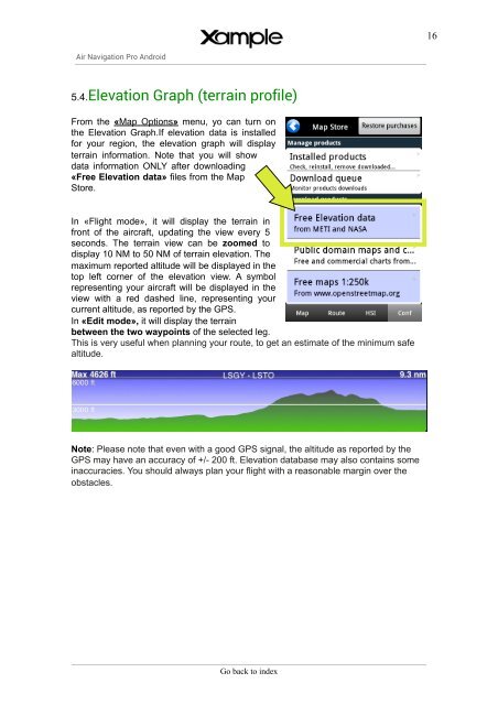
16<strong>Air</strong> <strong>Navigation</strong> <strong>Pro</strong> Android5.4.Elevation Graph (terrain profile)From the «Map Options» menu, yo can turn onthe Elevation Graph.If elevation data is installedfor your region, the elevation graph will displayterrain information. Note that you will showdata information ONLY after downloading«Free Elevation data» files from the MapStore.In «Flight mode», it will display the terrain infront of the aircraft, updating the view every 5seconds. The terrain view can be zoomed todisplay 10 NM to 50 NM of terrain elevation. Themaximum reported altitude will be displayed in thetop left corner of the elevation view. A symbolrepresenting your aircraft will be displayed in theview with a red dashed line, representing yourcurrent altitude, as reported by the GPS.In «Edit mode», it will display the terrainbetween the two waypoints of the selected leg.This is very useful when planning your route, to get an estimate of the minimum safealtitude.Note: Please note that even with a good GPS signal, the altitude as reported by theGPS may have an accuracy of +/- 200 ft. Elevation database may also contains someinaccuracies. You should always plan your flight with a reasonable margin over theobstacles.Go back to index