MISR: In-Flight Radiometric Calibration and Characterization Plan
MISR: In-Flight Radiometric Calibration and Characterization Plan
MISR: In-Flight Radiometric Calibration and Characterization Plan

Create successful ePaper yourself
Turn your PDF publications into a flip-book with our unique Google optimized e-Paper software.
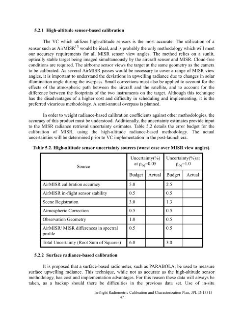
5.2.1 High-altitude sensor-based calibrationThe VC which utilizes high-altitude sensors is the most accurate. The utilization of asensor such as Air<strong>MISR</strong> 13 would be ideal, <strong>and</strong> is probably the only methodology which will meetour accuracy requirements for all <strong>MISR</strong> sensor view angles. The method relies on a sunlit,optically stable target being imaged simultaneously by the aircraft sensor <strong>and</strong> <strong>MISR</strong>. Cloud-freeconditions are required. The airborne sensor views the target at the same geometry as the camerato be calibrated. As several Air<strong>MISR</strong> passes would be necessary to cover a range of <strong>MISR</strong> viewangles, it is important to underst<strong>and</strong> the deviations in upwelling radiance due to changes in solarillumination angle during the overpass. Small corrections must also be applied to account for theeffects of the atmospheric path between the aircraft <strong>and</strong> the satellite, <strong>and</strong> to account for thedifference between the footprints of the two instruments on the target. Although this techniquehas the disadvantages of a higher cost <strong>and</strong> difficulty in scheduling <strong>and</strong> implementing, it is thepreferred vicarious methodology. A semi-annual overpass is planned.<strong>In</strong> order to weight radiance-based calibration coefficients against other methodologies, theaccuracy of this product must be understood. Additionally, the uncertainty estimates provide inputto the <strong>MISR</strong> radiance retrieval uncertainty estimates. Table 5.2 details the error budget for thecalibration of <strong>MISR</strong>, using the high-altitude radiance-based methodology. The actualuncertainties will be determined prior to VC implementation in the post-launch era.Table 5.2. High-altitude sensor uncertainty sources (worst case over <strong>MISR</strong> view angles).SourceUncertainty(%)at ρ eq =0.05Uncertainty(%) atρ eq =1.0Budget Actual Budget ActualAir<strong>MISR</strong> calibration accuracy 5.0 2.5Air<strong>MISR</strong> in-flight sensor stability 0.5 0.5Scene Registration 3.0 1.3Atmospheric Correction 0.5 0.5Observation Geometry 1.0 0.5Air<strong>MISR</strong>/ <strong>MISR</strong> differences in spectralprofile0.5 0.5Total Uncertainty (Root Sum of Squares) 6.0 3.05.2.2 Surface radiance-based calibrationIt is proposed that a surface-based radiometer, such as PARABOLA, be used to measuresurface upwelling radiance. This technique, while not as accurate as the high-altitude sensormethodology, has cost <strong>and</strong> implementation advantages. For this reason these data will always betaken, as a backup should there be difficulties in the previous data set. Use of in-situ<strong>In</strong>-flight <strong>Radiometric</strong> <strong>Calibration</strong> <strong>and</strong> <strong>Characterization</strong> <strong>Plan</strong>, JPL D-1331547