Americas ok.indd - World Water Council
Americas ok.indd - World Water Council
Americas ok.indd - World Water Council

You also want an ePaper? Increase the reach of your titles
YUMPU automatically turns print PDFs into web optimized ePapers that Google loves.
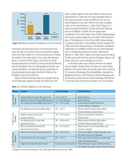
Figure 3.6 Mean Annual Precipitation in the <strong>Americas</strong>rainforests and also large tracts of arid and semi-aridareas are also to be found, with annual rainfall rangingfrom more than 6,000 mm in Central America to virtuallyno rainfall in the driest place in the world, the AtacamaDesert in northern Chile. Figure 3.6 shows the meanannual precipitation for North, Central and South America,and the Caribbean. Due to its geographical position andclimatic variability, the <strong>Americas</strong> are also vulnerable tonatural disasters, particularly the Gulf of Mexico, theCaribbean, and Central America.<strong>Water</strong>. Climatic diversity leads to an equally diverseset of hydrologic regimes. Overall, The <strong>Americas</strong> is thewater-richest region of the world. With a mean annualprecipitation of 1,084 mm, the total renewable water inthe region amounts to nearly 24,000 km 3 per annum,which represent more than 55% of the total renewablewater of the world (Annex 3, Table A3.2). Figure 3.7shows the values for North, Central and South America,and the Caribbean. In 2004, the per capita wateravailability of the whole region was 27,942 m 3 /person/year,but country values ranged from less than 100 m 3 /person/year in The Bahamas to more than 3,000 m 3 /person/yearin Jamaica and Cuba in the Caribbean. Values ranged from3,785 and 4,405 m 3 /person/year in El Salvador and Mexicorespectively, to 109,886, 275,415 and 312,154 m 3 /person/year in Canada, Guyana and Suriname, respectively.(Annex 3, Table A3.2, Figure 3.8 shows values for North,Central and South America, and the Caribbean; Figure 3.9shows values for some individual countries).In the Great Lakes area of North America the regionhas the largest concentration of inland non-saline waterbodies in the world. There are several large rivers includingSt. Lawrence, Mississippi, Rio Grande/Bravo, Usumacinta,Magdalena, Orinoco, São Francisco, Paraná, Paraguay, andthe Amazon, whose annual volume discharge of 6,700 km 3is five times that of the second largest river in the world,194th <strong>World</strong> <strong>Water</strong> ForumTable 3.1 Climatic Regimes in the <strong>Americas</strong>Group Climate 1 Latitude Range Global PositionIII. High-Altitude II. Mid-Latitude I. Low-AltitudeClimates Climates ClimatesTropical Moist Climates (Af) rainforest 10° S to 25° N Amazon Basin.Wet-Dry Tropical Climates (AW) savanna 15° to 25° N and S South America.Dry Tropical Climates (BW) desert blome 15° – 25° N and S Southwestern United States andnorthern Mexico; ArgentinaDry Mediatitude Climates (BS) steppe 35° – 55° N Western North America (Great Basin,Columbia Plateau, Great Plains).Mediterranean Climate (Cs) 30° – 50° N and S Central and southern California;chaparral blomeChilean coastDry Mediatitude Climates (Bs) 30° – 55 N and S Western North America (Great Basingrassiands blomeColumbia Plateau, Great Plains).Moist Continental Climate (Cf) 30° – 55° N and S Eastern parts of the United States andDecidous Forest blomeSouthern CanadaBoreal forest Climate (Dfc) taiga blome 50° – 70° N and S Central and Western Alaska; Canada, fromthe Yukon territory to Labrador.Tundra Climate (E) tundra blome 60° – 75° N Artic zone of North America; Hudson Bayregion; Greenland coast.Highland Climate (H) Alpine blome Found all over the world Rocky Mountain range in North America,the Andean mountain range in South America1Koeppen's Cliamte Classification. FAO_SDN_Agrometeorology Group. 1997.