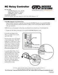
Chain Link Fence Wind Load Guide for the ... - Hoover Fence
Chain Link Fence Wind Load Guide for the ... - Hoover Fence
Chain Link Fence Wind Load Guide for the ... - Hoover Fence

You also want an ePaper? Increase the reach of your titles
YUMPU automatically turns print PDFs into web optimized ePapers that Google loves.
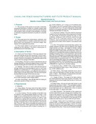
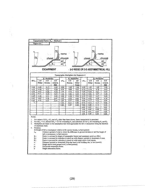
Topogrll})bie Factor, K'; - Method 2Figure 6-4 \I'I%1----- .!Jt.VSp,ed-op~ .r(upwind)..,/j :r(D"""wintl);, 1mIJ) ) ~ '-1mt"'!~s>!'i,~s;;;;,f:!f' .,~ESCARPMENT . 2·0 RIDGE OR3·D AXISYMMETRICAL HILLTopographic Multipliers <strong>for</strong> Exposure CK, Multiplier K z Multiplier K, MultiplierHlL b 2-D 2-D 3-D xlLi, 2-D All zlL b 2-D 2-D 3-DRidge Escarp. Axisym. Escarp. O<strong>the</strong>r Ridge Escarp_ Axisym.Hill Cases Hill0.20 .0.29 0_17 0.21' 0.00 1.00 1.00 0.00 1.00 1.00 1.000.25 0.36 0.21 0.26 0.50 0.&8 0.67 0:10 0.74 0.78 0.670.30 0.43 0_26 0.32 1.00 0.75 0.33 0.20 0.55 0.61 0.450.35 '0.51 0.30 0.37 1.50 0.63 0.00 0.30 0.41 0.47 0.300040" 0.58 0:34 0042 2.00 0.50 0.00 0.40 0.30 0.37 0.200.45 0.65 0.3& 0.47 2.50 0.3& 0.00 0.50 0.22 0.29 0.140.50 0.72 0.43 0.53 3.00 0.25 . 0.00 0.60 0.17 0.22 0.09....... 3.50 .0.13 0.00 0.70 0.12 0.17 0.064:00 0.00 0.00 0.80 0.09 0.14 0.040.90 0.07 0.11 0.03..1.00 0.05 0.08 0.021.50 om 0.02 0.002.00 .0.00 0.00 0.00Notes:I. For values ofBJL b • xILo and z/L b o<strong>the</strong>r than those shown, linear interpolation is pennitted.2. For HiL b > 0.5, assume H/L h == 0.5 '<strong>for</strong> evaluating K, and substitute 2H <strong>for</strong> L h <strong>for</strong> evaluating K z and K).3. Multipliers are based on <strong>the</strong> assumption that wind approaches <strong>the</strong> hill or escarpment along <strong>the</strong> directionof maximum slope.4. Notation:H:Height ofhill or escarpment relative to <strong>the</strong> upwind terrain, in feet (meters).L b : Distance upwind of crest to where <strong>the</strong> difference in ground elevation is half<strong>the</strong> height ofhill or escarpment, in feet (meters).K,: Factor to accOimt <strong>for</strong> shape oftopographic feature and maximum speed-up effect.K 2 : Factor to account <strong>for</strong> reduction in speed-up with distance upwind or downwind of crest.K J : Factor to aecount <strong>for</strong> reduction in speed-up with height above local terrain.x:. Distance (upwind or downwind) from <strong>the</strong> crest to <strong>the</strong> building site, in feet (meteTs).z: He!ght above local ground level, in feet (meters).11: Horizontal attenuation factor.y. Height attenuation factor.(29)