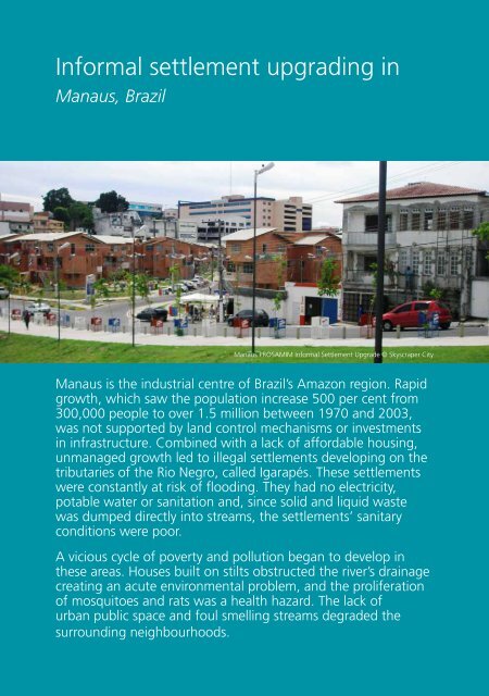
<strong>Urban</strong> planning <strong>for</strong> city leadersIn<strong>for</strong>mal settlement upgrading inManaus, BrazilManaus PROSAMIM In<strong>for</strong>mal Settlement Upgrade © Skyscraper <strong>City</strong>Manaus is the industrial centre of Brazil’s Amazon region. Rapidgrowth, which saw the population increase 500 per cent from300,000 people to over 1.5 million between 1970 and 2003,was not supported by land control mechanisms or investmentsin infrastructure. Combined with a lack of af<strong>for</strong>dable housing,unmanaged growth led to illegal settlements developing on thetributaries of the Rio Negro, called Igarapés. These settlementswere constantly at risk of flooding. They had no electricity,potable water or sanitation and, since solid and liquid wastewas dumped directly into streams, the settlements’ sanitaryconditions were poor.A vicious cycle of poverty and pollution began to develop inthese areas. Houses built on stilts obstructed the river’s drainagecreating an acute environmental problem, and the proliferationof mosquitoes and rats was a health hazard. The lack ofurban public space and foul smelling streams degraded thesurrounding neighbourhoods.102
How to address in<strong>for</strong>malitySolutionIn 2003, the Government of Amazonas initiated a three-phase upgrading programme, knownas Iguarape Manaus Social and Environmental Programme (PROSAMIM), which was coordinatedwith the municipal government and had support from the Inter-American Development Bank. Theintegrated approach to upgrading was highlighted by Governor Omar Aziz, who stressed: “Thework of upgrading is not just physical – it’s also about providing opportunities.” The programme<strong>for</strong>esaw the establishment of a road grid to connect the area with the city, the rehabilitation of thebridge, the creation of public spaces on the waterfront of the recuperated areas, and the provisionof sewer and storm water drainage systems. New housing units were built <strong>for</strong> the people that hadto be relocated. The capacity of municipal and state agencies responsible <strong>for</strong> urban planning wasdeveloped. This facilitated links with the Integrated Local Development Plan and a recently prepared<strong>Urban</strong> and Environment Master Plan to increase the supply of af<strong>for</strong>dable land.The first stage was started in 2003 and was ready <strong>for</strong> execution in three years. Areas of interventionwere prioritized based on a socio-environmental cost-benefit analysis which took into accountpopulation density and the severity of social and environmental problems. The Igarapé Educandos,a priority area, had a density of 115 p/ha and a population of 31,973 people living under the floodline which was 30 metres above sea level. Housing units were designed using locally availablematerials and followed area specifications in the Master Plan, which specified a minimum of 54 m 2<strong>for</strong> a two-bedroom unit. The scheme included commercial space, which was offered to residentswho had previously owned a shop in the in<strong>for</strong>mal settlement. New housing units’ owners were notallowed to make alterations or additions to the dwellings to prevent in<strong>for</strong>mal occupation of publicareas. New streets were designed to improve accessibility to the area and to connect it to the city’seconomic opportunities. In addition to improving the conditions in the area and to add value to thehousing units, parks on the banks of the Igarapés helped to prevent re-occupation and facilitatemaintenance of hydraulic structures. The infrastructure included water and sanitation services and asewerage system with collectors, interceptors and pumping stations.The designation of Special Areas of Social Interest aimed to increase the supply of af<strong>for</strong>dable land<strong>for</strong> residential schemes, allowing low-income families access to properly urbanized areas. Closecollaboration with the community was facilitated by the creation of 32 associations to conveyresidents’ interests and concerns. Involving households in decisions concerning resettlement optionsgreatly empowered the community.ResultsIn its first two phases, an investment of USD 400 million was mobilized. By February 2012, theprogramme had benefited over 60,000 people in Manaus through the construction of over 7 km ofroads and bridges that have improved citywide traffic flow; and 130 km of sewerage pipes that haveprevented the direct dumping on Igarapés of about 3 million litres of liquid waste and 3,000 kg ofhousehold waste per day. Over 2,000 housing units connected to water, sanitation and electricitynetworks had been built.The seven parks built, with a total area of 218,802 m 2 , have contributed to developing civic prideand optimism. The Park Senator, Jefferson Peres, is now one of the city’s most valued assets. Theintegrated intervention has helped to reduce crime by more than 50 per cent.The third phase is expected to further improve the access to surrounding neighbourhoods with newroads and bicycle paths. In addition, five parks, social facilities and a 50 km sewer network will bebuilt.103