§¨¦80 §¨¦90 §¨¦70 §¨¦29 §¨¦76 §¨¦24 §¨¦81 §¨¦37 §¨¦29 §¨¦90
§¨¦80 §¨¦90 §¨¦70 §¨¦29 §¨¦76 §¨¦24 §¨¦81 §¨¦37 §¨¦29 §¨¦90
§¨¦80 §¨¦90 §¨¦70 §¨¦29 §¨¦76 §¨¦24 §¨¦81 §¨¦37 §¨¦29 §¨¦90

Create successful ePaper yourself
Turn your PDF publications into a flip-book with our unique Google optimized e-Paper software.
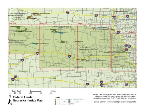
§¨¦ 70 Pipestone National MonumentMount Rushmore National Memorial Minuteman Missile National Historic Site§¨¦ 90Jewel Cave National MonumentWind Cave National Park§¨¦ 37Badlands National Park§¨¦ 84aSouth DakotaDetail 1 Detail 2Detail 2Oglala National GrasslandFort Niobrara National Wildlife RefugeNiobrara National Scenic RiverLewis And Clark LakeSoldier Creek WildernessSamuel R. McKelvie National ForestMissouri National Recreational RiverMissouri National Recreation RiverPine Ridge National Recreation AreaMerritt ReservoirValentine National Wildlife RefugeAgate Fossil Beds National Monument§¨¦ 29Minnesota§¨¦ 29 §¨¦ 90Detail 4IowaNorth Platte National Wildlife RefugeScotts Bluff National MonumentChimney Rock National Historical ParkCrescent Lake National Wildlife Refuge§¨¦ 102Nebraska National ForestCalamus ReservoirPrototype Low Frequency Communications SystemDavis Creek Reservoir§¨¦ 680Sherman ReservoirArmy Training Area§¨¦ 61bMead Army National Guard FacilityArmy Reserve Outdoor Training AreaCornhusker Army Ammunition Plant§¨¦ 80ColoradoBl§¨¦70§¨¦ 24Offutt Air Force Base§¨¦ 76 Kearney Rifle RangeRoman L. Hruska U.S. Animal Meat Research CenterEnders ReservoirHarry Strunk LakeHugh Butler LakeHomestead National Monument MissouriSwanson LakeHarlan County LakeKansasNicodemus National Historic SiteBrown v. Board of Education National Historic Site§¨¦§¨¦ §¨¦ 335Miles0 25 50 100 150 200±Federal LandsNebraska - Index MapLegendBureau of ReclamationDepartment of DefenseU.S. Forest ServiceU.S. Fish & Wildlife ServiceNational Park ServiceOTHERFederal Land Management Area (FLMA) geographic area issubject to change. For most current unit level information,contact the appropriate FLMA. FLMA data may be missing.Source: Central Federal Lands Highway Division | 02/2013
NiobraraSouth DakotaFall RiverOglala National GrasslandShannonBennettSoldier Creek WildernessDawesNebraska National ForestPine Ridge National Recreation AreaCherrySiouxAgate Fossil Beds National MonumentBox Butte ReservoirSheridanWyomingBox ButteGoshenNebraskaNorth Platte National Wildlife RefugeScotts BluffScotts Bluff National MonumentScotts Bluff National MonumentGrantChimney Rock National Historical ParkMorrillCrescent Lake National Wildlife RefugeBannerGardenArthurLaramieKimballCheyenne§¨¦ 80 §¨¦ 76 §¨¦ 102KeithDeuelColoradoWeldLoganLegendSedgwickBureau of ReclamationDepartment of DefensePerkinsU.S. Fish & Wildlife ServiceNational Park ServiceMiles0 5 10 20 30 40U.S. Forest ServicePhillipsOTHERCounty BoundariesChase±Federal LandsNebraska - Detail 1Federal Land Management Area (FLMA) geographic area issubject to change. For most current unit level information,contact the appropriate FLMA. FLMA data may be missing.Source: Central Federal Lands Highway Division | 02/2013
ShannonSheridanBennettSouth DakotaSamuel R. McKelvie National ForestCherryMerritt ReservoirToddFort Niobrara WildernessFort Niobrara National Wildlife RefugeNiobrara National Scenic RiverValentine National Wildlife RefugeTrippBrownKeya PahaGregoryRockGrantHookerThomasBlaineLoupNebraska National ForestGardenNebraskaArthurMcPhersonLoganCusterKeithDeuel§¨¦ 80LincolnSedgwickPerkinsDawsonPhillipsChaseHayesFrontierGosperPhelpsColoradoEnders ReservoirHugh Butler LakeHarry Strunk LakeDundyHitchcockYumaSwanson LakeKansas CheyenneRawlins Miles0 10 20 40 60 80Red WillowDecaturLegendFurnasHarlanBureau of Reclamation U.S. Fish & Wildlife ServiceDepartment of Defense National Park ServiceU.S. Forest Service OTHERCounty BoundariesNortonPhillips±Federal LandsNebraska - Detail 2Federal Land Management Area (FLMA) geographic area issubject to change. For most current unit level information,contact the appropriate FLMA. FLMA data may be missing.Source: Central Federal Lands Highway Division | 02/2013
Keya PahaNiobrara National Scenic RiverRockGregoryBoydHoltCharles MixSouth DakotaBon HommeLewis And Clark LakeMissouri National Recreation RiverMissouri National Recreational RiverKnoxYanktonCedarTurnerClayLincolnDixonUnionAntelopePierceWayneThurstonLoupCalamus ReservoirGarfieldWheelerMadisonStantonCumingBooneCusterNebraskaValleyDavis Creek ReservoirGreeleyNancePlatteColfaxDodgeSherman ReservoirArmy Training AreaShermanHowardMerrickPolkButlerSaundersDawsonBuffaloCornhusker Army Ammunition PlantHamiltonHall§¨¦ 80YorkSewardLancasterKearney Rifle RangePhelpsKearneyRoman L. Hruska U.S. Animal Meat Research CenterAdamsClayFillmoreSalineHarlanFranklinWebsterNuckollsHarlan County LakeKansasPhillipsSmithJewell Miles0 10 20 40 60 80LegendThayerBureau of ReclamationDepartment of DefenseU.S. Forest ServiceRepublicHomestead National MonumentGageJeffersonU.S. Fish & Wildlife ServiceNational Park ServiceOTHERCounty BoundariesWashington Marshall±Federal LandsNebraska - Detail 3Federal Land Management Area (FLMA) geographic area issubject to change. For most current unit level information,contact the appropriate FLMA. FLMA data may be missing.Source: Central Federal Lands Highway Division | 02/2013
Bon Homme YanktonLewis And Clark LakeKnoxMissouri National Recreational River UnionMissouri National Recreation RiverCedarSouth DakotaClayDixonDakotaSiouxPlymouthWoodburyO'BrienCherokeeIdaClayBuena VistaSacCumingMononaCrawfordBurtPlatteNancePolkYorkButlerSeward§¨¦ 29 §¨¦ 680 §¨¦ 80PierceWayneThurstonMadisonStantonIowaCarrollMerrickNebraskaColfaxDodgeWashington §¨¦§¨¦ 29§¨¦ 3a DouglasSaunders§¨¦ §¨¦ 1aMead Army National Guard FacilityArmy Reserve Outdoor Training AreaSarpyOffutt Air ForceCass§¨¦ 80 §¨¦ 680Base§¨¦ 27MillsLancasterPottawattamieFremontPageCassMontgomeryHarrisonShelbyAudubonOtoeFillmoreSalineJohnsonHomestead National MonumentGageThayerJeffersonPawneeRepublicWashingtonMarshallKansas Miles0 10 20 40 60 80AtchisonNemahaNodawayMissouriRichardsonHoltLegendAndrewBureau of Reclamation U.S. Fish & Wildlife ServiceDepartment of Defense National Park ServiceNemaha U.S. Forest Service Brown OTHERCounty Boundaries DoniphanBuchanan±Federal LandsNebraska - Detail 4Federal Land Management Area (FLMA) geographic area issubject to change. For most current unit level information,contact the appropriate FLMA. FLMA data may be missing.Source: Central Federal Lands Highway Division | 02/2013