WEST COAST OF ISTRIAPIRANSKI ZALJEV, bayCharts: 100-15; MK-1; Plan 11Piranski Zaljev is a part of the Gulf of Trieste entered between RtMadona and Rt Savudrija (Gornja Savudrija). Its north coast isheavily populated so that the small town of Piran together withPortoroæ and marinas Bernardin and Portoroæ, and numerous hotelsettlements seem to be connected in a unity. Cultivated hills coveredwith olive and cypress trees descend steeply to the sea wheredepths along shore are small. On the low east coast of the bay therivers Lera and Dragonja flow into the sea.Maritime border between Croatia and Slovenia passes throughPiranski Zaljev.ANCHORAGE: In a Bora, E and SE winds the best anchoragefor larger vessels is situated about 500 m offshore, W of RtBernardin; good holding. During winds from III quadrantanchorage may be obtained about 800 m off the SW coast ofthe bay; good holding.LANDMARKS: Lighthouse on Rt Madona - grey octagonaltower; town of Piran, hotel settlement on Rt Bernardin andlighthouse on Rt Savudrija - stone tower (29 m) with galleryand grey cupola.WEATHER:The bay affords the best shelter from the Bora in theGulf of Trieste, especially its N part.The Scirocco is seldom violentand raises no sea, owing to the orientation of the bay.Thebay is exposed to W and NW winds which can raise seas. Innerpart of the Portoroæ boat harbour is sheltered from all winds.FOG: Normally occurs in the winter period.CURRENTS:Tidal currents are predominant, attaining rates ofup to 0.4 kn. Strong and persistent NW and W winds mayincrease the current rate to 0.8 kn.<strong>SEA</strong> LEVEL: Mean tidal amplitudes range from 0.6 to 0.9 m.Persistent gale winds may cause a rise in the sea level of about1.2 m (cyclonic Scirocco) or a fall of about 0.5 m anticyclonicBora).SHELTERS: On NE coast: harbours Piran and Portoroæ andmarinas Bernardin and Portoroæ.On SW coast: hotel settlement Kanegra situated about 3.3miles E of Savudrija lighthouse; depths along the "T" shapedpier are about 3 m.CABLES AND PIPELINES: Sewer is laid for 3450 m from apoint about 0.4 miles NW of Rt Bernardin in bearing 300º.REGULATIONS:Anchoring is prohibited in front of Piran harbour,between Rt Madona and the light on head of W molewithin 300 m of the coast, and from the line connecting RtBernardin - Rt Sv. Petar toward the head of the bay.Anchoring,fishing, all underwater activities and navigation by power-drivenvessels are prohibited in the area of nature reserve "RtMadona" within three yellow buoys on the following positions:a) 45° 31.96’ N - 013° 24.11’ Eb) 45° 31.81’ N - 013° 33.89’ Ec) 45° 31.70’ N - 013° 34.15’ EAnchoring and fishing are prohibited in 300 m radius aroundthe sewer.CAUTION: Care is necessary in avoiding marine farmsin the bay.Savudrija, lighthouse (from S)RT SAVUDRIJA is the NW extremity of the Istrian peninsula.TheNW side of the peninsula of Savudrija gently slopesdown to the rugged coast, ending in three points - GornjaSavudrija, Srednja Savudrija and Donja Savudrija. Villages arevisible on the nearby cultivated hills. On the point DonjaSavudrija stands the lighthouse Savudrija - stone tower withgallery and grey cupola, fitted with fog siren (42 s 2 M).Stara Savudrija is a boat harbour about 0.8 mile NE of thelighthouse Savudrija, between the points Gornja Savudrija andDonja Savudrija. It is sheltered by a breakwater, 177 m inlength, fitted with light on its head - white conical tower withred post and lamp. Electricity and water are available from nearthe breakwater root.The harbour provides shelter to smallercraft from the Bora and NW winds. Care is necessary in avoidinga shoal about 20 m E of the breakwater head, marked byseveral metal poles.REGULATIONS: From Rt Savudrija to the anchorage of Koperharbour, navigation is prohibited to vessels with draught over15 m within 2 miles of the coast and at a speed over 12 kn,because of small depths and heavy traffic.CAUTION: Care is necessary to avoid several shoalsextending to about 1.2 mile from the cape.64
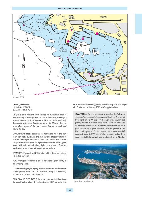
WEST COAST OF ISTRIARevision 2001UMAG, harbour(45° 26.2’ N - 13° 31.0’ E)Charts: 100-15; MK-1; Plan 11Umag is a small medieval town situated on a peninsula about 4miles south of Rt Savudrija, with remains of town walls, towers, picturesquesquares and old houses in Venetian Gothic and earlyRenaissance styles, as well as churches from the 15th to 18th centuries.Modern part of the town extends beyond the walls andaround the bay.LANDMARKS: Hotel complex on Rt Paklena N of the harbour;high hotel building in the harbour and a factory chimneyS of the town; light on Paklena shoal - red tower with columnand gallery on base in the sea; light on breakwater head - greentower with column and gallery; light on the head of marinabreakwater - red tower with column and gallery.on S breakwater in Umag harbour) in bearing 260º in a lengthof 1.3 mile and in bearing 250º to Chioggia harbour.CAUTION: Care is necessary in avoiding the followingdangers: Paklena shoal when approaching from N, markedby a light on its W side - red tower with column andgallery on base in the sea; rocky shoal Garofulin on N sideof harbour entrance, W of marina breakwater, on its Spart marked by a pillar beacon coloured yellow aboveblack and topmark - 2 black cones points downward (Scardinal); shoal in SW part of the harbour, marked by agreen conical light buoy (lateral starboard) on its N edge.WEATHER: Exposed to NNW wind which does not raise asea in the harbour.FOG:Average occurrence is on 15 occasions a year, chiefly inthe winter period.CURRENTS: Ingoing/outgoing tidal currents are predominant,attaining rates of up to 0.3 kn. Persistent strong NW wind mayincrease the current rate to 0.6 kn.CABLES AND PIPELINES: Submarine optic cable is laid fromthe cove Muglela (about 0.4 mile in bearing 121º from the lightUmag, harbour (from S)65