Maple Ridge Profile - City of Edmonton
Maple Ridge Profile - City of Edmonton
Maple Ridge Profile - City of Edmonton

You also want an ePaper? Increase the reach of your titles
YUMPU automatically turns print PDFs into web optimized ePapers that Google loves.
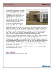
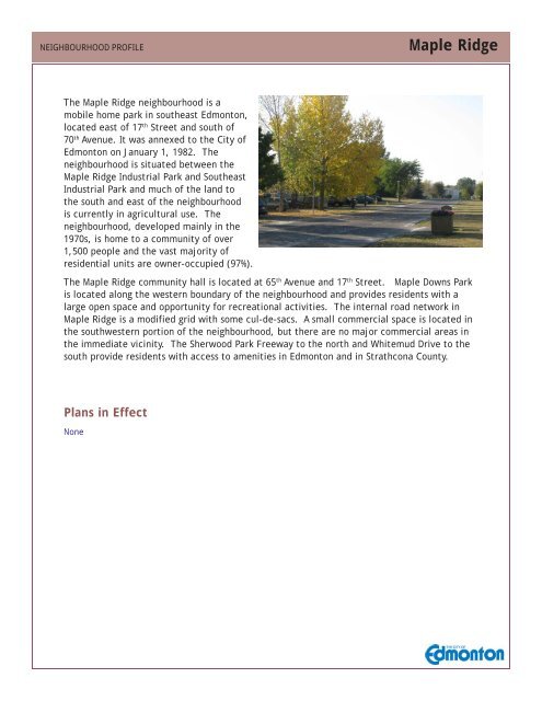
NEIGHBOURHOOD PROFILE<strong>Maple</strong> <strong>Ridge</strong>The <strong>Maple</strong> <strong>Ridge</strong> neighbourhood is amobile home park in southeast <strong>Edmonton</strong>,located east <strong>of</strong> 17 th Street and south <strong>of</strong>70 th Avenue. It was annexed to the <strong>City</strong> <strong>of</strong><strong>Edmonton</strong> on January 1, 1982. Theneighbourhood is situated between the<strong>Maple</strong> <strong>Ridge</strong> Industrial Park and SoutheastIndustrial Park and much <strong>of</strong> the land tothe south and east <strong>of</strong> the neighbourhoodis currently in agricultural use. Theneighbourhood, developed mainly in the1970s, is home to a community <strong>of</strong> over1,500 people and the vast majority <strong>of</strong>residential units are owner-occupied (97%).The <strong>Maple</strong> <strong>Ridge</strong> community hall is located at 65 th Avenue and 17 th Street. <strong>Maple</strong> Downs Parkis located along the western boundary <strong>of</strong> the neighbourhood and provides residents with alarge open space and opportunity for recreational activities. The internal road network in<strong>Maple</strong> <strong>Ridge</strong> is a modified grid with some cul-de-sacs. A small commercial space is located inthe southwestern portion <strong>of</strong> the neighbourhood, but there are no major commercial areas inthe immediate vicinity. The Sherwood Park Freeway to the north and Whitemud Drive to thesouth provide residents with access to amenities in <strong>Edmonton</strong> and in Strathcona County.Plans in EffectNone
NEIGHBOURHOOD PROFILE<strong>Maple</strong> <strong>Ridge</strong>Period <strong>of</strong> ConstructionOccupied Units % <strong>of</strong> Total <strong>City</strong>%Before 1946 - - 41946 to 1960 10 1 171961 to 1970 - 0 161971 to 1980 400 58 241981 to 1985 130 19 101986 to 1990 40 6 61991 to 1995 25 4 61996 to 2000 25 4 62001 to 2006 45 7 12Occupied Private Dwellings 685 100 100Source: 2006 Census <strong>of</strong> Canada, Statistics CanadaOccupied Private Dwellings by TenureTenure Number % <strong>of</strong> Total <strong>City</strong>%Owner Occupied 630 93 63Renter Occupied 50 7 37Total 680 100 100Source: 2006 Census <strong>of</strong> Canada, Statistics CanadaResidential Units by Unit TypeType <strong>of</strong> Unit Number % <strong>of</strong> Total <strong>City</strong>%Single-detached house 15 2 50Semi-detached, triplex, fourplex - - 7Row house - - 10Apartment over 5 storeys - - 9Apartment under 5 storeys - - 23Movable dwelling 670 98 1Total 685 100 100Source: 2006 Census <strong>of</strong> Canada, Statistics CanadaNote: totals may not sum due to random rounding
NEIGHBOURHOOD PROFILE<strong>Maple</strong> <strong>Ridge</strong>Population by Age and GenderMale Female Total Nbhd <strong>City</strong>2006% 2006%0 - 9 85 60 145 9 1110 - 19 135 105 240 16 1320 - 29 85 60 145 9 1830 - 39 120 100 220 14 1440 - 49 145 105 250 16 1650 - 59 85 125 210 14 1360 - 69 105 115 220 14 770+ 45 70 115 7 8Total 805 740 1,545 100 100Source: 2006 Census <strong>of</strong> Canada, Statistics CanadaHousehold by Household sizePpl per Household Households Nbhd <strong>City</strong> Nbhd2006% 2006% 1986%1 person 205 30 30 142 people 275 40 33 353 people 95 14 15 234-5 people 85 13 19 296 or more 20 3 3 1Total 680 100 100 100Source: 2006 Census <strong>of</strong> Canada, Statistics CanadaPopulation by Mobility Status (based on address five years previous)# <strong>of</strong> People % Total <strong>City</strong>%Non-Movers 615 42 50Moved from Elsewhere in <strong>Edmonton</strong> 650 44 32Moved from Elsewhere in Alberta 130 9 7Moved from Elsewhere in Canada 75 5 7Moved from outside Canada 10 1 5Source: 2006 Census <strong>of</strong> Canada, Statistics CanadaNote: totals may not sum due to random rounding
NEIGHBOURHOOD PROFILE<strong>Maple</strong> <strong>Ridge</strong>Family HouseholdsFamily Type Households % <strong>of</strong> Total <strong>City</strong>%Married couples 250Without children at home 150 33 29With children at home 100 22 40Common-law couples 120Without children at home 80 18 9With children at home 40 9 4Total lone-parent families 85Female parent 50 11 15Male parent 30 7 4Total 455 100 100Source: 2006 Census <strong>of</strong> Canada, Statistics CanadaHousehold Income 2005Income Households % <strong>of</strong> Total <strong>City</strong>%Household income in 2005 685Under $10,000 30 4 4$10,000 to $19,999 60 9 10$20,000 to $29,999 30 4 9$30,000 to $39,999 80 12 11$40,000 to $49,999 105 15 10$50,000 to $59,999 110 16 9$60,000 to $69,999 40 6 8$70,000 to $79,999 40 6 7$80,000 to $89,999 45 7 6$90,000 to $99,999 45 7 5$100,000 and over 90 13 21Median household income $ 50,941 57,085Average household income $ 58,829 72,950Source: 2006 Census <strong>of</strong> Canada, Statistics CanadaNote: totals may not sum due to random rounding
NEIGHBOURHOOD PROFILE<strong>Maple</strong> <strong>Ridge</strong>Population by Ethnic OriginPeople % <strong>of</strong> Total <strong>City</strong>%European origins 730 30 32British Isles origins 780 32 26Other North American origins (includes Canadian) 450 19 12East and Southeast Asian origins 10 0 8French origins 150 6 8Aboriginal origins 210 9 5South Asian origins 20 1 4African origins 20 1 2Arab origins 20 1 1Latin, Central and South American origins 10 0 1Caribbean origins 0 0 1West Asian origins 10 0 0Oceania origins 0 0 0Total 2,410 100 100The sum <strong>of</strong> the ethnic groups in this table is greater than the total population countbecause a person may report more than one ethnic origin in the census.Source: 2006 Census <strong>of</strong> Canada, Statistics CanadaJourney to Work (employed labour force)Transportation Method People % <strong>of</strong> Total <strong>City</strong>%Car, truck, van as driver 635 78 71Car, truck, van as passenger 80 10 8Public transit 50 6 13Walked 10 1 6Bicycle 10 1 1Motorcycle 10 1 -Taxicab - - -Other method 20 2 1Total 815 100 100Source: 2006 Census <strong>of</strong> Canada, Statistics CanadaNote: totals may not sum due to random rounding
122 ST75 ST50 ST17 STNEIGHBOURHOOD PROFILE<strong>Maple</strong> <strong>Ridge</strong>2008 Neighbourhood Photo and Current ZoningSoutheast Industrial<strong>Maple</strong> <strong>Ridge</strong> IndustrialSoutheast Industrial<strong>Maple</strong> <strong>Ridge</strong> Industrial97 ST167 AVE227 AVE34 STMERIDIAN STMANNING DRIVEZoning CategoriesRMH - mobile home zoneCNC - neighbourhood convenience commercialAP - public parks zonePU - public utility zone170 ST118 AVE137 AVEYELLOWHEAD TRAIL118 AVESTONY PLAIN ROAD142 STWHITEMUD DRIVE82 AVE199 STTERWILLEGAR DRIVECALGARY TRAILNo reproduction <strong>of</strong> this map, in whole or in part, is permitted without the express writtenconsent <strong>of</strong> the <strong>City</strong> <strong>of</strong> <strong>Edmonton</strong> Planning and Development Department.ELLERSLIE RD (9 AVE SW)The <strong>City</strong> <strong>of</strong> <strong>Edmonton</strong> disclaims any liability for the use <strong>of</strong> this map.