Deformations of a highway embankment on degraded permafrost
Deformations of a highway embankment on degraded permafrost
Deformations of a highway embankment on degraded permafrost

You also want an ePaper? Increase the reach of your titles
YUMPU automatically turns print PDFs into web optimized ePapers that Google loves.
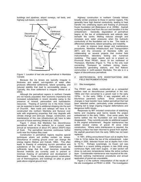
uildings and pipelines, airport runways, rail beds, and<str<strong>on</strong>g>highway</str<strong>on</strong>g> sub-bases, cuts and fills.Disc<strong>on</strong>tinuousPermafrostWinnipegPR391Thomps<strong>on</strong>ChurchillC<strong>on</strong>tinuous<strong>permafrost</strong>-1˚CFigure 1. Locati<strong>on</strong> <str<strong>on</strong>g>of</str<strong>on</strong>g> test site and <strong>permafrost</strong> in Manitoba,CanadaBecause the ice lenses are typically irregular inthickness and extent, out-migrati<strong>on</strong> <str<strong>on</strong>g>of</str<strong>on</strong>g> water <str<strong>on</strong>g>of</str<strong>on</strong>g>tenproduces differential settlements, lateral spreading, andreduced stability that lead to serviceability issues. .Typically, this thaw settlement is irregular (Hinkel et al.2003).Although the <strong>permafrost</strong> regi<strong>on</strong>s in northern Canadaare not heavily populated, their ec<strong>on</strong>omic importance hasincreased substantially in recent decades owing to thepresence <str<strong>on</strong>g>of</str<strong>on</strong>g> mineral, petrocarb<strong>on</strong> and hydroelectricresources. Thawing <str<strong>on</strong>g>of</str<strong>on</strong>g> summer ice in the Arctic Oceancan be expected to lead to additi<strong>on</strong>al shipping into the port<str<strong>on</strong>g>of</str<strong>on</strong>g> Churchill. New roads and railways will have to bec<strong>on</strong>structed into northern Manitoba and Nunavut oversoils with engineering properties that may degrade withclimate change and land-use. Design, c<strong>on</strong>structi<strong>on</strong>, andmaintenance <str<strong>on</strong>g>of</str<strong>on</strong>g> this new infrastructure will have to takeaccount <str<strong>on</strong>g>of</str<strong>on</strong>g> future warming (Hinkel et al. 2003).Figure 1 shows that Manitoba has disc<strong>on</strong>tinuous<strong>permafrost</strong> north <str<strong>on</strong>g>of</str<strong>on</strong>g> the isotherm for a current meanannual air temperature <str<strong>on</strong>g>of</str<strong>on</strong>g> about 0ºC (about 2500ºC-days<str<strong>on</strong>g>of</str<strong>on</strong>g> frost). The <strong>permafrost</strong> becomes c<strong>on</strong>tinuous furthernorth near the Huds<strong>on</strong> Bay coast.C<strong>on</strong>structi<strong>on</strong> in <strong>permafrost</strong> regi<strong>on</strong>s requires specialtechniques where soil pr<str<strong>on</strong>g>of</str<strong>on</strong>g>iles c<strong>on</strong>tain ice lenses.Disturbance <str<strong>on</strong>g>of</str<strong>on</strong>g> existing ground cover can change theenergy regime (Nels<strong>on</strong> and Outcalt, 1982). This <str<strong>on</strong>g>of</str<strong>on</strong>g>tenleads to thawing <str<strong>on</strong>g>of</str<strong>on</strong>g> underlying ice-rich <strong>permafrost</strong> andsubsidence <str<strong>on</strong>g>of</str<strong>on</strong>g> the road bed. <str<strong>on</strong>g>Deformati<strong>on</strong>s</str<strong>on</strong>g> can besufficiently large that the road becomes inoperable.Several methods are currently used to prevent orminimize thawing <str<strong>on</strong>g>of</str<strong>on</strong>g> <strong>permafrost</strong> and development <str<strong>on</strong>g>of</str<strong>on</strong>g>thermokarst. These include above-ground c<strong>on</strong>structi<strong>on</strong>,use <str<strong>on</strong>g>of</str<strong>on</strong>g> thermosyph<strong>on</strong>s, and buildings <strong>on</strong> piles or gravelpads above original ground level.Highway c<strong>on</strong>structi<strong>on</strong> in northern Canada followsbroadly similar practices to those in warmer regi<strong>on</strong>s. Fillsgenerally have high thermal c<strong>on</strong>ductivity, leading to heattransfer into underlying layers and thawing <str<strong>on</strong>g>of</str<strong>on</strong>g> previouslyfrozen foundati<strong>on</strong> soil (Batenipour et al. 2009b). Asphaltsurfacing absorbs heat from the sun and transfers it to the<str<strong>on</strong>g>embankment</str<strong>on</strong>g>. Generally, degradati<strong>on</strong> <str<strong>on</strong>g>of</str<strong>on</strong>g> <strong>permafrost</strong>begins at the toe <str<strong>on</strong>g>of</str<strong>on</strong>g> <str<strong>on</strong>g>embankment</str<strong>on</strong>g>s and extends laterbeneath the centre. Melting reduces strength andincreases pore water pressures when the hydraulicc<strong>on</strong>ductivity <str<strong>on</strong>g>of</str<strong>on</strong>g> the foundati<strong>on</strong> soil is low. This leads todifferential settlements, lateral spreading, and instability.In order to improve local design and maintenanceprocedures, Manitoba Infrastructure and Transportati<strong>on</strong>(MIT) and the University <str<strong>on</strong>g>of</str<strong>on</strong>g> Manitoba (UM) arecollaborating <strong>on</strong> several projects that involve fieldinstrumentati<strong>on</strong>, laboratory testing and numericalmodeling. This paper reports work <strong>on</strong> a project <strong>on</strong>Provincial Road PR391, about 18 km northwest <str<strong>on</strong>g>of</str<strong>on</strong>g>Thomps<strong>on</strong>, Manitoba (Figure 1). This is the <strong>on</strong>ly roadc<strong>on</strong>necting Thomps<strong>on</strong> to northern mining towns,hydroelectric generating stati<strong>on</strong>s, and first Nati<strong>on</strong>scommunities in north-western Manitoba. The site is in aregi<strong>on</strong> <str<strong>on</strong>g>of</str<strong>on</strong>g> disc<strong>on</strong>tinuous <strong>permafrost</strong>.2 GEOTECHNICAL SITE INVESTIGATIONS ANDFIELD INSTRUMENTATIONS2.1 Site Investigati<strong>on</strong>The PR391 was initially c<strong>on</strong>structed as a compactedearthen road <strong>on</strong> disc<strong>on</strong>tinuous <strong>permafrost</strong> in the mid-1960s and then c<strong>on</strong>verted to a gravel road in the early1970s. In the early 1980s, it was upgraded with abituminous pavement surface. Since c<strong>on</strong>structi<strong>on</strong>,changes in heat transfer have melted <strong>permafrost</strong> that hadbeen detected earlier, particularly under <str<strong>on</strong>g>embankment</str<strong>on</strong>g>s.Thawing led to large <strong>on</strong>going irregular deformati<strong>on</strong>s anddangerous traffic issues.Resp<strong>on</strong>ses by MIT included c<strong>on</strong>structi<strong>on</strong> <str<strong>on</strong>g>of</str<strong>on</strong>g> stabilizingberms and insulating peat berms beside the project<str<strong>on</strong>g>embankment</str<strong>on</strong>g> in the early 1990s. Over some years, theberms settled into the foundati<strong>on</strong> soil and essentiallydisappeared. They currently provide no additi<strong>on</strong>al supportto the original <str<strong>on</strong>g>embankment</str<strong>on</strong>g>. Regular maintenance hasadded several metres <str<strong>on</strong>g>of</str<strong>on</strong>g> gravel fill since initialc<strong>on</strong>structi<strong>on</strong>. Where extra maintenance is required, thewearing surface has been returned to gravel from asphalt:the asphalt pavement from the early 1980s has not beenreplaced.In 1991, drilling encountered frozen soil at depths from1.9m to 10.5m below the toe <str<strong>on</strong>g>of</str<strong>on</strong>g> the <str<strong>on</strong>g>embankment</str<strong>on</strong>g>. Laterdrilling in 2005, detected frozen soil at depths from 4.6mto 10.7m. Perhaps surprisingly, no frozen soil wasidentified in a recent drilling program in late 2008 usingc<strong>on</strong>tinuous flight, solid stem augers. A later secti<strong>on</strong> willshow no sub-zero temperatures below the active surfacelayer. C<strong>on</strong>siderable maintenance was required at the site.Records outlining maintenance procedures and annualapplicati<strong>on</strong> <str<strong>on</strong>g>of</str<strong>on</strong>g> gravel are unavailable.Figure 2 is the authors’ interpretati<strong>on</strong> <str<strong>on</strong>g>of</str<strong>on</strong>g> the results <str<strong>on</strong>g>of</str<strong>on</strong>g>the site investigati<strong>on</strong> at PR391 in 2008. The investigati<strong>on</strong>