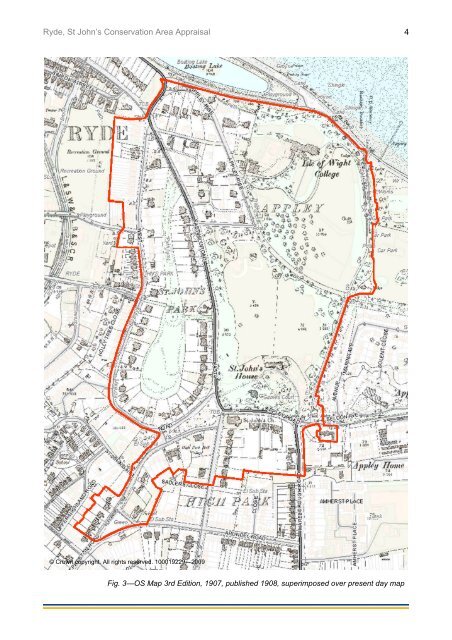
<strong>Ryde</strong>, <strong>St</strong> John’s <strong>Conservation</strong> <strong>Area</strong> Appraisal 3the surrounding land. The original house andpart <strong>of</strong> the original estate now form BishopLovett Middle School. By comparing thehistoric maps it can be seen that, although thebuildings have been added to, the boundaries<strong>of</strong> these two historic estates are more or lessunchanged.4.3 The 1860s map (Fig. 2, page 2) showsthe Church <strong>of</strong> <strong>St</strong> John the Baptist (built in1843, formed into an ecclesiastical parish in1844) and the residential development <strong>of</strong> <strong>St</strong>John’s Park (built in the 1850s): both were builton land that was formerly part <strong>of</strong> the extended<strong>St</strong> John’s estate. With regard to <strong>St</strong> John’sPark, the map on page 4 (the 1908 OS Mapsuperimposed over a present-day map, Fig. 3),shows that, in the intervening years, eventhough some <strong>of</strong> these houses have beenreplaced or added to, the outline <strong>of</strong> thedevelopment, with its inner parkland, is alsoessentially unchanged.5 Archaeological potential5.1 Evidence in the area shows continuity<strong>of</strong> settlement from the Neolithic periodonwards. Archaeological finds listed on thehistoric environment record (HER) include ahoard <strong>of</strong> 12 Bronze Age palstaves (a type <strong>of</strong>axe) found at <strong>St</strong> Johns Park, sherds <strong>of</strong> Romanor Iron Age pottery and evidence <strong>of</strong> a possibleRoman cemetery in the vicinity. Anexamination <strong>of</strong> the unpublished OS Map <strong>of</strong>1793 (Fig. 1, page 2) shows a dispersedsettlement pattern but little evidence <strong>of</strong> amedieval field system: rather the field patternappears to derive from 16 th to 18 th centuryenclosure. Further information on the area canbe obtained from the historic landscapecharacterisation (HLC) maps and descriptions.5.2 This document does not identify all theknown heritage assets within the conservationarea, therefore any omission <strong>of</strong> any building,feature or space should not be taken to implythat it is <strong>of</strong> no interest.SPATIAL ANALYSIS6 Character areas6.1 The <strong>Ryde</strong>, <strong>St</strong> John’s <strong>Conservation</strong> <strong>Area</strong>covers an area that contains previousdesigned landscapes and planned settlement.The road layout, the building density, thearchitectural details and the presence <strong>of</strong> openspaces are all characteristics derived from thearea’s historic development: this, in part, hasbeen determined by the topography andgeography <strong>of</strong> the area but the majordetermining factor is previous land ownershipand usage.6.2 Based on this spatial analysis it is alsopossible to discern 3 distinct character areaswithin the conservation area (Fig. 4, page 5).There is clear delineation (almost east fromwest) along the A3055 (East Hill Road): thisseparates <strong>St</strong> John’s Park and the Church <strong>of</strong> <strong>St</strong>John the Baptist from the historic estates <strong>of</strong>Appley House (<strong>St</strong> Cecilia’s) and <strong>St</strong> John’sHouse (Bishop Lovett Middle School). Thisspatial division is visually apparent in the aerialphotograph on page 6 (Fig. 5).<strong>Area</strong> 1: Appley and <strong>St</strong> John’s<strong>Area</strong> 2: The Church <strong>of</strong> <strong>St</strong> John the Baptist<strong>Area</strong> 3: <strong>St</strong> John’s Park6.3 In coastal areas, the boundaries mayfollow the line <strong>of</strong> the mean low watermark, extending to include the whole <strong>of</strong> anypier, any part <strong>of</strong> which is within the mean lowwater mark which is the extent <strong>of</strong> thejurisdiction <strong>of</strong> the <strong>Council</strong> and so is used forconsistency.7 Key views and vistas7.1 Views into and out <strong>of</strong> the conservationarea are mostly obscured by trees. However,these trees make a significant visual impactand separate it from the more urbanised feel <strong>of</strong><strong>Ryde</strong>: this is most noticeable on the drive fromthe Esplanade up onto East Hill Road or whenviewed from along the coast.7.2 Other important views are towards thechurch, from Appley Road, East Hill Road andAlexandra Road. Views across <strong>Ryde</strong> from thechurch are mainly obscured but may bepossible from certain vantage points. Thereare a number <strong>of</strong> important views in and out <strong>of</strong>the <strong>St</strong> John’s Park character area: the viewdown East Hill Road, from Appley Road, withthe belt <strong>of</strong> trees on the east and the regularstepping down <strong>of</strong> the villas on the west; theviews out from West Hill Road across <strong>Ryde</strong>and to the Solent.CHARACTER ANALYSISThe analysis <strong>of</strong> the character <strong>of</strong> theseindividual areas is examined in depth in thefollowing chapters.
<strong>Ryde</strong>, <strong>St</strong> John’s <strong>Conservation</strong> <strong>Area</strong> Appraisal 4© Crown copyright. All rights reserved. 100019229—2009Fig. 3—OS Map 3rd Edition, 1907, published 1908, superimposed over present day map
- Page 1 and 2: Directorate of Economy and Environm
- Page 4 and 5: Ryde, St John’s Conservation Area
- Page 8 and 9: Ryde, St John’s Conservation Area
- Page 10 and 11: Ryde, St John’s Conservation Area
- Page 12 and 13: Ryde, St John’s Conservation Area
- Page 14 and 15: Ryde, St John’s Conservation Area
- Page 16 and 17: Ryde, St John’s Conservation Area
- Page 18 and 19: Ryde, St John’s Conservation Area
- Page 20 and 21: Ryde, St John’s Conservation Area
- Page 23 and 24: Ryde, St John’s Conservation Area
- Page 25 and 26: Ryde, St John’s Conservation Area
- Page 27 and 28: Ryde, St John’s Conservation Area
- Page 29 and 30: Ryde, St John’s Conservation Area
- Page 31: Ryde, St John’s Conservation Area