Vopur-Rupatola Road Section of Chainpur-Kanda Road ... - AECEN
Vopur-Rupatola Road Section of Chainpur-Kanda Road ... - AECEN
Vopur-Rupatola Road Section of Chainpur-Kanda Road ... - AECEN

Create successful ePaper yourself
Turn your PDF publications into a flip-book with our unique Google optimized e-Paper software.
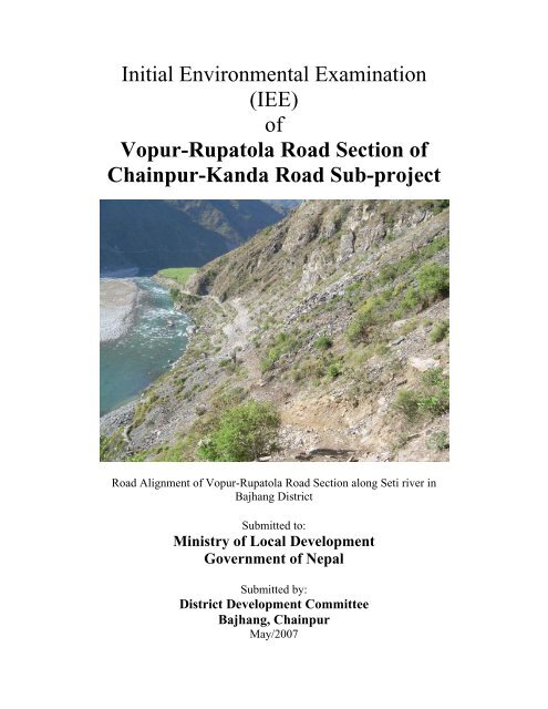
Initial Environmental Examination(IEE)<strong>of</strong><strong>Vopur</strong>-<strong>Rupatola</strong> <strong>Road</strong> <strong>Section</strong> <strong>of</strong><strong>Chainpur</strong>-<strong>Kanda</strong> <strong>Road</strong> Sub-project<strong>Road</strong> Alignment <strong>of</strong> <strong>Vopur</strong>-<strong>Rupatola</strong> <strong>Road</strong> <strong>Section</strong> along Seti river inBajhang DistrictSubmitted to:Ministry <strong>of</strong> Local DevelopmentGovernment <strong>of</strong> NepalSubmitted by:District Development CommitteeBajhang, <strong>Chainpur</strong>May/2007
TABLE OF CONTENTSABBREVIATIONSEXECUTIVE SUMMARY (NEPALI)EXECUTIVE SUMMARYSALIENT FEATURES OF THE PROJECT1.0 Introduction 1-11.1 Background 1-11.2 Relevancy <strong>of</strong> the proposal 1-11.3 Name and address <strong>of</strong> the proponent 1-21.4 Description <strong>of</strong> the proposal 1-21.5 Construction approach 1-41.6 Objectives 1-51.5 Methodology adopted 1-52.0 Review <strong>of</strong> Relevant Acts, Regulations and Guidelines 2-13.0 Existing Environmental Conditions 3-13.1 Physical environment 3-13.2 Biological environment 3-43.3 Socioeconomic and cultural environment 3-54.0 Project Alternatives 4-14.1 No action option 4-14.2 Proposal alternatives 4-14.3 Alternative design and construction approach 4-24.4 Alternative schedule and process 4-24.5 Alternative resources 4-25.0 Identification and Assessment <strong>of</strong> Impacts 5-15.1 Beneficial impacts 5-15.2 Adverse impacts 5-36.0 Mitigation measures 6-16.1 Benefit augmentation measures 6-16.2 Adverse impacts mitigation measures 6-27.0 Environmental Management plan 7-17.1 Institution and their roles 7-17.2 Reporting and Documentation 7-27.3 Environment Management Plan 7-37.4 Mitigation Cost 7-6_________________________________________________________________________________________<strong>Vopur</strong>-<strong>Rupatola</strong> <strong>Section</strong> <strong>of</strong> <strong>Chainpur</strong>-<strong>Kanda</strong> <strong>Road</strong>, Bajhang Page 1 <strong>of</strong> 2Initial Environmental Examination (IEE)
7.5 Environmental Monitoring 7-67.5.1 Monitoring responsibility 7-67.5.2 Types <strong>of</strong> Monitoring and Monitoring Parameters 7-78.0 Conclusion and recommendation 8-19.0 Miscellaneous 9-1Figures1-1 Map <strong>of</strong> Nepal showing road location in the district 1-31-2 Map <strong>of</strong> Bajhang district showing <strong>Vopur</strong>-<strong>Rupatola</strong> road sub-project 1-41-3 Map showing alignment <strong>of</strong> <strong>Vopur</strong>-<strong>Rupatola</strong> road sub-project 1-57-1 Environmental Management Organization Structure 7-3Tables1-1 Project activities <strong>of</strong> the road 1-23-1 Topography, geology and soil type 3-23-2 Streams along the road 3-33-3 Land use pattern 3-33-4 Community forest along the road 3-43-5 Settlements and population 3-55.1 Summary <strong>of</strong> environmental impacts 5-67-1 Framework <strong>of</strong> implementation environmental management plan 7-47-2 Environmental monitoring cost 7-77-3 Framework for monitoring environmental issues 7-8ANNEXESAnnexesAnnex IAnnex IIAnnex IIIAnnex IVAnnex VAnnex VIAnnex VIIAnnex VIIIAnnex IXAnnex XAnnex XITerms <strong>of</strong> Reference for IEE studyAbstract <strong>of</strong> costPublic noticeDeed <strong>of</strong> enquiry (muchulka)Name <strong>of</strong> organizationsRecommendation letters from VDCsa. Distribution <strong>of</strong> household by major occupationb. Summary <strong>of</strong> public services and infrastructures according to settlementc. Land holding pattern <strong>of</strong> settlements within ZoId. Number <strong>of</strong> households belonging to different food security categoryList <strong>of</strong> persons contactedList <strong>of</strong> tressMinimization <strong>of</strong> slope cutting and preservation <strong>of</strong> vegetation coverPhotographs<strong>Vopur</strong>-<strong>Rupatola</strong> <strong>Section</strong> <strong>of</strong> <strong>Chainpur</strong>-<strong>Kanda</strong> <strong>Road</strong>, Bajhang Page 2 <strong>of</strong> 2Initial Environmental Examination (IEE)
______________________________________________________________________________ABBREVIATIONSAADBBBGAsian Development BankBuilding GroupCCh ChainageCBO Community Based OrganizationCEA Country Environmental AnalysisCF Community ForestCFUG Community Forest Users GroupCISC Central Implementation SupportConsultantsCITES Convention on International Trade inEndangered Species <strong>of</strong> Flora andFaunaEIAEMPEMSEPAEPRESDFFGDGGoNGISHHaHhEnvironmental Impact AssessmentEnvironmental Management PlanEnvironmental Management <strong>Section</strong>Environmental Protection ActEnvironmental Protection RulesEnvironment Screening DocumentFocus Group DiscussionGovernment <strong>of</strong> NepalGeographical Information SystemHectareHouseholdDDADO District Agriculture DevelopmentOfficeDDC District Development CommitteeDFO District Forest Office/OfficerDG Director GeneralDISC District Implementation SupportConsultantsDIT District Implementation TeamDoLIDAR Department <strong>of</strong> LocalInfrastructure Development andAgricultural <strong>Road</strong>sDPO District Project OfficeDRCC District <strong>Road</strong> CoordinationCommitteeDTO District Technical OfficeDRILP Decentralized Rural Infrastructure andLivelihood ProjectDTMP District Transport Master PlanEEAEASEnvironmental AssessmentEnvironmental Assessment SpecialistIIEEJKKmInitial Environmental ExaminationKilometerLLDO Local Development OfficerLEP Labour based, environment friendlyand participatoryLRMP Land Resource Management ProjectMMmeterMoPE Ministry <strong>of</strong> Population andEnvironmentMoEST Ministry <strong>of</strong> Environment, Scienceand TechnologyMl MilliliterMLD Ministry <strong>of</strong> Local Development______________________________________________________________________________________<strong>Vopur</strong>-<strong>Rupatola</strong> <strong>Section</strong> <strong>of</strong> <strong>Chainpur</strong>-<strong>Kanda</strong> <strong>Road</strong>, Bajhang Page 1 <strong>of</strong> 2Initial Environmental Examination (IEE)
NNGO Non-Governmental OrganizationNRs Nepali RupeesNTFPs Non timber forest productsOOPOperational PlanSMSMCTTAToRTWSSocial MobilizerSocial Mobilization CoordinatorTechnical AssistanceTerms <strong>of</strong> ReferenceTechnical Walkover SurveyPPAM Project Administrative MemorandumPCU Project Coordination UnitQRRES Rapid Environmental ScreeningRIDP Rural Infrastructure DevelopmentProjectRS Resettlement SurveyUVVDC Village Development CommitteeVWRCC Village Works and <strong>Road</strong>Construction CommitteeWXSSASDCSocial AppraisalSwiss Agency for Development andCooperationYZZoIZone <strong>of</strong> Influence______________________________________________________________________________________<strong>Vopur</strong>-<strong>Rupatola</strong> <strong>Section</strong> <strong>of</strong> <strong>Chainpur</strong>-<strong>Kanda</strong> <strong>Road</strong>, Bajhang Page 2 <strong>of</strong> 2Initial Environmental Examination (IEE)
____________________________________________________________________________Executive SummaryThe proposed 17.923 km long <strong>Vopur</strong>-<strong>Rupatola</strong> road section is the part <strong>of</strong> the <strong>Chainpur</strong>-<strong>Kanda</strong><strong>Road</strong> (55km) in Bajhang district <strong>of</strong> Far-Western Development region. The road starts from <strong>Vopur</strong>bazar <strong>of</strong> <strong>Chainpur</strong> VDC (1.5 km east <strong>of</strong> <strong>Chainpur</strong>) and passes through Sunnikot VDC and ends at<strong>Rupatola</strong> in Dhamena VDC. The altitude <strong>of</strong> the road alignment ranges from 1350 meter at <strong>Vopur</strong>to 1700 meter at <strong>Rupatola</strong>. The road width is 5m while the total length <strong>of</strong> proposed road sectionfor construction is 17.923 km up to <strong>Rupatola</strong>. The total project cost is NRs. 148,581,614.40 andper km cost is NRs. 8, 289,996.90 (equivalent to US $ 129,531)Bajhang district is connected with the other part <strong>of</strong> the country by Jai Prithivi Bahadur SinghMarg, an earthen feeder road up to Tamail. However, the district headquarter, <strong>Chainpur</strong> is aboutto be linked from Tamail which is two hours walking distance. The main means <strong>of</strong> transportationfor the large area <strong>of</strong> the district is trail routes. Consequently, transportation <strong>of</strong> goods and servicesfrom the market centers to the rural areas and vice-versa has been difficult, insufficient andcostly. The proposed road project provides connectivity to district headquarters <strong>of</strong> Bajhang for thepeople <strong>of</strong> north eastern part <strong>of</strong> the district. Similarly, this road will also open the easyaccessibility for the people to visit Mansarovar and Kailash Parbat in Tibet which are thereligious sites for the Hindus. Moreover, this road will provide better opportunities to the touristfor adventurous trekking and expedition <strong>of</strong> Saipal Himal.This road will save considerable travel time and improve income generation potentials, enhancecommercial opportunities, improve market facilities due to easy access to Tibet, an autonomousregion <strong>of</strong> China. This road project will also provide short term employment opportunity byengaging the rural poor people in the construction <strong>of</strong> road. Such people based developmentefforts will reinstall economic activities in the area by creating long term employment and otheropportunities.The District Development Committee (DDC), Bajhang is the executing agency at the district levelunder DRILP and the proponent <strong>of</strong> the Initial Environmental Examination (IEE) study for <strong>Vopur</strong>-<strong>Rupatola</strong> road sub-project.The main objective <strong>of</strong> the IEE study is to identify the impacts <strong>of</strong> physical, biological, socioeconomicand cultural environment <strong>of</strong> the sub-project area. The specific objectives <strong>of</strong> theproposed IEE study include to:• identify the major issues that may arise as a result <strong>of</strong> proposed works on bio-physical,socio-economic and cultural environment <strong>of</strong> the project area,• recommend practical and site specific environmental mitigation and enhancementmeasures, prepare and implement environmental monitoring plan for the sub-project, and• recommend whether the IEE is sufficient for the proposed road or whether EIA will berequired as a result <strong>of</strong> the environmental issues that may arise due to the projectimplementation.______________________________________________________________________________________<strong>Vopur</strong>-<strong>Rupatola</strong> <strong>Section</strong> <strong>of</strong> <strong>Chainpur</strong>-<strong>Kanda</strong> <strong>Road</strong>, Bajhang Page 1 <strong>of</strong> 4Initial Environmental Examination (IEE)
The findings and conclusions <strong>of</strong> the report are based on the analysis <strong>of</strong> the information collectedfrom the field during May 2007 by undertaking a walk-through environmental survey along theproposed route and secondary information supplemented by information collected by the socialand technical teams working on the resettlement survey and detail survey.The dominant forest and fodder species reported in the lower part <strong>of</strong> the road alignment areGrewia oppositifolia (Bhimal), Celtis australis (Khari), Khirro, Bauhinia variegate (Koiralo),Sapindus mukorissi, (Ritha), Toona ciliate (Tooni) and in the upper part Prunus cerasoides(Paiyu), Rhododendron arboreum (Lali Gurans), Myrica esculenta (Kaphal), Alnus nepalensis(Utis), Pinus roxburghii (khote salla), Quercus semecarpifolia (Bajh), etc. The main NTFPspecies found along the road alignments are: Allo, Rubia manjith (Majitho), Gaultheriafragrantissima (Dhasingare), Acorus calamus (bojo), Barberis aristata (Chutro), Ruspberry(Aiselu) etc.There are four community forests namely, Masta, Sitalikhola, Tirmalikhan and GolibhidComminity Forest and Deusini proposed CF (under the process <strong>of</strong> handing over) along the roadalignment. The road does not fall under any protected area or buffer zone.Panthera pardus (Leopard), Muntiacus muntjak (Barking deer), Hystix indica (Porcupine), Canisaureus (Jackal), Macaca mulatta (Monkey), Felis chaus (Jungle Cat) are the wild animalsreported in the proposed road area. Similarly birds are Lophura lencomelana (kalij pheasant),Lophophorus (Danphe), Columba livia (Pigion), etc. The road does not fall under any protectedor buffer zone area. The main species <strong>of</strong> fish found in Seti River (which falls in the watershed <strong>of</strong>proposed road) is Schizotharax sps. (Asla).There are 30 settlements along the ZoI <strong>of</strong> the proposed road alignment in <strong>Chainpur</strong>, Sunikot,Dhamena, Bhatekhola, Melbisauna, Rilu and Kot Dewal VDCs. with total population <strong>of</strong> 11,498persons (1,981 households) and average family size <strong>of</strong> 5.8. Diverse ethnic groups such as,Brahmin (Joshi), Chhetri (Rokaya, Bam, Khati, Khadka, Kuwar, Dhami, Bohara, Aidi, Kathayat,Rawal) Newar and occupational caste (Damai, Kami, Sarki) live along the ZoI <strong>of</strong> road alignment.Occupational caste households are distributed in almost all the settlements.The main occupation <strong>of</strong> the people residing in the ZoI <strong>of</strong> the proposed road alignment isagriculture and livestock. Due to the lack <strong>of</strong> transportation facilities and mountainous terrain,agriculture farming is not enough for subsistence level. Therefore, people are carrying out othereconomic activities like employment as porter and labour, working in government and nongovernment organizations, business and cottage industries. A significant section <strong>of</strong> theeconomically active male population goes out to various parts <strong>of</strong> India to obtain employment asporter, labour and watchman. Earnings <strong>of</strong> people going to India play significant role in thelivelihood <strong>of</strong> the people.Beneficial ImpactsThe development efforts particularly the development <strong>of</strong> transportation network will havemultifold beneficial impacts. The immediate beneficial impacts from road development areapparent in the construction phase like there will be various employment opportunities (13,592skilled and 444,367 unskilled person days) for the local population, supports for the transfer <strong>of</strong>construction work skills and technical know-how to the local workers.During operation stage, an improved road access will bring an improvement <strong>of</strong> food securitysituation and overall economic and social stability. The road will also provide cheap, safe and fast______________________________________________________________________________________<strong>Vopur</strong>-<strong>Rupatola</strong> <strong>Section</strong> <strong>of</strong> <strong>Chainpur</strong>-<strong>Kanda</strong> <strong>Road</strong>, Bajhang Page 2 <strong>of</strong> 4Initial Environmental Examination (IEE)
transport <strong>of</strong> goods and services from rural areas to urban centers and vice versa. The farmers willbe more interested to increase agricultural production due to market accessibility. This willcontribute significantly to increase the productivity in rural areas and eventually improve theoverall socio-economic condition <strong>of</strong> the people.Once this road is on operation, trade and business activities will be further promoted. There is apossibility <strong>of</strong> increased economic opportunities and significant growth and extension <strong>of</strong> the localmarkets along the road alignment like in <strong>Vopur</strong>, Sunikot, Sera, Basti and Dhamena. In addition,construction <strong>of</strong> road will lead to appreciation <strong>of</strong> land values particularly near the market andsettlement areas.Adverse ImpactsThe physical adverse impacts during construction will be due to change in land use, slopeinstability and air, dust and water pollution, quarry sites and spoil disposal. Similarly, biologicalimpacts during construction and rehabilitation will be loss <strong>of</strong> 4.46 ha <strong>of</strong> forest area anddisturbance to wildlife and bird habitat. From these forests and private land, total 503 numbers <strong>of</strong>trees will be cleared. Socio-economic impacts during road construction and rehabilitation will beloss <strong>of</strong> 13.143 ha <strong>of</strong> agricultural land, 0.30 ha <strong>of</strong> temple land, loss <strong>of</strong> private properties andexposure to health and safety problems during road construction.The adverse physical impacts during road operation are slope instability and management, air andnoise pollution, road safety. Likewise, biological impacts are depletion <strong>of</strong> forest resources anddisturbance to wildlife. Socioeconomic impacts are due to new settlement and market centerdevelopment, change in social behavior, loss <strong>of</strong> occupation by the porters and discontinue in thetransportation by ram and sheep during road operation.Mitigation MeasuresImpacts from the proposed road projects can be both beneficial as well as adverse. An effectiveimplementation <strong>of</strong> benefit maximization measures and adverse impacts mitigation measureswould optimize the benefits expected from the project and avoid/minimize the adverse impactfrom the project. Based on the impact assessment and identification, beneficial augmentation andadverse impact mitigation measures are presented in both constructions as well as in operationstage <strong>of</strong> the road.Environmental Management PlanEnvironmental management plan is an important tool to ensure the implementation andmonitoring <strong>of</strong> mitigation measures for minimizing adverse impacts and maximizing the beneficialimpacts. Similarly, environmental monitoring generates useful information and improves thequality <strong>of</strong> implementation <strong>of</strong> mitigation measures. The proponent, DDC Bajhang will developmonitoring mechanism to show its additional commitment for environmental improvement andmitigate undesirable environmental changes, if any during construction and operational stage.DDC will be supported by DIT (DPO and DISC) team in the district and Environmental teamfrom the CISC for the environmental monitoring.Conclusion and RecommendationThe IEE study <strong>of</strong> the proposed <strong>Vopur</strong>-<strong>Rupatola</strong> section <strong>of</strong> <strong>Chainpur</strong>-<strong>Kanda</strong> road project revealsthat the benefits from the implementation <strong>of</strong> the proposed road project are more significant andlong term in nature against the adverse impacts most <strong>of</strong> which could be mitigated or avoided.Therefore, this IEE is sufficient for approval <strong>of</strong> the proposed sub-project. This sub-project is______________________________________________________________________________________<strong>Vopur</strong>-<strong>Rupatola</strong> <strong>Section</strong> <strong>of</strong> <strong>Chainpur</strong>-<strong>Kanda</strong> <strong>Road</strong>, Bajhang Page 3 <strong>of</strong> 4Initial Environmental Examination (IEE)
ecommended for implementation with incorporation <strong>of</strong> mitigation measures and environmentalmonitoring plan.A Resettlement Plan will be required to ensure that the persons affected by the losses are properlycompensated.______________________________________________________________________________________<strong>Vopur</strong>-<strong>Rupatola</strong> <strong>Section</strong> <strong>of</strong> <strong>Chainpur</strong>-<strong>Kanda</strong> <strong>Road</strong>, Bajhang Page 4 <strong>of</strong> 4Initial Environmental Examination (IEE)
ef]k'/ - ?kftf]nf ;8s v08sf] k|f/lDes jftfj/0fLo k/LIf0f k|ltj]bgsfo{sf/L ;f/f+zk|:tfljt !&=(@# ls=dL= nfdf] ef]k'/–?kftf]nf ;8s v08 %% ls=dL= nfdf] r}gk'/ ;8s pk–cf<strong>of</strong>]hgfsf] Ps efukb{5 . <strong>of</strong>] ;8s ;'b"/ klZrdf~rn ljsf; If]q cGtu{t aemfË lhNnfsf] k"j{–pQ/ efudf kb{5 . <strong>of</strong>] ;8s v08r}gk'/ uf=lj=;= sf] ef]k'/af6 z'? eO{ ;'lgsf]6 uf=lj=;= x'“b} wd]gf uf=lj=;= sf] ?kftf]nfdf 6'lËG5 . <strong>of</strong>] ;8sv08 !#%) dL6/ b]lv !&)) dL6/sf] prfO{ eP/ hfG5 . <strong>of</strong>] ;8ssf] rf}8fO{ % dL= / hDdf nDafO{ ?kftf]nf ;Dd!&=(@# ls=dL= kb{5 h'g g<strong>of</strong> lgdf{0fsf] nflu k|:tfljt ul/Psf] 5 . k|:tfljt ;8ssf] hDdf nfut g]?!$*,%*!,^!$.$) kb{5 .aemfË lhNnfnfO{ b]zsf] cGo efu;“u ho k[YjL axfb'/ l;+x /fhdfu{ -w'n] ;8s_ n] hf]8]sf] 5 . h'g xfnnfO{td]n;Dd ag]sf] 5 . td]naf6 r}gk'/ ;b/d'sfd k'Ug @ 306f lx+8\g' kb{5 . lhNnfdf 3f]8]6f] tyf uf]/]6f]af6fx?af6 <strong>of</strong>tf<strong>of</strong>t ;+rfng ul/G5 . o;} sf/0f u|fdL0f If]qjf6 ahf/ If]qdf / ahf/ If]qjf6 u|fdL0f If]qdfljleGg ;fdfgsf] cf];f/ k;f/ ug{ s7Lg x'g'sf ;fy} dx+uf] kg{ hfG5 . k|:tfljt ;8sn] k"j{ tyf pQ/ If]qsfafl;Gbfx?sf] ;b/d'sfd ;Ddsf] kx“rnfO{ ;lhnf] t'N<strong>of</strong>pg] 5 . ;fy} dfg;/f]j/ tyf s}nfz hfg] lty{<strong>of</strong>qLx?nfO{;lhnf] x'g]5 . o;sf ;fy} o; ;8sn] ko{6sx?nfO{ ;fOkfn lxdfn;Ddsf] ;fxl;s kb<strong>of</strong>qf cle<strong>of</strong>gdf hfg /fd|f]cj;/ k|bfg ug]{5 .<strong>of</strong>] ;8ssf] lgdf{0f tyf ;+rfngjf6 ;dosf] jrt x'g'sf ;fy} cfo cfh{gsf ;+efjgfx? a9ghfg] tyf rLgsf]:jzfl;t If]q tLAatsf] ahf/ ;Ddsf] kx'“r ;lhnf] eO{ Joj;fosf cj;/x? a9g]5g\ . ;fy} ;8s lgdf{0f x'“bf:yfgLo jfl;Gbfn] /f]huf/Lsf cj;/ kfpg] 5g\ . o:tf k|ToIf kmfO{bf lbg] sfo{s|djf6 To; If]qsf] cfly{s ultljwLa9g'sf] ;fy} cGo /f]huf/Lsf cj;/x? >[hgf x'g] 5g\ .ljs]Gb|Lt u|fdL0f k"jf{wf/ tyf hLljsf]kfh{g ;'wf/ sfo{s|d cGt/ut lhNnfdf sf<strong>of</strong>{Gjog lgsfosf] lhDd]jf/LlhNnf ljsf; ;ldlt, aemfËsf] ePsf]n] ef]k'/–?kftf]nf ;8s v08sf] k|f/lDes jftfj/0fLo k/LIf0fsf] k|:tfjsklg lhNnf ljsf; ;ldlt, aemfË xf] .k|f/lDes jftfj/0fLo k/LIf0f k|ltj]bg cWoogsf] d'Vo p2]Zo pk-cf<strong>of</strong>]hgf If]qsf] ef}lts, h}ljs, ;fdflhs,cfly{s tyf ;f+:s[lts jftfj/0fdf kg]{ k|efjx? kQf nfufpg' xf] . cGo p2]Zox? lgDgfg';f/ 5g\ M‣ pkcf<strong>of</strong>]hgf If]qdf ul/g] ljleGg lgdf{0f sfo{x?n] ubf{ ef}lts, h}ljs, ;fdflhs, cfly{s tyf ;f+:s[ltsjftfj/0fdf kg]{ d'Vo c;/x? kQf nufpg' .‣ jftfj/0fdf kg]{ gsf/fTds k|efjsf] Go"lgs/0fsf pkfox? / ;sf/fTds k|efj a9fpg] pkfox? af/];'emfj lbg'sf ;fy} jftfj/0fLo cg'udg <strong>of</strong>]hgf agfO{ sf<strong>of</strong>{Gjog u/fpg' .‣ k|:tfljt ;8s cf<strong>of</strong>]hgfsf] nflu k|f/lDes jftfj/0fLo kl/If0f dfq u/] k'U5 ls jftfj/0fLo c;/n] ubf{p7g] ;jfnsf sf/0f jftfj/0fLo k|efj d"N<strong>of</strong>Íg cWoog ug'{ kg]{ s'/fsf] lgS<strong>of</strong>}{n u/L ;'emfj ug]{ .dO{ @))& df lkmN8 ;j]{If0fjf6 lnOPsf tY<strong>of</strong>Í tyf cGo pknAw tY<strong>of</strong>Íx?sf] ;fy} ;fdflhs tyf k|fljlws6f]nLjf6 k'gjf{; sfo{sf] ;e]{If0fsf] nflu ;+sng u/]sf tY<strong>of</strong>Íx? s]nfP/ k|f/lDes jftfj/0fLo k/LIf0f k|ltj]bgt<strong>of</strong>/ u/L lgisif{ tyf ;'emfjx? lbOPsf 5g\ .o; ;8s v08sf] tNnf] e]udf kfOg] ?vx?sf] k|hftLx?df eLdn, v/L, lv/f]{, sfkmn, af“em, sf]O/fnf], /Lf, 6'gLcflb / dflyNnf] efudf k}o'+, nflnu'/f“;, plQ;, vf]6] ;Nnf, af“em tyf u}¥x sfi7 jg k}bfjf/df cNnf], dlh7f],w;L+u]/], af]emf], r'qf], P]+;]n' cflb kb{5g\ . <strong>of</strong>] ;8s v08 d:6f, l;tnLvf]nf, lt/dnLvfg / uf]nLle+8 ;fd'bflosjgsf ;fy} b]p;LgL k|:tfljt ;fd'bflos jg eP/ hfG5 . lrt'jf, d[u, b'D;L, :<strong>of</strong>n, h+unL lj/fnf] cflb jGohGt'sf ;fy} sflnh, 8f“km], k/]jf, cflb k+IfLx? o; ;8s v08 eP/ hfg] jgdf kfOG5g\ . ;8s v08sf] hnfwf/If]qdf kg]{ ;]tL gbLdf c;nf df5fx? kfOG5g\ .<strong>of</strong>] ;8s v08sf] k|efljt If]q leq r}gk'/, ;'gLsf]6 / wd]gf uf=lj=;=sf] #) j6f j:tLx? kb{5g\ . hDdf 3/w'/L;+V<strong>of</strong> !(*! / hg;+V<strong>of</strong> !!$(* /x]sf] 5 . oxf“ j;f]jf; ug]{ ljleGg hft hfltsf dflg;x?df d'Vo u/L a|fxd0f,If]qL, g]jf/ tyf blnt -bdfO{, sfdL / ;fsL{_ hfltx? kb{5g\ . blntx? ;j} j:tLx?df 5l/P/ a;]sf 5g\ .oxf“sf afl;Gbfx?sf] d'Vo k];f s[lif / kz'kfng xf] . <strong>of</strong>tf<strong>of</strong>tsf] c;'ljwfn] ubf{ tyf kxf8L If]q ePsf]n] s[lifpAhgLn] dfq k<strong>of</strong>{Kt gx'g] x'“bf oxf“sf dflg;x?sf] cGo k]zfdf s'NnLsf] ?kdf sfd ug]{, ;/sf/L tyf cGoef]k'/–?kftf]nf ;8s v08sf] k|f/lDes jftfj/0fLo k/LIf0f k|ltj]bg 1
;+:yfdf sfd ug]{ / J<strong>of</strong>kf/ Joj;fo ug]{ ub{5g\ . clwsf+z k'?ifx? sfdsf] vf]hLdf ef/tsf ljleGg 7fp“df hfg]ub{5g\ h'g\ hLljsf]kfh{gsf] d'Vo cfwf/ xf] .;sf/fTds k|efjM<strong>of</strong>tf<strong>of</strong>tsf] ;'ljwfn] :yflgo afl;Gbfx?sf] hLjgdf y'k}| ;sf/fTds k|efj kb{5g\ . ;8s lgdf{0f ubf{ :yfgLojfl;Gbfx?n] >dLssf] ?kdf -!#,%(@ bIf >dLs / $$$,#^& cbIf >dLs_ /f]huf/Lsf cj;/x? k|fKt ug]{ /k|fljlws zLk tyf 1fg ;d]t k|fKt ug]{ 5g\ .;8s lgdf{0f eO{ ;+rfngsf] cj:yfdf To; If]qdf vfBfgsf] cfk"lt{ ;'rf? x'g uO{ cfly{s tyf ;fdflhs :yfoLTja9\g hfg]5 . ;fy} ;8s <strong>of</strong>tf<strong>of</strong>tn] ubf{ u|fdL0f e]ujf6 ahf/ If]q / ahf/ If]qjf6 u|fdL0f e]udf ;]jf tyf;fdfgx?sf] cf];f/ k;f/ l56f], 5l/tf], ;'ne tyf ;:tf] x'g hfg]5 . ahf/df kx'“r ePsf] sf/0f s[lif pTkfbga9fpg s[ifsx? pT;fxL x'g]5g\ . o:n] ubf{ pTkfbsTjdf j[l4 eO{ cGttf]uTjf u|fdL0f e]usf afl;Gbfsf] hLjg:t/df ;'wf/ x'g hfg] 5 .;8s ;+rfng x'“bf J<strong>of</strong>kf/ Joj;fodf j[l4 x'g hfg]5 . ef]k'/, ;'gLsf]6, ;]/f, j:tL tyf wd]gfdf J<strong>of</strong>kf/ If]qsf]ljsf; eO{ oxf“sf afl;Gbfx?sf] hLjg :t/df ;'wf/ x'g hfg]5 . ahf/ If]qsf] ljsf;n] ubf{ hUufsf] d"Nodf ;d]tj[l4 x'g hfg]5 .gsf/fTds k|efjM;8s lgdf{0f ubf{ ef}lts jftfj/0fdf kg]{ gsf/fTds k|efjx?df e"-:jfdLTjsf] k|<strong>of</strong>]udf jbnfj, le/fnf] hUufdfklx/f] hfg], jfo' tyf kfgLdf k|b"if0f, vg]sf] df6f] kmflnbf kg]{ k|efjx? d'Vo 5g\ . o:t} k|sf/ h}ljs k|efjcGt/ut $=$^ x]S6/ jg tyf JolQmut hUufx?jf6 %)# ?vx? sfl6g] 5g\ . ;fy} jGohGt'sf] a;f]jf;dfcK7\<strong>of</strong>/f] kg{ hfg]5 . cfly{s tyf ;fdflhs k|efj cGt/ut ;8s lgdf{0f ubf{ !#=!$# x]S6/ v]tL ul/g] hdLg,tyf )=#) x]S6/ dlGb/sf] hdLg gf]S;fgL kg'{sf ;fy} cGo ;DklQ ;d]tsf] gf]S;fgL x'g hfg]5 . o;sf ;fy}>dLs tyf cGo afl;Gbfx?sf] :jf:Yodf ;8s lgdf{0f x'“bf k|lts'n c;/ kg{ hfg]5 . :yfgLo jfl;Gbfsf 3/,s6]/f, 6x/f, r/Lr/0fsf hUufx? ;8sdf k/L gf]S;fgL x'g]5g\ .;8s ;+rfngsf] bf}/fg ef}lts jftfj/0fdf kg]{ gsf/fTds c;/x?df le/fnf]kgsf] :yfloTj / o;sf] Joj:yfkg,jfo' tyf WjgL k|b'if0f tyf ;8s ;'/Iffsf ;d:<strong>of</strong>x? kb{5g\ . o;} k|sf/ h}ljs k|efjdf jGo >f]t 36\g', jGohGt'x?nfO{ cK7]/f] kg'{ x'g\ eg] ;fdflhs tyf cfly{s k|efjx?df g<strong>of</strong>“ j:tL / ahf/sf] cJojl:yt lj:tf/,;fdflhs Jojxf/df kl/jt{g tyf el/<strong>of</strong>x?sf] /f]huf/L aGb x'g' tyf e]8f tyf R<strong>of</strong>ª\u|faf6 ul/g] 9'jfgL aGb x'g'cflb kb{5g\ .k|efj Go"gLs/0fsf pkfoMo; ;8ssf] lgdf{0fjf6 ;sf/fTds tyf gsf/fTds b'j} k|sf/sf k|efjx? kg]{ b]lvG5g\ . ;sf/fTds k|efj a9fpg]pkfox? tyf gsf/fTds k|efj Go"gLs/0f ug]{ pkfox?sf] k|efjsf/L sf<strong>of</strong>{Gjogn] ubf{ ;sf/fTds k|efj j9\ghfg'sf ;fy} gsf/fTds k|efj Go"g ug{ ;lsg] jf x6fpg ;lsg] 5g\ . k|efjx?sf] cf+sngsf] cfwf/df ;8slgdf{0f tyf ;+rfng b'j} r/0fdf ;sf/fTds k|efj a9\g] pkfo / gsf/fTds k|efj 36fpg] pkfox? pNn]vul/Psf 5g\ .jftfj/0fLo Aoa:yfkg <strong>of</strong>]hgfM;sf/fTds c;/x?nfO{ a9fpg] / gsf/fTds c;/x?nfO{ 36fpg jftfj/0fLo Aoa:yfkg <strong>of</strong>]hgf Pp6f dxTjk"0f{pkfo xf] . o;n] ubF{ cfjZosLo ;"rgfx? k|fKt eO{ k|efj Go"gLs/0fsf pkfox?sf] sf<strong>of</strong>{Gjogdf ;'wf/ ug{;lsG5 . o;sf] nflu lhNnf ljsf; ;ldlt -lh=lj=;=_, aemfËn] cg'udg k|0ffnLsf] ljsf; u/L jftfj/0fLo;'wf/df cfkm\gf] k|ltj4tf b]vfpg] 5 . o; sfdsf] nflu lh=lj=;= nfO{ lhNnfdf /x]sf] <strong>of</strong>]hgf sf<strong>of</strong>{Gjog sfo{fno/ lhNnf sf<strong>of</strong>{Gjog ;x<strong>of</strong>]u k/fdz{bftfx? / s]Gb|Lo sf<strong>of</strong>{Gjog ;x<strong>of</strong>]u k/fd{zbftfn] ;x<strong>of</strong>]u k'¥<strong>of</strong>pg] 5g\ .lgisif{ tyf ;'emfjx?Mef]k'/–?kftf]nf ;8s v08sf] k|f/lDes jftfj/0fLo k/LIf0f k|ltj]bgn] ;sf/fTds k|efjx? gsf/fTds k|efjsf]t'ngfdf j9L dxTjk"0f{ /x]sf] / nfdf] ;do;Dd /xg] / gsf/fTds k|efjx? Go"gLs/0f ug{ ;lsg] s'/f b]vfp“5, o;sf/0f <strong>of</strong>] ;8s pkcf<strong>of</strong>]hgfsf] :jLs[tLsf] nflu k|f/lDes jftfj/0fLo k/LIf0f k|<strong>of</strong>{Kt /x]sf] 5 . k|efjx?sf]Go"gLs/0f / ;+nUg jftfj/0fLo cg'udg <strong>of</strong>]hgf sf<strong>of</strong>{Gjog u/L k|:tfljt pkcf<strong>of</strong>]hgf sf<strong>of</strong>{Gjogsf] nflul;kmfl/; ul/G5 .;8s lgdf{0f ubf{ k|efljt JolQmx?sf] ;DklQsf] IftLk"tL{ ug{ k'gjf{; <strong>of</strong>]hgsf] cfjZostf kg]{5 .ef]k'/–?kftf]nf ;8s v08sf] k|f/lDes jftfj/0fLo k/LIf0f k|ltj]bg 2
SALIENT FEATURES1. Name <strong>of</strong> the Project : <strong>Vopur</strong>-<strong>Rupatola</strong> <strong>Road</strong> <strong>Section</strong> <strong>of</strong> <strong>Chainpur</strong>-<strong>Kanda</strong><strong>Road</strong> Sub-project2. Location2.1 Geographical Location2.1.1 Start Point : <strong>Vopur</strong> bazar <strong>of</strong> <strong>Chainpur</strong> VDC2.1.2 End Point : <strong>Rupatola</strong> in Dhamena VDC2.2 Geographical Features2.2.1 Terrain : Hilly2.2.2 Alignment : Valley and hill2.2.3 Altitude : 1350 m to 1700 m2.2.4 Climate : Sub-tropical2.2.5 Soil : Alluvial, colluvial and residual3. Classification <strong>of</strong> road : District "A" <strong>Road</strong>4. Length <strong>of</strong> road : 17.923 km5. Major settlements5.1 Name <strong>of</strong> settlements : <strong>Vopur</strong>, Ruinabagar, Sahilabagar, Sunigad, Sunikot,Seragaon, Dhamena, Basti and <strong>Rupatola</strong>5.2 No. <strong>of</strong> households : 19815.3 VDCs along the road : <strong>Chainpur</strong>, Sunikot and Dhamena6. Cross-section6.1 Right <strong>of</strong> way : 10.0m on either side <strong>of</strong> the road6.2 Formation width : 5.0m having 5% outward slope6.3 Carriage way : 4.0 m7. Structures7.1 Dry stone causeway : 41 no.7.2 RCC bridges : 2 no.7.3 Irrigation crossing withslab culvert: 5 no.7.4 Dry stone scupper : 1 no.7.5 Retaining structures7.5.1. Dry stone wall : 11,578.48 cum7.5.2. Gabion wall : 6596.00 cum7.5.3. Stone masonry : 379.81cum7.5.4. Stone pitching : 252 no.8. Bioengineering works : NRs.1,600,000.009. Earthwork8.1 Cutting : 172,742.05 cum8.2 Filling : 26544.80 cum10. Project Cost9.1 Net Cost (NRs.) : 148,581,614.409.2 Cost per km. (NRs.) : 8, 289,996.9011. Employment generation11.1 Total person days11.1.1 Skilled : 13,59211.1.2 Unskilled : 444,36711.2 Total employment generation (no. <strong>of</strong> labourer) for 90 working days11.2.1 Skilled : 15111.2.2 Unskilled : 4,937______________________________________________________________________________________<strong>Vopur</strong>-<strong>Rupatola</strong> <strong>Road</strong>,, Bajhang Page 1 <strong>of</strong> 1Initial Environmental Examination (IEE)
________________________________________________________________________1.0 Introduction______________________________________________________________________________1.1 BackgroundThe Decentralized Rural Infrastructure and Livelihood Project (DRILP) is a project beingimplemented with Loan 2092-NEP (SF) from Asian Development Bank (ADB), grant from SwissAgency for Development and Cooperation (SDC), counterpart funding from Government <strong>of</strong> Nepal(GoN), participating districts and contributions from project beneficiaries. The loan agreement wassigned by GoN and ADB on December 23, 2004 (2061/09/08) and the loan has become effectivefrom October 31, 2005 (2062/07/15).The project goal is to reduce rural poverty in 18 very poor remote hill and mountain districtsaffected by the conflict. The purpose is to achieve sustainable increased access to economic andsocial services, and enhanced social and financial capital for people in the project area, particularlypoor and disadvantaged groups. The Project will invest in small, community socio- economicinfrastructure; and provide jobs, empower rural communities for development, increaseinstitutional capacity and improve accountability and transparency. The Project through specificrural transport subprojects will also extend the network <strong>of</strong> improved rural transport infrastructure,consisting <strong>of</strong> roads, trails and pedestrian bridges.Labor-based, environmentally friendly, and participatory (LEP) approaches will ensure that theinvestment in construction and rehabilitation <strong>of</strong> infrastructure results in sustainable, improved accessto economic and social services, and enhanced social and financial capital.Department <strong>of</strong> Local Infrastructure Development and Agricultural <strong>Road</strong>s (DoLIDAR) is theexecuting agency for DRILP supported sub-projects. The implementing arrangements are asfollowing: DoLIDAR has established a project coordination unit (PCU) in Kathmandu, headed by aproject coordinator to coordinate all project activities. The PCU will be responsible for guiding andmonitoring district development committees (DDCs) as they implement project components. At thedistrict level, project implementation will be the responsibility <strong>of</strong> the district project <strong>of</strong>fice (DPO)within the district technical <strong>of</strong>fice (DTO) <strong>of</strong> each DDC. A local engineering consultant to covertechnical issues, and a local non-government organization (NGO) engaged for social mobilizationand support for rural infrastructure building groups, will support the DPO as districtimplementation support consultants (DISC). Overall back stopping support to the district will beprovided by central implementation support consultants (CISC).1.2 Relevancy <strong>of</strong> the proposalAn IEE <strong>of</strong> the proposed road is necessary in order to assess the environmental consequences <strong>of</strong> theproposed rural road rehabilitation and construction activities and suggest appropriate, practical andsite specific mitigation and enhancement measures. It is a legal requirement by the Government <strong>of</strong>Nepal (GoN) according to article 3 <strong>of</strong> Environmental Protection Act (EPA) 1996 and rule 3 <strong>of</strong>Environmental Protection Rules (EPR) 1997 (amended in 2007) as mentioned in schedule 1.Preparation <strong>of</strong> IEE report by concerned District Development Committee (DDC) and approval <strong>of</strong>IEE report by the Ministry <strong>of</strong> Local Development (MLD) according to Nepali legal provision isconsidered sufficient by the ADB according to Project Administrative Memorandum (PAM)subject to prior review <strong>of</strong> an agreed sample <strong>of</strong> sub-project IEEs by ADB. DRILP falls under______________________________________________________________________________________<strong>Vopur</strong>-<strong>Rupatola</strong> <strong>Section</strong> <strong>of</strong> <strong>Chainpur</strong>-<strong>Kanda</strong> <strong>Road</strong>, Bajhang Page 1 <strong>of</strong> 8Initial Environmental Examination (IEE)
category B project where IEE is mandatory according to Environmental Assessment Guidelines <strong>of</strong>ADB (2003). Nepali legal provisions in essence satisfy ADB's requirements, however, ADBapproval is also required if the project cost exceeds more than $ 30,000 per km according to Reportand Recommendation <strong>of</strong> the President to the Board <strong>of</strong> Directors.This IEE report <strong>of</strong> <strong>Vopur</strong>-<strong>Rupatola</strong> <strong>Road</strong> sub-project in Bajhang district is prepared based on theTerms <strong>of</strong> Reference (ToR) approved on 2063/12/28 by the secretary level decision <strong>of</strong> the Ministry<strong>of</strong> Local Development (MLD). The approved ToR is given in Annex 1.The findings and conclusions <strong>of</strong> the report are based on the analysis <strong>of</strong> the information collectedduring May 2007 from the field by undertaking a walk-through environmental survey along theproposed route (for which a checklist was used) and secondary information, supplemented byinformation collected by the social and technical teams working on the resettlement survey anddetail survey.1.3 Name and Address <strong>of</strong> the ProponentThe District Development Committee (DDC), Bajhang is the executing agency at the district levelunder DRILP and the proponent <strong>of</strong> the Initial Environmental Examination (IEE) study for therehabilitation and construction <strong>of</strong> <strong>Vopur</strong>-<strong>Rupatola</strong> road sub-project.1.4 Description <strong>of</strong> the proposalThe proposed 17.923 km long <strong>Vopur</strong>-<strong>Rupatola</strong> road section is the part <strong>of</strong> the <strong>Chainpur</strong>-<strong>Kanda</strong> <strong>Road</strong>(55km) in Bajhang district <strong>of</strong> Far-Western Development region. The road alignment starts from<strong>Vopur</strong> bazar <strong>of</strong> <strong>Chainpur</strong> VDC (1 km east <strong>of</strong> <strong>Chainpur</strong>) and passes through Sunnikot VDC andends at <strong>Rupatola</strong> in Dhamena VDC. Thus, it passes through three VDCs namely, <strong>Chainpur</strong>,Sunnikot and Dhamena. The major settlements along the road are: <strong>Vopur</strong>, Ruinabagar, Sahilabagar,Sunigad, Sunikot, Seragaon, Dhamena, Basti and <strong>Rupatola</strong>. The altitude <strong>of</strong> the road alignmentranges from 1350 meter at <strong>Vopur</strong> to 1700 meter at <strong>Rupatola</strong>.The <strong>Vopur</strong>-<strong>Rupatola</strong> road section is also continuation to the Jai Prithivi Bahadur Singh Margpresently under construction by the Department <strong>of</strong> <strong>Road</strong> (DoR) from <strong>Vopur</strong> bazaar <strong>of</strong> <strong>Chainpur</strong>VDC. The proposed road alignment passes through the right bank <strong>of</strong> the Seti River for about 3 kmand negotiates 300m <strong>of</strong> elevation to pass through the Mastamandir Temple to reach <strong>Rupatola</strong>. Theroad width is 5m while the total length <strong>of</strong> proposed road section for construction is 17.923 km up to<strong>Rupatola</strong> for fair weather road. The total project cost is NRs. 148,581,614.40 and per km cost isNRs. 8, 289,996.90 (equivalent to US $ 129,531) as shown in Annex II.The description <strong>of</strong> the project works is given in the table 1.1 and the location <strong>of</strong> the road isillustrated by the figure 1.1 and 1.2. Likewise, the road alignment is shown by the figure 1.3.Table 1.1 Project activities <strong>of</strong> the proposed <strong>Vopur</strong>-<strong>Rupatola</strong> road section<strong>Road</strong> section Chainage Length Description<strong>Vopur</strong>-Sunigad 0+000 to 3+000 3.0 km Rehabilitation <strong>of</strong> 1 km road.Sunigad-Mastamandir 3+000 to 7+000 4.0 km New construction.Mastamandir-Dhamena 7+000 to 10+000 3.0 km New construction.Dhamena - Sukgad 10+000 to 12+300 2.3 km New construction.Sukgad-Basti 12+300 to 15+600 3.3 km New construction.Basti-<strong>Rupatola</strong> 15+600 to 17+903 2.323 km New construction.Total 17.923______________________________________________________________________________________<strong>Vopur</strong>-<strong>Rupatola</strong> <strong>Section</strong> <strong>of</strong> <strong>Chainpur</strong>-<strong>Kanda</strong> <strong>Road</strong>, Bajhang Page 2 <strong>of</strong> 8Initial Environmental Examination (IEE)
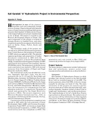
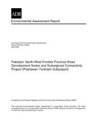
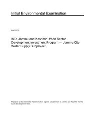
Bajhang district is connected with the other part <strong>of</strong> the country by Jai Prithivi Bahadur Singh Marg,an earthen feeder road up to Tamail. However, the district headquarter, <strong>Chainpur</strong> is about to belinked from Tamail which is about 2 hours walking distance. Construction <strong>of</strong> this road is inprogress and expected to be completed before coming rainy season. The main means <strong>of</strong>transportation for the large area <strong>of</strong> the district is trail routes. Consequently, transportation <strong>of</strong> goodsand services from the market centers to the rural areas and vice-versa has been difficult, insufficientand costly. The proposed road project provides connectivity to district headquarters <strong>of</strong> Bajhang forthe people <strong>of</strong> north eastern part <strong>of</strong> the district. Similarly, this road will also open the easyaccessibility for the people to visit Mansarovar and Kailash Parbat in Tibet which are the religioussites for the Hindus. Moreover, this road will provide better opportunities to the tourist foradventurous trekking and expedition <strong>of</strong> Saipal Himal.The proposed <strong>Vopur</strong>-<strong>Rupatola</strong> road will start from <strong>Vopur</strong> which is 1.5 km east <strong>of</strong> <strong>Chainpur</strong>connecting Jai Prithivi Bahadur Singh Marg. Direct beneficiaries <strong>of</strong> this road project will be thepeople <strong>of</strong> <strong>Chainpur</strong>, Sunikot and Dhamena VDCs and indirect beneficiaries will be the peopleliving in Rilu, Melbisauna, Kotdewal and Bhate Khola VDCs <strong>of</strong> Bajhang district. This road willsave considerable travel time and improve income generation potentials, enhance commercialopportunities, improve market access due to easy access to Tibet, an autonomous region <strong>of</strong> China.Moreover, this road will also provide short term employment opportunity by engaging the ruralpoor people in the construction and rehabilitation <strong>of</strong> the road. Such people based developmentefforts will reinstall economic activities in the area by creating long term employment and otheropportunities.Figure 1.1. Map <strong>of</strong> Nepal showing the location <strong>of</strong> <strong>Vopur</strong>-<strong>Rupatola</strong> in Bajhang District______________________________________________________________________________________<strong>Vopur</strong>-<strong>Rupatola</strong> <strong>Section</strong> <strong>of</strong> <strong>Chainpur</strong>-<strong>Kanda</strong> <strong>Road</strong>, Bajhang Page 3 <strong>of</strong> 8Initial Environmental Examination (IEE)
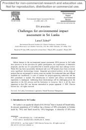
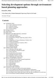
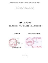
Figure 1.2. Map showing <strong>Vopur</strong>-<strong>Rupatola</strong> road in Bajhang district1.5 Construction ApproachThis road will be constructed using the labour-based, environment-friendly and participatory (LEP)approach, the important features <strong>of</strong> which are:‣ Use <strong>of</strong> local people as labour, hand tools and small equipment, rather than heavymachinery, for construction.‣ Balancing cut and fill and reuse <strong>of</strong> excavated materials as construction materials, and thusnot generating excess spoils, as far as possible.‣ Use <strong>of</strong> bio-engineering techniques: integrated use <strong>of</strong> vegetation, simple civilengineering structures and proper water management systems for slope protection.______________________________________________________________________________________<strong>Vopur</strong>-<strong>Rupatola</strong> <strong>Section</strong> <strong>of</strong> <strong>Chainpur</strong>-<strong>Kanda</strong> <strong>Road</strong>, Bajhang Page 4 <strong>of</strong> 8Initial Environmental Examination (IEE)
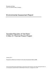
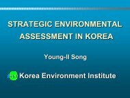
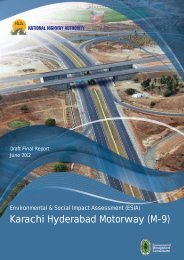
Figure 1.3. Map showing road alignment <strong>of</strong> <strong>Vopur</strong>-<strong>Rupatola</strong> road in Bajhang District1.6 ObjectivesThe main objective <strong>of</strong> the IEE study is to identify the impacts <strong>of</strong> physical, biological, socioeconomicand cultural environment <strong>of</strong> the sub-project area. The specific objectives <strong>of</strong> the proposedIEE study include to:• identify the major issues that may arise as a result <strong>of</strong> proposed works on bio-physical,socio-economic and cultural environment <strong>of</strong> the project area,• recommend practical and site specific environmental mitigation and enhancementmeasures, prepare and implement environmental monitoring plan for the sub-project, and• recommend whether the IEE is sufficient for the proposed road or whether EIA will berequired as a result <strong>of</strong> the environmental issues that may arise due to the projectimplementation.1.7 Methodology adoptedThe IEE approach, methodology and procedure were generally followed according to theprovisions <strong>of</strong> the EPA, 1996 and EPR, 1997. Data collection was done in May 2007 by the staff <strong>of</strong>DISC team (Engineer, Overseer, Social Mobiliser, Enumerators) and Environmental AssessmentSpecialist from CISC.1.71 Desk reviewThe following steps were followed during the desk review:• Collection and review <strong>of</strong> secondary information from various sources• Initial interaction and consultation with the local community and district level stakeholders______________________________________________________________________________________<strong>Vopur</strong>-<strong>Rupatola</strong> <strong>Section</strong> <strong>of</strong> <strong>Chainpur</strong>-<strong>Kanda</strong> <strong>Road</strong>, Bajhang Page 5 <strong>of</strong> 8Initial Environmental Examination (IEE)
• Delineation <strong>of</strong> geographical boundary <strong>of</strong> the influence area on the topographical map• Preparation <strong>of</strong> project specific checklist1.7.1.1 Collection and review <strong>of</strong> secondary sources <strong>of</strong> information from various sourcesSecondary information was collected through published and unpublished reports and interpretation<strong>of</strong> maps and photographs. The sources <strong>of</strong> information were District Development Committee(DDC), District Forest Office (DFO), other line agencies, related NGOs and other project <strong>of</strong>fices inthe district.1.7.1.2 Initial interaction and consultation with the local community and district levelstakeholdersDuring the IEE report preparation, EAS and DISC team met, discussed and interacted withconcerned staff <strong>of</strong> the Government <strong>of</strong> Nepal, DDC, VDCs in the district head quarter and VWRCCmembers, teachers, community based organization member and knowledgeable key persons <strong>of</strong>surrounding areas within the Zone <strong>of</strong> Influence (ZoI).1.7.1.3 Delineation <strong>of</strong> geographical boundary <strong>of</strong> the influence area on the topo-mapThe geographical boundary <strong>of</strong> ZoI (one and half hours walk from the road) was drawn on thetopographical maps with the help <strong>of</strong> DISC Engineer and SM.1.7.1.4 Preparation <strong>of</strong> project specific checklistA checklist was prepared to collect physical, biological, socio-economic and cultural environmentrelated information in the field. This check list was based on APPROACH manual produced byDoLIDAR. In addition, ZoI household survey questionnaire was used to collect socio-economicinformation <strong>of</strong> the households. Similarly, household listing survey report was used for the listing <strong>of</strong>agricultural land, forest, trees, houses and other affected properties prepared during resettlementsurvey.1.7.2 Field surveyField survey comprised <strong>of</strong> walkthrough survey, consultation with community, site inspection andobservation. The road alignment form the starting point at <strong>Vopur</strong> to end point at <strong>Rupatola</strong> wasvisited and observed. The following tools were used for the collection <strong>of</strong> primary data.• Focus group discussion (FGD) - To conduct consultation with the local communities atdifferent settlements, FGD was organized with key informants and other knowledgeablepersons. It was done to collect biological, socio-economic and cultural environment relatedinformation using a checklist• ZoI household survey - Questionnaire was used to collect socio-economic information <strong>of</strong>all the households within the ZoI.• Household listing survey - Total enumeration was done for the listing <strong>of</strong> agricultural land,forest, trees, houses and other affected properties.• Stripe map - It was used during walkthrough survey to document environmental featuresaccording to the chainage.• Topographical map - It was used to show environmental features on the map duringwalkthrough survey.• Photographs - Necessary photographs were taken to show different environmental features.1.7.3 Compilation <strong>of</strong> existing information, impact identification and predictionThe information collected from different sources were processed and analyzed according to thephysical, biological, socioeconomic and cultural environment within the zone <strong>of</strong> influence. Thecollected secondary data were the major sources for verification and crosschecking <strong>of</strong> primary data______________________________________________________________________________________<strong>Vopur</strong>-<strong>Rupatola</strong> <strong>Section</strong> <strong>of</strong> <strong>Chainpur</strong>-<strong>Kanda</strong> <strong>Road</strong>, Bajhang Page 6 <strong>of</strong> 8Initial Environmental Examination (IEE)
during the field survey. The generated information from primary source was analyzed, tabulatedand prioritized.Based on the identification <strong>of</strong> the impacts, their prediction was done to forecast the changes in localenvironment. The methods adopted in impact predictions were done by using various methods,such as trend analysis, cause and effect relationship, expert judgment etc. The assessment <strong>of</strong>environmental impact was derived exclusively in terms <strong>of</strong> magnitude, duration and extent. Thesignificance <strong>of</strong> positive and negative impacts associated with construction and subsequentoperation <strong>of</strong> the road were identified and predicted considering the ZoI.1.7.4 Mitigation Measures and Monitoring PlanBased on the identified impacts their nature, extent and magnitude, the mitigation and monitoringprescriptions were developed. A realistic approach was applied for the application <strong>of</strong> the mitigationmeasures in the local context. Environmental monitoring plan was developed to assess theeffectiveness <strong>of</strong> the mitigation measures and implementation status.1.7.5 Public consultationIn order to ensure the public involvement, the following procedures were followed during IEEreport preparation:• Publication <strong>of</strong> notice- a 15 days public notice was published on 10th <strong>of</strong> Baisakh, 2064 in theGorkhapatra, a national daily newspaper (see Annex III) seeking written opinion fromconcerned VDCs, DDC, schools, health posts and related local organizations. A copy <strong>of</strong> thepublic notice was also affixed in the above mentioned organizations and deed <strong>of</strong> enquiry(muchulka) was collected (see Annex IV for deed <strong>of</strong> inquiry and Annex V for the names <strong>of</strong>organizations). Written responses from relevant stakeholders on the public notice were alsoreviewed and documented in the report.• IEE team also carried out interaction with local communities and related stakeholders duringfield survey to collect the public concerns and suggestions. Moreover, focus group discussions(FGDs) were conducted to collect and solicit information regarding the bio-physical and socioeconomicand cultural aspects <strong>of</strong> <strong>Vopur</strong>-<strong>Rupatola</strong> section <strong>of</strong> <strong>Chainpur</strong>-<strong>Kanda</strong> road. The FGDswere held at different 30 settlements along the ZoI <strong>of</strong> the road (refer table 3.3 for the names <strong>of</strong>settlements).• Draft IEE report was sent to <strong>Chainpur</strong>, Sunikot and Dhamena VDCs for public disclosure andrecommendation letters were also obtained and given in Annex VI. Draft IEE was also kept ininformation center <strong>of</strong> DDC Bajhang for public disclosure. After reviewing draft IEE report andincorporating the suggestions from the concerned stakeholders, final IEE report was preparedand sent to PCU for approval from MLD and ADB.• The approved IEE report will be accessible to interested parties and general public.1.7.6 The Final ReportThe IEE report was prepared by Environmental Assessment Specialist with DISC support andsubmitted to DDC for review. After reviewing the final IEE report according to ToR, it will besubmitted to MLD and ADB for approval.1.7.7 Organization <strong>of</strong> the IEE ReportThe IEE report is organized as following:Table <strong>of</strong> ContentsAbbreviationsExecutive Summary (Nepali)______________________________________________________________________________________<strong>Vopur</strong>-<strong>Rupatola</strong> <strong>Section</strong> <strong>of</strong> <strong>Chainpur</strong>-<strong>Kanda</strong> <strong>Road</strong>, Bajhang Page 7 <strong>of</strong> 8Initial Environmental Examination (IEE)
Executive SummarySalient Features<strong>Section</strong> 1.0: Introduction<strong>Section</strong> 2.0: Review <strong>of</strong> Relevant Acts, Regulations and Guidelines<strong>Section</strong> 3.0: Existing Conditions<strong>Section</strong> 4.0: Project Alternatives<strong>Section</strong> 5.0: Identification and Assessment <strong>of</strong> Impacts<strong>Section</strong> 6.0: Mitigation Measures<strong>Section</strong> 7.0: Environmental Management Plan<strong>Section</strong> 8.0: Conclusion and Recommendation<strong>Section</strong> 9.0: MiscellaneousAnnexesAnnex IAnnex IIAnnex IIIAnnex IVAnnex VAnnex VIAnnex VIIAnnex VIIIAnnex IXAnnex XAnnex XITerms <strong>of</strong> Reference for IEE studyAbstract <strong>of</strong> costPublic noticeDeed <strong>of</strong> enquiry (muchulka)Name <strong>of</strong> the organizations notice pasted and deed <strong>of</strong> inquiry obtainedRecommendation letters from Municipality and VDCsa. Distribution <strong>of</strong> household by major occupationb. Summary <strong>of</strong> public services and infrastructures according to settlementc. Land holding pattern <strong>of</strong> settlements within ZoId. Number <strong>of</strong> households belonging to different food security categoryList <strong>of</strong> persons contactedList <strong>of</strong> tressMinimization <strong>of</strong> slope cutting and preservation <strong>of</strong> vegetation coverPhotographs______________________________________________________________________________________<strong>Vopur</strong>-<strong>Rupatola</strong> <strong>Section</strong> <strong>of</strong> <strong>Chainpur</strong>-<strong>Kanda</strong> <strong>Road</strong>, Bajhang Page 8 <strong>of</strong> 8Initial Environmental Examination (IEE)
______________________________________________________________________________2.0 Review <strong>of</strong> Relevant Acts, Regulations and Guidelines____________________________________________________________________________Government <strong>of</strong> Nepal has adopted various acts, regulations and guidelines to ensure theintegration <strong>of</strong> development and conservation <strong>of</strong> environment. The IEE study was being guided bythe requirements and provisions <strong>of</strong> the following acts, rules and guidelines as applicable.2.1 Environmental Protection Act (EPA) 1996Environmental Protection Act (EPA) 1996 and Environmental Protection Regulation (EPR) 1997were enforced by the government which became effective with the enforcement <strong>of</strong> EnvironmentProtection Regulations (EPR) in June 1997 and later its amendment in April 1999. The Actrequires any development project, before implementation, to pass through environmentalassessment, which may be either IEE or an EIA depending upon the location, type and size <strong>of</strong> theprojects. The Act recognizes the interdependence between development and the environment andshows the concerns for minimizing the impacts <strong>of</strong> environmental degradation on people, animal,and plant species and their physical surroundings.The Act obliges the proponent to undertake IEE and EIA <strong>of</strong> proposal, plans or projects whichmay cause changes in existing environmental condition and authorizes then (MoPE) nowMoEST) to clear all EIA and line ministries for IEE study.2.2 Environmental Protection Regulation (EPR) 1997 (amendment, 1999)The EPR, 1997 obliges the proponent to inform the public on the contents <strong>of</strong> the proposal in orderto ensure the participation <strong>of</strong> stakeholders. EPR contains the elaborative provisions on the processto be followed during the preparation and approval <strong>of</strong> projects requiring IEE and EIA includingscoping document, terms <strong>of</strong> reference, information dissemination, public consultation and hearingand environmental monitoring and auditing. Article 12 <strong>of</strong> the EPR, requires the proponent tocomply with the matters mentioned in the report and other conditions, if any, prescribed by theapproving agency or concerned agency, while Rule 13 and 14 are related to environmentalmonitoring and environmental auditing.2.3 Forest Act, 1993The use <strong>of</strong> forestland for rural road project is subject to forest law and regulation. The roadprojects need to comply with the provisions <strong>of</strong> forest law when it requires the use <strong>of</strong> forestlandfor road construction. The Act requires decision makers to take account <strong>of</strong> all forest values,including environmental services and biodiversity, not just the production <strong>of</strong> timber and othercommodities.The Forest Act, 1993 (amendment, 1998) contains several provisions to ensure the development,conservation, management and sustainable use <strong>of</strong> forest resources, based on an approved workplan. It also recognizes the importance <strong>of</strong> forests in maintaining a healthy environment. <strong>Section</strong>s68 <strong>of</strong> the Forest Act, 1993 empowers the government in case <strong>of</strong> no alternatives, to provide parts<strong>of</strong> any types <strong>of</strong> forests for the implementation <strong>of</strong> a national priority plan with assurance that itdoes not adversely affect the environment significantly. <strong>Section</strong> 49 <strong>of</strong> the Act prohibitsreclaiming lands, setting fires, grazing, removing or damaging forest products, felling trees or______________________________________________________________________________________<strong>Vopur</strong>-<strong>Rupatola</strong> <strong>Section</strong> <strong>of</strong> <strong>Chainpur</strong>-<strong>Kanda</strong> <strong>Road</strong>, Bajhang Page 1 <strong>of</strong> 3Initial Environmental Examination (IEE)
plants, wildlife hunting and extracting boulders, sand and soil from the national forest withoutprior approval.2.4 Forest Rules, 1995The Forest Rules, 1995 further elaborate legal measures for the conservation <strong>of</strong> forests andwildlife. Rule 65 <strong>of</strong> the Forest Regulation stipulates that in case the execution <strong>of</strong> any projecthaving national priority in any forest area causes any loss or harm to any local individual orcommunity, the proponent <strong>of</strong> the project itself shall bear the amount <strong>of</strong> compensation to be paid.Similarly the entire expenses required for the cutting and transporting the forest products in aforest area to be used by the approved project shall be borne by the proponent <strong>of</strong> the project.2.5 National Park and Wildlife Conservation Act, 1973The National Parks and Wildlife Conservation Act, 1973 addresses for conservation <strong>of</strong>ecologically valuable areas and indigenous wildlife. The Act prohibits any movement <strong>of</strong> a personwithout written permission within the parks and the reserves. The Act further prohibits wildlifehunting, construction <strong>of</strong> houses and huts, damage to plants and animals etc. within the park andreserve, without the written permission <strong>of</strong> the authorized person. The Act has also listed 26species <strong>of</strong> mammals, 9 species <strong>of</strong> birds and 3 species <strong>of</strong> reptiles as protected wildlife.2.6 Local Self Governance Act (1999) and Rules (2000)The Local Self Governance Act has been enacted to provide greater political, administrative andfinancial autonomy to local bodies and facilitate community participation at the local level. TheLocal Self Governance Act, 1999 empowers the local bodies for the conservation <strong>of</strong> soil, forestand other natural resources and implements environmental conservation activities. <strong>Section</strong>s 28and 43 <strong>of</strong> the Act provide the Village Development Committee (VDC) a legal mandate t<strong>of</strong>ormulate and implement programs related to the protection <strong>of</strong> the environment during theformulation and implementation <strong>of</strong> the district level plan.2.7 Land Acquisition Act, 1977 and Land Acquisition Rules, 1969The Land Acquisition Act, 1977 and the Land Acquisition Rules, 1969 are the two main legalinstruments that specify procedural matters <strong>of</strong> land acquisition and compensation. Governmentcan acquire land at any place in any quantity by giving compensation pursuant to the Act for anypublic purposes or for operation <strong>of</strong> any development project initiated by government institutions.The powers given under these two sections are very broad as government is empowered toacquire any land in the name <strong>of</strong> public works. However, the Constitution <strong>of</strong> the Kingdom <strong>of</strong>Nepal, 1990 has provision for compensation to be paid to the individual if the state takes land fordevelopment purposes.2.8 National Environmental Impact Assessment Guidelines, 1993In order to integrate the environmental aspects in development projects and programs, thegovernment has developed the National EIA Guidelines (1993). The guidelines provide guidanceto project proponent on integrating environmental mitigation measures, particularly on themanagement <strong>of</strong> quarries, borrow pits, stockpiling <strong>of</strong> materials and spoil disposal, operation <strong>of</strong> thework camps, earthworks and slope stabilization, location <strong>of</strong> stone crushing plants, etc.2.9 APPROACH for the Development <strong>of</strong> Agricultural and Rural <strong>Road</strong>s, 1999With respect to agriculture sector, roads and irrigation sub-sectors play an important role sincethese are directly related to agriculture. The rural roads that are termed as "Agricultural <strong>Road</strong>"link farms to market centers or to nearby strategic road. The existing rural road network, atpresent has a limited economic impact because <strong>of</strong> its low density. Therefore, among all the rural______________________________________________________________________________________<strong>Vopur</strong>-<strong>Rupatola</strong> <strong>Section</strong> <strong>of</strong> <strong>Chainpur</strong>-<strong>Kanda</strong> <strong>Road</strong>, Bajhang Page 2 <strong>of</strong> 3Initial Environmental Examination (IEE)
infrastructure development activities, rural road sub-sector is considered vital. The approachgiven in this manual is, therefore prepared in line with the poverty alleviation objectives and thedecentralized participatory development concepts <strong>of</strong> the government. In addition <strong>of</strong> povertyalleviation objectives, this manual emphasizes labor based technology and environmentalfriendly, local resource oriented construction methods to be incorporated actively in ruralinfrastructure process.1.10 Reference Manual for Environmental and Social Aspects <strong>of</strong> Integrated <strong>Road</strong>Development, 2003This Manual is designed to help integrate social and environmental considerations, includingpublic involvement strategies, with technical road construction practices. It suggests stepwiseprocess <strong>of</strong> addressing environmental and social issues alongside the technical, financial andothers. The main objective <strong>of</strong> the Manual is to assist in the effective implementation <strong>of</strong>environmental and social plans and actions, to advice and suggest appropriate methodologies toachieve sustainable development. The Manual recommends various environmental and socialapproaches, actions and strategies to assist developers in following mandatory requirements <strong>of</strong>the law and improving public involvement.2.11 Green <strong>Road</strong>s in Nepal, Best Practices Report: An Innovative Approach for RuralInfrastructure Development in the Himalayas and Other Mountainous Regions,1999The green road concept is a new conservation oriented rural mountain road construction approachmainly focusing on participatory, labor based and environment friendly technology that has beengradually developing in Nepal since the mid 1970's. Proper alignment selection, mass balancing,proper water management, and bioengineering are the major features <strong>of</strong> the Green <strong>Road</strong>technology, yet some <strong>of</strong> them are sometimes difficult to apply. Green <strong>Road</strong>s are fair weather,low volume earth roads that are built in different phases using labor-based methods. Many <strong>of</strong> theenvironmental advantages <strong>of</strong> the technology are obviously not immediate. The Green <strong>Road</strong>Concept comprises a "phased construction" approach meaning construction <strong>of</strong> road in differentphases.2.12 Batabaraniya Nirdesika (Nepali), 2057The directive is focused in the practical implementation <strong>of</strong> small rural infrastructures through theminimization <strong>of</strong> environmental impacts. This directive includes the simple methods <strong>of</strong>environmental management in the different phases <strong>of</strong> the project cycle. More emphasis is given toprevention rather than cure. So, the recommendations for the mitigation measures are providedonly when it is necessary.2.13 IEE Rural Access Programme (RAP) GuidelineThe Rural Access Programme guidelines for IEE, 2003 clearly indicates the objectives andprocess <strong>of</strong> IEE in terms <strong>of</strong> project screening, preparation <strong>of</strong> terms <strong>of</strong> reference, desk review, fieldwork, data analysis and interpretation (identification, prediction and analysis <strong>of</strong> impacts),mitigation measures, monitoring plan and reporting.______________________________________________________________________________________<strong>Vopur</strong>-<strong>Rupatola</strong> <strong>Section</strong> <strong>of</strong> <strong>Chainpur</strong>-<strong>Kanda</strong> <strong>Road</strong>, Bajhang Page 3 <strong>of</strong> 3Initial Environmental Examination (IEE)
______________________________________________________________________________3.0 Existing Environmental ConditionBaseline information on the existing physical, biological as well as socio-economic and culturalenvironment <strong>of</strong> the proposed sub-project are described here.3.1 Physical EnvironmentThis section describes the physical condition <strong>of</strong> the area that comes under the ZoI <strong>of</strong> the roadsection along its entire length and surrounding area. The data has been collected from bothsecondary and primary sources.3.1.1 TopographyThe proposed road lies in Middle and High mountain region. The elevation <strong>of</strong> the road rangesform 1,350 m at <strong>Vopur</strong> to 1,700 m at <strong>Rupatola</strong>. The location <strong>of</strong> the road is at 29°33'30" to 29°37'18" north (latitude) and 81°12'30" to 81°17' 53" east (longitude). The topographical setting <strong>of</strong> theroad section is characterized by river valley in the beginning (3 km) and hill after Sunigad up tothe end point.This is an ascending road runs to the north. In the starting, it passes along the right bank <strong>of</strong> SetiRiver up to Sunigad (Ch 3+200) and then ascends gradually up to the end point i.e. <strong>Rupatola</strong>. Thealignment passes through river floors, gentle to steep and rocky slope areas. The slopevaries from 15° to 55°. The ZoI <strong>of</strong> this road lies within 30 settlements <strong>of</strong> <strong>Chainpur</strong>, Sunikot,Dhamena, Bhatekhola, Melbisauna, Rilu and Kot Dewal VDCs.3.1.2 Geology and soil typeThe road section comprises <strong>of</strong> different types <strong>of</strong> rocks. The road corridor falls in the HigherHimalayan zone that comprises metamorphic rocks such as quartzites, slates and schists. Therocks are moderately to highly weathered and fractured. Soils are residual and colluvial, and theirthickness varies between 0.2-5m. The colluvial soil contains rock fragments and boulders <strong>of</strong>various sizes. Larger boulders are generally bigger than 0.5m in size some are more than 4m. Thelarger rock fragments are mainly composed <strong>of</strong> quartz.Bhopur-Sunigad section runs following the almost same contour. There has already beenexcavated 3.5 to 4 meter wide road up to 1.08 kilometre by Rural Community InfrastructureWorks (RCIW). This section (0+000 to 1+300) <strong>of</strong> slope is physically fragile and highlysusceptible to sliding. It may trigger localized slope instability as a result <strong>of</strong> road construction.Apart from this there exist two landslides at kilometer 1+480 and in 1+680.Sunigad to Mastamandir is the major ascending part <strong>of</strong> alignment. This section <strong>of</strong> the road passesthrough colluviums soil and cultivated land on steep slope. There are exposed rock outcrops <strong>of</strong>slates with the stable bedding planes. Hence, proposed alignment does not possess treat <strong>of</strong> slopeinstability. However, spoil disposal and quarry sites need be specified and strictly follow duringconstruction and immediately rehabilitate the tipping sites with the use <strong>of</strong> bio-engineering wherenecessary.______________________________________________________________________________________<strong>Vopur</strong>-<strong>Rupatola</strong> <strong>Section</strong> <strong>of</strong> <strong>Chainpur</strong>-<strong>Kanda</strong> <strong>Road</strong>, Bajhang Page 1 <strong>of</strong> 8Initial Environmental Examination (IEE)
The road runs following almost same contour in Mastamandir to Dhamena section. This section<strong>of</strong> the road passes through cultivated land with modest slopes <strong>of</strong> about 15°-20°. The slopes arestable with agriculture land except from Tatari Kholsi to Kuwar Gau (Ch 8+400 to 10+460)which is steep and rocky and composed <strong>of</strong> quartzite and slates. It is most difficult terrain <strong>of</strong> thisalignment.Sukgad to Basti section passes through cultivated land with almost in same contour. The lastsection <strong>of</strong> this road alignment, Basti -<strong>Rupatola</strong> passes through the forest area.In general soil type along the alignment can be classified as alluvial, colluvial and residual. Thedetail topography, geology and soil type along the road alignment is presented in the table 3.1.Table 3.1 Topography, geology and soil type along the roadSN <strong>Section</strong> Chainage Length Elevation (m) Aspect Geology Soil type1 <strong>Vopur</strong>- 0+000 toSunigad 3+0002 Sunigad-Mastamandir3 Mastamandir-Dhamena4 Dhamena -SukgadSukgad-BastiBasti-<strong>Rupatola</strong>3+000 to7+0007+000 to10+00010+000 to12+30012+300 to15+60015+600 to17+923Source: Field survey, 20073.0 km 1350 to1400 Southern Phyllite,fracturedquartziteand slate4.0 km 1400-1620 Western Phyllite,fracturedquartziteand slate3.0 km 1620-1610 Southern Quartziteand slate2.3 km 1620-1570 Southern Fracturedquartziteand slate3.3 km 1570-1630 Southern Phyllite,fracturedquartzite2.323kmand slate1630-1700 Southern Phyllite,fracturedquartziteand slateResidualandcolluviumColluviumAlluviumandcolluviumColluviumColluviumColluvium3.1.3 Climate<strong>Vopur</strong>-<strong>Rupatola</strong> road lies in the sub-tropical zone. Generally, rainy season starts from June andends in September. Alignment passes through southeast slopes and rain shadow area. Themeteorological record from nearby station at Bhopur shows unevenly distributed monsoon rain inthe project area with the total annual rainfall is 200-500 mm. In <strong>Vopur</strong>, the climate is sub-tropicaland as the road ascends, the climatic condition also changes to warm temperate at <strong>Rupatola</strong> area.The general climatic condition is cold in winter and hot in summer with average minimumtemperature <strong>of</strong> 2° C and average maximum temperature <strong>of</strong> 18° C.3.1.4 Hydrology and Drainage SystemThe main river is Seti which passes parallel to the road alignment from <strong>Vopur</strong> up to Sunigad.There are several streams and gullies crossing the road alignment as given in the table 3.2______________________________________________________________________________________<strong>Vopur</strong>-<strong>Rupatola</strong> <strong>Section</strong> <strong>of</strong> <strong>Chainpur</strong>-<strong>Kanda</strong> <strong>Road</strong>, Bajhang Page 2 <strong>of</strong> 8Initial Environmental Examination (IEE)
Table 3.2 Summary <strong>of</strong> streams along the road alignmentSN Chainage Name <strong>of</strong> the Stream Remarks1 3+200 Sunigad river 20-25m span2 8+400 Tatari kholsi3 12+300 Sukgad stream 10-15m span4 14+800 Sitala stream 5-10m spanSource: Field survey, 2007In addition, there are many dry streams along the road alignment. No wetlands are found withinthe vicinity <strong>of</strong> the road. There are following irrigation canals along and below the road alignment.• Ch 1+020 to Ch 1+160 – Canal follows the road alignment• Ch 1+160 to Ch 1+720 – Canal passes below the road alignment• Ch 2+580 to Ch 2+760 – Canal passes below the road alignment• Ch 3+140 – Canal crossing• Ch 11+260 to 11+400 – Canal passes below the road alignment• Ch 11+600 to 12+00 – Canal passes below the road alignment• Ch 12+000 – Canal crossing• Ch 12+100 12+900 – Canal passes below the road alignment• Ch 14+830 – Canal crossing• Ch 14+830 to 15+100 – Canal passes below the road alignment3.1.5 Soil Erosion and SedimentationThe stability <strong>of</strong> slopes along the road corridor depends upon slope angle, the material constitutingthe slope, rock discontinuities and hydrological conditions. There exists two landslides at Ch1+480 and 14+500 and one fragile hill slope at Ch 0+000 to 1+300.From Ch 0+000 to Ch 1+300, the slopes are made up <strong>of</strong> very loose landslide debris which is stillunconsolidated form and freely movable even by gravity. At Ch 1+480, the road passes throughthe middle <strong>of</strong> landslide. The landslide occurred within Seti River valley in 2001 monsoon with itsdimensions <strong>of</strong> 250 meter wide and 200 meter high, having a complex nature. The prime factor <strong>of</strong>slope failure is river under cutting that initiated rotational failure. The failure has beencharacterized by two series <strong>of</strong> rotational slides and currently there are several series <strong>of</strong> tensioncracks developed. The failure mechanism is very complex. There is another landslide at Ch14+500 measuring 40 meter wide and 30 meter high.3.1.6 Land useLand use pattern <strong>of</strong> the area through which the road passes have been classified into three types:cultivated land, forest and public land (temple) as shown in table 3.3.Table 3.3 Summary <strong>of</strong> land use pattern along the road alignmentSN Land use Area in (ha) Remarks1 Cultivated land 13.1632 Forest area 4.460 Includes handed over community forests andgovernment forest under the process <strong>of</strong> handingover as CF3 Public land (temple 0.300area)Total 17.923Source: Field survey, 2007______________________________________________________________________________________<strong>Vopur</strong>-<strong>Rupatola</strong> <strong>Section</strong> <strong>of</strong> <strong>Chainpur</strong>-<strong>Kanda</strong> <strong>Road</strong>, Bajhang Page 3 <strong>of</strong> 8Initial Environmental Examination (IEE)
3.1.7 Air, Noise and Water QualityThe air quality parameters <strong>of</strong> the proposed road section are within the acceptable limits as there isno vehicle plying. Water quality in the proposed road section is observed to be good since it isfree from any kind <strong>of</strong> pollution sources. There is no defecation problem observed around thedrinking water sources. However, during the monsoon season the quality <strong>of</strong> water may bepolluted due the accumulation <strong>of</strong> silt, landslide, gully erosion etc. The proposed area does nothave any sources <strong>of</strong> noise nuisance.3.2 Biological Environment3.2.1 VegetationThe dominant forest and fodder species reported in the lower part <strong>of</strong> the road alignment areGrewia oppositifolia (Bhimal), Celtis australis (Khari), Sapium insigne (Khirro), Bauhiniavariegate (Koiralo), Sapindus mukorissi, (Ritha), Toona ciliate (Tooni) and in the upper partPrunus cerasoides (Paiyu), Rhododendron arboreum (Lali Gurans), Myrica esculenta (Kaphal),Alnus nepalensis (Utis), Pinus roxburghii (khote salla), Quercus semecarpifolia (Bajh),)Barberis aristata (Chutro), Ruspberry (Aiselu) etc.3.2.1.1 NTFPNon timber forest products (NTFPs) are defined as any kind <strong>of</strong> products derived from forestspecies other than timber and fuel wood. The main NTFP species found along the roadalignments are: Allo, Rubia manjith (Majitho), Gaultheria fragrantissima (Dhasingare), Acoruscalamus (bojo) etc.3.2.1.2 Community ForestCommunity forest (CF) is a national forest handed over to a community forest user group(CFUG) for its development, conservation and utilization for the collective interest <strong>of</strong> the usergroup according to the Forest Act, 1993 and the Forest Rules, 1995. In Bajhang district, there are281 CFUGs having 10,955.64 ha <strong>of</strong> community forest benefiting 19,140 households. This isabout 20% <strong>of</strong> total potential community forest area (52,682 ha) ∗ . There are 5 CFs along the roadalignment as shown in the table 3.4.Table 3.4 Community Forest along the road alignmentSN Name <strong>of</strong> the Community Chainage Main species RemarksForest1 Masta Comminity Forest 8+420 to Pinus roxburghii10+4602 Sitalikhola Comminity 14+240 to Pinus roxburghiiForest14+360 and14+800 to14+8203 Tirmalikhan Comminity 15+260 to Pinus roxburghiiForest15+8404 Golibhid Comminity Forest 15+840 to Pinus roxburghii16+4005 Deusini Comminity Forest 16+400 to Pinus roxburghii17+560Source: Field survey, 2007∗ Annual Monitoring and Evaluation Report <strong>of</strong> Community Forests, DFO, Bajhang, 2005.______________________________________________________________________________________<strong>Vopur</strong>-<strong>Rupatola</strong> <strong>Section</strong> <strong>of</strong> <strong>Chainpur</strong>-<strong>Kanda</strong> <strong>Road</strong>, Bajhang Page 4 <strong>of</strong> 8Initial Environmental Examination (IEE)
3.2.1.3 Leasehold forestThere are total 840.6 ha <strong>of</strong> leasehold forests handed over to 37 leasehold groups comprising <strong>of</strong>654 households in Bajhang district. However, no leasehold forest falls within the proposed roadalignment.3.2.2 WildlifePanthera pardus (Leopard), Muntiacus muntjak (Barking deer), Hystix indica (Porcupine), Canisaureus (Jackal), Macaca mulatta (Monkey), Felis chaus (Jungle Cat) are the wild animalsreported in the proposed road area. Similarly birds are Lophura lencomelana (kalij pheasant),Lophophorus (Danphe), Columba livia (Pigion), etc. The road does not fall under any protectedor buffer zone area.3.2.3 FishesThe road alignment passes parallel to Seti River in the beginning. Residents <strong>of</strong> <strong>Chainpur</strong>specially Badi (occupational caste) carry out fishing for their livelihood. The main species <strong>of</strong> fishfound in Seti River (which falls in the watershed <strong>of</strong> proposed road) is Schizotharax species.(Asla).3.3 Socio-economic and Cultural Environment3.3.1 Population, Household and EthnicityThere are 30 settlements along the ZoI <strong>of</strong> the proposed road alignment in <strong>Chainpur</strong>, Sunikot,Dhamena, Bhatekhola, Melbisauna, Rilu and Kot Dewal VDCs. with total population <strong>of</strong> 11,498persons (1,981 households) and average family size <strong>of</strong> 5.8 as illustrated by table 3.5. Diverseethnic groups such as, Brahmin (Joshi), Chhetri (Rokaya, Bam, Khati, Khadka, Kuwar, Dhami,Bohara, Aidi, Kathayat, Rawal) Newar and occupational caste (Damai, Kami, Sarki) live alongthe ZoI <strong>of</strong> road alignment. Occupational caste households are distributed in almost all thesettlements.Table 3.5 Settlements and population within the ZoI <strong>of</strong> road alignmentS.N. Major Settlements VDCs & ward no. Total Households Total Population1 Dadagaon <strong>Chainpur</strong>-6 72 4182 Kaprikot <strong>Chainpur</strong>-7 47 2733 <strong>Vopur</strong>, Ruinabagar, <strong>Chainpur</strong>-8 77 447Sailabagar4 Dalitbasti <strong>Chainpur</strong>-1 86 4995 Damyur <strong>Chainpur</strong>-2 42 2446 Kheira <strong>Chainpur</strong>-3 117 6797 Pithalek <strong>Chainpur</strong>-4 86 4998 Dhamilekh <strong>Chainpur</strong>-5 68 3959 Kuwargaon Dhamena-7 87 50510 Dhamena Dhamena-6 50 29011 Dharashi Dhamena-5 70 40612 Korsel Dhamena-1 60 34813 <strong>Rupatola</strong> Dhamena-2 70 40614 Basti Dhamena3,4 59 34315 Bayarpala Dhamena-8 49 28516 Dhungana Dhamena-9 36 20917 Seragaon-4 Sunikot-4 37 215______________________________________________________________________________________<strong>Vopur</strong>-<strong>Rupatola</strong> <strong>Section</strong> <strong>of</strong> <strong>Chainpur</strong>-<strong>Kanda</strong> <strong>Road</strong>, Bajhang Page 5 <strong>of</strong> 8Initial Environmental Examination (IEE)
18 Seragaon-3 Sunikot-3 31 18019 Bikulli Sunikot-5 36 20920 Dadagaon Sunikot-7 35 20321 Kharayal Sunikot-8 26 15122 Ghattebagar, Sunikot-6 46 267Aidigaon23 Chaud Sunikot-1 26 15124 Bhatgaon Sunikot-2 42 24425 Kinada Rilu-9 79 45926 Dwari Rilu-8 220 127627 Agar Bhatekhola-1 85 49328 Jinnada Kotdewal-8,9 105 60929 Bhelat, Maura Melbisauna-4 120 69630 Samdev Kotdewal-7 17 99Total 1,981 11,498Source: Field survey, 20073.3.2 Main occupationThe main occupation <strong>of</strong> the people residing within the ZoI <strong>of</strong> the proposed road alignment isagriculture and livestock. Due to the lack <strong>of</strong> transportation facilities and higher altitude,agriculture farming is not enough for subsistence level. Therefore, people are carrying out othereconomic activities like employment as porter and labour (74%), working in government and nongovernment organizations (13%), business (6%) and cottage industries (5%). A significantsection <strong>of</strong> the economically active male population goes out to various parts <strong>of</strong> India seasonallyand more than 6 months period to obtain employment as porter, labour and watchman. Earnings<strong>of</strong> people going to India play significant role in the livelihood <strong>of</strong> the people. Details <strong>of</strong>occupations <strong>of</strong> the people according to the settlements are shown in Annex VII a.3.3.3 Public Services and InfrastructuresThere are various social sector facilities and infrastructure in different settlements. Details aboutpublic services and infrastructures according to the settlements are shown in Annex VII b.3.3.3.1 EducationPrimary schools are found in all the settlements except Kaprikot and Bhatgaon. In addition, thereis a campus in <strong>Vopur</strong> and five high schools in <strong>Vopur</strong>, Dharashi, Seragaon, Ghattebagar andBhelat.3.3.3.2 Health FacilityIn health sector, there is a district hospital in <strong>Chainpur</strong> and there are 5 health and sub-health postsin all three VDCs. For serious health problem, people go to district hospital in <strong>Chainpur</strong>. AtSunikot, there is a sub-health post run by an auxiliary health worker (Mr. Keshav Bhattarai)providing excellent services to the people <strong>of</strong> surrounding areas. This sub-health post ismaintained properly and open to twenty four hours for the patients. This health post demonstratesan excellent example <strong>of</strong> committed and devoted field staff working for the benefit <strong>of</strong> rural people.3.3.3.3 CommunicationRegarding communication, there are 4 settlements with telephone facilities within the ZoI.______________________________________________________________________________________<strong>Vopur</strong>-<strong>Rupatola</strong> <strong>Section</strong> <strong>of</strong> <strong>Chainpur</strong>-<strong>Kanda</strong> <strong>Road</strong>, Bajhang Page 6 <strong>of</strong> 8Initial Environmental Examination (IEE)
3.3.3.4 ElectricityThere is national grid for electricity supply in all the settlements <strong>of</strong> <strong>Chainpur</strong> VDC. Kinada andBhelat settlements have mini-hydro power (peltric sets) for electricity supply built and managedby the individuals and local communities. One to fifteen hhs in the rest <strong>of</strong> each settlements (total60 hhs) have solar power for lighting.3.3.3.5 Business FacilitiesThere are grocery shops, tea stalls, restaurant and lodges available in one third settlements andnumber is more in potential market centers like <strong>Chainpur</strong>, <strong>Vopur</strong>, Sunikot, Kuwargaon.3.3.3.6 Water SupplyDrinking water supply facility is available to all settlements except Jinnada and Samdev. Thewater supply schemes generally use spring sources located at higher altitudes. The water isconveyed by pipes from the sources to the public taps. These taps are located in common placesso that each serves a few households. No house has a private connection.3.3.3.7 IrrigationIrrigation facility is available to the majority <strong>of</strong> settlements covering 153 ha <strong>of</strong> cultivated land.3.3.3.8 Other InfrastructuresWater mills (58 no) mainly used for grinding purpose are distributed in half <strong>of</strong> the settlements.There are 19 bridges in various streams.3.3.3.9 IndustriesThere are small industries like flour mills (3 no) and weaving mills (20 no.) in <strong>Chainpur</strong> and RiluVDCs <strong>of</strong> the district.3.3.3.10 Financial InstitutionsFinancial institutions are found in <strong>Chainpur</strong> market <strong>of</strong> <strong>Chainpur</strong> VDC only.3.3.3.11 Community Development FacilitiesCommunity based organizations particularly, women saving and credit groups are found in threesettlements. Play grounds, ghat (cremation site) and community center are found in foursettlements.3.3.4 Land holding patternMajority <strong>of</strong> the households (41%) from these settlement belongs to the less than one ropani(approximately 1 ha = 20 ropani) land holding category. Few hhs (8%) are landless. This showsthat half <strong>of</strong> the population belongs to below one ropani and landless category. Where as about onethird hhs are having 1-5 ropani land and one fifth hhs have 5-10 ropani land and rest <strong>of</strong> hhs (3%)fall in 10 to 50 ropani land holding category. The main agricultural crops grown are millet, maize,rice, wheat, phapar etc. Details about land holding pattern are given in Annex VII c.3.3.5 Food SecurityBajhang district is reported as food deficit district for all major food grains. The food deficitsituation <strong>of</strong> the project area is also same as <strong>of</strong> the whole district. Figures in Annex VII d indicatethat large percentage <strong>of</strong> the households is food deficit for varied time period. A higher percentage<strong>of</strong> households (60%) are reported as food sufficient for three and less than three months and evenone third hhs have food sufficiency for three to nine months only which further demonstrates the______________________________________________________________________________________<strong>Vopur</strong>-<strong>Rupatola</strong> <strong>Section</strong> <strong>of</strong> <strong>Chainpur</strong>-<strong>Kanda</strong> <strong>Road</strong>, Bajhang Page 7 <strong>of</strong> 8Initial Environmental Examination (IEE)
poverty situation within the ZoI <strong>of</strong> the project area. A few households (7%) <strong>of</strong> the project areahave food sufficiency for whole year while only one and half percent households are reported asfood surplus ones who are in the well <strong>of</strong>f category <strong>of</strong> selling their surplus farm products. Themain agricultural crops produced are millet, maize, rice, wheat, oilseed etc. Rice is grown mainlyalong the bank <strong>of</strong> Seti River where irrigation facility is available.3.3.6 Migration patternPermanent migration takes place in limited scale towards Terai and other places like Kathmandu.However, people migrate to India in search <strong>of</strong> employment opportunity. Almost from all thesettlements, more than 41% households (821 person) work in various parts <strong>of</strong> India likeGovindghat, Nainital, Khadikhan, Kedarnath, Delhi, Banglore for more than six months. Seasonalmigration occurs during slack framing season from Jestha to Bhadra (returning) and Mangsir toChaitra (returning) as a porter mainly in hilly towns <strong>of</strong> India. This shows very poor economicstatus <strong>of</strong> the people in the proposed road alignment. This could be reduced by providingemployment opportunities at the local level.3.3.7 Potential Development areaThe proposed road alignment passes through a potential area for orange and lemon cultivation inBhategaon <strong>of</strong> Sunikot VDC and Golkanda <strong>of</strong> Rilu VDC. Similarly, some <strong>of</strong> the areas likeGhattebagar, <strong>Chainpur</strong>, Dhamena, Sailabagar, Ruinabagar are also potential for the production <strong>of</strong>vegetables and vegetable seeds. Dhamena is potential area for potato production. Pithalek in<strong>Chainpur</strong>-4 is also potential for apple farming.Tatopani in Sunikot VDC is potential for rural tourism development for pilgrimage as this isreligious place and having hot water springs considered for curing diseases. More pilgrims willvisit this area due to easy accessibility. Similarly, this road will also open the easy accessibilityfor the people to visit Mansarovar and Kailash Parbat in Tibet which are the religious sites forthe Hindus.There are slate quarry areas in Dhamena-6, 7 and 8 which could be developed for the production<strong>of</strong> slates used for making the house ro<strong>of</strong>s. It is reported that Kuwargaon in Dhamena-7 has ironmine in the past but now it has been closed. <strong>Vopur</strong>, Sunikot, Kuwargaon, Dhamena, Basti areashave potential to become market centers for local trade in future.3.3.8 Religious, Cultural and Historical SitesThe following historical and religious sites are within ZoI <strong>of</strong> the proposed project area :• Masatmandir temple, Surma temple, Ghaldeu temple, Kalika temple, Dandadeo temple,Lagamandu temple, Surmadevi temple, Nandev temple, Siddhadeo temple, Pathapaletemple.• Sunikot (fort <strong>of</strong> the Bamm kings in the past)• Pipal Chautari at Sunikot and Rodan Chautari at Dhamena.These sites are visited, and used for worship, by the local residents. Tapoban is a religious placeand visited by the people especially in the month <strong>of</strong> Magh and Falgun during Shivrati. Likewise,Mastamandir is a famous religious site and there is big fair (jatra) in Bhadra Krishna Astamai,Kartik and Chaitre Dashain. Pathapale temple at Ch 11+220 and Rodan Chautari at Ch 13+269fall along the road alignment will be displaced.______________________________________________________________________________________<strong>Vopur</strong>-<strong>Rupatola</strong> <strong>Section</strong> <strong>of</strong> <strong>Chainpur</strong>-<strong>Kanda</strong> <strong>Road</strong>, Bajhang Page 8 <strong>of</strong> 8Initial Environmental Examination (IEE)
_____________________________________________________________________________4.0 Project Alternatives_______________________________________________________________________Alternative analysis has been considered as an integral part <strong>of</strong> IEE study, which involves anexamination <strong>of</strong> alternative ways <strong>of</strong> achieving objectives <strong>of</strong> the proposed project. The aim <strong>of</strong>alternative analysis is to arrive at a development option, which maximizes the benefits whileminimizing the adverse impacts. The various alternatives to achieve the project objectives withminimum environmental degradation are discussed as follows:4.1 No action optionThis alternative does not allow the implementation <strong>of</strong> the proposal. This alternative has bothbeneficial and adverse impacts on the environment. If the proposal is not implemented, thepresent condition <strong>of</strong> remoteness and isolation exists and it will limit the access <strong>of</strong> local people tothe district headquarter and markets and vice versa resulting into low level <strong>of</strong> productivity andprevalence <strong>of</strong> poverty. The no action option will conserve some <strong>of</strong> the environmental adverseimpacts at the cost <strong>of</strong> poverty and hardship <strong>of</strong> the people.4.2 Proposal alternativesThe people living within the ZoI require an efficient and safe mode <strong>of</strong> transportation to have theaccess to the market and other service centers. At the same time, there is need to conserve thephysical, biological and socio-economic and cultural environment. Therefore, improvement <strong>of</strong>trails, construction <strong>of</strong> ropeway, airport and road could be the options for achieving the abovementioned objectives.There is a trail in the proposed road project area which is used by the local people fortransportation <strong>of</strong> goods and services. The development <strong>of</strong> new trails or improvement <strong>of</strong> existingtrails cannot provide services for vehicular movement. As a result, the local people will not bebenefited to the desired extent. However, this alternative can conserve the environment betterthan the road construction, but will fail to serve the transportation need <strong>of</strong> people living within theZoI.Ropeway can be another mode <strong>of</strong> transportation to enhance accessibility <strong>of</strong> the people within ZoI.The ropeway primarily serves to transport goods and it normally does not provide facilities forhuman mobility except it is built with cable car facilities. It is very costly if built with cable car.Hence, ropeway without cable car will not serve the transportation need.Air connection will be expensive and out <strong>of</strong> reach for poor people. There is an airport in <strong>Chainpur</strong>but transportation by air will be very expensive and bulk transportation may not be feasible.Moreover, there are limited flights in operation which are also not so regular.Considering the project alternatives, the proposed road project can be the best option to serve thepurpose <strong>of</strong> transportation requirement.______________________________________________________________________________________<strong>Vopur</strong>-<strong>Rupatola</strong> <strong>Section</strong> <strong>of</strong> <strong>Chainpur</strong>-<strong>Kanda</strong> <strong>Road</strong>, Bajhang Page 1 <strong>of</strong> 2Initial Environmental Examination (IEE)
4.3 Alternative Design and Construction ApproachThere are two types <strong>of</strong> road design and construction methods. They are conventional and greenroad approach. In conventional method, heavy machineries and equipment, explosives, heavyconcrete structures with the application <strong>of</strong> bituminous surfacing, side drains, bridges and culvertsetc. are extensively involved.Green road approach which is normally referred as a labour based, environmental friendly andparticipatory (LEP) focuses to conserve the delicate mountain ecology through the protection <strong>of</strong>vegetation cover as means <strong>of</strong> soil conservation. Under this approach, construction work is donemanually from the local labour without using heavy machinery and explosives. Spoil disposal isbalanced with cutting and filling volume. Simple dry stone walls and stone causeways will beused at maximum possible extent. Instead <strong>of</strong> up hill side side-drains, the cross slope <strong>of</strong> road itselfis maintained with 5% outward slope. Preservation <strong>of</strong> vegetation cover is maintained. Theproposed road has been designed considering the green road design concept and construction willbe done accordingly.4.4 Alternative schedule and processDuring the rainy season, the construction work is stopped to allow the natural compaction <strong>of</strong> theroad. Rehabilitation and construction work will be carried out during the remaining months. Theconstruction period is more appropriate from October to June as the local people are more or lessfree from farming activities.4.5 Alternative ResourcesThe physical resources consumed for the construction <strong>of</strong> the proposed road will mainly includeboulders for gabions and stone for dry masonry wall. The proposed construction will optimallyuse the local labour force and local materials.______________________________________________________________________________________<strong>Vopur</strong>-<strong>Rupatola</strong> <strong>Section</strong> <strong>of</strong> <strong>Chainpur</strong>-<strong>Kanda</strong> <strong>Road</strong>, Bajhang Page 2 <strong>of</strong> 2Initial Environmental Examination (IEE)
______________________________________________________________________________5.0 Identification and Assessment <strong>of</strong> ImpactsThe identification and assessment <strong>of</strong> impacts has been carried out by considering the proposedproposal activities in terms <strong>of</strong> construction and operation stage. The impact <strong>of</strong> the activities willbe on physical, biological. socio-economic and cultural resources within the ZoI. The impactsgenerated are both beneficial as well as adverse. The environmental impacts have been identifiedfor a number <strong>of</strong> issues based on the analysis <strong>of</strong> the environmental baseline information andactivities that are to be undertaken (during construction, rehabilitation and subsequent operationphase). Most <strong>of</strong> the identified impacts have been quantified to the extent possible.The impacts have been predicted in terms <strong>of</strong> their magnitude if significance (minor, moderate andhigh), extent (site specific, local and regional) and duration (short, medium and long term) asillustrated in table 5.1. The possible impacts from the proposal during the construction andoperation stages are presented as following:5.1 Beneficial ImpactsThe development efforts particularly the development <strong>of</strong> transportation network will havemultifold beneficial impacts. <strong>Road</strong> projects are generally intended to improve the economic andsocial welfare <strong>of</strong> the people. The largest beneficial impacts will be on the physical andsocioeconomic environment as given below:5.1.1 Construction Stage5.1.1.1 Employment Generation and Increase in IncomeOne <strong>of</strong> the major direct beneficial impacts <strong>of</strong> the road during construction stage is the creation <strong>of</strong>employment opportunity to the local community. This road construction will create 444,367 <strong>of</strong>unskilled and 13,592 skilled person days work. Total 151 skilled and 4,937 unskilled persons willget employment for 90 days. Numbers <strong>of</strong> skilled, semi skilled and unskilled manpower will berequired for construction work. Construction <strong>of</strong> the road will be done by the building groups(BGs) from the local communities as far as possible. However, some works will also be done bythe contractors. For this, provisions are made in Particular Conditions <strong>of</strong> the Contract withcontractor. As majority <strong>of</strong> the people go to India for working as porter, labour and watchman,construction <strong>of</strong> this road will generate employment for them which will minimize seasonalmigration to India. Consequently, it will reduce their vulnerability to STD and HIV AIDS. Theamount <strong>of</strong> money that is earned by the wages will directly enhance the operation <strong>of</strong> variouseconomic activities and enterprise development.5.1.1.2 Enterprise Development and Business PromotionDuring construction period, different types <strong>of</strong> commercial activities will come into operation inorder to meet the demand <strong>of</strong> workers. Since they will have good purchasing power, they willregularly demand for different types <strong>of</strong> food, beverage and other daily necessary items. To meetthese demands, many local and outside people may operate a number <strong>of</strong> small shops andrestaurants around the vicinity <strong>of</strong> the construction sites. Various farm based enterprises includingwide range <strong>of</strong> agricultural and livestock products will also gain momentum as a result <strong>of</strong>______________________________________________________________________________________<strong>Vopur</strong>-<strong>Rupatola</strong> <strong>Section</strong> <strong>of</strong> <strong>Chainpur</strong>-<strong>Kanda</strong> <strong>Road</strong>, Bajhang Page 1 <strong>of</strong> 8Initial Environmental Examination (IEE)
increased demand by labors during construction period. This will increase local trade andbusiness in the area.5.1.1.3 Enhancement <strong>of</strong> Community Development ServiceDue to increase in employment opportunities, trade, business and agricultural income,considerable amount <strong>of</strong> money may be channeled in to the local economy in the area. This willincrease the income level <strong>of</strong> the individual household and the local community <strong>of</strong> the area. It ispossible that some money may be spent by the individual for the community developmentactivities such as education, school, health and sanitation services.5.1.1.4 Skill EnhancementThe construction <strong>of</strong> the road will not only provide employment opportunities but also supports forthe transfer <strong>of</strong> skills and technical know-how to the local labourers. Building group members willbe given on the job training during road construction which will enhance their skills andcapability in works like masonry, gabion wires, construction <strong>of</strong> dry and foundation walls, slopecutting and stabilization as well as bioengineering works. These skills will not only benefit thelocal workers by providing long-term employment opportunity but also contribute to local humanresource development.5.1.1.5 Awareness on Resource ManagementThe project will adopt bioengineering treatments. This activity will enhance the localunderstanding on the importance <strong>of</strong> vegetation, particularly the trees and shrubs, includinggrasses for road slope stabilization. It is also likely that local people will have the opportunity tobe aware about the importance <strong>of</strong> plants and its contribution to the stability <strong>of</strong> the road.5.1.2 Operation StageFollowing beneficial impacts <strong>of</strong> the proposed road project are anticipated during the operationalstage:5.1.2.1 Access to Inputs and Services due to Transportation FacilityAccess to inputs and services is severely constrained at present due to lack <strong>of</strong> road transportationfacilities in the area. Porters and mules are the only means <strong>of</strong> transportation in this area whichmakes transportation very expensive. Once the road is in operation, people would have improvedaccess to many inputs such as seeds, chemical fertilizer and technology leading to increasedagricultural production and diversification. The cost is expected to come down by more thanhundred percent for many <strong>of</strong> the inputs that are used by farmers in the farm and other goods.5.1.2.2 Trade and BusinessWhen completed, the road connectivity will bring about opportunities for the promotion <strong>of</strong> tradeand business. The proposed road will ensure transportation facility from the district headquarter<strong>of</strong> Bajhang to other rural areas in the north eastern part <strong>of</strong> the district. This will ensure continuousflow <strong>of</strong> products and commodities to <strong>Chainpur</strong>, <strong>Vopur</strong>, Sunikot, <strong>Rupatola</strong> and other marketcenters along the road alignment. Once this road is operational, trade and business activities willbe further promoted.5.1.2.3 Increased Crop Productivity and Sale <strong>of</strong> Farm ProductsThe operation <strong>of</strong> road will benefit to the local communities in terms <strong>of</strong> increased productivity anddiversification <strong>of</strong> crops including cereals as well as cash crops. Due to easy and cheaperavailability <strong>of</strong> agricultural inputs and technologies, productivity will be increased along the road.______________________________________________________________________________________<strong>Vopur</strong>-<strong>Rupatola</strong> <strong>Section</strong> <strong>of</strong> <strong>Chainpur</strong>-<strong>Kanda</strong> <strong>Road</strong>, Bajhang Page 2 <strong>of</strong> 8Initial Environmental Examination (IEE)
Sale <strong>of</strong> farm and livestock products will be increased in the settlements along the road corridorlike, <strong>Vopur</strong>, Ruinabagar, Sailabagar, Sunikot, Sera, Dhamena, Basti and <strong>Rupatola</strong>.The major areas for the production <strong>of</strong> oranges, vegetables and seed production are Bhategaon andGolkanda. Similarly, some <strong>of</strong> the areas like Ghattebagar, <strong>Chainpur</strong>, Dhamena, Sailabagar,Ruinabagar are also potential for the production <strong>of</strong> vegetables and vegetable seeds. Dhamena ispotential area for potato production. Pithalek in <strong>Chainpur</strong>-4 is also potential for apple farming.5.1.2.4 Development <strong>of</strong> Market centersThe district headquarter <strong>of</strong> Bajhang, <strong>Chainpur</strong> may grow to bigger town due to road facilities.Likewise, there is a possibility <strong>of</strong> increased economic opportunities and significant growth andextension <strong>of</strong> the minor local markets along the road alignment like in <strong>Vopur</strong>, Sunikot, Sera,Dhamena, Basti and <strong>Rupatola</strong>. The farmers will be more interested to increase agriculturalproduction due to market accessibility.5.1.2.5 Appreciation <strong>of</strong> Land ValueThe construction <strong>of</strong> road leads to appreciation <strong>of</strong> land values particularly near the market andsettlement areas. The land price would increase due to the availability <strong>of</strong> reliable transportationfacilities. There will be rapid increase in the commercial production <strong>of</strong> agricultural crops due toroad accessibility which is also a major factor to raise the land value. This activity would likelyuplift the economic condition <strong>of</strong> the local people.5.1.2.6 Enhancement <strong>of</strong> Community Development ServicesLocal people may spend more on health and sanitary facilities, education facilities and othercommunity services due to reduced transportation cost. The operation <strong>of</strong> road will also contributeto raise quality services in social sectors as more competent agencies and people will enter in thearea to provide services. <strong>Road</strong> transportation will also encourage students to enroll in campusesfor higher studies. People will get health services easily due to the transportation facilities.5.1.2.7 Promotion <strong>of</strong> Tourism ActivityTatopani in Sunikot VDC is potential for rural tourism development for pilgrimage as this isreligious place and having hot water springs considered for curing diseases. More pilgrims willvisit this area due to easy accessibility. Tourists can visit this area to see the scenic beauty <strong>of</strong>Himalayan range including Saipal and other peaks. Similarly, this road will also open the easyaccessibility for the people to visit Mansarovar and Kailash Parbat in Tibet which are thereligious sites for the Hindus. Flow <strong>of</strong> tourists due to road construction will contribute in theenhancement <strong>of</strong> economic activities <strong>of</strong> the area which will increase the living condition <strong>of</strong> thelocal people.5.1.2.8 Women EmpowermentAll the people will be benefited from the road construction. However, women in particular maybe benefited more from improved access to the market centers and various service providingagencies like health centers, banks, training institutions, women development <strong>of</strong>fice etc.Frequency <strong>of</strong> visit to such agencies will increase awareness level and empower the women. Girlstudents will be encouraged to go to school due to road accessibility.5.2 Adverse ImpactsThe proposed road project activities during construction and operation will create followingadverse impacts on the local environment.______________________________________________________________________________________<strong>Vopur</strong>-<strong>Rupatola</strong> <strong>Section</strong> <strong>of</strong> <strong>Chainpur</strong>-<strong>Kanda</strong> <strong>Road</strong>, Bajhang Page 3 <strong>of</strong> 8Initial Environmental Examination (IEE)
5.2.1 Construction StageThe proposed road will be constructed according to LEP approach. Therefore, there will not besevere damage to environment compared to conventional construction approach. However, it islikely to occur following impacts on physical, biological, socio-economic and cultural resources<strong>of</strong> the proposed road area.5.2.1.1 Physical Impacts5.2.1.1.1 Change in Land UseThe land acquired for the implementation <strong>of</strong> the project can undergo a long-term permanentchange in the land use. Changes <strong>of</strong> land use due to the construction <strong>of</strong> road are mainly conversion<strong>of</strong> agricultural land, forest, and public spaces into built up area. Approximate 13.143 ha <strong>of</strong>cultivated land <strong>of</strong> the local people will be permanently lost during road construction. Similarly,4.46 ha <strong>of</strong> community forest and 5.84 ha <strong>of</strong> public (temple) land will be lost due to roadconstruction work. The changes in land use will have impact on loss <strong>of</strong> agricultural land, whichdirectly reduce the agricultural production.5.2.1.1.2 Slope InstabilityRemoval <strong>of</strong> vegetation and open cuts with exposed soil to rain will cause soil erosion as well aslandslide. This can become a major source <strong>of</strong> silt that the monsoon run<strong>of</strong>f carries away. Thestability <strong>of</strong> slopes along the road corridor depends upon slope angle, the material constituting theslope, rock discontinuities and hydrological conditions. There exist two landslides at Ch 1+480and. 14+500 and one fragile hill slope at Ch. 0+000 to 1+300. The degree <strong>of</strong> sliding increasesduring the road excavation and it may cause regular sliding during operational phase.5.2.1.1.3 Air Dust, Noise and Water PollutionThe ambient air quality data <strong>of</strong> the project area is not available at present. The road constructionand rehabilitation work is carried out manually by the local labour. For rock cutting, hand toolswill be used and if the rock is hard, drilling machine will be used. The road side dwellers andworkers may be affected by emission <strong>of</strong> dust during road construction. This may affect the health<strong>of</strong> the labourers and people living nearby areas. The proposed project area does not experiencenoise pollution. However, the increased construction activities like rock cutting may cause noisepollution to some extent to the workers and people living in nearby areas. Water quality data <strong>of</strong>water sources within the project area is not available. However, the water quality <strong>of</strong> water bodieswithin the project area appears to be good and without pollution. During the road construction,these water bodies may be affected due to excavated materials.5.2.1.1.4 Quarrying and Borrow PitThe construction <strong>of</strong> road requires large quantity <strong>of</strong> stones and boulders and other type <strong>of</strong>construction materials. Stones will be extracted using optimum rock cutting techniques likechiseling and hammering, heating and breaking and drilling and breaking. Blasting will notbe done for quarrying purpose. The extraction <strong>of</strong> materials from inappropriate places or inexcessive amount can seriously damage the local environment. The potential adverse impacts <strong>of</strong>quarry and borrow pit operation are accelerated erosion, landslides, disturbance in naturaldrainage patterns, water logging and water pollution.5.2.1.1.5 Spoil DisposalLarge amount <strong>of</strong> spoil can be generated during road construction. Fresh cuts whenever isrequired, invites landslides and erosion during the monsoon. The common likely problems fromthe inappropriate disposal <strong>of</strong> spoils are: gullying and erosion <strong>of</strong> spoil tips especially when______________________________________________________________________________________<strong>Vopur</strong>-<strong>Rupatola</strong> <strong>Section</strong> <strong>of</strong> <strong>Chainpur</strong>-<strong>Kanda</strong> <strong>Road</strong>, Bajhang Page 4 <strong>of</strong> 8Initial Environmental Examination (IEE)
combined with unmanaged surface water run<strong>of</strong>f, damage to farm lands, destruction <strong>of</strong> vegetation,crops and property at downhill through direct deposition or indirectly as result <strong>of</strong> mass flow.5.2.1.1.6 Decline in Aesthetic ValueThe construction <strong>of</strong> access route is likely to create wear and tear in the existing landscape alongthe road alignment at least temporarily during the construction period. This cannot be avoided,however, can be minimized by developing greenery through bioengineering. Landscapedegradation relates particularly to poorly designed or monitored activities resulting from borrowpit and quarrying operations, from landslides that could have been avoided, and fromindiscriminate dumping <strong>of</strong> spoil material. <strong>Road</strong> induced activities may lead to the generation andmismanagement <strong>of</strong> wastes in the roadsides and create scars on the landscape.5.2.1.2 Biological ImpactsThe following are possible identified impacts based on baseline information related with theconstruction and rehabilitation <strong>of</strong> the proposed road.5.2.1.2.1 Loss <strong>of</strong> Forest VegetationTotal <strong>of</strong> 4.46 ha <strong>of</strong> community forests will be lost due to road construction (road width is taken as10 m). The proposed road passes through 4.680 km long stretch in five CFs. From these forestsand private cultivated land, total 503 numbers <strong>of</strong> trees will be felled during road construction. Inaddition, various NTFP species will also be cleared during road construction.5.2.1.2.2 Disturbance to Wildlife and Bird HabitatThe proposed area is the habitat for wildlife and bird species; however, the construction <strong>of</strong> roadmay have impact on loss or fragmentation <strong>of</strong> their habitat. Moreover, bird and wildlife speciesmay be disturbed during construction phase due to increase noise level and frequent travel <strong>of</strong>workers.5.2.1.3 Socio-economic Impacts5.3.1.3.1 Loss <strong>of</strong> Agricultural landThere will be loss <strong>of</strong> 13.143 ha <strong>of</strong> land due to road construction. This will lead to loss <strong>of</strong> foodgrain production among the families losing lands to the project. Moreover, spoils on farm landwill also affect the production <strong>of</strong> agricultural crops. Consequently, it will affect the livelihood <strong>of</strong>the households residing near the road alignment.5.3.1.3.2 Loss <strong>of</strong> Private PropertiesThere are 6 houses, 1 cattle shed, 2 kitchens, chautara (resting place) and 1 temple which need tobe displaced along the road alignment. The magnitude <strong>of</strong> impact is nominal because the houseand other asset owners have enough land to relocate their structures.5.3.1.3.3 Health and Safety MattersDuring construction, workers <strong>of</strong> building groups will be exposed to various risks and hazards.Many <strong>of</strong> the health hazards will be caused during rock cutting slope cutting etc. Other potentialimpacts to health are respiration and eye diseases due to exposure to dust, risk <strong>of</strong> accident duringwork, stomach problems due to drinking water.5.3.1.3.4 Cultural, Religious and Historical SitesThere is one temple namely Pathapale at Ch 11+200 found in the proposed road alignment whichwill be displaced. The local people are ready to relocate it in another place. Therefore, the impactis not so significant.______________________________________________________________________________________<strong>Vopur</strong>-<strong>Rupatola</strong> <strong>Section</strong> <strong>of</strong> <strong>Chainpur</strong>-<strong>Kanda</strong> <strong>Road</strong>, Bajhang Page 5 <strong>of</strong> 8Initial Environmental Examination (IEE)
5.2.2 Operation stageThe following are possible identified impacts based on baseline information related with theoperation <strong>of</strong> the road.5.2.2.1 Physical Environment5.2.2.1.1 Slope Instability and ManagementThe destabilization <strong>of</strong> slope may also be expedited due to human activities in the roadneighborhood such as quarrying stones or soil, animal grazing, irrigated cultivation and mule trek.This may cause damage to road section, disruption to transportation and other social impacts inthe nearby areas. The inadequate maintenance <strong>of</strong> the road due to the blockage <strong>of</strong> drains damagesthe road surface that can lead to slides and slope failure.5.2.2.1.2 Air and Noise PollutionThe operation <strong>of</strong> vehicles can disturb silent ambience <strong>of</strong> the existing area. Similarly, in long-termoperation period, air pollution will be increased by the emission from the vehicles as well as dustfrom the earthen road.5.2.2.1.3 <strong>Road</strong> safety MeasuresMovement <strong>of</strong> vehicles in the road will invite accidents. Inadequate provisions <strong>of</strong> road safetymeasures like no provisions <strong>of</strong> signals and lack <strong>of</strong> enforcement <strong>of</strong> traffic rules during operationperiod may invite accidents.5.2.2.2 Biological Environment5.2.2.2.1 Depletion <strong>of</strong> Forest ResourcesThe forest resources depletion may occur due to ineffective drainage works, inappropriate spoildisposal and construction practices. The development <strong>of</strong> market centers may exert pressure onforest and eventually deplete the resources. However, provision <strong>of</strong> forest products distribution incommunity forest operational plan will minimize the depletion <strong>of</strong> forest resources.5.2.2.2.2 Disturbance to the wildlifeAlthough the wildlife population is reported low, however, they may be disturbed due to thefrequent movement <strong>of</strong> the vehicles. Vehicular flow, horn blowing in the habitat area will haveimpact on the wildlife and bird species. Sometimes collision <strong>of</strong> birds and other wildlife speciesmay also increase in the road operation.5.2.2.3 Socioeconomic and Cultural Impacts5.2.2.3.1 New Settlement and Market Center DevelopmentThe existing trend is to settle along the road side for the economic activities. This is primarilyattributed to increased opportunities for trade and commerce through the establishment <strong>of</strong> shops,restaurants, stalls and hotels. So, there is expansion <strong>of</strong> settlement area and development <strong>of</strong> marketcenters. This may trigger the practice <strong>of</strong> encroaching right <strong>of</strong> way. Consequently, this will reduceroad capacity and increase road accidents. The increasing trend <strong>of</strong> roadside settlement is likely toincrease household waste as well as wastewater on the road and the population pressure on theroadside settlement may cause road accident.5.2.2.3.2 Change in Social behaviorFlow <strong>of</strong> tourists and other visitors may influence the changes in the social behavior. This mayincrease economic opportunities along the road corridor. People may leave their family in theirvillages to dwell near the new spots for economic incentives. This will ultimately affect the______________________________________________________________________________________<strong>Vopur</strong>-<strong>Rupatola</strong> <strong>Section</strong> <strong>of</strong> <strong>Chainpur</strong>-<strong>Kanda</strong> <strong>Road</strong>, Bajhang Page 6 <strong>of</strong> 8Initial Environmental Examination (IEE)
traditional bonds, norms and functions <strong>of</strong> the family. This will also cause impact on social andcultural transition.5.2.2.3.3 Loss <strong>of</strong> Occupation by PortersAll the goods are transported from <strong>Chainpur</strong> by porters as well as ram and sheep to the eastnorthern parts <strong>of</strong> Bajhang district. These porters will be displaced by the construction <strong>of</strong> road.This might put them into further hardship to sustain their livelihood. There will also bediscontinuation <strong>of</strong> transporting goods by ram and sheep which will ultimately affect the life <strong>of</strong>their owners as they have to find out another alternative for livelihood.Table 5.1. Summary <strong>of</strong> Environmental ImpactsBeneficial Environmental ImpactsPhase Impact MagnitudeExtentEmployment Generation and Increase in income H Lc StEnterprise Development and Business Promotion M Lc StEnhancement <strong>of</strong> Community Development Service H Lc LtSkill Enhancement M Lc LtConstruction StageOperation StageAwareness on Resource Management M Lc StAccess to Inputs and Services due to Transportation M R LtFacilityTrade and Business M Lc LtDevelopment <strong>of</strong> Market centers M R LtIncreased Crop Productivity and Sale <strong>of</strong> Farm M Lc LtProductsAppreciation <strong>of</strong> Land value M Lc LtEnhancement <strong>of</strong> Community Development Services M Lc LtPromotion <strong>of</strong> Tourism Activity M Lc LtWomen Empowerment M Lc MtDurationRemarksAdverse Environment ImpactsPhase Aspect Impact MagnitudeExtentDurationChange in Land Use M Lc LtSlope Instability H Ss LtAir Dust, Noise and Water Pollution L Lc StQuarrying and Borrow Pit M Ss StSpoil Disposal H Ss StConstruction StagePhysicalOperationStagePhysicalBiologicalSocioeconomicDecline in Aesthetic Value M Ss MtLoss <strong>of</strong> Forest Vegetation H Lc LtDisturbance to Wildlife and Bird M Lc MtHabitatLoss <strong>of</strong> Agricultural land M Lc LtLoss <strong>of</strong> Private Properties M Lc LtHealth and Safety Matters H Lc StSlope Instability and Management M Ss StAir and Noise Pollution M Lc LtRemarks<strong>Road</strong> Safety Measures M Lc Lt______________________________________________________________________________________<strong>Vopur</strong>-<strong>Rupatola</strong> <strong>Section</strong> <strong>of</strong> <strong>Chainpur</strong>-<strong>Kanda</strong> <strong>Road</strong>, Bajhang Page 7 <strong>of</strong> 8Initial Environmental Examination (IEE)
Biologi Depletion <strong>of</strong> Forest Resources M Lc Ltcal Disturbance to the Wildlife M Ss MtSocioeconomNew Settlement and Market Center M Lc MtDevelopmentic Change in Social behavior M Lc StLoss <strong>of</strong> Occupation by Porters M Lc StNote:• Magnitude: This can be low-L (minor), medium-M (moderate), and high-H (major),depending on the scale or severity <strong>of</strong> change.• Geographical extent: If the action is confined to the project area, it is referred as sitespecific(Ss), if it occurs outside area but close to project area, the extent <strong>of</strong> impact is local(Lc), if it occurs far away from the project, it is referred as regional (R).• Duration: It can be short term (St - i.e. less than 3 years), medium term (Mt - i.e. 3-20years), and long term (Lt - i.e. more than 20 years).______________________________________________________________________________________<strong>Vopur</strong>-<strong>Rupatola</strong> <strong>Section</strong> <strong>of</strong> <strong>Chainpur</strong>-<strong>Kanda</strong> <strong>Road</strong>, Bajhang Page 8 <strong>of</strong> 8Initial Environmental Examination (IEE)
______________________________________________________________________________6.0 Mitigation Measures___________________________________________________________________________Impacts from the proposed road projects can be both beneficial as well as adverse. An effectiveimplementation <strong>of</strong> benefit maximization measures and adverse impacts mitigation measureswould optimize the benefits expected from the project and avoid/minimize the adverse impactfrom the project. Based on the impact assessment and identification, beneficial augmentation andadverse impact mitigation measures are presented below.6.1 Benefit Augmentation Measures6.1.1 Construction Stage6.1.1.1 Employment Generation and Increase in incomeDuring the road construction and rehabilitation, large number <strong>of</strong> local people (444,367 unskilledperson days and 13,592 skilled person days) will work as labourer giving more emphasis towomen (at least 40%), ethnic minority and dalit (occupational caste). They will get directemployment and it will contribute significantly in their livelihood. This will also increase theireconomy and keep them occupied in earning and skill learning job during agricultural leanseason. In this context, benefit augmentation measures will be implemented as much as possiblethrough the local building groups (BGs). They will be given training to do the job. To utilize theirmoney earned from the project works, DRILP will implement income generation activities toimprove their livelihood. These programmes will generate multiplier effect in the local economyand support significantly to uplift the socioeconomic condition <strong>of</strong> the local people particularlypoor, dalit, ethnic minority and women.6.1.1.2 Enhancement <strong>of</strong> Technical SkillsDuring the road construction and rehabilitation work, members <strong>of</strong> BGs will be given training inroad construction, s<strong>of</strong>t engineering structures and bioengineering works. They will also be givenon-the-job training for beneficial augmentation measures. This will help them to find job asskilled worker in other future projects as an alternative occupation in addition to agriculture.6.1.2 Operation Stage6.1.2.1 Promotion <strong>of</strong> Small Scale IndustriesAfter the completion <strong>of</strong> the road, local people will have cheaper and easy access to sell theirproducts to bigger markets at better price. This will encourage local people to establish smallscale industries, cultivate c<strong>of</strong>fee and other cash crops, timber and NTFPs. The benefitaugmentation measures will be to promote cooperative and provide linkage with bank and otherfinancial institutions for setting up business enterprises.6.1.2.2 Enhancement <strong>of</strong> community development servicesDue to increase in employment opportunities, trade, business and agricultural income,considerable amount <strong>of</strong> money may be channeled into the local economy which will increase theincome level <strong>of</strong> the individual household and the local community <strong>of</strong> the area. Promotion <strong>of</strong>community development activities such as education, school, health and sanitation services willbe supported and linkage with social infrastructure services will be developed.______________________________________________________________________________________<strong>Vopur</strong>-<strong>Rupatola</strong> <strong>Section</strong> <strong>of</strong> <strong>Chainpur</strong>-<strong>Kanda</strong> <strong>Road</strong>, Bajhang Page 1 <strong>of</strong> 6Initial Environmental Examination (IEE)
6.1.2.3 Access to inputs and servicesOnce the road is in operation, people would have cheaper and improved access to many inputssuch as seeds, chemical fertilizer and technology leading to increased agricultural production anddiversification. The transportation cost is expected to come down heavily for many <strong>of</strong> the inputsthat are used by farmers in the farm and other goods. Agricultural support services will beimproved for the increased income from the farm products.6.1.2.4 Increased crop productivity and sale <strong>of</strong> farm productsSale <strong>of</strong> farm and livestock products will be increased in the settlements along the road corridor.Farmers will be more interested to increase agricultural production due to market accessibility.For this, market linkages will be developed.6.1.2.5 Development <strong>of</strong> market centersThere is a possibility <strong>of</strong> growth and extension <strong>of</strong> the minor local markets along the road like in<strong>Chainpur</strong>, <strong>Vopur</strong>, Sunikot, Kuwargaon area. Sewerage and other basic facilities will be supportedin the market centers.6.1.2.6 Appreciation <strong>of</strong> land valueThe construction <strong>of</strong> road leads to appreciation <strong>of</strong> land values particularly near the market andsettlement areas. There will be rapid increase in the commercial production <strong>of</strong> agricultural cropsdue to road accessibility which is also a major factor to raise the land value. This activity wouldlikely uplift the economic condition <strong>of</strong> the local people. Benefit enhancement measures will bepromotion <strong>of</strong> land development activities and control <strong>of</strong> encroachment within RoW.6.1.2.7 Promotion <strong>of</strong> tourism activityFlow <strong>of</strong> tourists due to road construction will contribute in the enhancement <strong>of</strong> economicactivities <strong>of</strong> the area which will increase the living condition <strong>of</strong> the local people. Development <strong>of</strong>lodges, restaurants and hotels for the tourists will be supported.6.2 Adverse Impacts Mitigation Measures6.2.1 Construction Stage6.2.1.1 Physical Environment6.2.1.1.1 Spoil DisposalSpoils should be safely disposed and managed with minimum environmental damage using LEPapproach which includes balanced cut and fill volume, re-use <strong>of</strong> excavated materials andminimum quantity <strong>of</strong> earth works. The following mitigation measures will be adopted:• Wherever possible, surplus spoil will be used to fill eroded gullies, quarries and borrowpits, depressed areas etc.• Excess spoils will be disposed in specified tipping sites in a controlled manner.• Spoils should not be disposed on fragile slopes, farmland, marshy land, forest areas,natural drainage path, canals and other infrastructures.• After the disposal, the site will be provided with proper drainage, vegetation andadequate protection against erosion.• Provisions <strong>of</strong> toe walls and retaining walls would protect the disposal <strong>of</strong> soil.6.2.1.1.2 Slope Instability and Soil ErosionEarth excavation, particularly in unstable zones, drainage work, quarrying and spoil disposal willaggravate slope instability and soil erosion. The proposed road adopts green road approachaccording to the existing situation and conditions. However, for this road phased wiseconstruction is not needed due to the following reasons:______________________________________________________________________________________<strong>Vopur</strong>-<strong>Rupatola</strong> <strong>Section</strong> <strong>of</strong> <strong>Chainpur</strong>-<strong>Kanda</strong> <strong>Road</strong>, Bajhang Page 2 <strong>of</strong> 6Initial Environmental Examination (IEE)
• Proposed road alignment mainly follows already existing mule trail which is more than1.5 m wide and it will be widened to full road width.• Some portion <strong>of</strong> the road passes through cultivated area with mild slope where terracesare already more than 1.5m wide.Adequate slope stabilization measures will be provisioned in design. The following mitigationmeasures will be adopted during the construction and rehabilitation <strong>of</strong> the proposed road:• Ensuring minimum cut slope• Selecting cut and fill slope at correct angle depending upon the soil type• Re-vegetation <strong>of</strong> cut and fill slope or exposed areas as soon as possible by using nativeplant species• Adoption <strong>of</strong> bio-engineering techniques• Ensuring minimum damage <strong>of</strong> vegetation during construction• No construction work during rainy season6.2.1.1.3 QuarryingStones and boulders needed for road construction will be extracted from the nearest relativelygood quality natural deposits. Following mitigation measures will be adopted against the impacts<strong>of</strong> quarrying:• Unstable sites, erosion prone area, dense forest area, settlements, fertile farm land will beavoided for quarrying operation• After the extraction is completed, the quarry site will be rehabilitated to suit the locallandscape.• Blasting will not be done for quarrying.6.2.1.1.4 Disruption <strong>of</strong> Water Resources Related InfrastructuresLocal water supply pipes and their sources and irrigation canals are likely to be affected duringconstruction work <strong>of</strong> the road project. In order to avoid/minimize such impacts, the followingmitigation measures will be adopted:• Restoration/reinstating <strong>of</strong> all disturbed infrastructures• Coordination with concerned local authorities like District Irrigation Office, DistrictDrinking Water Supply Office and water users groups for the maintenance <strong>of</strong> disturbedinfrastructure.• These irrigation canals should be maintained in its original state and properly coveredwhere road passes above them.• The sources <strong>of</strong> water should be maintained as in original state if damaged during the roadconstruction• Contamination <strong>of</strong> water supply system will be avoided6.2.1.1.5 Drainage and Cross Drainage worksThe concentrated water from the road outlet causes erosion and landslide eventually affecting thestability <strong>of</strong> the road itself. For this, following mitigation measures will be adopted as appropriate:• Adequate numbers <strong>of</strong> drainage structures will be provided in order to have minimuminterference on natural drainage pattern <strong>of</strong> the area• Drain water discharge into farmland or risky locations will be avoided.• No diversion <strong>of</strong> water away from natural water course unless it is absolutely necessary6.2.1.1.6 Air, Noise and Water Pollution______________________________________________________________________________________<strong>Vopur</strong>-<strong>Rupatola</strong> <strong>Section</strong> <strong>of</strong> <strong>Chainpur</strong>-<strong>Kanda</strong> <strong>Road</strong>, Bajhang Page 3 <strong>of</strong> 6Initial Environmental Examination (IEE)
The road side dwellers and workers may be affected by emission <strong>of</strong> dust during road construction.This may affect the health <strong>of</strong> the labourers and people living nearby areas. The increasedconstruction activities like rock cutting may cause noise pollution to some extent to the workersand people living in nearby areas. During the road construction, water bodies may be affected dueto excavated materials. The following mitigation measures will be adopted:• Use <strong>of</strong> face mask by the workers to minimize air pollution due to dust generation• Plantation <strong>of</strong> local species along the roadside• Use <strong>of</strong> ear muffles to lessen noise pollution during rock breaking and quarrying• Avoiding the disposal <strong>of</strong> excavated materials in the water bodies6.2.1.2 Biological Environment6.2.1.2.1 Loss <strong>of</strong> Vegetation and Use <strong>of</strong> Forest ProductDuring the road construction, total 503 trees will be removed as part <strong>of</strong> the site clearance. Theforest products from the CFs will be utilized by the community forest users groups (CFUGs)according to community forest operational plan. The loss <strong>of</strong> trees can not be minimized; however,it can be compensated by encouraging CFUGs and local people to plant trees in the CFs andprivate land respectively.6.2.1.2.2 Disturbance to Wildlife and Illegal Hunting<strong>Road</strong> construction may cause the loss <strong>of</strong> habitat and interruption in wildlife movement path.There may occur illegal hunting during construction period by building group members andproject staff. The following mitigation measures will be adopted:• The construction activities near forest area and areas identified as habitat <strong>of</strong> wildlife andbirds will be appropriately managed so that there will be least disturbance to the wildlifeand birds.• Restriction to work during night time• Restriction to wildlife harassment by the workers6.2.1.3 Socio-economic and Cultural Environment6.2.1.3.1 Acquisition <strong>of</strong> Land and PropertyProductive land and house acquisition for the road alignment will be minimized as far as possible.Compensation for the loss <strong>of</strong> property will be provided to the affected people.6.2.1.3.2 Skill TrainingSkill training will be provided to the BG members so that they can work efficiently andeffectively during the construction and rehabilitation <strong>of</strong> the road.6.2.1.3.3 Health and SafetyThe workers will be provided with helmets, masks, muffles depending on the nature <strong>of</strong> theconstruction work. Drinking water facility and temporary pit latrine will be established atconstruction sites to control open defecation and pollution <strong>of</strong> water bodies by the workers.Workers will be provided with first aid and health facilities. There will be provision for groupaccidental insurance for the workers. First aid training will be provided to field staffs likeoverseer, social mobilizers and supervisors.6.2.2 Mitigation Measures During Operation Stage6.2.2.1 Physical Environment6.2.2.1.1 Slope Instability and Erosion______________________________________________________________________________________<strong>Vopur</strong>-<strong>Rupatola</strong> <strong>Section</strong> <strong>of</strong> <strong>Chainpur</strong>-<strong>Kanda</strong> <strong>Road</strong>, Bajhang Page 4 <strong>of</strong> 6Initial Environmental Examination (IEE)
The impact <strong>of</strong> slope instability and erosion will be in terms <strong>of</strong> damage <strong>of</strong> agricultural land, forestarea, other properties as well as reduction in agricultural production. The following mitigationmeasures will be adopted:• Correction <strong>of</strong> maintenance <strong>of</strong> the slope protection measures and drainage works• Minor landslide and mass wasting will be immediately cleared and slope restored withappropriate technology (bioengineering)• Soil conservation will be promoted in the right <strong>of</strong> way and vulnerable areas beyond theroad alignment• CFUG will be promoted to conserve and manage their CFs properly6.2.2.1.2 Air, Noise and Water PollutionThe movement <strong>of</strong> vehicles on the earthen road will cause air and noise pollution. Similarly, run<strong>of</strong>ffrom road surface may cause water pollution. Following mitigation measures will be adopted:• Vehicle emission standard will be maintained• Speed limit <strong>of</strong> the vehicles will be maintained• Plantation will be done6.2.2.2 Biological Environment6.2.2.2.1 Depletion <strong>of</strong> Forest ResourcesThe pressure on forest resources during road operation is likely to occur. The mitigation measuresrecommended are:• CFUGs will be supported to conserve and manage their CFs according to operationalplans• Promote the installation <strong>of</strong> improved stoves to minimize the consumption <strong>of</strong> fire wood6.2.2.2.2 Disturbance to Wildlife and BirdsWildlife and birds will be disturbed due to the vehicle movement. Appropriate sign boards will beerected informing drivers about:• Prohibition <strong>of</strong> blowing horns in the dense forest areas• Potential areas for wildlife crossing6.2.2.3 Socio-economic and Cultural Environment6.2.2.3.1 <strong>Road</strong> AccidentsDuring road operation, there are likely chances <strong>of</strong> accidents. The mitigation measures adoptedwill be:• Applying appropriate road safety measures• Restriction on vehicle speed• Required safety signs will be used along the road6.2.2.3.2 New Settlement Along the <strong>Road</strong>There will be chances <strong>of</strong> growing ribbon settlements along the road during operation phase. Thismay cause congestion to road users and invite accidents. The following mitigation measures willbe adopted:• Discouraging ribbon settlements along the road• Awareness raising programme through local organizations to plan proper settlements• Regulate settlement growth with proper panning along RoW• Plantation <strong>of</strong> trees along the road.6.2.2.3.3 Change in Social Behavior______________________________________________________________________________________<strong>Vopur</strong>-<strong>Rupatola</strong> <strong>Section</strong> <strong>of</strong> <strong>Chainpur</strong>-<strong>Kanda</strong> <strong>Road</strong>, Bajhang Page 5 <strong>of</strong> 6Initial Environmental Examination (IEE)
People may leave their family in their villages to dwell near the new spots for economicincentives. This will ultimately affect the traditional bonds, norms and functions <strong>of</strong> the family.This will also cause impact on social and cultural transition. The mitigation measuresrecommended will be facilitating awareness raising programmes to the communities aboutnegative social behavior like gambling, excess use <strong>of</strong> alcohol.______________________________________________________________________________________<strong>Vopur</strong>-<strong>Rupatola</strong> <strong>Section</strong> <strong>of</strong> <strong>Chainpur</strong>-<strong>Kanda</strong> <strong>Road</strong>, Bajhang Page 6 <strong>of</strong> 6Initial Environmental Examination (IEE)
______________________________________________________________________________7.0 Environmental Management Plan______________________________________________________________________________The EMP is prepared to guide implementation <strong>of</strong> mitigation measures and monitoringrequirements. It includes institution and their roles, environmental management activities,environmental management organizational structure and budget for mitigation measures.7.1 Institutions and Their RolesThe Ministry <strong>of</strong> Environment, Science and Technology (MoEST) is the main institutionmandated to formulate and implement environmental policies, plans and programmes at thenational level. It is also charged with the responsibility for preparing and issuing environmentalregulations and guidelines; development and enforcement <strong>of</strong> environmental standards; pollutioncontrol, commissioning environmental research and studies; and monitoring <strong>of</strong> programmesimplemented by other agencies.The main responsibility for IEE and environmental management plan (EMP) implementation iswith DDC, Bajhang. During the implementation in the district, DISC team will assist DDCthrough DPO. The DDC will also receive necessary assistance from the CISC team for theimplementation and monitoring <strong>of</strong> the EMP.The Ministry <strong>of</strong> Local Development (MLD), District Development Committees (DDCs), and theDepartment <strong>of</strong> Local Infrastructure Development and Agricultural <strong>Road</strong>s (DoLIDAR) are theinstitutions directly involved in the IEEs <strong>of</strong> DRILP funded sub-projects. The environmentalmanagement organizational structure is illustrated by Figure 7.1. The roles <strong>of</strong> these institutionsare as following:Ministry <strong>of</strong> Local Development (MoLD): As the concerned line ministry, it is responsible forreview and final approval <strong>of</strong> ToRs and study reports <strong>of</strong> IEEs, and for managing environmentalmonitoring. MLD has established an Environmental Management <strong>Section</strong> (EMS) which ismandated with the overall environmental responsibility <strong>of</strong> the Ministry.Department <strong>of</strong> Local Infrastructure Development and Agricultural <strong>Road</strong>s (DoLIDAR): It isthe executing department <strong>of</strong> the DRILP under MLD and responsible for various projectimplementation activities including environmental management. It is responsible for providingback-up support to DDC in carrying out its tasks and advising MLD as necessary.Decentralized Rural Infrastructure and Livelihood Project – Project Coordination Unit(DRILP- PCU): It is the technical unit which is responsible to assist in project implementation inthe districts.Central Implementation Support Consultant (CISC): It is responsible for assisting DRILPimplementation in the central and districts.______________________________________________________________________________________<strong>Vopur</strong>-<strong>Rupatola</strong> <strong>Section</strong> <strong>of</strong> <strong>Chainpur</strong>-<strong>Kanda</strong> <strong>Road</strong>, Bajhang Page 1 <strong>of</strong> 10Initial Environmental Examination (IEE)
District Development Committee, Bajhang: As project implementer at district level, DDCBajhang is responsible for screening and ToR preparation, commissioning IEE studies, andcarrying out mitigating works.District Technical Office (DTO): It is responsible for managing the implementation <strong>of</strong> theprogramme in the district. The DTO chief is the project manager in the district.District Project Office (DPO): It is the project team in the district which assists DDC for theimplementation <strong>of</strong> the programme.District Implementation Support Consultant (DISC): With technical and social staff, itsupports in the implementation <strong>of</strong> the project activities in the district.District <strong>Road</strong> Coordination Committee (DRCC): It is a sub-committee <strong>of</strong> the DDC for theimplementation <strong>of</strong> the road construction and operation activities within the district.Village Works and <strong>Road</strong> Construction Committee (VWRCC): It coordinates road issuesamong beneficiaries and institutions at VDC level.Building Groups (BGs): Responsible for road construction activities.7.2 Reporting and DocumentationAs part <strong>of</strong> EMP, reports should be produced at regular time intervals depending upon type andsize <strong>of</strong> project by the EMP team or unit. Since, the construction period is less than 2 years, threemonthly reports will be prepared and submitted to the DDC and DDC will send to the PCU andDoLIDAR..The Contract will need to state that the DDC must approve the building groups/contractor'sarrangements for environmental protection, health and safety, waste management and otherenvironmentally related actions identified during the detailed design phase and these must bewritten into the Contract Document.The environmental consultant will inform the DDC/DTO in case <strong>of</strong> non-compliance and <strong>of</strong> anyother environmental issues that require immediate attention. The contract will detail the remediesfor non-compliance by the BG/Contractor.The monthly reports will be based on recurrent site inspections and will report on theeffectiveness <strong>of</strong> the mitigation measures; the Contractor's compliance with the environmentalspecifications; measures recommended in the events <strong>of</strong> non-compliance and recommendations forany other remedial actions, etc.______________________________________________________________________________________<strong>Vopur</strong>-<strong>Rupatola</strong> <strong>Section</strong> <strong>of</strong> <strong>Chainpur</strong>-<strong>Kanda</strong> <strong>Road</strong>, Bajhang Page 2 <strong>of</strong> 10Initial Environmental Examination (IEE)
Ministry <strong>of</strong> Local Development (MLD)DDCDoLIDARDRILP-PCUCISCEnvironmental SpecialistDTODPODISCDRCCVWRCCBuilding Group/ContractorFigure 7.1Environmental Management Organization Structure7.3 Environmental Management PlanThe DDC with project support will be responsible for the implementation <strong>of</strong> mitigation measuresand <strong>of</strong> the monitoring plan. Overall implementation <strong>of</strong> the EMP will become proponent’sresponsibility. Framework for implementing environmental management plan is shown by Table7.1.______________________________________________________________________________________<strong>Vopur</strong>-<strong>Rupatola</strong> <strong>Section</strong> <strong>of</strong> <strong>Chainpur</strong>-<strong>Kanda</strong> <strong>Road</strong>, Bajhang Page 3 <strong>of</strong> 10Initial Environmental Examination (IEE)
Table 7.1 Framework <strong>of</strong> Implementing Environmental Management PlanPotentialImpactsBenefit Augmentation/MitigationMeasuresConcernedAgencyPeriodBenefit AugmentationEmploymentgenerationand increasein come activitiesEnterprisedevelopmentand businesspromotionEnhancement<strong>of</strong>communitydevelopmentservicesAccess toinputs andservicesIncreasedcropproductivityand sale <strong>of</strong>farmproductsDevelopment<strong>of</strong> marketcentersAppreciation<strong>of</strong> land valuePromotion <strong>of</strong>tourismactivityPhysical EnvironmentChange inland useSlopeinstabilityInvolvement <strong>of</strong> women, dalit and ethnicminority poor people and providing lifeskill training for income generationSupport to local entrepreneurs andpromotion <strong>of</strong> cooperative and linkagewith bank and other financialinstitutionsSupport promotion <strong>of</strong> communitydevelopment activities and developmentand linkage <strong>of</strong> social infrastructureservicesImprove agricultural support servicesfor the farmersPromotion <strong>of</strong> market linkages andnetworking for better market priceSupport sewerage and other drainagefacilities in the market centersPromotion <strong>of</strong> land developmentactivities and check encroachmentwithin RoWFacilitate development <strong>of</strong> lodges,restaurants and hotelsPlantation in community forest andimproving agricultural extensionservices. Applying additional protectivemeasures that the remaining land willnot be lost due to erosionBio engineering application should beused to stabilize the mountain slopesEffective, well designed drainagesystem should be utilizedDPO/DISCDPO/DISC/Department <strong>of</strong>Cottage andSmallIndustriesDDC/DPO/DISCDDC/DADO/local farmersDDC/DADO/NGO/localfarmersDDC/localclubConstructionConstruction andoperationConstruction andoperationOperationOperationOperationVerificationMethodRecords,discussionRecordsanddiscussionRecords,discussionRecordsanddiscussionObservation, recordsObservation, recordsDDC/VDC Operation Records,discussionDDC/VDC/local peopleDFO/CFUG/DDC/DISCDDC/DSCO/BG/ContractorDSCO/DDCOperationConstruction andoperationConstructionConstruction &OperationObservationRecords,observationObservationObservation______________________________________________________________________________________<strong>Vopur</strong>-<strong>Rupatola</strong> <strong>Section</strong> <strong>of</strong> <strong>Chainpur</strong>-<strong>Kanda</strong> <strong>Road</strong>, Bajhang Page 4 <strong>of</strong> 10Initial Environmental Examination (IEE)
SpoildisposalAir pollutionNoisePollutionWaterpollutionQuarryingDecline inaestheticvalue<strong>Road</strong>accidentsEfficient spoil management should bemaintainedBalance cut and fill volume within areasonable haulage length. Wherepossible, use surplus spoil to fill erodedgullies and depressed areas. Spoilshould not be disposed on fragileslopes, farmland, marshy land, forestareas and natural drainage path.Provide mask to construction workersand plantation <strong>of</strong> local species along theroad sideVehicle emission standard and speedlimit will be maintainedUses <strong>of</strong> ear muffles should bemaintainedUse <strong>of</strong> the unwanted horns at the publicplaces and settlement area should beprohibitedAvoiding the disposal <strong>of</strong> excavatedmaterials in the water bodiesProper management and rehabilitation<strong>of</strong> quarry sitesDiscouraging indiscriminate dumping<strong>of</strong> spoil material.Appropriate spoil disposal sites shouldbe identified and utilizedEnforcement <strong>of</strong> road safety measureslike speed limit and erecting road signsDDC/DPODDC/DPO/DISCDDC/DPO/DISC/DFODDC/DPO/DISCDDC/DPO/DISCDDC/DPODDC/DPODDC/DPO/DISCDDC/DPO/DISCDDC/DPODDC/TrafficpoliceConstructionConstructionConstructionOperationConstructionConstruction andoperationConstructionConstructionConstructionConstructionOperationObservationObservationObservation, recordsObservationObservation, recordsObservation, recordsObservationObservationObservationObservationObservationBiologicalLoss <strong>of</strong> forestvegetationand forestdegradationDisturbanceto wildlifeand birdhabitatSocioeconomicLoss <strong>of</strong>agriculturallandPlantation <strong>of</strong> trees in the communityforest and private land.Supporting CFUG to manage theircommunity forests. Promote theinstallation <strong>of</strong> improved cooking stoves.Construction activities near forest areawill be properly managed and workersare restricted to disturb and harasswildlifeErecting appropriate sign boards fordrivers near the forest areaPromotion <strong>of</strong> high value crops andcommercial farming and increase thecropping patternDDC/CFUG/DFODDC/CFUG/DFODDC/CFUG/DFODDC/CFUG/DFODDC/DADO/NGO/localfarmersConstructionOperationConstructionOperationConstructionObservation, recordsObservation, recordsObservationObservationObservation, recordsHealth and Workers will be provided with helmet, DDC/DPO/D Constructi Observatiosafety masks and muffles depending on the ISC/VWRCC on n, records______________________________________________________________________________________<strong>Vopur</strong>-<strong>Rupatola</strong> <strong>Section</strong> <strong>of</strong> <strong>Chainpur</strong>-<strong>Kanda</strong> <strong>Road</strong>, Bajhang Page 5 <strong>of</strong> 10Initial Environmental Examination (IEE)
mattersNewsettlementdevelopmentChange insocialbehaviornature <strong>of</strong> work. Drinking water facilityand temporary pit latrine will beestablished. Workers will be providedwith first aid and health facilities Theywill be insured for accidental insurance.Regulate settlement growth with properpanning along RoW and discourageribbon settlementAware, educate and prohibitcommunities about negative socialbehavior like gambling, excess use <strong>of</strong>alcoholDDC/DPO Operation Observation, recordsDDC/DPO/VWRCCOperationObservation, records7.4 Mitigation costThe estimated cost for beneficial augmentation measures like awareness raising program, skilltraining, promotion <strong>of</strong> small scale industries, and income generation activities will be covered bythe Community Development and Livelihood Restoration component <strong>of</strong> the DRILP. The designand cost estimate for most <strong>of</strong> the suggested mitigation measures such as slope stabilization,quarry site management, spoil disposal, supply <strong>of</strong> face masks, helmets, muffles, accidentalinsurance, bioengineering measures, land slide rehabilitation, plantation, supporting CFUGs shallbe incorporated in the design and cost estimates. Therefore, most <strong>of</strong> the mitigation measuressuggested would be a part <strong>of</strong> road design and construction without additional cost. All proposedmitigation measures will be integrated in the project design so that these measures mayautomatically form part <strong>of</strong> the construction and operational phases <strong>of</strong> the project.7.5 Environmental MonitoringThe IEE prescribes the mitigation measures in order to minimize adverse impacts and to enhancebeneficial impacts. Environmental monitoring plan is an important tool to ensure theimplementation <strong>of</strong> mitigation measures for minimizing adverse impacts and maximizing thebeneficial impacts. Environmental monitoring generates useful information and improves thequality <strong>of</strong> implementation <strong>of</strong> mitigation measures.7.5.1 Monitoring ResponsibilityMonitoring is an integral part <strong>of</strong> the project proponent so as to know the unlikely impacts andimplement corrective measures. The proponent, DDC Bajhang will develop in-built monitoringmechanism to show its additional commitment for environmental improvement and mitigateundesirable environmental changes, if any during construction and operational stage. DDC willbe supported by DIT (DPO and DISC) team in the district and Environmental AssessmentSpecialist from the CISC for environmental monitoring. There is a need to support theseorganizations to carry out environmental monitoring effectively. Therefore, environmentalmonitoring training will be conducted together with technical, social, resettlement and projectperformance monitoring and evaluation training.According to EPR, 1997, the MLD/DoLIDAR is responsible for monitoring and evaluation <strong>of</strong> theimpact <strong>of</strong> the implementation <strong>of</strong> the project. The MLD/DoLIDAR checks whether the DDC iscarrying out monitoring activities as per the IEE, and if the prescribed mitigation measures arebeing implemented.______________________________________________________________________________________<strong>Vopur</strong>-<strong>Rupatola</strong> <strong>Section</strong> <strong>of</strong> <strong>Chainpur</strong>-<strong>Kanda</strong> <strong>Road</strong>, Bajhang Page 6 <strong>of</strong> 10Initial Environmental Examination (IEE)
DDC with DRILP PCU support should make arrangements for sub-project level monitoring. Itshould constitute a monitoring team, which must be independent from the implementation teamand should consist <strong>of</strong> relevant persons in the context <strong>of</strong> a sub-project being monitored, forexample persons from the forest, agriculture, social and NGO sectors. The monitoring team willbe constituted separately for each monitoring event. Project's district management team should beresponsible for forming the monitoring team, financing the monitoring works, providing logisticsand other necessary support. Thus, it is recommended that an external team hired by DDC takesresponsibility for periodic monitoring <strong>of</strong> the environmental performance, in addition to theregular supervision and guidance provided by the DISC at the site. The sub-project specificmonitoring plan as given in Table 7.3 should be followed. At least one monitoring in eachconstruction season is necessary.The sub-project level monitoring team should submit its report to DRILP district management,which should forward a copy to the DRILP Project Coordination Unit. Total cost <strong>of</strong>environmental monitoring (field visits, observation, review <strong>of</strong> reports and report preparation) isestimated NRs. 450,000 as given in Table 7.2.Table 7.2 Environmental Monitoring CostManpower requirement Duration (month) Rate (NRs) Amount (NRs)Team Leader/Environmentalist 2 75,000 150,000Engineer 1 60,000 60,000Forester 1 60,000 60,000Socio-economist 1 60,000 60,000Support staff 1 25,000 25,000Transportation cost LS 75,000Report preparation LS 20,000Total 450,0007.5.2 Types <strong>of</strong> Monitoring and Monitoring ParametersMonitoring is an on going component <strong>of</strong> the environmental assessment process and subsequentenvironmental management and mitigation activities. There are basically two types <strong>of</strong>environmental monitoring:1. Compliance Monitoring - It verifies whether contract environmental clauses andthe mitigation measures are properly implemented in the field.2. Impact Monitoring - It confirms whether the environmental mitigation measuresspecified in the project design and contract are correctly formulated.The nature and purpose <strong>of</strong> environmental monitoring will be different in the pre-construction,stage, construction stage and operation stage <strong>of</strong> the project.7.5.2.1 Pre-construction StageMonitoring at this stage <strong>of</strong> project is to:• Confirm that plan, route selection and design <strong>of</strong> the road has considered therecommendation made by IEE______________________________________________________________________________________<strong>Vopur</strong>-<strong>Rupatola</strong> <strong>Section</strong> <strong>of</strong> <strong>Chainpur</strong>-<strong>Kanda</strong> <strong>Road</strong>, Bajhang Page 7 <strong>of</strong> 10Initial Environmental Examination (IEE)
• Judge the level <strong>of</strong> preparation for implementing the construction related mitigation, and• Prepare up-to-date environmental status <strong>of</strong> specific site where the impacts are assessed tobe significant7.5.2.2 Construction StageThis stage <strong>of</strong> monitoring is to check compliance with the best practices, norms and standards andon implementation <strong>of</strong> the mitigation measures prescribed by IEE. The following parameters willmainly be focused on:• Disposal <strong>of</strong> spoil and construction wastes and its consequences• Disruption <strong>of</strong> natural water courses, drainage work and its consequences• Slope protection measures• Loss, stratification or degradation <strong>of</strong> forest vegetation• Care, sensitivity or disruption <strong>of</strong> community infrastructures• Loss or degradation or threat to private properties• Care, sensitivity or disruption to cultural sites• Quarrying and borrow pits7.5.2.3 Operation StageThe monitoring in this stage is mainly related to road features, road induced activities and theirimpacts on receiving environment. The following parameters are mainly monitored duringoperation stage:• Drainage structures, their outfall and damage to private properties, community propertiesand natural resources• Effectiveness <strong>of</strong> the slope protection and soil erosion measures• Encroachment into road side, public land, forest or marginal land• Status <strong>of</strong> waste disposal sites, quarry sites, and borrow pits• <strong>Road</strong> accidents• Symptoms <strong>of</strong> emergence <strong>of</strong> road side settlements, changes in agricultural pattern• Activities <strong>of</strong> road neighbouring communities• Illegal felling <strong>of</strong> trees and hunting <strong>of</strong> wildlifeTable 7.3 presents environmental issues, methods, schedule, and responsible agency forenvironmental monitoring.Table 7.3 Framework for Monitoring Environmental IssuesSN Issues/MonitoringindicatorsA. Pre Construction1 Integration <strong>of</strong> localpeople'senvironmentalconcerns2 Undertaking level <strong>of</strong>environmentalassessment3 Incorporation <strong>of</strong>mitigation measuresProcedure/Method Schedule ResponsibleagencyReview <strong>of</strong> study and designreports, discussion with localresidents, representatives, anddesignersReview <strong>of</strong> screening and IEEdocumentsReview detail design anddrawings to ensureDuring the studyand designprocess andprior to approvalPrior to projectapprovalDuring projectapprovalDDC withDISCsupportDDC withDISCsupportDDC withDISCand environmental environmental monitoringsupport______________________________________________________________________________________<strong>Vopur</strong>-<strong>Rupatola</strong> <strong>Section</strong> <strong>of</strong> <strong>Chainpur</strong>-<strong>Kanda</strong> <strong>Road</strong>, Bajhang Page 8 <strong>of</strong> 10Initial Environmental Examination (IEE)
codes <strong>of</strong> conduct into provisions are includeddesignsB. During Construction phase4 Construction andlocation <strong>of</strong> drainagefacilities5 Care and safe storage<strong>of</strong> top soil for lateruse6 Care for vegetationin the immediatevicinity7 Safeguarding <strong>of</strong>communityinfrastructures8 Safe disposal <strong>of</strong>excavated materialsand otherconstruction wastes9 Impacts onagricultural land dueto spoil, soil erosion,water logging etc10 Proper reclamation<strong>of</strong> disposal sites11 Plantation <strong>of</strong>vegetation in the cutslope12 Timely construction<strong>of</strong> other slopeprotection measures13 Quality <strong>of</strong> surfacewater14 Air pollution nearsettlements15 Protection <strong>of</strong>culturally sensitivespots16 Operation andclosure <strong>of</strong> quarriesSite inspections at placeswhere such drains are requiredInspection <strong>of</strong> site clearanceactivitiesInspection <strong>of</strong> site clearanceactivitiesSite observation, discussionand seeking <strong>of</strong> feasiblesolutionsDisposal site observation anddisposal practiceSite observation and discussionwith local residentsObservation <strong>of</strong> finisheddisposal sitesSite observationCommunity basedplanting/slope maintenanceprogrammeUse field kit / visualobservationObservation <strong>of</strong> goodconstruction practices anddiscussion with residents andworkersSite observation, discussionwith local residentsSite inspection, discussion withlocal residentsDuringconstructionWeekly duringconstructionWeekly duringconstructionDuring andimmediatelyafterconstructionWeeklyWeeklyBefore starting,in between, andafter completionPeriodically asper seasonImmediatelyafterconstructionWeekly orduringconstructionnear water bodyMonthlyUpon demandDuring quarryoperation orweeklyDISCDISCDISC, DFO,CFUGDISCDISCDISCDISCDISC, DFO,CFUGDISCDISCDISCDISCDISCand burrow pitsC. Operation Period17 Encroachment/ Field visit to forest, discussion Half yearly DDC, DTO,______________________________________________________________________________________<strong>Vopur</strong>-<strong>Rupatola</strong> <strong>Section</strong> <strong>of</strong> <strong>Chainpur</strong>-<strong>Kanda</strong> <strong>Road</strong>, Bajhang Page 9 <strong>of</strong> 10Initial Environmental Examination (IEE)
degradation <strong>of</strong> forest18 Inappropriate use <strong>of</strong>marginal lands19 Surface flowInterruption and itsconsequences20 Air pollution,vehicular emission,noise, traffic volumewith local people, CFUG, localforest authorityDiscuss with local people,reference to prior mappingVisit the area, mapping,discussion with local people.Travel along the road,discussion with local people,pedestrians, passengers,transport operators21 Maintenance <strong>of</strong> road Check maintenance record,inspection <strong>of</strong> road and roadstructures22 Condition <strong>of</strong>environmentalmitigation measuresused in the roadInspection and discussion withmaintenance workersUpon demand,Half yearlyUpon demand,Half yearlyUpon demand,Half yearlyAnnuallyAnnuallyDFODDC, DTO,DRCCDDC, DTO,DRCCDDC, DTO,DRCCDDC, DTO,DRCCDDC, DTO,DRCC______________________________________________________________________________________<strong>Vopur</strong>-<strong>Rupatola</strong> <strong>Section</strong> <strong>of</strong> <strong>Chainpur</strong>-<strong>Kanda</strong> <strong>Road</strong>, Bajhang Page 10 <strong>of</strong> 10Initial Environmental Examination (IEE)
______________________________________________________________________________8.0 Conclusion and Recommendations8.1 ConclusionThe IEE study <strong>of</strong> the proposed <strong>Vopur</strong>-<strong>Rupatola</strong> section <strong>of</strong> <strong>Chainpur</strong>-<strong>Kanda</strong> road sub-project doesnot pass through any environmentally sensitive area and have minimal detrimental effectsassociated with loss <strong>of</strong> forest and agricultural land. Most <strong>of</strong> the adverse impacts predicted are <strong>of</strong>low significance and short term as well as <strong>of</strong> reversible nature. The beneficial impacts with thefacility <strong>of</strong> access to market centers and location <strong>of</strong> social services will enhance productivity inrural area and improve the quality <strong>of</strong> life <strong>of</strong> the people. In addition, local people will get directemployment as workers which will contribute significantly in improving their livelihood. Thesebenefits from the implementation <strong>of</strong> the proposed road project are more significant and long termin nature against the adverse impacts most <strong>of</strong> which could be mitigated or avoided.The IEE has shown that none <strong>of</strong> the anticipated environmental impacts <strong>of</strong> constructing theproposed road is significant enough to need a detailed follow-up EIA or special environmentalstudy. Therefore, this IEE is sufficient for approval <strong>of</strong> the sub-project.8.2 RecommendationThe proposed road project is recommended for implementation with incorporation <strong>of</strong> mitigationmeasures and environmental monitoring plan.A key consideration in selecting the road alignment is to minimize the acquisition <strong>of</strong> valuableagricultural and forest land. However, some agricultural and forest land and possibly some builtareas will have to be acquired for construction <strong>of</strong> the proposed road. A Resettlement Plan will berequired to ensure that the persons affected by these losses are properly compensated.______________________________________________________________________________________<strong>Vopur</strong>-<strong>Rupatola</strong> <strong>Section</strong> <strong>of</strong> <strong>Chainpur</strong>-<strong>Kanda</strong> <strong>Road</strong>, Bajhang Page 1 <strong>of</strong> 1Initial Environmental Examination (IEE)
______________________________________________________________________________9.0 MiscellaneousReferencesADB 2005 Aide Memoire for Loan No. 2092-NEP (SF): Decentralized RuralInfrastructure and Livelihood Project, January 2005ADB 2003 Environmental Assessment Guidelines. Asian Development Bank, Manila, ThePhilippinesDFO 2005. Annual Monitoring and Evaluation Report <strong>of</strong> Community Forests, DistrictForest Office, Bajhang.DoLIDAR 1999 APPROACH for the Development <strong>of</strong> Agricultural and Rural <strong>Road</strong>s.Department <strong>of</strong> Local Infrastructure Development and Agricultural <strong>Road</strong>s, 1999DRILP 2006 Project Procedural Manual (Final Draft), Decentralized rural InfrastructureDRILP 2006and Livelihood Project, GoN, DoLIDAR.Environmental Guidelines (Draft), Decentralized rural Infrastructure andLivelihood Project, GoN, DoLIDAR.GoN 2006 Environmental and Social Management Framework. <strong>Road</strong> maintenance andDevelopment Project, Department <strong>of</strong> <strong>Road</strong>s, Ministry <strong>of</strong> Physical Planning andWorks, November 2006.GTZ, SDC, 1999 Green <strong>Road</strong>s in Nepal, Best Practices Report – An Innovative Approachfor Rural Infrastructure Development in the Himalayas and OtherMountainous Regions.HMG/N 1998 Environmental Guide for Small Rural Infrastructure Projects.Government <strong>of</strong> Nepal, Ministry <strong>of</strong> Local Development in collaboration withIUCN, July 1998HMG/N 1996 Environmental Protection Act, 1996. Ministry <strong>of</strong> Law and Justice, GoN,KathmanduHMG/N 1997 Environmental Protection Rules, 1997. Ministry <strong>of</strong> Law and Justice, GoN,KathmanduHMG/N 2003 REFERENCE MANUAL for Environmental and Social Aspects <strong>of</strong>Integrated <strong>Road</strong> Development. Ministry <strong>of</strong> Physical Planning and WorksDepartment <strong>of</strong> <strong>Road</strong>, Kathmandu 2003HMG/N 1993 Forest Act, 1993HMG/N 1995 Forest Rules, 1995HMG/N 1973 National Park and Wildlife Conservation Act, 1973HMG/N 1999 Local Self Governance Act, 1999 Land Acquisition Act 1977HMG/N 2000 Local Self Governance Rules, 2000RAP2001 Initial Environmental Examination Guidelines (Draft). Department forInternational Development (UK) Rural Access Programme Nepal, March 2001Uprety B K 2003 Safeguarding the Resources ENVIRONMENTAL IMPACTASSESSMENT Process and Practice. December 2003______________________________________________________________________________________<strong>Vopur</strong>-<strong>Rupatola</strong> <strong>Section</strong> <strong>of</strong> <strong>Chainpur</strong>-<strong>Kanda</strong> <strong>Road</strong>, Bajhang Page 1 <strong>of</strong> 1Initial Environmental Examination (IEE)
ANNEXES
Annex 1Terms <strong>of</strong> Reference (ToR)forInitial Environmental Examination (IEE)<strong>of</strong><strong>Vopur</strong>-<strong>Rupatola</strong> <strong>Road</strong> <strong>Section</strong> <strong>of</strong> <strong>Chainpur</strong>-<strong>Kanda</strong> <strong>Road</strong>Sub-projectSubmitted to:Ministry <strong>of</strong> Local Development,Government <strong>of</strong> NepalProponent:District Development CommitteeBajhang, <strong>Chainpur</strong>Telephone No. – 019-461506Fax No. – 019-461506February, 2007
TABLE OF CONTENTDESCRIPTIONPAGE1.0 NAME AND ADDRESS OF THE PROPONENT 32.0 INTRODUCTION 32.1 General introduction 32.2 Background <strong>of</strong> the proposal 32.3 Objectives 62.4 Relevancy <strong>of</strong> the proposal 63.0 REVIEW OF RELEVANT LAWS, RULES AND GUIDELINES 74.0 PROCEDURES TO BE ADOPTED WHILE PRERPAEING REPORT 74.1 Desk review 74.2 Public consultation 74.3 Field work 85.0 ALTERNATIVES FOR IMPLEMENTATION OF PROPOSAL 86.0 REQUIREMENT OF THE IEE STUDY 86.1 Time schedule 86.2 Estimated budget and study team 97.0 ENVIRONMENTAL BASELINE 98.0 ANALYSIS AND INTERPRETATION 109.0 IDENTIFICATION, PREDICTION AND EVALUATION OF IMPACTS 109.1 Beneficial impacts 109.2 Adverse impacts 1010.0 MITIGATION MEASURES 1211.0 ENVIRONMENTAL MONITORING PLAN 1212.0 IEE REPORT FORMAT 12
ABBREVIATIONSADB- Asian Development BankCISC- Central Implementation Support ConsultantDDC- District Development CommitteeDFID- Department for International DevelopmentDISC - District Implementation Support ConsultantDIT- District Implementation TeamDoLIDAR- Department <strong>of</strong> Local Infrastructure Development and Agricultural <strong>Road</strong>sDoR- Department <strong>of</strong> <strong>Road</strong>DTO- District Project OfficeDTO- District Technical Office/OfficerDRILP- Decentralized Rural Infrastructure and Livelihood ProjectDRCC- District <strong>Road</strong> Coordination CommitteeDTMP-District Transport Master PlanEA- Environmental AssessmentEIA-Environmental Impact AssessmentEPA- Environmental Protection ActEPR- Environmental Protection RulesESD- Environment Screening DocumentEMP-Environmental Management PlanEMS- Environmental Management <strong>Section</strong>IEE- Initial Environmental ExaminationKm- KilometerLDO- Local Development OfficerLRMP- Land Resource Management ProjectMLD- Ministry <strong>of</strong> Local DevelopmentNGO-Non-government OrganizationPCU- Project Coordination UnitRAP - Rural Access ProgrammeRES- Rapid Environmental ScreeningSDC- Swiss Agency for Development and CooperationTA- Technical AssistanceToR- Terms <strong>of</strong> ReferenceVDC-Village Development Committee
1.0 NAME AND ADDRESS OF THE PROPONENTThe District Development Committee (DDC), Bajhang is the executing agency at thedistrict level and the proponent <strong>of</strong> the Initial Environmental Examination (IEE) study forthe construction <strong>of</strong> <strong>Vopur</strong>-<strong>Rupatola</strong> road section <strong>of</strong> <strong>Chainpur</strong>-<strong>Kanda</strong> road sub-project.The Ministry <strong>of</strong> Local Development (MLD) is the concerned authority for the approval <strong>of</strong>IEE study report.Address <strong>of</strong> the ProponentDistrict Development Committee, Bajhang, <strong>Chainpur</strong>Telephone No. – 019-461505Fax No. – 019-4615062.0 INTRODUCTION2.1 General IntroductionGovernment <strong>of</strong> Nepal has received a loan from ADB and grant assistance from SwissAgency for Development and Cooperation (SDC) to finance the Decentralized RuralInfrastructure and Livelihood Project (DRILP). The project goal is to reduce ruralpoverty in 18 very poor remote hill and mountain districts affected by the conflict. Thepurpose is to achieve sustainable increased access to economic and social services, andenhanced social and financial capital for people in the project area, particularly poor anddisadvantaged groups. Labor-based, environmentally friendly, and participatoryapproaches (LEP) will ensure that the investment in construction and rehabilitation <strong>of</strong>infrastructure results in sustainable, improved access to economic and social services, andenhanced social and financial capital.Department <strong>of</strong> Local Infrastructure Development and Agricultural <strong>Road</strong>s (DoLIDAR) isthe executing agency. The implementing arrangements are as following: DoLIDAR hasestablished a project coordination unit (PCU) in Kathmandu, headed by a projectcoordinator to coordinate all project activities. The PCU will be responsible for guidingand monitoring district development committees (DDCs) as they implement projectcomponents. At the district level, project implementation will be the responsibility <strong>of</strong> thedistrict project <strong>of</strong>fice (DTO) within the district technical <strong>of</strong>fice <strong>of</strong> each DDC. A localengineering consultant to cover technical issues, and a local non-governmentorganization (NGO) engaged for social mobilization and support for rural infrastructurebuilding groups, will support the DTO.This Terms <strong>of</strong> Reference (ToR) is prepared to conduct an IEE <strong>of</strong> <strong>Vopur</strong>-<strong>Rupatola</strong> roadsection <strong>of</strong> <strong>Chainpur</strong>-<strong>Kanda</strong> road sub-project in Bajhang District. This is a high priorityroad in Bajhang district and is proposed for construction under DRILP.2.2 Background <strong>of</strong> the proposalThe proposed <strong>Vopur</strong>-<strong>Rupatola</strong> road section is the part <strong>of</strong> the <strong>Chainpur</strong>-<strong>Kanda</strong> <strong>Road</strong>(55km) in Bajhang district <strong>of</strong> Far-Western Development region. The road starts from<strong>Vopur</strong> bazar <strong>of</strong> <strong>Chainpur</strong> VDC and passes through Sunnikot VDC and ends at <strong>Rupatola</strong>in Dhamena VDC. Thus, it passes through three VDCs namely, <strong>Chainpur</strong>, Sunnikot andDhamena. The major settlements along the road are: <strong>Vopur</strong>, Sunigad, Dhamena, Bastiand <strong>Rupatola</strong>.The <strong>Vopur</strong>-<strong>Rupatola</strong> road section is also continuation to the Khodpe-<strong>Chainpur</strong> roadpresently under construction by the Department <strong>of</strong> <strong>Road</strong> (DoR) from <strong>Vopur</strong> bazar <strong>of</strong><strong>Chainpur</strong> VDC. The proposed road alignment passes through the right bank <strong>of</strong> the SetiRiver for about 3km and negotiates 300m <strong>of</strong> elevation to pass through the MastamandirTemple to reach <strong>Rupatola</strong>.
The total length <strong>of</strong> this road section is 18km and it is new construction. The description<strong>of</strong> the project works is given in the Table 1 and the location and alignment <strong>of</strong> the road isgiven in the Figure 1, 2 and 3.Table. 1 Project activities <strong>of</strong> the proposed <strong>Vopur</strong>-<strong>Rupatola</strong> road sectionSN <strong>Road</strong> section Chainage Length Descriptions Remarks1 <strong>Vopur</strong>-Sunigad 0+00 to 3+000 3 km Bridge Bridge span 22m2 Sunigad- 3+000 to 7+000 4 km Causeway Causeway spanMastamandir3 Mastamandir-<strong>Rupatola</strong>Total7+000 to18+00012m11 km Causeway Causeway span5m18 kmFigure 1. Map <strong>of</strong> Nepal showing the location <strong>of</strong> <strong>Vopur</strong>-<strong>Rupatola</strong> road section in BajhangDistrict
Figure 2. Map <strong>of</strong> Bajhang showing <strong>Vopur</strong>-<strong>Rupatola</strong> road section
Figure 3. Map showing the alignment <strong>of</strong> <strong>Vopur</strong>-<strong>Rupatola</strong> road section2.3 OBJECTIVESThe objectives <strong>of</strong> the proposed IEE study includes to:• identify the major issues that may arise as a result <strong>of</strong> proposed works on biophysical,socio-economic and cultural environment <strong>of</strong> the project area,• recommend practical and site specific environmental mitigation and enhancementmeasures, prepare and implement environmental monitoring plan for the subproject,and• recommend whether the IEE is sufficient for the proposed road or whether EIAwill be required as a result <strong>of</strong> the environmental issues that may arise due to theproject implementation.2.4 RELEVANCY OF THE PROPOSALThe <strong>Vopur</strong>-<strong>Rupatola</strong> road section is the initial part <strong>of</strong> <strong>Chainpur</strong>–<strong>Kanda</strong> (55km long) road.It links northeastern part <strong>of</strong> Bajhang district with <strong>Chainpur</strong> which is district headquarter.This road is considered as lifeline for the people <strong>of</strong> Bajhang, Doti, Baitadi andDedeldhura districts as after completion, it will provide connectivity to Terai and otherparts <strong>of</strong> Nepal. It is also continuation to Jaya Prithive Bahadur Singh Marg presentlyunder construction by the Department <strong>of</strong> <strong>Road</strong> (DoR) from <strong>Vopur</strong>bazar in <strong>Chainpur</strong>.An IEE <strong>of</strong> the proposed road is necessary in order to assess the environmentalconsequences <strong>of</strong> the proposed rural road construction activities and suggest appropriate,practical and site specific mitigation and enhancement measures. An IEE <strong>of</strong> a districtroad is a legal requirement according to Environmental Protection Act, 1996 (EPR, 1996)and Environmental Protection Rules, 1997 (EPR, 1997). Preparation <strong>of</strong> IEE report byconcerned District Development Committee (DDC) and approval <strong>of</strong> IEE report by theMinistry <strong>of</strong> Local Development (MLD) according to Nepali legal provision is consideredsufficient by the ADB.
3.0 REVIEW OF RELEVANT LAWS, RULES AND GUIDELINESGovernment <strong>of</strong> Nepal has adopted various acts, regulations and guidelines to ensure theintegration <strong>of</strong> development and conservation <strong>of</strong> environment. The IEE study will beguided by the requirements and provisions <strong>of</strong> the following acts, rules and guidelines asapplicable.• Environment Protection Act, 1996 and Environment Protection Rules, 1997(amended 1999)• Batabaraniya Nirdesika (Nepal; MoLD), 2057• National Environmental Impact Assessment Guidelines, 1993• APPROACH for the Development <strong>of</strong> Agricultural and Rural <strong>Road</strong>s, 1999(DoLIDAR)• REFERENCE MANUAL for Environmental and Social Aspects <strong>of</strong> Integrated<strong>Road</strong> Development, 2003 (Department <strong>of</strong> <strong>Road</strong>)• Green <strong>Road</strong>s in Nepal, Best Practices Report – An Innovative Approach for RuralInfrastructure Development in the Himalayas and Other Mountainous Regions.GTZ, SDC, 1999.• Forest Act, 1993 and Forest Rules, 1995• National Park and Wildlife Conservation Act, 1973• Local Self Governance Act, 1999 and Local Self Governance Rules, 2000• Land Acquisition Act 1977• DFID/RAP Initial Environmental Examination Guideline (Draft), 20014.0 PROCEDURES TO BE ADOPTED WHILE PRERPAEING THE REPORTThe IEE approach, methodology and procedure should generally follow the provisions <strong>of</strong>the EPA, 1996 and EPR, 1997. Following approach and methodology will be adoptedduring the IEE report preparation.4.1 Desk reviewThe following steps will be followed during the desk review:• Collection and review <strong>of</strong> secondary sources <strong>of</strong> information from various sources• Initial interaction and consultation with the local community and district levelstakeholders• Delineation <strong>of</strong> geographical boundary <strong>of</strong> the influence area on the topographical map• Preparation <strong>of</strong> project specific checklist4.2 Public consultationThe role <strong>of</strong> public consultation and participation is to ensure the quality,comprehensiveness, effectiveness <strong>of</strong> IEE as well as to ensure that the public view's areadequately taken into consideration in the decision making process. It is done during thepreparation <strong>of</strong> an IEE. In order to ensure the public involvement, the followingprocedures will be followed during IEE report preparation:• Publication <strong>of</strong> notice- a 15 days public notice will be published in a national leveldaily newspaper seeking written opinion from concerned VDCs, DDC, school, healthposts and related local organizations. A copy <strong>of</strong> the public notice will be affixed inthe above-mentioned organizations and deed <strong>of</strong> enquiry (muchulka) will be collected.• Recommendation letter from concerned VDCs and/or municipality will also beobtained.• IEE team will also carryout interaction with local communities and relatedstakeholders and will also collect the public concerns and suggestions.4.3 Field workThe IEE team will walk through along the road alignment visiting the significantenvironmental features in the probable influence corridor, and make necessarymeasurements, inspect/ observe and discuss it with the local stakeholders. The
information collection will be made covering physical, biological, socio-economic andcultural aspects <strong>of</strong> the environment.5.0 ALTERNATIVES FOR THE IMPLEMENTATION OF THE PROPOSALAlternative analysis has been considered as an integral part <strong>of</strong> IEE study, which involvesan alternative ways <strong>of</strong> achieving the objectives <strong>of</strong> a proposed sub-project. The aim <strong>of</strong>alternative analysis is to arrive at a development option, which maximizes the benefitswhile minimizing the unwanted impacts.The study team will conduct alternative analysis considering the following issues:• No action option• Project alternatives• Alternative alignment• Alternative design and construction approach• Alternative schedule and process• Alternative resources, and• Any other alternatives6.0 REQUIREMENT OF THE IEE STUDYThis includes time schedule, estimated budget and appropriate manpower (experts) forconducting IEE study.6.1 Time ScheduleIEE report will be completed within eight weeks after the approval <strong>of</strong> ToR. An indicativetime frame for conducting IEE is given in the table 2 below:Table 2. Proposed work schedule for conducting IEE studySNActivities1 Orientation training to theteam2 Desk study and review3 Public notice publication4 Field visit for survey andconsultation with community5 Collection <strong>of</strong> suggestions andrecommendations fromstakeholders6 Analysis and interpretation7 Draft report preparation8 Comments on draft report9 Final Report preparation andsubmission10 Approval <strong>of</strong> the final reportWeek1 2 3 4 5 6 7 86.2 Estimated budget and study teamMost commonly an IEE <strong>of</strong> an infrastructure sub-project in the district need expert inputsfrom the following sectors:• Landslides, slope stability and erosion• Forestry and wildlife• Geology• <strong>Road</strong> engineering
• Social, economic and culture.The IEE team will consists <strong>of</strong> DISC Engineer and Social Mobilization Coordinator andthey will be trained to provide the above needed expertise for IEE preparation. IEE reportpreparation work will be supported by CISC environmental team under the supervision <strong>of</strong>DTO. Since, the IEE report will be prepared by the DISC team with the support <strong>of</strong> theCISC environmental team, no separate budget and manpower is required.7.0 ENVIRONMENTAL BASELINEThis will describe environmental setting <strong>of</strong> the project location and surrounding areas andwill contain information on relevant bio-physical, socio-economic and cultural factorsand features. The updated, processed and analyzed information and data on each <strong>of</strong> therelevant bio-physical, socio-economic and cultural aspects will be presented in the IEEstudy. As far as possible, other environmental features such as, sensitive area, populationand settlements, forests, geological features will be shown in the map.8.0 ANALYSIS AND INTERPRETATIONBoth secondary and primary information and data collected will be analyzed andinterpreted. The bio-physical information will be tabulated to the extent possible. Thesocio-economic, cultural and religious information will be crosschecked and analyzed.9.0 IDENTIFICATION, PREDICTION AND EVALUATION OF IMPACTSThe identification and prediction <strong>of</strong> impacts shall be carried out by considering theproposed project actions/activities in terms <strong>of</strong> rehabilitation and construction <strong>of</strong> the roadproject. The impacts <strong>of</strong> the activities shall be on bio-physical, socio-economic andcultural resources in a defined immediate zone <strong>of</strong> influence (i.e.1.5 hours walkingdistance from the road alignment). The impacts shall be classified in terms <strong>of</strong> extent (sitespecific, local and regional), magnitude (low, medium and high) and duration (short term,medium term and long term) as well as reversible, irreversible, severe, moderate andsignificant. The likely impact shall be assessed covering both adverse and beneficialones. The methodology adopted for impact identification and prediction will be checklistsand matrix method. The likely impacts <strong>of</strong> the proposed road construction as well asoperation are described in the following sections.9.1 Beneficial ImpactsBeneficial impacts due to the rehabilitation and construction <strong>of</strong> the road shall be assessedby the study team in terms <strong>of</strong> impacts on physical, biological, socioeconomic and culturalsystems <strong>of</strong> the project area. The impacts shall also be assessed in the category <strong>of</strong> extent,duration and magnitude. Based on the identification and prediction <strong>of</strong> the impacts, thesuitable enhance measures to maximize the project benefits shall be explored anddesigned.9.2 Adverse ImpactsThe likely adverse impacts during construction and subsequent operation andmaintenance in terms <strong>of</strong> physical, biological, socioeconomic, cultural and religiousaspects due to project actions shall be identified, predicted and evaluated. Based on theidentified impacts, appropriate mitigation measures shall be recommended.9.2.1 Construction Stage - Though the sub-projects will apply LEP approach during theimplementation, it may not be possible to avoid all likely impacts; the study shall takeinto account the following issues:9.2.1.1 Physical environment - The issues and concerns generally related to physicalenvironment typically include, but not necessarily limited to:
• Slope instability and soil erosion due to various activities including slope cutting,spoil disposal, concentrated flows due to water diversions and inappropriate drainoutfalls.• Quarry site operation.• Impacts on water resources (irrigation, drinking water and other water bodies) anddrainage pattern.• Degradation <strong>of</strong> air quality (particularly dust) and increase in vibration/noise andits impact to the local people.• Change in land use including development or expansion <strong>of</strong> roadside settlements.• Impact <strong>of</strong> road safety9.2.1.2 Biological environment - The issues and concerns generally related to biologicalenvironment typically include, but not necessarily limited to:• Loss or degradation <strong>of</strong> forests and vegetation. This includes all forest areasincluding state or community or leasehold or religious or private forest.• Impact on wildlife including birds due to loss or degradation <strong>of</strong> habitat, increasedhunting and other form <strong>of</strong> human pressure.• Impacts on flora and fauna (as listed in CITES and IUCN Red data book).• Impacts on the local ecology and ecological balance/functions.9.2.1.3 Socio-economic and cultural environment - The issues and concerns generallyrelated to socio-economic and cultural environment typically include, but not necessarilylimited to:• Loss or degradation <strong>of</strong> farmland and productivity directly or indirectly (such asdue to occupation <strong>of</strong> land, disposal <strong>of</strong> spoils, diversion <strong>of</strong> water/ drain waters, ordisruption <strong>of</strong> hydrology, natural drainage, quarrying, burrow pits etc.).• Loss or degradation <strong>of</strong> private properties such as houses, farm sheds, and otherstructures, crops and fodder/ fruit trees.• Impact on community infrastructure such as irrigation, water supply, schools,health post, trail and trail bridges.• Impacts on cultural, religious and archeological sites.• Impacts on social structures, employment opportunities, economy, cultural values.• Impacts on health and sanitation.9.2.2 Operation and maintenance stage - The following issues will be taken into accountduring operation and maintenance stage:9.2.2.1 Physical environment• <strong>Road</strong> slope stability and management• Impact on water resources• Impact due to air pollution• Impact due to noise pollution• <strong>Road</strong> safety measures9.2.2.2 Biological environment• Impact on forest resources• Illegal poaching and impact on wild life• Impact <strong>of</strong> natural habitat• Increased access to and demands on forests due to road construction9.2.2.3 Socio-economic and cultural environment• Population pressure and impact due to new settlement along the road alignment• Impact on economic activities• Impact on living condition• Impact on farming practices• Changes in employment and income pattern <strong>of</strong> the local people• Impact on cultural and religious activities• Impact due to migration <strong>of</strong> the people
10.0 MITIGATION MEASURESThe IEE study will propose site-specific mitigation measures to minimize/mitigate/avoidor control <strong>of</strong> proposal's adverse impacts. The mitigation measures will be selected basedupon appropriateness and cost analysis and these will be suggested for pre-construction,construction and post construction phase <strong>of</strong> the project. Mitigation measures will beproposed for the impacts on physical, biological, socio-economic and culturalenvironment11.0 ENVIRONMENTAL MONITORING PLANThe study will identify the key environmental monitoring indicators with respect toactivities, methods and responsibilities in order to monitor the environmental conditionand adoption <strong>of</strong> suitable mitigation measures.12.0 IEE REPORT FORMATThis format will be in line with provision made in the Schedule 5 <strong>of</strong> EPR, 1997 andshould be adapted to project specific situation. The IEE report will contain the followingsections:i. Cover page with name <strong>of</strong> the proposal and proponent and addressii. Executive Summary that includes:• Objective <strong>of</strong> the sub-project• Impacts on land use• Adverse Impacts on environment, effects on people’s livelihood, and populationpressure• Loss or degradation <strong>of</strong> local properties and assets• Main mitigation measures• Conclusions and recommendationsIf the IEE report is prepared in English, executive summary will be given in Nepali also.iii. Table <strong>of</strong> contentiv. List <strong>of</strong> Abbreviation (acronyms)v. Introduction: This section should describe the project in simple terms andconcisely, without missing relevant points but avoiding unnecessary details. The projectdescription should provide following information:1. Background2. Name <strong>of</strong> the proponent3. Description <strong>of</strong> proposal4. Objective <strong>of</strong> IEE5. Methodology adopted for IEE studyvi. Review <strong>of</strong> related policy, legislations, standards, guidelines and institutions:During the study relevant policies, legislations and guidelines should be reviewed andtheir salient features should be mentioned in this section. Similarly related institutionsshould be consulted.vii. Existing Environmental condition. Baseline information on the existing physical,biological as well as socio-economic and cultural resources <strong>of</strong> the proposed sub-projectsis described here.Environmental features such as sensitive areas, population and settlements, forests shouldbe shown in a mapviii. Project Alternatives: This section summarizes the alternatives by environmentalcomparison. This may include the following sub-headings.a. Project alternativeb. Alternative routes
c. Alternative design and construction approachd. Alternative schedule and processe. Alternate resourcesf. Any other alternativesviii. Identification and Assessment <strong>of</strong> Impacts and Mitigation Measures- This sectioncontains the process, findings and conclusions <strong>of</strong> analysis and interpretations. The criteriafor significance assessment should be summarized with the results <strong>of</strong> assessment. Thismay be presented and discussed in the following:a) Physical and Chemical Impacts: such as land, air, water, noise, infrastructure impactsand other factorsb) Biological Impacts: such as flora, and fauna, population, and natural habitats andecosystemsc) Socio-economic-cultural impacts: such as agricultural land, human health, social,cultural and religious values, implications <strong>of</strong> physical and biological impacts and otherrelevant socio-cultural-economic impacts.This section also summarizes the recommended mitigation measures including basis forselection and cost if possible.ix. Environmental Monitoring Plan- This section summarizes the recommendedmonitoring parameters/indicators, activities, methods and responsibilities.x. Conclusion and Recommendations - This section should clearly indicatewhether IEE report is sufficient or further assessment is needed. Likewise, it should alsobe recommended that what aspects should be covered if further environmentalassessment is needed.xi. Miscellaneous- Reference materials should be mentioned here if used during IEEreport preparation in standard format.xii. Annex• ToR <strong>of</strong> IEE• Summary <strong>of</strong> consultations and meetings• Deed <strong>of</strong> inquiry (muchulka)• Notices published and pasted• Recommendations from the concerned VDCs or Municipality• Photographs, Maps, Drawings, Checklists, Questionnaires• List <strong>of</strong> persons and institutions consulted
ANNEX-IIABSTRACT OF COSTItemNo.Description <strong>of</strong> Works Unit Quantity Amount (NRs.) Remarks1 Site Clearance Work m 2 1,470.00 11,407.202 Cutting <strong>of</strong> Tree Nos. 122.00 35,890.003 Excavation in <strong>Road</strong>way, drain and foundation <strong>of</strong> structures in m 3 159,592.04 52,460,162.664 Excavation in foundation <strong>of</strong> structures in m 3 13,150.01 4016868.0375 Backfilling and compaction m 3 26544.80 1,287,422.736 Transporting materials from roadway and drain excavation m 3 29924.81 7,256,765.377 Dry Stone Masonry Work m 3 11,578.48 10,311,385.608 Gabion Works8.1 Supply Gabion wire to the site ,( all heavy coated)8.1.1 Gabion wire Supply for(size 2x1x1) Nos 2284.0000 6,882,581.008.1.2 Gabion wire Supply for(size 1.5x1x1) Nos 1352.0000 2,962,983.458.2 Fabrication <strong>of</strong> gabion boxes8.2.1 Box size: 2m x 1m x 1m Nos 2284.00 390,586.848.2.2 Box size: 1.5m x 1m x 1m Nos 1352.00 168,149.478.3 Assembling <strong>of</strong> gabion baskets and placing them in position8.3.1 Box size: 2m x 1m x 1m Nos 2284.00 39,878.648.3.2 Box size: 1.5m x 1m x 1m Nos 1352.00 17,167.948.4 Stone Packing in Gabion Crates, With face stone dressig m 3 6596.00 4,189,779.209 Stone collection & Transport from For Gabion workm 3 6596.00 3,211,883.40structure10 20cm Thick Stone Pitching ( For Drain crossing) Nos 252 904,251.6011 Scour Check including stone supply Nos 1331 530,669.7012 Stone Masonry Work (1:4 Cement Sand Mortar) m 3 379.81 2,548,997.7913 <strong>Road</strong> Crossing structure13.1 Bridge Construction work two Nos 20m,&10 m span LS 15,000,000.0013.2 Irrigation crossing with Slabe culvert Nos 5 311,132.3213.3 Dry stone cause way (type I) Nos 7 417,884.0113.4 Dry stone cause way (type II) Nos 34 263,392.5613.5 Dry stone Scupper Nos 1 60,753.4914 Miscellaneous work (Rehabilitation work eg. Water Supply, Ls 266012.00Irrigation, and Electricity)15 Bio-Engineering Works Ls 1600000.0016 Resettlement work Ls 4800000.00A. TOTAL 119,946,005.02Provision for tools and equipments (3% <strong>of</strong> A) 3,598,380.15Contractor's overhead (15% <strong>of</strong> (50%A) Which will be done8,995,950.38by ContractorVAT (13% <strong>of</strong> on Contractor work) 8,965,963.88B. TOTAL 141,506,299.43Provision for contingencies (5% <strong>of</strong> B) 7,075,314.97C. GRAND-TOTAL 148,581,614.40Cost per Kilometer 8,289,996.90
Annex IIIPublic Notice
Annex IVDeed <strong>of</strong> Enquiry (Muchulka)
Annex-VName <strong>of</strong> the Organizations (notice pasted and deed <strong>of</strong> inquiry obtained)SN. Name <strong>of</strong> organization Address Remarks1 District Development Committee <strong>Chainpur</strong>, Bajhang2 District Technical Office <strong>Chainpur</strong>, Bajhang3 District Administration Office <strong>Chainpur</strong>, Bajhang4 District Forest Office <strong>Chainpur</strong>, Bajhang5 District Education Office <strong>Chainpur</strong>, Bajhang6 District Health Office <strong>Chainpur</strong>, Bajhang7 <strong>Chainpur</strong> VDC <strong>Chainpur</strong>, Bajhang8 Chhabish Gramin Chetanalaya <strong>Chainpur</strong>, Bajhang9 Nepal Communist Party (Maoist) <strong>Chainpur</strong>, Bajhang10 Cadastral Survey Office <strong>Chainpur</strong>, Bajhang11 Cottage and Small Industry Office <strong>Chainpur</strong>, Bajhang12 Women Development Office <strong>Chainpur</strong>, Bajhang13 Land Revenue Office <strong>Chainpur</strong>, Bajhang14 Sunikot VDC Sunikot VDC15 Sunikot Sub Health Post Sunikot VDC16 Dhamena VDC Office Dhamena VDC17 Nepal Communist Party (UML) <strong>Chainpur</strong>, Bajhang18 Dhamena Sub Health Post Dhamena VDC19 Shree Bishwanath Primary School Dhamena VDC
Annex VIRecommendation Letters from VDCs
Annex VII a.Distribution <strong>of</strong> households by major occupationSettlementNumber <strong>of</strong> HH inName Agriculture& LivestockLabour &PorterBusiness/CommerceCottageIndustryEmployeesDadagaon 10 60 - - 2Kaprikot 47 47 - - 18<strong>Vopur</strong>,76 20 4 5 40Ruinabagar,SailabagarDalitbasti 84 50 4 - 14Damyur 42 20 2 - 20Kheira 110 90 2 - 10Others(specify)Pithalek 47 63 4 - 12 28Dhamilekh 18 63 4 - 11Kuwargaon 87 40 4 20 6 9Dhamena 50 20 1 6 8Dharashi 70 70 3 - - 13Korsel 60 60 2 25 2 2<strong>Rupatola</strong> 70 70 2 10 7Basti 54 59 3 4 - 8Bayarpala 37 15 2 10 5 5Dhungana 36 20 3 4 9Seragaon-4 37 37 3 - 8Seragaon-3 - 31 - - -Bikulli 36 20 2 - 5Dadagaon 35 35 - 4 9Kharayal 26 26 - - 5Ghattebagar, 42 40 2 - 6AidigaonChaud 24 18 1 - 5Bhatgaon 25 15 1 1 -Kinada 62 62 9 1 7Dwari 195 195 20 - 5Agar 74 74 4 - 7Jinnada 83 83 10 - 12Bhelat,70 70 30 1 20MauraSamdev 11 17 6 - 3Total 1,593 1,475 127 90 257 65Source: Field survey, 2007
Annex VII b.Summary <strong>of</strong> public services and infrastructures according to settlementSettlementName/Publicservices andInfrastructureSchool (no)Health post (no)Communication (no)Hydro power (no)Solar (no)Shops/lodge (no)Water supply (no)Irrigation ( area ha)Water mill (no)Bridge (no)Communityorganization (no)Fin. Institution (no)Dadagaon 1 1 2 2Kaprikot 1 2<strong>Vopur</strong>, 3 1 6 7 20 2Ruinabagar,SailabagarDalitbasti 2 2 1 22 8 4 6 3 2 2 6Damyur 1 1 2 6 5Kheira 2 1 5 10 1Pithalek 1 1 4Dhamilekh 1 1 6Kuwargaon 3 3 4 15 4 1Dhamena 3 1 7 15 5Dharashi 1 1 1 5 15 1Korsel 1 1 3<strong>Rupatola</strong> 1 3 5 6 2 1Basti 1 3 4Bayarpala 1 3 4 2 3Dhungana 2 3 3Seragaon-4 2 1 4 1Seragaon-3 3Bikulli 1 1 5Dadagaon 1 5 5Kharayal 1 2Ghattebagar, 1 1 2 2 4 1 1 1 1 3AidigaonChaud 1 1 1 1 1Bhatgaon 4 2 1 1Kinada 1 1 3 13 10 3Dwari 1 4 5 16 12 3Agar 1 3 15 6 1Jinnada 1 3 18 5 1Bhelat, 1 1 1 1 15 7 8 10 4MauraSamdev 1 1 5 2Total 27 5 4 10 60 41 140 153 58 19 3 2 8 6Source: Field survey, 2007Community use (no)Industry (no)
Annex VII c.Land holding pattern <strong>of</strong> settlements within ZoISettlementNumber <strong>of</strong> HHName Landless 50ropani
Annex VII d.Number <strong>of</strong> Households Belonging to Different Food Security CategorySettlement Name Surplus Sufficientfor wholeyearSufficientfor 3-9monthsSufficientfor threemonthsLess thanthreemonthsDadagaon 2 3 17 30 20Kaprikot 1 6 40<strong>Vopur</strong>, Ruinabagar, 1 20 56SailabagarDalitbasti 2 30 54Damyur 4 10 20 8Kheira 5 10 80 22Pithalek 3 10 23 50Dhamilekh 2 10 30 26Kuwargaon 7 75 5Dhamena 5 35 10Dharashi 70Korsel 6 54<strong>Rupatola</strong> 3 67Basti 2 25 20 12Bayarpala 2 5 32 10Dhungana 2 15 10 9Seragaon-4 10 17 10Seragaon-3 31Bikulli 5 2 29Dadagaon 5 30Kharayal 26Ghattebagar,35 1 10AidigaonChaud 19 6 1Bhatgaon 42Kinada 11 22 40 6Dwari 6 17 85 79 33Agar 4 20 50 11Jinnada 4 6 30 43 22Bhelat, Maura 9 56 5 50Samdev 6 5 6Total 29 131 641 728 452
Annex VIIIList <strong>of</strong> persons consultedSN. Name Designation Address1 Mr. Shyam Raj Adhikari LDO DDC, Bajhang2 Mr. Kamal Raj Shrestha Engineer DTO, Bajhang3 Mr. Gorakh Raj Joshi DPO DPO, Bajhang4 Mr. Lal Narayan Singh DFO DFO, Bajhang5 Mr. Manoj Khadka Engineer DISC, Bajhang6 Mr. Arun Singh Sub Engineer DISC, Bajhang7 Mr. Keshav Timilsina Sub Engineer DISC, Bajhang8 Mr. Dheb Bahadur Bhandari SM DISC, Bajhang9 Ms. Manju Joshi SM DISC, Bajhang10 Mr. Keshav Bhattarai In-charge Sub-Health Post, Sunikot11 Mr. Karna Bahadur Khati Ranger DFO, Bajhang12 Ms.Jaya Laxmi Joshi Enumerator <strong>Chainpur</strong> 113 Ms. Kamala Singh Enumerator Sunikot-6, Ghattebagar14 Mr. Nab Raj Joshi Member VWRCC <strong>Chainpur</strong>15 Mr. Ganga Ram Joshi President VWRCC <strong>Chainpur</strong>16 Mr. Dabal Bahadur Khadka Member VWRCC <strong>Chainpur</strong>17 Mr. Krishna Dev Joshi Member(Maoist) VWRCC <strong>Chainpur</strong>18 Mr. Jaya Raj Joshi Member VWRCC <strong>Chainpur</strong>19 Mr. Ishwor Nath Joshi Vice President VWRCC <strong>Chainpur</strong>20 Ms. Babita Joshi Member VWRCC <strong>Chainpur</strong>21 Ms. Suna Khadka Member VWRCC <strong>Chainpur</strong>22 Ms. Suna Joshi Member VWRCC <strong>Chainpur</strong>23 Ms. Gunkeshari Joshi Treasurer VWRCC <strong>Chainpur</strong>24 Mr. Gyan Bahadur Rajak Member VWRCC <strong>Chainpur</strong>25 Mr. Narendra Bahadur Bam Secretary VWRCC Sunikot26 Mr. Prem Bahadur Dhamena Member(NC,D) VWRCC Sunikot27 Mr. Ram Bahadur Aidi Member VWRCC Sunikot28 Mr. Madan Bahadur Bam President VWRCC Sunikot29 Mr. Gorakh Bahadur Aidi Member VWRCC Sunikot30 Ms. Jhankari Dhami Member VWRCC Sunikot31 Ms. Dhan Laxmi Thapa Member VWRCC Sunikot32 Ms. Sundari Kuwar Member VWRCC Sunikot33 Ms. Piuli Chadara Member VWRCC Sunikot34 Mr. Karna Bahadur Aidi President VWRCC Dhamena35 Mr. Rana Dhwaj Kuwar Secretary VWRCC Dhamena36 Mr. Bam Bahadur Kuwar Member VWRCC Dhamena37 Mr. Ram Bahadur Kuwar Member VWRCC Dhamena38 Mr. Jaya Raj Rokaya Vice President VWRCC Dhamena39 Mr. Maya Dal Rokaya Member VWRCC Dhamena40 Mr. Nanda Lal Joshi Member VWRCC Dhamena41 Mr. Dhaule <strong>Kanda</strong>l Member VWRCC Dhamena42 Ms. Shanku Sarki Member VWRCC Dhamena43 Ms. Hansa Devi Joshi Member VWRCC Dhamena
Annex IX.List <strong>of</strong> TreesS.N. Name <strong>of</strong> the owner Species Scientific name No. <strong>of</strong> trees Remarks1 Dhani Auji Salla Pinus roxburghii 72 Siumal Kuwar Khari Celtis australis 13 Gore Rokaya Malu Bauhinia vahilii 24 Jogi Bahadur Rokaya Salla Pinus roxburghii 1005 Ganesh Kuwar Salla Pinus roxburghii 26 Kaile Jaisi Banjh Quercus spp 6Ritha Sapindus mukorossi 17 Pyaru DamaiBanjh Quercus spp 1Koiralo Bahunia variegata 1Paiyu Prunus cerasoides 18 Mathabir Kuwar Salla Pinus roxburghii 139 Masta Mandau Deutasthan Banjh Quercus spp 4Salla Pinus roxburghii 110 Dabal KhadkaMalu Bauhinia vahilii 1Koiralo Bahunia variegata 211 Bishnu Bhakta Joshi Siris Albizia labbeck 212 Pyaru Joshi Siris Albizia labbeck 2Siris Albizia labbeck 113 Amar Raj JoshiKoiralo Bahunia variegata 2Sindure Mallotus philippensis 2Malu Bauhinia vahilii 214 Nanda Lal Joshi Sindure Mallotus philippensis 315 Jogi Lal Joshi Ritha Sapindus mukorossi 1Ritha Sapindus mukorossi 216 Gorakh JoshiSindure Mallotus philippensis 5Siudi Agave spp 417 Deb Prasad Joshi Ruina Local species 118 Jai Naraya Joshi Ruina Local species 119 Laxman Baniya Ritha Sapindus mukorossi 220 Ram Lal ThapaGanuli Local species 1Kurinu Local species 121 Birkha Bahadur Rawal Salla Pinus roxburghii 4Ruina Local species 722 Ram Chandra JoshiBetaino Local species 1Siris Albizia labbeck 3Sindure Mallotus philippensis 323 Sunikote Mandir Ganuli Local species 424 Masta Samudayik Ban Salla Pinus roxburghii 1825 Jayaraj DhamenaPaiyun Prunus cerasoides 1Ritha Sapindus mukorossi 1Banjh Quercus spp 426 Kathpalo Mandir Laligurans Rhododendronarboreum 2Paiyu Prunus cerasoides 127 Rodan ChautariSalla Pinus roxburghii 1Malu Bahunia spps 1
S.N. Name <strong>of</strong> the owner Species Scientific name Total no. <strong>of</strong>trees28 Jairaj Rokaya Salla Pinus roxburghii 629 Sitali Khola Samudayik Ban Salla Pinus roxburghii 1330 Bam Bahadur Rokaya Salla Pinus roxburghii 331 Tirmali Khan Samudayik Ban Salla Pinus roxburghii 10732 Golibhid Samudayik BanSalla Pinus roxburghii 49Malu Bahunia spps 133 Deusini Samudayik BanSalla Pinus roxburghii 96Uttis Alnus nepalensis 2Total 503Remarks
ANNEX XMinimisation <strong>of</strong> Slope Cutting and Preservation <strong>of</strong> Vegetative CoverConstruction <strong>of</strong> road on a natural mountain slope involves slope cutting that can becompared to an injury on human body. The bigger the injury, the greater are the treatmentcosts and the time necessary for healing. Therefore the Green <strong>Road</strong> Concept tries toinflict minimum injury to the natural mountain slope that can be cured fast by selfhealingprocess.Vegetation cover acts as a "skin" to the slope body. Fast re-vegetation <strong>of</strong> exposed earthsurface acts as an ointment to the injury. Utmost attention to the conservation <strong>of</strong> naturalvegetation is paid in order to reduce future problems and this adopts preventive measuresfor causing minimum damage to the existing vegetative cover, such as:• Bush clearing is done only within the formation width, not to the edge <strong>of</strong> theright-<strong>of</strong>-way.• Uncontrolled disposal <strong>of</strong> excavated material downhill the road is prohibited, butinstead, mass balancing and controlled tipping <strong>of</strong> excess excavated material ispractised. Toe walls are constructed to withhold excess materials.• Felling <strong>of</strong> trees (approval <strong>of</strong> which is required form District Forest Office) even inthe middle <strong>of</strong> the road is done only in the last phase just before vehicles begin toply.• Suitable planting materials are extracted during the construction works and usedfor bioengineering purposes.MASS BALANCINGMass balancing is the most crucial – as well as the most fundamental -- principle in theGreen <strong>Road</strong> Concept, yet, technically, it is the most difficult one to achieve properly.Mass balancing poses pragmatic problems in implementation if there is no sufficienttechnical supervision and improper labour management. In addition, non-availability <strong>of</strong>appropriate tools and materials, lack <strong>of</strong> funds and proper supervision, and impropertechnical know-how further influence mass balancing negatively.Figure showing mass "cut and fill" balancing within a typical cross sectionThe conventional road construction practice <strong>of</strong> developing the road width by full cuttingand throwing the excavated material downhill, referred to as mass wasting, causes greatdamage to the vegetation cover. The barren soil creates excessive soil erosion and gully
formation. In conventional construction practice for a hill slope <strong>of</strong> 3:4, where the cutvolume is approximately 9.6 cubic meter per meter <strong>of</strong> road length. This earth volumealone is more than enough to cause unaffordable environmental damage throughinundation <strong>of</strong> large parts <strong>of</strong> mountain slope. In addition to the large cut volume, the cutheight is also larger than the road width, which causes excessive risks <strong>of</strong> slope failure.The Green <strong>Road</strong> Concept on the other hand, attempts to balance the volume <strong>of</strong> cut andfill and prevent mass wasting. This technique is referred to as mass balancing asillustrated in figure the above figure. For controlling the wastage <strong>of</strong> fill volume, dry stoneor gabion retaining structures are built on the valley side. In this way construction <strong>of</strong> roadcan be made possible without wasting even a single particle <strong>of</strong> soil. However, the fillmaterial needs time for monsoon assisted self-compaction. For making self-compactionmore effective, vehicles are not allowed to ply on the road at least one year aftercompletion.In the cut-and-fill method, the cut slope height becomes half as smaller as compared tocut and throw approach, thereby making the cut slope much more stable and safe. Inaddition, the Green <strong>Road</strong> is developed in phases, which helps manage the excavatedmaterial easily without posing any environmental hazard.Mass balancing is not just a two-dimensional issue, but extends to three dimensions. It istherefore not always possible within the cross section alone to achieve mass balancing.Sometimes the excess soil has also to be used somewhere along the longitudinalalignment. Transportation <strong>of</strong> soil mass sometimes can be a major item for obtainingoptimum mass balancing, which is best done by using pneumatic wheelbarrows. Excessexcavated material can be properly disposed <strong>of</strong>f at specified tipping sites and gullies.Necessary passing bays and switchbacks can be developed by using such excessmaterials.RE-USE OF EXCAVATED MATERIAL AS CONSTRUCTION MATERIALSAll excavated material is considered as potential construction material and is thus reused.The idea is to produce minimum wastage and minimum damage to theenvironment.Excavated stone blocks, for instance, are stockpiled at the time <strong>of</strong> collection and re-usedfor constructing stone structures such as dry stone walls in the later phase. If these stonesare rolled down the hill at the time <strong>of</strong> excavation, existing natural resources are wasted.Later, at the time <strong>of</strong> need, significant amount <strong>of</strong> financial resources is required to procurethe same, which was once wasted.
Annex XIPhotographs
Starting Point <strong>of</strong> <strong>Vopur</strong>-<strong>Rupatola</strong> road at <strong>Vopur</strong>Settlement along the road alignment atDhamenaProposed bridge site at Sunigad (left side <strong>of</strong> existing Sunikot and Pipal Chautara (rest place) atpedestrian bridge) at Ch 3+260 Ch 4+500
Masta Temple at Sunikot Ch 7+500<strong>Road</strong> alignment passes above irrigation canal at Ch1+700Forest Area along the road alignment at Ch 16+400End point <strong>of</strong> the road alignment at <strong>Rupatola</strong>