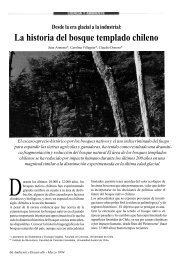

Create successful ePaper yourself
Turn your PDF publications into a flip-book with our unique Google optimized e-Paper software.
Veth / <strong>Desert</strong> <strong>People</strong>s Final Pro<strong>of</strong> 19.10.2004 12:00pm page 246Santoro,Arriaza,Standen,Marquetvaried ecological and archaeological data to discuss <strong>the</strong> principal issues <strong>of</strong> <strong>the</strong>natural and cultural history <strong>of</strong> <strong>the</strong> region, from <strong>the</strong> late Pleistocene to <strong>the</strong> lateHolocene (ca. 12,000–4,000 bp).The Ecological Setting <strong>of</strong> <strong>the</strong> <strong>Atacama</strong> <strong>Desert</strong>The <strong>Atacama</strong>/Peruvian <strong>Coastal</strong> <strong>Desert</strong> is one <strong>of</strong> <strong>the</strong> driest places on earth. Hyperaridityhas been present in <strong>the</strong> central <strong>Atacama</strong> for at least <strong>the</strong> last 15 million years,although recent studies have documented environmental changes (Betancourt et al.2000; Grosjean and Núñez 1994; Latorre et al. 2002). These paleoecological changesgreatly affected <strong>the</strong> distribution <strong>of</strong> animals and plants as well as that <strong>of</strong> past humanpopulations in this region. This desertic landscape, located on <strong>the</strong> west coast <strong>of</strong>South America, extends for more than 3,000 km along a narrow strip from nor<strong>the</strong>rnPeru (Lat. 58S) to nor<strong>the</strong>rn Chile (Lat. 278S). It owes its existence to <strong>the</strong> drying effect<strong>of</strong> <strong>the</strong> cold northward flowing Humboldt Current, <strong>the</strong> existence <strong>of</strong> air massesassociated with <strong>the</strong> sub-tropical high known as <strong>the</strong> South Pacific Anticyclone, andto <strong>the</strong> rain-shadow effect <strong>of</strong> <strong>the</strong> Andean mountain ranges, which impedes <strong>the</strong>penetration <strong>of</strong> moisture carried by <strong>the</strong> eastern trade winds. Although this desert iscontinuous from Peru to Chile, it is usually broken into two main components.The Peruvian <strong>Coastal</strong> <strong>Desert</strong> extends from Tumbes (ca. 58S) to Tacna in sou<strong>the</strong>rnPeru (ca. 188S), and <strong>the</strong> <strong>Atacama</strong> <strong>Desert</strong> from <strong>the</strong> area <strong>of</strong> Arica in nor<strong>the</strong>rn Chile(ca. 188S) to Copiapó (ca. 278S) (Marquet et al. 2002; Rauh 1985).The nor<strong>the</strong>rn part <strong>of</strong> <strong>the</strong> Peruvian <strong>Coastal</strong> <strong>Desert</strong> consists <strong>of</strong> a wide coastal plainwith shifting sands known as <strong>the</strong> Sechura <strong>Desert</strong>, some 100–150 km wide. During<strong>the</strong> terminal Pleistocene and Holocene this coastal desert provided more favorableliving conditions in <strong>the</strong> form <strong>of</strong> spring water and shallow lagoons with fresh water,as documented in Pampa de los Fósiles in <strong>the</strong> Cupisnique <strong>Desert</strong>, <strong>of</strong> nor<strong>the</strong>rn Peru.Fur<strong>the</strong>r south in <strong>the</strong> Peruvian <strong>Coastal</strong> <strong>Desert</strong>, thick cloudbanks form over <strong>the</strong>desert lands as a result <strong>of</strong> <strong>the</strong> cooling effect <strong>of</strong> <strong>the</strong> Humboldt Current, as similarlyoccurs with <strong>the</strong> cold Bengela Current in <strong>the</strong> Namib <strong>Desert</strong>. When intercepted byisolated mountains or steep coastal slopes, this cool moist air gives rise to a fogzone known as garúa in Peru and camanchaca in Chile. This moisture allows for<strong>the</strong> development <strong>of</strong> isolated and diverse vegetation formations called lomas (smallhills), where plants are adapted to condense this humidity. The lomas, comprisingcommunities <strong>of</strong> annual and perennial plants (Herbaceae and Gramineae) and cacti(Dillon 1997; Rauh 1985), grow vigorously during a short period in <strong>the</strong> winter <strong>of</strong><strong>the</strong> Sou<strong>the</strong>rn Hemisphere, and attract a wide variety <strong>of</strong> animals and birds (camelids,rodents, foxes). These ephemeral ‘‘fog oases’’ (Lavallée 2000) were occupiedseasonally by hunter-ga<strong>the</strong>rers whose base camps were located on <strong>the</strong> nearby coast(Benfer 1999; Quilter 1991).The <strong>Atacama</strong> <strong>Desert</strong>, located between 188S and 278S, can be divided in threesections: north, central, and south (see Figure 13.1). The latter, being <strong>the</strong> driest, hasnegligible archaeological data and thus is not described herein. Flanked to <strong>the</strong> eastby <strong>the</strong> high <strong>Coastal</strong> Cordillera, <strong>the</strong> littoral <strong>of</strong>fers discrete bays and beaches for_ 246_