You also want an ePaper? Increase the reach of your titles
YUMPU automatically turns print PDFs into web optimized ePapers that Google loves.
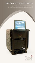
AeroGravProcessing SoftwareThe AeroGrav Data Processing softwareis designed to be used in the field to quicklyprocess data after each survey flight.The raw field data from the survey aircraft and ground GPS basestation can be quickly processed to produce the free-air and Bougergravity anomalies along survey lines. The processed data can beexported to mapping packages such as Geosoft Oasis Montaj or theGeneric Mapping Tools (GMT) for such tasks as survey line leveling,gridding and mapping. With rapid data turnaround, possibledata quality issues or system problems can be identified andoperation issues are dealt with in a timely fashion.