Management Plan - National Estuarine Research Reserve System
Management Plan - National Estuarine Research Reserve System
Management Plan - National Estuarine Research Reserve System

Create successful ePaper yourself
Turn your PDF publications into a flip-book with our unique Google optimized e-Paper software.
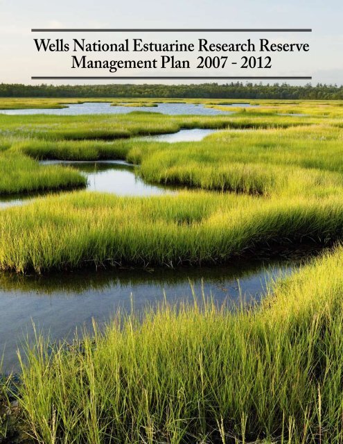
Wells <strong>National</strong> <strong>Estuarine</strong> <strong>Research</strong> <strong>Reserve</strong><strong>Management</strong> <strong>Plan</strong> 2007 - 2012
AcknowledgmentsThis document was prepared and printed with funds from Grant Award Number NA04NOS4200098,<strong>Estuarine</strong> <strong>Reserve</strong>s Division, Office of Ocean and Coastal Resource <strong>Management</strong> (OCRM), <strong>National</strong> OceanService (NOS) of the <strong>National</strong> Oceanic and Atmospheric Administration (NOAA), U.S. Department ofCommerce. Additional funds provided by Laudholm Trust.The Wells <strong>National</strong> <strong>Estuarine</strong> <strong>Research</strong> <strong>Reserve</strong> <strong>Management</strong> <strong>Plan</strong> was prepared by the staff of the Wells<strong>Reserve</strong> with input from its Advisory Committees—including those for Buildings, Education, Stewardship,and <strong>Research</strong>—and the members of the <strong>Reserve</strong> <strong>Management</strong> Authority. Guidance from NOAA wasprovided by Program Officer Doris Grimm of the <strong>Estuarine</strong> <strong>Reserve</strong>s Division. The principal contributorsincluded: Chris Feurt, Coastal Training Program Coordinator; Laura Lubelczyk, Education Coordinator(2006); Sarah Jolly, Education Coordinator; Tin Smith, Stewardship Coordinator; Michele Dionne,<strong>Research</strong> Coordinator; Nancy Viehmann, Volunteer Coordinator; Scott Richardson, CommunicationsCoordinator; Sue Bickford, Natural Resource Specialist; Cayce Dalton, <strong>Research</strong> and Education Associate(graphic design); Matthew McBride, GIS Specialist; and Paul Dest, <strong>Reserve</strong> Manager (editor).
Table of ContentsAcknowledgments.. . . . . . . . . . . . . . . . . . . . . . . . . . . . . . . . . . . . . . . . . . . . . . . . . . . . iiI. Overview .. . . . . . . . . . . . . . . . . . . . . . . . . . . . . . . . . . . . . . . . . . . . . . . . . . . . . . . . . . . 2Introduction to the <strong>Reserve</strong> .. . . . . . . . . . . . . . . . . . . . . . . . . . . . . . . . . . . . . . . . . . . . . . 2Part of a <strong>National</strong> <strong>System</strong> .. . . . . . . . . . . . . . . . . . . . . . . . . . . . . . . . . . . . . . . . . . . . . . . 2Purpose and Scope of the <strong>Plan</strong> .. . . . . . . . . . . . . . . . . . . . . . . . . . . . . . . . . . . . . . . . . . . . 2Education .. . . . . . . . . . . . . . . . . . . . . . . . . . . . . . . . . . . . . . . . . . . . . . . . . . . . . . . 3<strong>Research</strong> .. . . . . . . . . . . . . . . . . . . . . . . . . . . . . . . . . . . . . . . . . . . . . . . . . . . . . . . . 4Stewardship .. . . . . . . . . . . . . . . . . . . . . . . . . . . . . . . . . . . . . . . . . . . . . . . . . . . . . 4Boundary and Land Acquisition. . . . . . . . . . . . . . . . . . . . . . . . . . . . . . . . . . . 4Facilities .. . . . . . . . . . . . . . . . . . . . . . . . . . . . . . . . . . . . . . . . . . . . . . . . . . . . . . . . 5Administration .. . . . . . . . . . . . . . . . . . . . . . . . . . . . . . . . . . . . . . . . . . . . . . . . . . 6Volunteers. . . . . . . . . . . . . . . . . . . . . . . . . . . . . . . . . . . . . . . . . . . . . . . . . . . . . . . 6Site Profile .. . . . . . . . . . . . . . . . . . . . . . . . . . . . . . . . . . . . . . . . . . . . . . . . . . . . . . . . . . . 6II. Introduction. . . . . . . . . . . . . . . . . . . . . . . . . . . . . . . . . . . . . . . . . . . . . . . . . . . . . . . 8The Value of Estuaries .. . . . . . . . . . . . . . . . . . . . . . . . . . . . . . . . . . . . . . . . . . . . . . . . . . 8The NERR <strong>System</strong>.. . . . . . . . . . . . . . . . . . . . . . . . . . . . . . . . . . . . . . . . . . . . . . . . . . . . . 8Mission.. . . . . . . . . . . . . . . . . . . . . . . . . . . . . . . . . . . . . . . . . . . . . . . . . . . . . . . . . . 8Goals. . . . . . . . . . . . . . . . . . . . . . . . . . . . . . . . . . . . . . . . . . . . . . . . . . . . . . . . . . . . 9<strong>National</strong> <strong>Estuarine</strong> <strong>Research</strong> <strong>Reserve</strong> <strong>System</strong> Strategic Goals 2003 – 2008.. . . . 9<strong>Reserve</strong> <strong>System</strong> Strategic <strong>Plan</strong> Mission (revised 2006) .. . . . . . . . . . . . . . . . . . . . 9<strong>Reserve</strong> <strong>System</strong> Strategic <strong>Plan</strong> Goals (revised 2006).. . . . . . . . . . . . . . . . . . . . . . 9Biogeographic Regions. . . . . . . . . . . . . . . . . . . . . . . . . . . . . . . . . . . . . . . . . . . . 9<strong>Reserve</strong> Designation and Operation.. . . . . . . . . . . . . . . . . . . . . . . . . . . . . . 11NERRS Administrative Framework .. . . . . . . . . . . . . . . . . . . . . . . . . . . . . . 11<strong>Research</strong> and Monitoring <strong>Plan</strong> [§921.50].. . . . . . . . . . . . . . . . . . . . . . . . . . 11<strong>Reserve</strong> <strong>System</strong> <strong>Research</strong> Goals .. . . . . . . . . . . . . . . . . . . . . . . . . . . . . . . . . . . . . 11<strong>Reserve</strong> <strong>System</strong> <strong>Research</strong> Funding Priorities.. . . . . . . . . . . . . . . . . . . . . . . . . . . 12<strong>System</strong>-Wide Monitoring Program.. . . . . . . . . . . . . . . . . . . . . . . . . . . . . . . . . . 12Education <strong>Plan</strong> [§921.13(a)(4)]. . . . . . . . . . . . . . . . . . . . . . . . . . . . . . . . . . . . . 13<strong>Reserve</strong> <strong>System</strong> Education Mission and Goals.. . . . . . . . . . . . . . . . . . . . . . . . . . 14<strong>Reserve</strong> <strong>System</strong> Education Objectives .. . . . . . . . . . . . . . . . . . . . . . . . . . . . . . . . 14<strong>Reserve</strong> <strong>System</strong> Coastal Training Program.. . . . . . . . . . . . . . . . . . . . . . . . . . . . 14III. Wells NERR Setting. . . . . . . . . . . . . . . . . . . . . . . . . . . . . . . . . . . . . . . . . . . 18Physical Setting—Overview .. . . . . . . . . . . . . . . . . . . . . . . . . . . . . . . . . . . . . . . . . . . 18Geography.. . . . . . . . . . . . . . . . . . . . . . . . . . . . . . . . . . . . . . . . . . . . . . . . . . . . . . 18Geology .. . . . . . . . . . . . . . . . . . . . . . . . . . . . . . . . . . . . . . . . . . . . . . . . . . . . . . . . 19Hydrology.. . . . . . . . . . . . . . . . . . . . . . . . . . . . . . . . . . . . . . . . . . . . . . . . . . . . . . 19Climate. . . . . . . . . . . . . . . . . . . . . . . . . . . . . . . . . . . . . . . . . . . . . . . . . . . . . . . . . 20Vegetation and Habitats .. . . . . . . . . . . . . . . . . . . . . . . . . . . . . . . . . . . . . . . . 21Upland Fields and Forests.. . . . . . . . . . . . . . . . . . . . . . . . . . . . . . . . . . . . . . . . . 21Wetlands.. . . . . . . . . . . . . . . . . . . . . . . . . . . . . . . . . . . . . . . . . . . . . . . . . . . . . . 21Beach and Dune .. . . . . . . . . . . . . . . . . . . . . . . . . . . . . . . . . . . . . . . . . . . . . . . . 22Table of Contentsiii
Intertidal.. . . . . . . . . . . . . . . . . . . . . . . . . . . . . . . . . . . . . . . . . . . . . . . . . . . . . . 22Key Species. . . . . . . . . . . . . . . . . . . . . . . . . . . . . . . . . . . . . . . . . . . . . . . . . . . . . . 22Flora.. . . . . . . . . . . . . . . . . . . . . . . . . . . . . . . . . . . . . . . . . . . . . . . . . . . . . . . . . 22Invertebrate Fauna.. . . . . . . . . . . . . . . . . . . . . . . . . . . . . . . . . . . . . . . . . . . . . . 23Vertebrate Fauna.. . . . . . . . . . . . . . . . . . . . . . . . . . . . . . . . . . . . . . . . . . . . . . . . 23Cultural History and Community Setting .. . . . . . . . . . . . . . . . . . . . . . . . . . . . . . . . . 24History.. . . . . . . . . . . . . . . . . . . . . . . . . . . . . . . . . . . . . . . . . . . . . . . . . . . . . . . . . 24Community Growth and Land Use .. . . . . . . . . . . . . . . . . . . . . . . . . . . . . . . 25Population Growth.. . . . . . . . . . . . . . . . . . . . . . . . . . . . . . . . . . . . . . . . . . . . . . 26Land-Use <strong>Plan</strong>ning. . . . . . . . . . . . . . . . . . . . . . . . . . . . . . . . . . . . . . . . . . . . . . 26Marine-Related Activities. . . . . . . . . . . . . . . . . . . . . . . . . . . . . . . . . . . . . . . . . 26Tourism and Travel.. . . . . . . . . . . . . . . . . . . . . . . . . . . . . . . . . . . . . . . . . . . . . . 26Water Quality.. . . . . . . . . . . . . . . . . . . . . . . . . . . . . . . . . . . . . . . . . . . . . . . . . . 26Impacts Affecting the <strong>Reserve</strong>.. . . . . . . . . . . . . . . . . . . . . . . . . . . . . . . . . . . 26IV. Strategic <strong>Plan</strong> 2007 - 2012 .. . . . . . . . . . . . . . . . . . . . . . . . . . . . . . . . . . . . . 30Vision .. . . . . . . . . . . . . . . . . . . . . . . . . . . . . . . . . . . . . . . . . . . . . . . . . . . . . . . . . . . . . . 30Mission.. . . . . . . . . . . . . . . . . . . . . . . . . . . . . . . . . . . . . . . . . . . . . . . . . . . . . . . . . . . . . 30Strategic Goals.. . . . . . . . . . . . . . . . . . . . . . . . . . . . . . . . . . . . . . . . . . . . . . . . . . . . . . . 30Strategic Objectives.. . . . . . . . . . . . . . . . . . . . . . . . . . . . . . . . . . . . . . . . . . . . . . . . . . . 30Education .. . . . . . . . . . . . . . . . . . . . . . . . . . . . . . . . . . . . . . . . . . . . . . . . . . . . . . 30<strong>Research</strong> .. . . . . . . . . . . . . . . . . . . . . . . . . . . . . . . . . . . . . . . . . . . . . . . . . . . . . . . 31Stewardship .. . . . . . . . . . . . . . . . . . . . . . . . . . . . . . . . . . . . . . . . . . . . . . . . . . . . 31Administration .. . . . . . . . . . . . . . . . . . . . . . . . . . . . . . . . . . . . . . . . . . . . . . . . . 31Boundary and Acquisition .. . . . . . . . . . . . . . . . . . . . . . . . . . . . . . . . . . . . . . . 31Facilities .. . . . . . . . . . . . . . . . . . . . . . . . . . . . . . . . . . . . . . . . . . . . . . . . . . . . . . . 31Public Access .. . . . . . . . . . . . . . . . . . . . . . . . . . . . . . . . . . . . . . . . . . . . . . . . . . . 31Communications. . . . . . . . . . . . . . . . . . . . . . . . . . . . . . . . . . . . . . . . . . . . . . . . . 31Volunteers. . . . . . . . . . . . . . . . . . . . . . . . . . . . . . . . . . . . . . . . . . . . . . . . . . . . . . 31V. Accomplishments 2000 - 2006.. . . . . . . . . . . . . . . . . . . . . . . . . . . . . . . . . . 34Facilities, Exhibits and Trails.. . . . . . . . . . . . . . . . . . . . . . . . . . . . . . . . . . . . . . . . . . . 34Interpretive Education. . . . . . . . . . . . . . . . . . . . . . . . . . . . . . . . . . . . . . . . . . . . . . . . . 34Coastal Training Program.. . . . . . . . . . . . . . . . . . . . . . . . . . . . . . . . . . . . . . . . . . . . . . 35<strong>Research</strong> .. . . . . . . . . . . . . . . . . . . . . . . . . . . . . . . . . . . . . . . . . . . . . . . . . . . . . . . . . . . . 36Stewardship .. . . . . . . . . . . . . . . . . . . . . . . . . . . . . . . . . . . . . . . . . . . . . . . . . . . . . . . . . 38Public Information.. . . . . . . . . . . . . . . . . . . . . . . . . . . . . . . . . . . . . . . . . . . . . . . . . . . . 40Partnerships and Community Engagement .. . . . . . . . . . . . . . . . . . . . . . . . . . . . . . . . 40Volunteer Programs .. . . . . . . . . . . . . . . . . . . . . . . . . . . . . . . . . . . . . . . . . . . . . . . . . . . 40<strong>Plan</strong>ning Documents .. . . . . . . . . . . . . . . . . . . . . . . . . . . . . . . . . . . . . . . . . . . . . . . . . . 40VI. Administrative <strong>Plan</strong>.. . . . . . . . . . . . . . . . . . . . . . . . . . . . . . . . . . . . . . . . . . . . 42Introduction .. . . . . . . . . . . . . . . . . . . . . . . . . . . . . . . . . . . . . . . . . . . . . . . . . . . . . . . . . 42Objective and Strategies .. . . . . . . . . . . . . . . . . . . . . . . . . . . . . . . . . . . . . . . . . . . . . . . 42Objective.. . . . . . . . . . . . . . . . . . . . . . . . . . . . . . . . . . . . . . . . . . . . . . . . . . . . . . . 42Strategies .. . . . . . . . . . . . . . . . . . . . . . . . . . . . . . . . . . . . . . . . . . . . . . . . . . . . . . 42Administrative Structure: <strong>Reserve</strong> <strong>Management</strong> Authority.. . . . . . . . . . . . . . . . . . . 42ivWells <strong>National</strong> <strong>Estuarine</strong> <strong>Research</strong> <strong>Reserve</strong>
Representation on the <strong>Reserve</strong> <strong>Management</strong> Authority. . . . . . . . . . . 42Maine Department of Conservation.. . . . . . . . . . . . . . . . . . . . . . . . . . . . . . . . . 43U.S. Department of the Interior, Fish and Wildlife Service. . . . . . . . . . . . . . . . 43Town of Wells .. . . . . . . . . . . . . . . . . . . . . . . . . . . . . . . . . . . . . . . . . . . . . . . . . . 43Laudholm Trust. . . . . . . . . . . . . . . . . . . . . . . . . . . . . . . . . . . . . . . . . . . . . . . . . .43Maine State <strong>Plan</strong>ning Office/Maine Coastal Program.. . . . . . . . . . . . . . . . . . . 43U.S. Department of Commerce, NOAA .. . . . . . . . . . . . . . . . . . . . . . . . . . . . . . 43Interagency Memoranda of Understanding.. . . . . . . . . . . . . . . . . . . . . . . . . . . . 43Other Partner Roles and Responsibilities .. . . . . . . . . . . . . . . . . . . . . . . . . . . . . 44NOAA’s Roles and Responsibilities. . . . . . . . . . . . . . . . . . . . . . . . . . . . . . . . . . . . . . . 45Laudholm Trust Partnership. . . . . . . . . . . . . . . . . . . . . . . . . . . . . . . . . . . . . . . . . . . . 45<strong>National</strong> Historic Preservation Act. . . . . . . . . . . . . . . . . . . . . . . . . . . . . . . . . . . . . . . 46Maine Coastal Program and Maine Sea Grant College Program.. . . . . . . . . . . . . . . 46<strong>Reserve</strong> Staff Responsibilities.. . . . . . . . . . . . . . . . . . . . . . . . . . . . . . . . . . . . . . . . . . . 46In-Kind Staff Roles and Responsibilities .. . . . . . . . . . . . . . . . . . . . . . . . . 47Volunteer Roles and Responsibilities. . . . . . . . . . . . . . . . . . . . . . . . . . . . . 47Wells <strong>Reserve</strong> Advisory Committees.. . . . . . . . . . . . . . . . . . . . . . . . . . . . . . . . . . . . . . 48Wells <strong>Reserve</strong> Program Integration Strategy.. . . . . . . . . . . . . . . . . . . . . . . . . . . . . . . 48VII. Facilities and Construction <strong>Plan</strong>. . . . . . . . . . . . . . . . . . . . . . . . . . . . . 52Introduction .. . . . . . . . . . . . . . . . . . . . . . . . . . . . . . . . . . . . . . . . . . . . . . . . . . . . . . . . . 52Objective and Strategies .. . . . . . . . . . . . . . . . . . . . . . . . . . . . . . . . . . . . . . . . . . . . . . . 52Objective.. . . . . . . . . . . . . . . . . . . . . . . . . . . . . . . . . . . . . . . . . . . . . . . . . . . . . . . 52Strategies .. . . . . . . . . . . . . . . . . . . . . . . . . . . . . . . . . . . . . . . . . . . . . . . . . . . . . . 52Laudholm Farm: Main Campus Facilities and Forest Learning Shelter .. . . . . . . . . 53Main Farmhouse (includes ell and woodshed).. . . . . . . . . . . . . . . . . . . . . 53Barn Complex (includes auditorium and library).. . . . . . . . . . . . . . . . . . 54Maine Coastal Ecology Center (MCEC) .. . . . . . . . . . . . . . . . . . . . . . . . . 54Ice House .. . . . . . . . . . . . . . . . . . . . . . . . . . . . . . . . . . . . . . . . . . . . . . . . . . . . . . . 54Water Tower. . . . . . . . . . . . . . . . . . . . . . . . . . . . . . . . . . . . . . . . . . . . . . . . . . . . 54Gazebo/Well House.. . . . . . . . . . . . . . . . . . . . . . . . . . . . . . . . . . . . . . . . . . . . . 55Forest Learning Shelter .. . . . . . . . . . . . . . . . . . . . . . . . . . . . . . . . . . . . . . . . 55Laudholm Farm: <strong>Reserve</strong>d Life Estate Buildings .. . . . . . . . . . . . . . . . . . . . . . . . . . . 55Manure Shed (circa 1905).. . . . . . . . . . . . . . . . . . . . . . . . . . . . . . . . . . . . . . . . . 56Sheep Barn (circa 1890-1900) .. . . . . . . . . . . . . . . . . . . . . . . . . . . . . . . . . . . . . . 56Farmer’s Cottage and Wood Shed (circa 1830-1850) .. . . . . . . . . . . . . . . . . 56Killing House (early 1900’s) .. . . . . . . . . . . . . . . . . . . . . . . . . . . . . . . . . . . . . . 57Chick Brooder Building / Little Residence (circa 1916).. . . . . . . . . . . . . 57Bull Barn and Silo (early 1900’s) .. . . . . . . . . . . . . . . . . . . . . . . . . . . . . . . . . 57Auto Garages (1907/1920’s).. . . . . . . . . . . . . . . . . . . . . . . . . . . . . . . . . . . . . . . . 57Brooder House.. . . . . . . . . . . . . . . . . . . . . . . . . . . . . . . . . . . . . . . . . . . . . . . . . . 57Other Buildings .. . . . . . . . . . . . . . . . . . . . . . . . . . . . . . . . . . . . . . . . . . . . . . . . 57Facilities of the Alheim Property. . . . . . . . . . . . . . . . . . . . . . . . . . . . . . . . 58Alheim Commons (2006).. . . . . . . . . . . . . . . . . . . . . . . . . . . . . . . . . . . . . . . . . . . . . . . 58Alheim Commons Studio (circa 1900) .. . . . . . . . . . . . . . . . . . . . . . . . . . . . . . 58Ranch-style House (circa 1960’s). . . . . . . . . . . . . . . . . . . . . . . . . . . . . . . . . . . 58Table of Contents
In-holding Properties and Renovation of Buildings. . . . . . . . . . . . . . . . . . . . . . . . . . 5819 th Century Lord Farmhouse.. . . . . . . . . . . . . . . . . . . . . . . . . . . . . . . . . . . . 59VIII. Public Access <strong>Plan</strong> .. . . . . . . . . . . . . . . . . . . . . . . . . . . . . . . . . . . . . . . . . . . 62Introduction .. . . . . . . . . . . . . . . . . . . . . . . . . . . . . . . . . . . . . . . . . . . . . . . . . . . . . . . . . 62Objective and Strategies .. . . . . . . . . . . . . . . . . . . . . . . . . . . . . . . . . . . . . . . . . . . . . . . 62Objective.. . . . . . . . . . . . . . . . . . . . . . . . . . . . . . . . . . . . . . . . . . . . . . . . . . . . . . . 62Strategies .. . . . . . . . . . . . . . . . . . . . . . . . . . . . . . . . . . . . . . . . . . . . . . . . . . . . . . 62Audiences, Hours of Operation and Fees.. . . . . . . . . . . . . . . . . . . . . . . . . . . . . . . . . . . 62Trail Hours.. . . . . . . . . . . . . . . . . . . . . . . . . . . . . . . . . . . . . . . . . . . . . . . . . . . . . 63Fees .. . . . . . . . . . . . . . . . . . . . . . . . . . . . . . . . . . . . . . . . . . . . . . . . . . . . . . . . . . . . 63Points of Access to the <strong>Reserve</strong>.. . . . . . . . . . . . . . . . . . . . . . . . . . . . . . . . . . . . . . . . . . . 63Permitted Activities — Lands. . . . . . . . . . . . . . . . . . . . . . . . . . . . . . . . . . . . . . . . . . . 64Permitted Activities — Facilities .. . . . . . . . . . . . . . . . . . . . . . . . . . . . . . . . . . . . . . . . 65Wildlife Sanctuary Designation .. . . . . . . . . . . . . . . . . . . . . . . . . . . . . . . . . . . . . . . . . 65Rules and Regulations.. . . . . . . . . . . . . . . . . . . . . . . . . . . . . . . . . . . . . . . . . . . . . . . . . 66IX. Education and Outreach <strong>Plan</strong>.. . . . . . . . . . . . . . . . . . . . . . . . . . . . . . . . . 68Introduction .. . . . . . . . . . . . . . . . . . . . . . . . . . . . . . . . . . . . . . . . . . . . . . . . . . . . . . . . . 68Objectives and Strategies.. . . . . . . . . . . . . . . . . . . . . . . . . . . . . . . . . . . . . . . . . . . . . . . 68Objective 1. . . . . . . . . . . . . . . . . . . . . . . . . . . . . . . . . . . . . . . . . . . . . . . . . . . . . . 68Strategies .. . . . . . . . . . . . . . . . . . . . . . . . . . . . . . . . . . . . . . . . . . . . . . . . . . . . . . 68Objective 2. . . . . . . . . . . . . . . . . . . . . . . . . . . . . . . . . . . . . . . . . . . . . . . . . . . . . . 68Strategies .. . . . . . . . . . . . . . . . . . . . . . . . . . . . . . . . . . . . . . . . . . . . . . . . . . . . . . 68Objective 3. . . . . . . . . . . . . . . . . . . . . . . . . . . . . . . . . . . . . . . . . . . . . . . . . . . . . . 68Strategies .. . . . . . . . . . . . . . . . . . . . . . . . . . . . . . . . . . . . . . . . . . . . . . . . . . . . . . 69Objective 4. . . . . . . . . . . . . . . . . . . . . . . . . . . . . . . . . . . . . . . . . . . . . . . . . . . . . . 69Strategies .. . . . . . . . . . . . . . . . . . . . . . . . . . . . . . . . . . . . . . . . . . . . . . . . . . . . . . 69Guiding Principles.. . . . . . . . . . . . . . . . . . . . . . . . . . . . . . . . . . . . . . . . . . . . . . . . . . . . 69Geographic Scope .. . . . . . . . . . . . . . . . . . . . . . . . . . . . . . . . . . . . . . . . . . . . . . . . . . . . . 69Coastal Training Program.. . . . . . . . . . . . . . . . . . . . . . . . . . . . . . . . . . . . . . . . . . . . . . 70K–12 Education.. . . . . . . . . . . . . . . . . . . . . . . . . . . . . . . . . . . . . . . . . . . . . . . . . . . . . . 71Field-and-Lab School Programs .. . . . . . . . . . . . . . . . . . . . . . . . . . . . . . . . . 71Field-Based School Programs.. . . . . . . . . . . . . . . . . . . . . . . . . . . . . . . . . . . . 72Day Camps .. . . . . . . . . . . . . . . . . . . . . . . . . . . . . . . . . . . . . . . . . . . . . . . . . . . . . . 72Teacher/Educator Training .. . . . . . . . . . . . . . . . . . . . . . . . . . . . . . . . . . . . . 72Docent Naturalist Training.. . . . . . . . . . . . . . . . . . . . . . . . . . . . . . . . . . . . . . . . . . . . . 73Public Programs.. . . . . . . . . . . . . . . . . . . . . . . . . . . . . . . . . . . . . . . . . . . . . . . . . . . . . . 73Exhibits. . . . . . . . . . . . . . . . . . . . . . . . . . . . . . . . . . . . . . . . . . . . . . . . . . . . . . . . . . . . . 75Trail/Site Interpretation.. . . . . . . . . . . . . . . . . . . . . . . . . . . . . . . . . . . . . . . . . . . . . . . 75Higher Education (including internships and mentorships).. . . . . . . . 75Off-site Programs and Community Outreach .. . . . . . . . . . . . . . . . . . . . . . . . . . . . . . 75Citizen Monitoring.. . . . . . . . . . . . . . . . . . . . . . . . . . . . . . . . . . . . . . . . . . . . . . . . . . . 75Coastal Resource Library.. . . . . . . . . . . . . . . . . . . . . . . . . . . . . . . . . . . . . . . . . . . . . . . 76X. <strong>Research</strong> and Monitoring <strong>Plan</strong>.. . . . . . . . . . . . . . . . . . . . . . . . . . . . . . . . . 78Introduction .. . . . . . . . . . . . . . . . . . . . . . . . . . . . . . . . . . . . . . . . . . . . . . . . . . . . . . . . . 78viWells <strong>National</strong> <strong>Estuarine</strong> <strong>Research</strong> <strong>Reserve</strong>
Objectives and Strategies.. . . . . . . . . . . . . . . . . . . . . . . . . . . . . . . . . . . . . . . . . . . . . . . 78Objective 1. . . . . . . . . . . . . . . . . . . . . . . . . . . . . . . . . . . . . . . . . . . . . . . . . . . . . . 78Strategies .. . . . . . . . . . . . . . . . . . . . . . . . . . . . . . . . . . . . . . . . . . . . . . . . . . . . . . 78Objective 2. . . . . . . . . . . . . . . . . . . . . . . . . . . . . . . . . . . . . . . . . . . . . . . . . . . . . . 78Strategies .. . . . . . . . . . . . . . . . . . . . . . . . . . . . . . . . . . . . . . . . . . . . . . . . . . . . . . 78Objective 3. . . . . . . . . . . . . . . . . . . . . . . . . . . . . . . . . . . . . . . . . . . . . . . . . . . . . . 79Strategies .. . . . . . . . . . . . . . . . . . . . . . . . . . . . . . . . . . . . . . . . . . . . . . . . . . . . . . 79NERR <strong>System</strong> <strong>Research</strong> Overview .. . . . . . . . . . . . . . . . . . . . . . . . . . . . . . . . . . . . . . 79<strong>System</strong>-wide <strong>Research</strong> Funding Priorities.. . . . . . . . . . . . . . . . . . . . . . . . . . . . . . . . . 80Graduate <strong>Research</strong> Fellowships .. . . . . . . . . . . . . . . . . . . . . . . . . . . . . . . . . 80<strong>System</strong>-wide Phased Monitoring .. . . . . . . . . . . . . . . . . . . . . . . . . . . . . . . . . 80<strong>System</strong>-wide Monitoring Program. . . . . . . . . . . . . . . . . . . . . . . . . . . . . . . . 81Abiotic Variables .. . . . . . . . . . . . . . . . . . . . . . . . . . . . . . . . . . . . . . . . . . . . . . . . 81Biological Monitoring.. . . . . . . . . . . . . . . . . . . . . . . . . . . . . . . . . . . . . . . . . . . . 81Land Use and Habitat Change.. . . . . . . . . . . . . . . . . . . . . . . . . . . . . . . . . . . . . 81Wells <strong>Reserve</strong> <strong>Research</strong> Themes.. . . . . . . . . . . . . . . . . . . . . . . . . . . . . . . . . . . . . . . . . . 82<strong>Estuarine</strong> Water Quality. . . . . . . . . . . . . . . . . . . . . . . . . . . . . . . . . . . . . . . . 82Salt Marsh Habitats and Communities. . . . . . . . . . . . . . . . . . . . . . . . . . . 82Habitat Value for Fish, Shellfish and Birds.. . . . . . . . . . . . . . . . . . . . . . 83Salt Marsh Degradation and Restoration .. . . . . . . . . . . . . . . . . . . . . . . 83Field <strong>Research</strong> Sites .. . . . . . . . . . . . . . . . . . . . . . . . . . . . . . . . . . . . . . . . . . . . 83Academic and Institutional Partnerships.. . . . . . . . . . . . . . . . . . . . . . . . . . . . . . . . . . 83Government Partnerships.. . . . . . . . . . . . . . . . . . . . . . . . . . . . . . . . . . . . . . . . . . . . . . 84Mentoring and Internships .. . . . . . . . . . . . . . . . . . . . . . . . . . . . . . . . . . . . . . . . . . . . . 85Information Dissemination.. . . . . . . . . . . . . . . . . . . . . . . . . . . . . . . . . . . . . . . . . . . . . 85Conferences and Workshops.. . . . . . . . . . . . . . . . . . . . . . . . . . . . . . . . . . . . . 85Site Profile.. . . . . . . . . . . . . . . . . . . . . . . . . . . . . . . . . . . . . . . . . . . . . . . . . . . . . 85XI. Stewardship <strong>Plan</strong> .. . . . . . . . . . . . . . . . . . . . . . . . . . . . . . . . . . . . . . . . . . . . . . . 88Introduction .. . . . . . . . . . . . . . . . . . . . . . . . . . . . . . . . . . . . . . . . . . . . . . . . . . . . . . . . . 88Goals and Objectives .. . . . . . . . . . . . . . . . . . . . . . . . . . . . . . . . . . . . . . . . . . . . . . . . . . 88Objective 1. . . . . . . . . . . . . . . . . . . . . . . . . . . . . . . . . . . . . . . . . . . . . . . . . . . . . . 88Strategies .. . . . . . . . . . . . . . . . . . . . . . . . . . . . . . . . . . . . . . . . . . . . . . . . . . . . . . 88Objective 2. . . . . . . . . . . . . . . . . . . . . . . . . . . . . . . . . . . . . . . . . . . . . . . . . . . . . . 89Strategies .. . . . . . . . . . . . . . . . . . . . . . . . . . . . . . . . . . . . . . . . . . . . . . . . . . . . . . 89Objective 3. . . . . . . . . . . . . . . . . . . . . . . . . . . . . . . . . . . . . . . . . . . . . . . . . . . . . . 89Strategies .. . . . . . . . . . . . . . . . . . . . . . . . . . . . . . . . . . . . . . . . . . . . . . . . . . . . . . 89Objective 4. . . . . . . . . . . . . . . . . . . . . . . . . . . . . . . . . . . . . . . . . . . . . . . . . . . . . . 89Strategies .. . . . . . . . . . . . . . . . . . . . . . . . . . . . . . . . . . . . . . . . . . . . . . . . . . . . . . 89Site-Based Stewardship.. . . . . . . . . . . . . . . . . . . . . . . . . . . . . . . . . . . . . . . . . . . . . . . . 89<strong>Management</strong> Framework .. . . . . . . . . . . . . . . . . . . . . . . . . . . . . . . . . . . . . . . . 89Environmental and Public Safety Laws .. . . . . . . . . . . . . . . . . . . . . . . . . . 90<strong>Management</strong> Zones. . . . . . . . . . . . . . . . . . . . . . . . . . . . . . . . . . . . . . . . . . . . . . 91Public and Administrative Zone.. . . . . . . . . . . . . . . . . . . . . . . . . . . . . . . . . . . . 91Active <strong>Management</strong> Zone.. . . . . . . . . . . . . . . . . . . . . . . . . . . . . . . . . . . . . . . . . 91Conservation Zone .. . . . . . . . . . . . . . . . . . . . . . . . . . . . . . . . . . . . . . . . . . . . . . 92Table of Contentsvii
Protected Zone.. . . . . . . . . . . . . . . . . . . . . . . . . . . . . . . . . . . . . . . . . . . . . . . . . . 92Resource <strong>Management</strong> Projects.. . . . . . . . . . . . . . . . . . . . . . . . . . . . . . . . . . 92Deer Population Control.. . . . . . . . . . . . . . . . . . . . . . . . . . . . . . . . . . . . . . . . . . 92Invasive <strong>Plan</strong>t Control.. . . . . . . . . . . . . . . . . . . . . . . . . . . . . . . . . . . . . . . . . . . 92New England Cottontail Habitat <strong>Management</strong>.. . . . . . . . . . . . . . . . . . . . . . . . 93Open Field <strong>Management</strong>. . . . . . . . . . . . . . . . . . . . . . . . . . . . . . . . . . . . . . . . . . 93Drakes Island Restoration Monitoring .. . . . . . . . . . . . . . . . . . . . . . . . . . . . . . . 93Potential Restoration Projects .. . . . . . . . . . . . . . . . . . . . . . . . . . . . . . . . . 93Harbor Park .. . . . . . . . . . . . . . . . . . . . . . . . . . . . . . . . . . . . . . . . . . . . . . . . . . . 94Beaches and Dunes .. . . . . . . . . . . . . . . . . . . . . . . . . . . . . . . . . . . . . . . . . . . . . . 94Wells Harbor.. . . . . . . . . . . . . . . . . . . . . . . . . . . . . . . . . . . . . . . . . . . . . . . . . . . 94Community-Based Stewardship.. . . . . . . . . . . . . . . . . . . . . . . . . . . . . . . . . . . . . . . . . 95Watershed Protection .. . . . . . . . . . . . . . . . . . . . . . . . . . . . . . . . . . . . . . . . . . 95Land Conservation and GIS Center .. . . . . . . . . . . . . . . . . . . . . . . . . . . . . . 95Habitat Restoration.. . . . . . . . . . . . . . . . . . . . . . . . . . . . . . . . . . . . . . . . . . . . 96XII. <strong>Reserve</strong> Boundary and Acquisition <strong>Plan</strong>.. . . . . . . . . . . . . . . . . . . . 98Introduction .. . . . . . . . . . . . . . . . . . . . . . . . . . . . . . . . . . . . . . . . . . . . . . . . . . . . . . . . . 98Objective and Strategies .. . . . . . . . . . . . . . . . . . . . . . . . . . . . . . . . . . . . . . . . . . . . . . . 98Objective.. . . . . . . . . . . . . . . . . . . . . . . . . . . . . . . . . . . . . . . . . . . . . . . . . . . . . . . 98Strategies .. . . . . . . . . . . . . . . . . . . . . . . . . . . . . . . . . . . . . . . . . . . . . . . . . . . . . . 98Proposed Changes to the <strong>Reserve</strong> and Acquisition Boundary (Section 315).. . . . . . . . 99Justification for Changes to the Boundary.. . . . . . . . . . . . . . . . . . . . . . . . . . . . . . . . . 100Ecology. . . . . . . . . . . . . . . . . . . . . . . . . . . . . . . . . . . . . . . . . . . . . . . . . . . . . . . . 102Maintain the Integrity of Coastal Watersheds .. . . . . . . . . . . . . . . . . 102Protecting Water Quality .. . . . . . . . . . . . . . . . . . . . . . . . . . . . . . . . . . . . . 102Habitat Protection.. . . . . . . . . . . . . . . . . . . . . . . . . . . . . . . . . . . . . . . . . . . . 102Education, Outreach, and Training.. . . . . . . . . . . . . . . . . . . . . . . . . . . . . 103<strong>Research</strong> and Monitoring .. . . . . . . . . . . . . . . . . . . . . . . . . . . . . . . . . . . . . . 103Evaluation Criteria.. . . . . . . . . . . . . . . . . . . . . . . . . . . . . . . . . . . . . . . . . . . . . . . . . . 104Priorities for Acquisition.. . . . . . . . . . . . . . . . . . . . . . . . . . . . . . . . . . . . . . . . . . . . . . 104Specific In-holdings and Adjacent Parcels.. . . . . . . . . . . . . . . . . . . . . . . 104Focus Areas on Little River and Webhannet River .. . . . . . . . . . . . . . 105Focus Area #1 — Little River Watershed .. . . . . . . . . . . . . . . . . . . . . . . . . . . . 105Focus Area #2 — Webhannet River Watershed.. . . . . . . . . . . . . . . . . . . . . . . . 106Note on Sections of Watersheds Outside Town of Wells.. . . . . . . . . 106Strategies and Methods for Acquisition. . . . . . . . . . . . . . . . . . . . . . . . . . . . . . . . . . . 106Evaluating Conservation Lands.. . . . . . . . . . . . . . . . . . . . . . . . . . . . . . . . . 106Means of Acquisition .. . . . . . . . . . . . . . . . . . . . . . . . . . . . . . . . . . . . . . . . . . . . . . . . . 106Approaches to Land Protection. . . . . . . . . . . . . . . . . . . . . . . . . . . . . . . . . 106Fee Simple Purchase .. . . . . . . . . . . . . . . . . . . . . . . . . . . . . . . . . . . . . . . . . . . . 106Conservation Easement. . . . . . . . . . . . . . . . . . . . . . . . . . . . . . . . . . . . . . . . . . 107Donations.. . . . . . . . . . . . . . . . . . . . . . . . . . . . . . . . . . . . . . . . . . . . . . . . . . . . 107Other Methods. . . . . . . . . . . . . . . . . . . . . . . . . . . . . . . . . . . . . . . . . . . . . . . . . 107Funds for Land Acquisition.. . . . . . . . . . . . . . . . . . . . . . . . . . . . . . . . . . . . . 107Holding Title to Acquired Lands.. . . . . . . . . . . . . . . . . . . . . . . . . . . . . . . 107viiiWells <strong>National</strong> <strong>Estuarine</strong> <strong>Research</strong> <strong>Reserve</strong>
XIII. Volunteer <strong>Plan</strong>.. . . . . . . . . . . . . . . . . . . . . . . . . . . . . . . . . . . . . . . . . . . . . . . 110Introduction .. . . . . . . . . . . . . . . . . . . . . . . . . . . . . . . . . . . . . . . . . . . . . . . . . . . . . . . . 110Objective and Strategies .. . . . . . . . . . . . . . . . . . . . . . . . . . . . . . . . . . . . . . . . . . . . . . 110Objective.. . . . . . . . . . . . . . . . . . . . . . . . . . . . . . . . . . . . . . . . . . . . . . . . . . . . . . 110Strategies .. . . . . . . . . . . . . . . . . . . . . . . . . . . . . . . . . . . . . . . . . . . . . . . . . . . . . 110Volunteers.. . . . . . . . . . . . . . . . . . . . . . . . . . . . . . . . . . . . . . . . . . . . . . . . . . . . . . . . . . 110Volunteer Positions.. . . . . . . . . . . . . . . . . . . . . . . . . . . . . . . . . . . . . . . . . . . . 110Volunteer Recruitment .. . . . . . . . . . . . . . . . . . . . . . . . . . . . . . . . . . . . . . . . 110Volunteer Training .. . . . . . . . . . . . . . . . . . . . . . . . . . . . . . . . . . . . . . . . . . . . . 111Evaluating Volunteers .. . . . . . . . . . . . . . . . . . . . . . . . . . . . . . . . . . . . . . . . . . 111Rewarding Volunteer Involvement.. . . . . . . . . . . . . . . . . . . . . . . . . . . . . . . 111XIV. Communications <strong>Plan</strong>.. . . . . . . . . . . . . . . . . . . . . . . . . . . . . . . . . . . . . . . 114Introduction .. . . . . . . . . . . . . . . . . . . . . . . . . . . . . . . . . . . . . . . . . . . . . . . . . . . . . . . . 114Objective and Strategies .. . . . . . . . . . . . . . . . . . . . . . . . . . . . . . . . . . . . . . . . . . . . . . 114Objective.. . . . . . . . . . . . . . . . . . . . . . . . . . . . . . . . . . . . . . . . . . . . . . . . . . . . . . 114Strategies .. . . . . . . . . . . . . . . . . . . . . . . . . . . . . . . . . . . . . . . . . . . . . . . . . . . . . 114Print Publications .. . . . . . . . . . . . . . . . . . . . . . . . . . . . . . . . . . . . . . . . . . . . . . . . . . . 114Electronic Communications.. . . . . . . . . . . . . . . . . . . . . . . . . . . . . . . . . . . . . . . . . . . . 114Media Relations.. . . . . . . . . . . . . . . . . . . . . . . . . . . . . . . . . . . . . . . . . . . . . . . . . . . . . 114Events, Presentations, and Displays.. . . . . . . . . . . . . . . . . . . . . . . . . . . . . . . . . . . . . . 115Tracking Success.. . . . . . . . . . . . . . . . . . . . . . . . . . . . . . . . . . . . . . . . . . . . . . . . . . . . . . 115Appendix A: Memoranda of Understanding.. . . . . . . . . . . . . . . . . . . . 120Appendix A.1: NOAA and RMA.. . . . . . . . . . . . . . . . . . . . . . . . . . . . . . . . . . . . . . . 120Appendix A.2: USFWS and RMA. . . . . . . . . . . . . . . . . . . . . . . . . . . . . . . . . . . . . . 124Appendix A.3: Maine Dept. Conservation/BPL and RMA - Laudholm Beach andUplands. . . . . . . . . . . . . . . . . . . . . . . . . . . . . . . . . . . . . . . . . . . . . . . . . . . . . . . . . . . . 128Appendix A.4: Maine Dept. Conservation/BPL and RMA - Submerged Lands.. 132Appendix A.5: Town of Wells and RMA.. . . . . . . . . . . . . . . . . . . . . . . . . . . . . . . . . 134Appendix A-6: Laudholm Trust and RMA.. . . . . . . . . . . . . . . . . . . . . . . . . . . . . . . 136Appendix B: Conservation Easements .. . . . . . . . . . . . . . . . . . . . . . . . . . 142Appendix B-1: Conservation Easement Deed on Laudholm Farm .. . . . . . . . . . . . 142Appendix B-2: Conservation Easement Deed at Wells Harbor. . . . . . . . . . . . . . . . 154Appendix C: State of Maine Legislation .. . . . . . . . . . . . . . . . . . . . . . . . 166Appendix C-1: Act to Establish Wells NERR .. . . . . . . . . . . . . . . . . . . . . . . . . . . . . 166Appendix C-2: Act to Amend the Laws Regarding the Location of Wells NERR... 172Appendix D: Rules for Public Use .. . . . . . . . . . . . . . . . . . . . . . . . . . . . . . . 176Appendix E: Natural Resource Laws.. . . . . . . . . . . . . . . . . . . . . . . . . . . . 184Appendix F: Federal Regulations—NERRS .. . . . . . . . . . . . . . . . . . . 194Appendix G: CZMA—Section 315.. . . . . . . . . . . . . . . . . . . . . . . . . . . . . . 222Appendix H: Wells NERR Acreage Comparisons.. . . . . . . . . . . . . 227Table of Contentsix
Wells <strong>National</strong> <strong>Estuarine</strong> <strong>Research</strong> <strong>Reserve</strong>
xiiWells <strong>National</strong> <strong>Estuarine</strong> <strong>Research</strong> <strong>Reserve</strong>
I. Overview
I. OverviewIntroduction to the <strong>Reserve</strong>The Wells <strong>National</strong> <strong>Estuarine</strong> <strong>Research</strong> <strong>Reserve</strong>was designated a <strong>National</strong> <strong>Estuarine</strong> <strong>Research</strong><strong>Reserve</strong> by the <strong>National</strong> Oceanic and AtmosphericAdministration (NOAA) in 1984.The Wells <strong>Reserve</strong> is the only NERR in Maine andone of two NERRs located in NOAA’s AcadianBiogeographic Region. It is situated on the southernMaine coast, and comprises 2,250 acres of saltmarshes, beaches, dunes, upland fields and forests,riparian areas and submerged lands within thewatersheds of the Little River, Webhannet River,and Ogunquit River. Parcels of conserved landowned by the U.S. Fish and Wildlife Service, Townof Wells, the Maine Department of Conservationand the Wells <strong>Reserve</strong> <strong>Management</strong> Authoritymake up the <strong>Reserve</strong>.In addition to the conservation land, the Wells<strong>Reserve</strong> includes two building campuses that supportthe <strong>Reserve</strong>’s mission: 1) Laudholm Farm, acluster of buildings on the <strong>National</strong> Register ofHistoric Places, that serves as the center for visitorsand for the research, education, and stewardshipprograms; and 2) the Alheim Commons, a propertythat includes two facilities that house visitingscientists, educators, and resource managers.Part of a <strong>National</strong> <strong>System</strong>The Wells <strong>Reserve</strong> is part of the <strong>National</strong> <strong>Estuarine</strong><strong>Research</strong> <strong>Reserve</strong> <strong>System</strong> (NERRS). Created bythe Coastal Zone <strong>Management</strong> Act of 1972, theNERRS provides a network of representative estuarineecosystem areas suitable for long-term research,education and stewardship. More than one millionacres of estuarine lands and waters are currentlyincluded within the 27 federally designated reserves.Administered by the <strong>Estuarine</strong> <strong>Reserve</strong>s Division(ERD) at the <strong>National</strong> Oceanic and AtmosphericAdministration (NOAA), the reserve system is afederal-state partnership. NOAA and coastal statepartners collaborate to set common priorities andto develop system-wide programs. Additionally,NOAA provides support for state partners andnational cohesion. State partners carry out locallyrelevant and nationally significant programs atindividual reserves and provide day-to-day managementof resources and programs.Individual reserves represent specific biogeographicregions of the United States. A biogeographicregion is an area with similar plants, animals, andclimate. There are 11 major biogeographic regionsaround the coast and 29 sub-regions (see FigureII.3). The <strong>Reserve</strong> <strong>System</strong> is designed to includesites representing all 29 biogeographic subregions,with additional sites representing different types ofestuaries. The <strong>Reserve</strong> <strong>System</strong> currently represents18 of those sub-regions. Each reserve implementseducation, research, and stewardship programsrelevant to its bioregion and to the state in whichit is located.Purpose and Scope of the <strong>Plan</strong>This is the third edition of the Wells <strong>National</strong><strong>Estuarine</strong> <strong>Research</strong> <strong>Reserve</strong> <strong>Management</strong> <strong>Plan</strong>:the first <strong>Plan</strong> was approved by NOAA in April1985; the second in June 1996.Since the last management plan, the Wells <strong>Reserve</strong>has implemented several system-wide programs,acquired two key parcels of land, changed itsboundary, and constructed needed facilities. Inaddition to accomplishing core programs, the<strong>Reserve</strong> established the Geographic Information<strong>System</strong> Center to support its education, research,and stewardship activities; launched a highlysuccessful Coastal Training Program to reachdecision-makers; initiated outreach programs forsouthern Maine conservation organizations; andimplemented major components of the <strong>System</strong>-Wide Monitoring Program. It acquired the 27-acreAlheim property and the 2½-acre Lord Parcel, andchanged its boundary to include more of the watershedareas of the <strong>Reserve</strong>. The <strong>Reserve</strong> built theMaine Coastal Ecology Center, new interpretiveexhibits, the Alheim Commons dormitory, and theForest Learning Shelter, and equipped and openedthe Coastal Resource Library.Wells <strong>National</strong> <strong>Estuarine</strong> <strong>Research</strong> <strong>Reserve</strong>
This 3 rd edition of the <strong>Management</strong> <strong>Plan</strong> serves asthe primary guidance document for the operationof the Wells <strong>Reserve</strong>’s core and system-wide programsin research and monitoring, education andcoastal training, and resource management andstewardship. In addition, it provides guidance onthe acquisition of land to be added to the <strong>Reserve</strong>,and on the construction and renovation of buildingsand exhibits that support NERR programs.The <strong>Management</strong> <strong>Plan</strong> also guides the <strong>Reserve</strong> inimportant related programs, such as volunteerismand outreach to communities to encourage stewardshipof coastal resources in southern Maine.This <strong>Plan</strong> includes important background on the<strong>Reserve</strong>, including the setting, history, rules andregulations, cooperative agreements between the<strong>Reserve</strong> and its partners, and other informationThe heart of this <strong>Management</strong> <strong>Plan</strong> is composedof a description of our major programs, and theirobjectives and strategies for the next five years.Here is an overview of our major program areas:EducationThe goal of the education program is to design,implement, and support quality science-basedprograms that promote stewardship of the Gulf ofMaine and coastal environments through understandingand appreciation of ecological systems andprocesses.The <strong>Reserve</strong> is a regional center for education,training, and outreach on coastal, estuarine andwatershed ecology. Education programs at theWells <strong>Reserve</strong> inform and engage audiences on thefunctions and values of coastal ecosystems and waysto manage those systems’ sustainability. Educationprograms translate research into readily availableinformation, promote stewardship of coastalresources, and provide a conduit for research findingsto coastal decision makers and communities.Current and future education focus areas for the<strong>Reserve</strong> include: the Docent Program; InterpretiveWalks; Events; Lectures; Childrens’ Programs;Internships and Field Studies; School Programs;Figure I.1. A view of the estuarine section of Branch Brook. Photo Ward Feurt.<strong>Management</strong> <strong>Plan</strong>: Overview
Exhibits and Interpretive Trails; Publications; andOutreach to Community Groups and Schools.A major component of the <strong>Reserve</strong>’s educationalefforts is the Coastal Training Program. Throughthis system-wide initiative, the Wells <strong>Reserve</strong>provides decision-makers in Maine communitieswith science-based information to encourage thewise stewardship of coastal resources. This is donethrough workshops, seminars, conferences, and theestablishment of community partnerships, as wellas the development and distribution of informationon appropriate topics.<strong>Research</strong>The Wells <strong>Reserve</strong> research program studies andmonitors natural and human-induced change inGulf of Maine estuaries, coastal habitats, andadjacent coastal watersheds, and produces sciencebasedinformation needed to protect, sustain, orrestore them.<strong>Reserve</strong> scientists participate in research, monitoring,planning, management, and outreach activitieslocally, regionally and nationally. The program supportsfield research along Maine’s southwest coastfrom the Kennebec River to the Piscataqua River.Current and future focus areas for the research programinclude: <strong>Estuarine</strong> Water Quality; Salt MarshHabitats and Natural Communities; Distributionand Abundance of Fish and Shellfish; Salt MarshDegradation and Restoration Science.A major program component of the Wells <strong>Reserve</strong>is the <strong>System</strong> Wide Monitoring Program (SWMP)and its links to the Integrated Ocean Observing<strong>System</strong>. This program monitors for various waterquality parameters, weather, biological change, andlandscape change.StewardshipThe Wells <strong>Reserve</strong> strives to exemplify wise coastalstewardship through sound natural resource managementwithin its boundary and through its partnershipsin the communities of southern Maine.The diverse habitats encompassed by the Wells<strong>Reserve</strong> support distinct plant and animal communitiesthat require specific stewardship approaches.Woodlands and fields are fairly resilient to humanuse, while salt marshes, sand dunes, vernal pools,and certain upland habitats are more sensitive tohuman impacts. Some parts of the <strong>Reserve</strong> arerelatively pristine, while other areas—includingearly successional farm fields—are under ecologicalstress associated with past land use practices and thespread of invasive species. Rare native plants andanimals require specific management approaches.Deer population levels have contributed to thespread of invasive plants and human health issuesassociated with Lyme disease. Because of its habitatdiversity, and management challenges, the Wells<strong>Reserve</strong> natural environments serve as an excellentlocation to experiment with various innovativeresource management activities, to conduct researchand offer education programs.The <strong>Reserve</strong> is also active in promoting coastalstewardship in the communities of southern Maine.Through its community-based stewardship programefforts, the <strong>Reserve</strong> encourages individuals andorganizations to recognize connections betweenland-use actions and environmental quality and totake responsibility for protecting coastal watersheds.This is accomplished through working with groupsand municipalities on watershed management, landconservation planning and assistance and habitatrestoration.Boundary and Land AcquisitionThe Wells <strong>Reserve</strong> seeks to permanently conservelands necessary to protect <strong>Reserve</strong> resources,thereby ensuring a stable environment for researchand education. One goal over the next five years isto broaden the <strong>Reserve</strong>’s representation of coastalecosystems beyond the salt marshes and immediatelyadjacent uplands to include coastal watershedareas. Over the next five years the <strong>Reserve</strong> willidentify and prioritize parcels of land within theWebhannet River, Little River, and Ogunquit Riverwatersheds that best meet the evaluation criteria setout in this <strong>Management</strong> <strong>Plan</strong>. The Wells <strong>Reserve</strong>Wells <strong>National</strong> <strong>Estuarine</strong> <strong>Research</strong> <strong>Reserve</strong>
Figure I.2. The historic farmhouse serves as the <strong>Reserve</strong>’s Visitor Center.will seek to accomplish the following: 1) work withpartners including U.S. Fish and Wildlife Service,Town of Wells, Kennebunk/Kennebunkport/WellsWater District, Great Works Regional Land Trustand the Laudholm Trust to develop conservationstrategies and funding; 2) cooperate with partnersto maximize the protection of natural resourcesof highest value to the <strong>Reserve</strong>’s programs; and 3)develop and implement the best options to permanentlyconserve identified lands.FacilitiesThe Wells <strong>Reserve</strong> strives to provide staff and collaboratorswith safe, comfortable buildings andequipment required to accomplish <strong>Reserve</strong> education,research, and stewardship program strategies;to provide visitors with facilities in which to learnabout coastal ecosystems; and to preserve thebuildings’ architectural heritage in the context ofaccommodating 21st century uses as an estuarineresearch and education center.<strong>Reserve</strong> facilities used for these purposes are in twolocations: Laudholm Farm, a complex of more thana dozen historic buildings and one new building;and the Alheim Property, an adjacent parcel holdingthree buildings one-half mile from LaudholmFarm.<strong>Management</strong> <strong>Plan</strong>: Overview
The Wells <strong>Reserve</strong> requires specific facilities for abroad range of programs and activities. Facilitiesneeded include offices for staff and visiting educatorsand researchers; laboratories for scientists andstudents; a maintenance and repair shop; storageareas; interpretive exhibit areas; classrooms; a giftshop; a welcome area; a public library; meetingrooms; spaces for public events; and living spaces forvisiting scientists, educators, and natural resourcemanagers.AdministrationThe Wells <strong>Reserve</strong> is unique in the NERR <strong>System</strong>,as it is the only <strong>Reserve</strong> unaffiliated with a Statenatural resource agency or university. Instead, it isa public/private partnership whose administrativeoversight is vested in the <strong>Reserve</strong> <strong>Management</strong>Authority (RMA). This independent state agencywas established in 1990 to support and promotethe interests of the Wells <strong>Reserve</strong>. The RMA hasa Board of Directors composed of representativeshaving a property, management, or programinterest in the Wells <strong>Reserve</strong>. RMA membersrepresent the Maine Department of Conservation,the U.S. Fish and Wildlife Service, the Town ofWells, Laudholm Trust, the Maine State <strong>Plan</strong>ningOffice, and the <strong>National</strong> Oceanic and AtmosphericAdministration. A Governor-appointed scientistwith an established reputation in the field of marineor estuarine research also serves on the RMA. TheManager reports to the RMA, which has quarterlyboard meetings.VolunteersOne of the great strengths of the Wells <strong>Reserve</strong>is its spirit of volunteerism, which was essentialto the establishment of the <strong>Reserve</strong>. The <strong>Reserve</strong>’svolunteer programs engage a diverse corps of morethan 400 people who contribute over 15,000 hoursannually to advancing the Wells <strong>Reserve</strong>’s mission.Volunteer programs are directed through a closecollaboration with Laudholm Trust.The Wells <strong>Reserve</strong> volunteers fill many roles andaccomplish many tasks. They greet visitors, answerphones, teach school groups, tend the grounds,patrol trails, scrape and paint, proofread, domailings, enter research data, distribute programinformation, lead nature walks, develop educationalmaterials, assist ad hoc committees, monitorwater quality and raise funds. Many volunteersserve on standing advisory committees that meetregularly to guide <strong>Reserve</strong> staff on research, education,building, library and resource managementprograms and issues. In addition, volunteers areinvolved with projects through collaborationswith the Rachel Carson <strong>National</strong> Wildlife Refuge,Maine Sea Grant, local schools, businesses, YorkCounty Audubon Society and other partners.Over the next five years, the Wells <strong>Reserve</strong> willcontinue to engage and cultivate volunteers inour programs, as their involvement is key to the<strong>Reserve</strong>’s continued success.Site ProfileThe Wells <strong>National</strong> <strong>Estuarine</strong> <strong>Research</strong> <strong>Reserve</strong>Site Profile is a separate document that providesdetailed information about the <strong>Reserve</strong> and its naturalresources. Published in January 2007, the 326-page book contains information on the <strong>Reserve</strong>’sphysical and biological resources. It includes plantand animal species lists, past research and monitoringprojects, and current and future research needs.The Site Profile is an excellent reference document,which is aimed at researchers and resource managerscarrying out projects in south coastal Maine.It also helps guide research projects at the Wells<strong>Reserve</strong> and informs decisions on land and waterstewardship within the <strong>Reserve</strong>’s boundaries and inits watersheds.Wells <strong>National</strong> <strong>Estuarine</strong> <strong>Research</strong> <strong>Reserve</strong>
II. Introduction
II. IntroductionThe Value of EstuariesEstuaries are coastal areas where salt water fromthe sea mixes with fresh water from rivers. Theycomprise some of the most productive ecosystemson Earth. Whether they are called a bay, a river,a sound, a bayou, a harbor, an inlet, a slough, ora lagoon, estuaries are the transition between theland and the sea.Estuaries are dynamic ecosystems that provideessential habitat for plant and animal life. Theyserve as nurseries for numerous plant and animalspecies, some of which humankind depends on.Wetlands on the shores of estuaries protect humancommunities from flooding. They act as buffersagainst coastal storms that would otherwise flooddeveloped inland areas.Creating a greater understanding of estuaries amongthe citizens of the United States, and encouragingthe stewardship of these vital areas, is the focus ofthe <strong>National</strong> <strong>Estuarine</strong> <strong>Research</strong> <strong>Reserve</strong> <strong>System</strong>.The NERR <strong>System</strong>The Coastal Zone <strong>Management</strong> Act and theEstablishment of the <strong>National</strong> <strong>Estuarine</strong> <strong>Research</strong><strong>Reserve</strong> <strong>System</strong>The <strong>National</strong> <strong>Estuarine</strong> <strong>Reserve</strong> <strong>System</strong> was createdby the Coastal Zone <strong>Management</strong> Act (CZMA) of1972, as amended, 16 U.S.C. sec. 1461, to augmentthe Federal Coastal Zone <strong>Management</strong> (CZM)Program. The CZM Program is dedicated to comprehensive,sustainable management of the nation’scoasts.Estuaries also serve as filters: many pollutantsproduced by humans are filtered from the waters asthey pass from upland areas through the plant communitiesof estuaries. This filtering process protectscoastal waters. Estuaries provide important recreationalopportunities, such as swimming, boating,birding, sightseeing, and hiking.Estuaries, however, are easily altered and degradedby human activities. Pollution, sedimentation,and other threats can damage the habitat that somany wildlife populations depend on for survival.The reserve system is a network of protected areasestablished to promote informed management ofthe Nation’s estuaries and coastal habitats. Thereserve system currently consists of 27 reserves in22 states and territories, protecting over 1.3 millionacres of estuarine lands and waters.MissionAs stated in the NERRS regulations, 15 C.F.R.Part 921.1(a), the <strong>National</strong> <strong>Estuarine</strong> <strong>Research</strong><strong>Reserve</strong> <strong>System</strong> mission is:Figure II.1. Estuaries are rich and dynamic environments where the land, rivers and sea meet.Wells <strong>National</strong> <strong>Estuarine</strong> <strong>Research</strong> <strong>Reserve</strong>
The establishment and management, throughFederal-state cooperation, of a national system of<strong>Estuarine</strong> <strong>Research</strong> <strong>Reserve</strong>s representative of thevarious regions and estuarine types in the UnitedStates. <strong>Estuarine</strong> <strong>Research</strong> <strong>Reserve</strong>s are establishedto provide opportunities for long-term research,education, and interpretation.GoalsFederal regulations, 15 C.F.R. sec. 921.1(b), providefive specific goals for the reserve system:1.2.Ensure a stable environment for researchthrough long-term protection of <strong>National</strong><strong>Estuarine</strong> <strong>Research</strong> <strong>Reserve</strong> resources;Address coastal management issues identifiedas significant through coordinated estuarineresearch within the <strong>System</strong>;3.4.5.Enhance public awareness and understandingof estuarine areas and provide suitable opportunitiesfor public education and interpretation;Promote Federal, state, public and private useof one or more <strong>Reserve</strong>s within the <strong>System</strong>when such entities conduct estuarine research;andConduct and coordinate estuarine researchwithin the <strong>System</strong>, gathering and makingavailable information necessary for improvedunderstanding and management of estuarineareas.<strong>National</strong> <strong>Estuarine</strong> <strong>Research</strong> <strong>Reserve</strong> <strong>System</strong> StrategicGoals 2003 – 2008The reserve system began a strategic planning processin 1994 in an effort to help NOAA achieveits environmental stewardship mission to “sustainhealthy coasts.” In conjunction with the strategicplanning process, <strong>Estuarine</strong> <strong>Reserve</strong>s Division(ERD) and reserve staff have conducted a multiyearaction planning process on an annual basissince 1996. The resulting three-year action planprovides an overall vision and direction for thereserve system.Figure II.2. Location of the Wells <strong>Reserve</strong>.<strong>Reserve</strong> <strong>System</strong> Strategic <strong>Plan</strong> Mission (revised 2006)To practice and promote coastal and estuarine stewardshipthrough innovative research and education,using a system of protected areas.<strong>Reserve</strong> <strong>System</strong> Strategic <strong>Plan</strong> Goals (revised 2006)1.2.3.Strengthen the protection and managementof representative estuarine ecosystems toadvance estuarine conservation, research andeducation.Increase the use of reserve science and sites toaddress priority coastal management issues.Enhance the public’s ability and willingness tomake informed decisions and take responsibleactions that affect coastal communities andecosystems.Biogeographic RegionsNOAA has identified eleven distinct biogeographicregions and 29 subregions in the U.S., each of whichcontains several types of estuarine ecosystems(15 C.F.R. Part 921, Appendix I and II). Whencomplete, the reserve system will contain examplesof estuarine hydrologic and biological types char-<strong>Management</strong> <strong>Plan</strong>: Introduction
Figure II.3. Biogeographic regions and locations of <strong>National</strong> <strong>Estuarine</strong> <strong>Research</strong> <strong>Reserve</strong>s.Acadian1. Northern Gulf of Maine(Eastport to Sheepscot River)2. Southern Gulf of Maine(Sheepscot River to Cape Cod)Virginian3. Southern New England(Cape Cod to Sandy Hook)4. Middle Atlantic(Sandy Hook to Cape Hatteras)5. Chesapeake BayCarolinian6. Northern Carolinas(Cape Hatteras to Santee River)7. South Atlantic(Santee River to St. Johns River)8. East Florida(St. Johns River to Cape Canaveral)West Indian9. Caribbean(Cape Canaveral to Ft. Jefferson and south)10. West Florida(Ft. Jefferson to Cedar Key)Louisianan11. Panhandle Coast(Cedar Key to Mobile Bay)12. Mississippi Delta(Mobile Bay to Galveston)13. Western Gulf(Galveston to Mexican border)Californian14. Southern California(Mexican border to Pt. Conception)15. Central California(Pt. Conception to Cape Mendocino)16. San Francisco BayColumbian17. Middle Pacific(Cape Mendocino to Columbia River)18. Washington Coast(Columbia R. to Vancouver Island)19. Puget SoundGreat Lakes20. Lake Superior, including St. Marys River21. Lakes Michigan and Huron, includingStraits of Mackinac, St. Clair River, and Lake St. Clair22. Lake Erie, includingDetroit River and Niagara Falls23. Lake Ontario, including St. Lawrence RiverFjord24. Southern Alaska(Prince of Wales Island to Cook Inlet)25. Aleutian Islands (Cook Inlet to Bristol Bay)Sub-Arctic26. Northern Alaska(Bristol Bay to Demarcation Point)Insular27. Hawaiian Islands28. Western Pacific Islands29. Eastern Pacific Islands10 Wells <strong>National</strong> <strong>Estuarine</strong> <strong>Research</strong> <strong>Reserve</strong>
acteristic of each biogeographic region. As of 2007,the reserve system includes twenty-seven reserves(see Figure II.3).<strong>Reserve</strong> Designation and OperationUnder Federal law (16 U.S.C. sec. 1461), a statecan nominate an estuarine ecosystem for <strong>Research</strong><strong>Reserve</strong> status so long as the site meets the followingconditions:◊◊◊◊The area is representative of its biogeographicregion, is suitable for long-term research andcontributes to the biogeographical and typologicalbalance of the <strong>System</strong>;The law of the coastal State provides long-termprotection for the proposed <strong>Reserve</strong>’s resourcesto ensure a stable environment for research;Designation of the site as a <strong>Reserve</strong> will serveto enhance public awareness and understandingof estuarine areas, and provide suitableopportunities for public education and interpretation;andThe coastal State has complied with therequirements of any regulations issued by theSecretary [of Commerce].<strong>Reserve</strong> boundaries must include an adequate portionof the key land and water areas of the naturalsystem to approximate an ecological unit and toensure effective conservation.If the proposed site is accepted into the reservesystem, it is eligible for NOAA financial assistanceon a cost-share basis with the state. The state exercisesadministrative and management control, consistentwith its obligations to NOAA, as outlinedin a memorandum of understanding. A reserve mayapply to NOAA’s ERD for funds to help supportoperations, research, monitoring, education/interpretation,stewardship, development projects, facilityconstruction, and land acquisition.NERRS Administrative FrameworkThe <strong>Estuarine</strong> <strong>Reserve</strong>s Division (ERD) of theOffice of Ocean and Coastal Resource <strong>Management</strong>(OCRM) administers the reserve system. TheDivision establishes standards for designating andoperating reserves, provides support for reserveoperations and system-wide programming, undertakesprojects that benefit the reserve system, andintegrates information from individual reservesto support decision-making at the national level.As required by Federal regulation, 15 C.F.R. sec.921.40, OCRM periodically evaluates reserves forcompliance with Federal requirements and withthe individual reserve’s Federally-approved managementplan.The ERD currently provides support for threesystem-wide programs: the <strong>System</strong>-WideMonitoring Program, the Graduate <strong>Research</strong>Fellowship Program, and the Coastal TrainingProgram. It also provides support for reserve initiativeson restoration science, invasive species, K-12education, and reserve specific research, monitoring,education and resource stewardship initiativesand programs.<strong>Research</strong> and Monitoring <strong>Plan</strong>[§921.50]The reserve system provides a mechanism foraddressing scientific and technical aspects of coastalmanagement problems through a comprehensive,interdisciplinary, and coordinated approach.<strong>Research</strong> and monitoring programs, including thedevelopment of baseline information, form the basisof this approach. <strong>Reserve</strong> research and monitoringactivities are guided by national plans that identifygoals, priorities, and implementation strategies forthese programs. This approach, when used in combinationwith the education and outreach programs,will help ensure the availability of scientific informationthat has long-term, system-wide consistencyand utility for managers and members of the publicto use in protecting or improving natural processesin their estuaries.<strong>Reserve</strong> <strong>System</strong> <strong>Research</strong> Goals<strong>Research</strong> at the Wells <strong>Reserve</strong> is designed to fulfillthe <strong>Reserve</strong> <strong>System</strong> goals as defined in programregulations. These include:<strong>Management</strong> <strong>Plan</strong>: Introduction11
1.2.3.Address coastal management issues identifiedas significant through coordinated estuarineresearch within the <strong>System</strong>;Promote Federal, state, public and private useof one or more reserves within the <strong>System</strong>when such entities conduct estuarine research;andConduct and coordinate estuarine researchwithin the <strong>System</strong>, gathering and makingavailable information necessary for improvedunderstanding and management of estuarineareas.<strong>Reserve</strong> <strong>System</strong> <strong>Research</strong> Funding PrioritiesFederal regulations, 15 C.F.R. sec. 921.50 (a),specify the purposes for which research funds areto be used:◊◊◊Support management-related research thatwill enhance scientific understanding of the<strong>Reserve</strong> ecosystem,Provide information needed by resource managersand coastal ecosystem policy-makers,andImprove public awareness and understandingof estuarine ecosystems and estuarine managementissues.The reserve system is focusing on the followingresearch areas to support the priorities above:1.Eutrophication, effects of non-point sourcepollution and/or nutrient dynamics;2. Habitat conservation and/or restoration;3.Biodiversity and/or the effects of invasivespecies;with funding for 1-3 years to conduct their research,as well as an opportunity to assist with the researchand monitoring program at a reserve. Projectsmust address coastal management issues identifiedas having regional or national significance; relatethem to the reserve system research focus areas;and be conducted at least partially within one ormore designated reserve sites.Students work with the research coordinator ormanager at the host reserve to develop a plan toparticipate in the reserve’s research and/or monitoringprogram. Students are asked to provide upto 15 hours per week of research and/or monitoringassistance to the reserve; this training may takeplace throughout the school year or may be concentratedduring a specific season.Secondly, research is funded through theCooperative Institute for Coastal and <strong>Estuarine</strong>Environmental Technology (CICEET), a partnershipbetween NOAA and the University of NewHampshire (UNH). CICEET uses the capabilitiesof UNH, the private sector, academic and publicresearch institutions throughout the U.S., as wellas the 26 reserves in the reserve system, to developand apply new environmental technologies andtechniques.<strong>System</strong>-Wide Monitoring ProgramIt is the policy of the Wells <strong>Reserve</strong> to implementeach phase of the <strong>System</strong>-Wide Monitoring <strong>Plan</strong>initiated by ERD in 1989, and as outlined in thereserve system regulations and strategic plan:4.5.Mechanisms for sustaining resources withinestuarine ecosystems; orEconomic, sociological, and/or anthropologicalresearch applicable to estuarine ecosystemmanagement.◊◊Phase I: Environmental Characterization,including studies necessary for inventory andcomprehensive site descriptions;Phase II: Site Profile, to include a synthesis ofdata and information; andThere are two reserve system efforts to fund researchon the previously described areas. The Graduate<strong>Research</strong> Fellowship Program (GRF) supportsstudents to produce high quality research in thereserves. The fellowship provides graduate students◊Phase III: Implementation of the <strong>System</strong>-wideMonitoring Program.The <strong>System</strong>-wide Monitoring Program providesstandardized data on national estuarine environmentaltrends while allowing the flexibility to assess12 Wells <strong>National</strong> <strong>Estuarine</strong> <strong>Research</strong> <strong>Reserve</strong>
coastal management issues of regional or localconcern. The principal mission of the monitoringprogram is to develop quantitative measurementsof short-term variability and long-term changesin the integrity and biodiversity of representativeestuarine ecosystems and coastal watersheds forthe purposes of contributing to effective coastalzone management. The program is designed toenhance the value and vision of the reserves as asystem of national references sites. The programcurrently has three main components and the firstis in operation.Abiotic Variables: The monitoring program currentlymeasures pH, conductivity, salinity, temperature,dissolved oxygen, turbidity, and water level.The program also monitors weather, including airtemperature, relative humidity, photosyntheticallyactive radiation, wind speed and direction, barometricpressure and precipitation. In addition, theprogram collects monthly nutrient and chlorophylla samples and monthly diel samples at one SWMPdata logger station. Each reserve uses a set of automatedinstruments and weather stations to collectthese data for submission to a centralized datamanagement office.Biotic Variables: The reserve system will incorporatemonitoring of organisms and habitats into themonitoring program as funds become available.The first aspect likely to be incorporated will quantifyvegetation (e.g., marsh vegetation, submergedaquatic vegetation) patterns and their changeover space and time. Other aspects that could beincorporated include monitoring infaunal benthic,nekton and plankton communities.Land Use, Habitat Mapping and Change: Thiscomponent will be developed to identify changes incoastal ecological conditions with the goal of trackingand evaluating changes in coastal habitats andwatershed land use/cover. The main objective ofthis element will be to examine the links betweenwatershed land use activities and coastal habitatquality.These data are compiled electronically at a centraldata management “hub”, the Centralized Data<strong>Management</strong> Office (CDMO) at the Belle W.Baruch Institute for Marine Biology and Coastal<strong>Research</strong> of the University of South Carolina. Theyprovide additional quality control for data andmetadata and they compile and disseminate the dataand summary statistics via the Web (http://cdmo.baruch.sc.edu) where researchers, coastal managersand educators readily access the information.The metadata meets the standards of the FederalGeographical Data Committee.Education <strong>Plan</strong> [§921.13(a)(4)]The reserve system provides a vehicle to increaseunderstanding and awareness of estuarine systemsand improve decision-making among keyaudiences to promote stewardship of the nation’scoastal resources. Education and interpretation inthe reserves incorporates a range of programs andmethodologies that are systematically tailored tokey audiences around priority coastal resource issuesand incorporate science-based content. <strong>Reserve</strong>staff members work with local communities andregional groups to address coastal resource managementissues, such as non-point source pollution,habitat restoration and invasive species. Throughintegrated research and education programs, thereserves help communities develop strategies todeal successfully with these coastal resource issues.Formal and non-formal education and trainingprograms in the NERRS target K-12 students,teachers, university and college students and faculty,as well as coastal decision-maker audiences suchas environmental groups, professionals involvedin coastal resource management, municipal andcounty zoning boards, planners, elected officials,landscapers, eco-tour operators and professionalassociations.K-12 and professional development programs forteachers include the use of established coastal andestuarine science curricula aligned with state andnational science education standards and frequentlyinvolves both on-site and in-school follow-up activity.<strong>Management</strong> <strong>Plan</strong>: Introduction13
Department of of Commerce<strong>National</strong> Oceanic and Atmospheric Administration<strong>National</strong> Ocean ServiceOffice of of Ocean and Coastal Resource <strong>Management</strong>Coastal Programs DivisionMarine Sanctuaries DivisionFigure II.4. NOAA organizational chart.<strong>Estuarine</strong> <strong>Reserve</strong>s Division<strong>Reserve</strong> education activities are guided by nationalplans that identify goals, priorities, and implementationstrategies for these programs. Education andtraining programs, interpretive exhibits and communityoutreach programs integrate elements ofNERRS science, research and monitoring activitiesand ensure a systematic, multi-faceted, and locallyfocused approach to fostering stewardship.<strong>Reserve</strong> <strong>System</strong> Education Mission and GoalsThe <strong>National</strong> <strong>Estuarine</strong> <strong>Research</strong> <strong>Reserve</strong> <strong>System</strong>’smission includes an emphasis on education, interpretation,and outreach. Education policy at theWells <strong>Reserve</strong> is designed to fulfill the reservesystem goals as defined in the regulations, 15 C.F.Rsec. 921.1(b). Education goals include:◊◊Enhance public awareness and understandingof estuarine areas and provide suitable opportunitiesfor public education and interpretation;Conduct and coordinate estuarine researchand education within the system, gatheringand making available information necessaryfor improved understanding and managementof estuarine areas.<strong>Reserve</strong> <strong>System</strong> Education ObjectivesEducation-related objectives in the <strong>Reserve</strong> <strong>System</strong>Strategic <strong>Plan</strong> (FY 03-08) include:◊◊Enhance the transfer of knowledge, informationand skills to coastal decision makers forimproved coastal stewardship.Provide education programs for students,teachers and the public to increase literacyabout estuarine systems.<strong>Reserve</strong> <strong>System</strong> Coastal Training ProgramThe Coastal Training Program (CTP) providesup-to-date scientific information and skill-buildingopportunities to coastal decision-makers whoare responsible for making decisions that affectcoastal resources. Through this program, <strong>National</strong><strong>Estuarine</strong> <strong>Research</strong> <strong>Reserve</strong>s can ensure that coastaldecision-makers have the knowledge and tools theyneed to address critical resource management issuesof concern to local communities.Coastal Training Programs offered by reservesrelate to coastal habitat conservation and restoration,biodiversity, water quality and sustainable14 Wells <strong>National</strong> <strong>Estuarine</strong> <strong>Research</strong> <strong>Reserve</strong>
esource management and integrate reserve-basedresearch, monitoring and stewardship activities.Programs target a range of audiences, such asland-use planners, elected officials, regulators, landdevelopers, community groups, environmentalnon-profits, business and applied scientific groups.These training programs provide opportunities forprofessionals to network across disciplines, anddevelop new collaborative relationships to solvecomplex environmental problems. Additionally,the CTP provides a critical feedback loop to ensurethat decision-makers inform researchers of theirscience-based needs. Programs are developed in avariety of formats ranging from seminars, handsonskill training, participatory workshops, lectures,and technology demonstrations. Participantsbenefit from opportunities to share experiences andnetwork in a multidisciplinary setting, often with a<strong>Reserve</strong>-based field activity.Partnerships are important to the success of theprogram. <strong>Reserve</strong>s work closely with State CoastalPrograms, Sea Grant College extension and educationstaff, and a host of local partners in determiningkey coastal resource issues to address, as well asthe identification of target audiences. Partnershipswith local agencies and organizations are critical inthe exchange and sharing of expertise and resourcesto deliver relevant and accessible training programsthat meet the needs of specific groups.The Coastal Training Program requires a systematicprogram development process, involving periodicreview of the reserve niche in the training providermarket, audience assessments, development of athree to five year program strategy, a marketingplan and the establishment of an advisory group forguidance, program review and perspective in programdevelopment. The Coastal Training Programimplements a performance monitoring system,wherein staff report data in operations progressreports according to a suite of performance indicatorsrelated to increases in participant understanding,applications of learning and enhanced networkingwith peers and experts to inform programs.<strong>Management</strong> <strong>Plan</strong>: Introduction15
16 Wells <strong>National</strong> <strong>Estuarine</strong> <strong>Research</strong> <strong>Reserve</strong>
III. Setting17
III. Wells NERR SettingPhysical Setting—OverviewGeographyThe Wells <strong>National</strong> <strong>Estuarine</strong> <strong>Research</strong> <strong>Reserve</strong>is located in the Town of Wells in southern YorkCounty, Maine. It encompasses 1,854 acres, plus386 acres of submerged lands. It is in the geographicheart of the Gulf of Maine watershed, an area thatextends from Cape Cod, Massachusetts to CapeSable, Nova Scotia, Canada. The watershed landbase is 69,115 square miles; its water surface is33,054 square miles. The Gulf of Maine comprisesa diversity of interconnected coastal habitats, allplaying an important role in the function of thisecosystem.The <strong>Reserve</strong> incorporates estuaries found at themouths of the Webhannet River, Little River(Figure III.3) and Ogunquit River. These riversystems arise in the sandy glacial outwash plainof southern Maine and empty into the Wellsembayment, a sandy basin extending about 10miles along the coast from the Ogunquit River tothe Kennebunk River. Wells embayment mixesfreely with the Gulf of Maine, a semi-enclosed seabounded to the south and east by underwater banksand to the north and west by Massachusetts, NewHampshire, Maine, New Brunswick and NovaScotia (Figure III.2). The Gulf is one of the world’smost biologically productive environments.With its low relief and extensive marshes, theWells <strong>Reserve</strong> typifies the southern portion ofthe Acadian biogeographic region. This regionextends along the northeast Atlantic coast from thesouthern tip of Newfoundland to Cape Cod and ischaracterized by a well developed algal flora andboreal biota. The shoreline is heavily indented andfrequently rocky. The sea has a large tidal rangeand is strongly influenced by the Labrador Current.(Cowardin et al., 1979)The <strong>Reserve</strong> is located in the Gulf of Maine CoastalLowland Subsection—one of 19 eco-regions inMaine. Called Bailey’s Ecoregions, and developedby the U.S. Forest Service, The Nature Conservancyand the Maine Natural Areas Program, theseecoregions are grouped according to physiography,climate, geology, soils and vegetation. The Gulf ofMaine Coastal Lowland Subsection is a 20-plusmile-wide band that extends from the PiscataquaRiver (which divides Maine and New Hampshire)to Casco Bay. The Atlantic coastal plain, whichis broad and clearly defined in states to the south,reaches its eastern extent near Portland. As a result,this eco-region is characterized by a relativelysmooth coastline of large headlands, broad baysFigure III.1. A panoramic view of the Little River Estuary, the Wells <strong>Reserve</strong> campus, the WebhannetRiver Estuary, Wells embayment and in the distance Mount Agamenticus.18 Wells <strong>National</strong> <strong>Estuarine</strong> <strong>Research</strong> <strong>Reserve</strong>
and Tidal Marsh is the most common deposit typeat the <strong>Reserve</strong>.Soil formations in the <strong>Reserve</strong> tend to have gentleslopes, rapid permeability and slow surface runoff.Water tables are at or near the surface throughoutmost of the <strong>Reserve</strong>. Along the immediate coast,soils are generally deep sands (where beaches occur)or shallow sandy loams that are well to excessivelydrained, according the “Biophysical Regions ofMaine” report.Figure III.2. The Gulf of Maine stretches betweenCape Cod and southwestern Nova Scotia. Mapcourtesy of Gulf of Maine Council on the MarineEnvironment.and sandy beaches . The terrain is relatively flat,with elevations rarely rising above 100 feet—MountAgamenticus (which reaches an elevation of 691feet and is the highest point in the region) beingone of the exceptions.GeologyThe southern Maine landscape has been shaped primarilyby glaciation. During the last Ice Age, theLaurentide ice sheet covered the region, pressing onthe earth’s crust and causing land to subside. As glaciersmelted about 14,000 years ago, the land beganto rebound and the sea level rose. Coastal basins,embayments and watercourses have been formedover geologic time through interactions between sealevel and glacial movement. Meteorologic, hydrologicand oceanographic processes have contributedby scouring, eroding and transporting substratesinto today’s coastal configuration.Surficial geologic deposits at the Wells <strong>Reserve</strong>are strongly influenced by this geologic history.The <strong>Reserve</strong> has four deposit types: Swamp andTidal Marsh, composed of peat, silt, clay and sand;Glacial-Marine, composed of sand underlain bysilt and clay; Beach and Dune, composed of sand,gravel, and fine sediment, such as silt and clay; andGlacial Till, composed of sand and stones. SwampHydrologyThe Webhannet River watershed has a drainage areaof 8,964 acres (14 square miles), entirely within theTown of Wells. The Webhannet’s major tributariesare Depot Brook, Eldridge River and BlacksmithBrook (Figure III.3). Extensive wetlands and saltmarshes near the Webhannet River mouth emptyinto Wells Harbor, which flows to Wells Bay via adredged channel between two jetties.The Little River is formed by the confluence of theMerriland River and Branch Brook. Together, thethree waterways have a drainage area of 20,057acres (31 square miles). The Merriland River hasits headwaters in the City of Sanford and crossesthe Town of Wells. Branch Brook originatesfrom several springs near the Sanford municipalairport and serves as the border between thetowns of Kennebunk and Wells. The Kennebunk-Kennebunkport-Wells Water District draws publicwater from Branch Brook, reducing its flow to theLittle River. The Little River estuary flows to WellsBay via a salt marsh protected by an unarmoreddouble-spit barrier beach.The Ogunquit River watershed covers an area ofapproximately 13,300 acres (or 24 square miles) andis located in the towns of Wells, York, Ogunquitand South Berwick. Green Brook is a major tributary,with Tatnic Brook and several smaller tributariesconverging with the main stem of the river.The expansive salt marshes of the Moody Divisionof Rachel Carson <strong>National</strong> Wildlife Refuge arelocated behind a two-mile-long barrier beach and<strong>Management</strong> <strong>Plan</strong>: Setting19
Figure III.3. The two principal watersheds of the Wells <strong>National</strong> <strong>Estuarine</strong> <strong>Research</strong> <strong>Reserve</strong>.dune systems. The Ogunquit River empties into theGulf of Maine in the Town of Ogunquit.The Gulf of Maine monthly mean wave height isgreatest from November to March and is lowestin July and August. Annual mean wave height isalmost 20 inches. Semi-diurnal tides have a rangeof 8.5 to 9.8 feet.ClimateThe climate of south coastal Maine is the mildest inthe State of Maine. As a rule, south coastal Mainehas very pleasant summers and falls, cold winterswith frequent thaws and unpredictable springs. The<strong>Reserve</strong>’s weather station indicates average annualtemperatures ranging from 45 to 49°F (7.2 to 9.6°C).Twelve weeks per year show average temperaturesbelow freezing, and the warmest 8 weeks of the yearaverage around 68°F (20°C). Few summer nightsare too warm and humid for comfortable sleeping.Autumn has the greatest number of sunny days andthe least cloudiness. There appears to be moderatereduction in sunlight in the first few weeks ofJuly, perhaps due to fog as newly warmed inlandair meets the still cold air at the ocean’s surface.Winters are quite severe, but begin late and thenoften extend into the springtime. Heavy seasonalsnowfalls, over 100 inches (2,540 mm), occur aboutevery 10 years. True blizzards are very rare. TheWhite Mountains, to the northwest, keep considerablesnow from reaching the area and also moderatethe temperature. Normal monthly precipitation isremarkably uniform throughout the year. Windsare generally quite light with the highest velocitiesbeing confined mostly to March and November.Even in these months the occasional northeasterlygales have usually lost much of their severity beforereaching the coast of Maine. Temperatures well20 Wells <strong>National</strong> <strong>Estuarine</strong> <strong>Research</strong> <strong>Reserve</strong>
elow zero °F (-17.8°C) are recorded frequentlyeach winter. Cold waves sometimes come in onstrong winds, but extremely low temperatures aregenerally accompanied by light winds. The averagefreeze-free season is 139 days. Mid–May is theaverage occurrence of the last freeze in spring, andthe average occurrence of the first freeze in fall islate September.Vegetation and HabitatsThe vegetation of Gulf of Maine Coastal LowlandSubsection resembles that of the Atlantic CoastalPlain to the south. Ecosystems that reach theirnorthern extensions here include sandplain grasslands(found at the Kennebunk Plains Wildlife<strong>Management</strong> Area, located 6 miles east of the<strong>Reserve</strong>) and oak-hickory forests (found aroundMount Agamenticus). The largest coastal pitchpine communities in Maine occur on the welldrained,nutrient-poor sandy soils in Scarborough,Kennebunk and Wells. Small stands of pitchpine-scrub oak and the state’s most extensive saltmarshes are located in this region.Botanical surveys completed at the Wells <strong>Reserve</strong>in the 1980’s identified three major terrestrial habitattypes: upland fields and forests, wetlands, andbeach and dune.Upland Fields and ForestsPrior to European settlement, oak-pine forest coveredlands now encompassed by the Wells <strong>Reserve</strong>.Beginning in the mid 17 th century, forests werecleared for timber, farming and fuel. As farms wereabandoned in the 19 th and 20 th centuries, fieldswere largely supplanted by forests through naturalsuccession. The Wells <strong>Reserve</strong> at Laudholm Farmdisplays this land-use evolution with four uplandhabitats: mowed fields, old fields, oak-pine forestand mixed second-growth forest.Mowed Fields — With the decline of farming andmaturation of forests in New England, the <strong>Reserve</strong>’sopen fields and grasslands are valuable from aregional landscape perspective. About 90 acresare mowed annually to provide habitat for speciesrequiring grassland, early successional vegetativestages and large areas of open space. Keeping fieldsmowed also maintains a tie to the agricultural historyof Laudholm Farm.Old Fields — Adjacent to the <strong>Reserve</strong>’s mowedfields, two “old fields” are succeeding to shrubs suchas barberry, honeysuckle and bayberry. Apple andhawthorn trees line the field edges and hedge rows.White pine and poplar forests overtaking these oldfields contain herbs and grasses associated with oldfields.Oak–Pine Forest — An oak and pine communityoccurs adjacent to mowed fields on the northernupland portion of the <strong>Reserve</strong>. Red maple is amajor component of most of the oak-pine foreststands. Other tree species occur in the canopy orsub-canopy but do not attain dominance. At mostsites, heath shrubs dominate the understory, withblueberries being most abundant.Mixed Second-growth Forests — These woodshave been disturbed through harvesting or someother form of manipulation and lack strong characteristicsof a particular forest type.WetlandsFour types of major wetlands have been identifiedon the Wells <strong>Reserve</strong>: salt marsh, red maple swampand floodplain, shrub swamp, and brackish marsh.Salt Marshes — Covering about 1,200 acres, this isthe dominant sub-habitat of the Wells <strong>Reserve</strong>. Saltmarshes of the Little River and Webhannet Riverestuaries have formed behind double barrier spitsover the past 3,000 to 4,000 years. The marshesappear flat, but contain intricate drainage channels(natural and man-made) and creeks lined by smallcliffs or ridges and are dotted with pools and saltmarsh pannes. <strong>Plan</strong>t associations are complex.Red Maple Swamp and Floodplain — These arefound along the banks of the Merriland River andBranch Brook, as well as the lowlands between the<strong>Management</strong> <strong>Plan</strong>: Setting21
Wells <strong>Reserve</strong> campus and adjacent salt marshes.Red maple is the dominant overstory tree, and alderand winterberry holly are the dominant shrubs. Awell-developed herbaceous layer contains varioussedges, ferns and wetland herbs.Shrub Swamps — They are found in the upperreaches of the Little River and in areas where flowis impeded and water lies stagnant. Close to theopen salt marsh of the Little River, north of Route9, is an intermingling of freshwater and saltwaterflora.Brackish Marsh — As one travels up river from theestuaries of the Wells <strong>Reserve</strong>, marshes continueto occur in the inter-tidal environments, changingfrom salt marsh to brackish marsh to tidal freshwatermarsh. The largest and most visible brackishmarsh at the <strong>Reserve</strong> occurs on the north side ofthe Drakes Island Road -- called the Drakes IslandMarsh. Tidal flow was once restricted to this marshby a tide gate, which allowed freshwater plants toinvade. The gate fell off in the late 1980’s and wasleft un-repaired, which allowed for partial restorationof tidal flow. In 2005, a larger culvert that connectsthe tides with this marsh and a self-regulatingtide-gate were installed. This will increase tidalflow even more, which should result in furtheringsalt-marsh restoration.Beach and DuneLaudholm Beach is among the few undevelopedsand beaches remaining in Maine. It and CrescentSurf Beach form a double-spit barrier beach thatprotects the Little River estuary. A low, partiallystabilized foredune exists near the river mouth.Landward of the foredune are stable backdunes andheavily vegetated washover areas.Shorelands between Laudholm Beach and themouth of the Webhannet River are known asDrakes Island Beach. A seawall extends along thisbeach. Behind it is dense residential development,which continues south from the Webhannet Rivermouth to Moody Point.Figure III.4. The mummichog (Fundulus heteroclitus),a common minnow found at the Wells<strong>Reserve</strong>.IntertidalIntertidal habitats include portions of the salt marsh,high energy dynamic beach areas at the mouths ofthe rivers and retreating barrier beach areas borderingdeveloped areas. Sediment in these areas reflectsdiverse geologic history and forces that continue tosort and shape these intertidal habitats. Mud flats,coarse to fine grained sands, cobbles and boulderbeaches contribute to the diversity of habitat andassociated flora and fauna in each area. Intertidalinvertebrates provide an important food source forresident and migrating birds and fish.Key SpeciesFloraBotanical surveys and observations at the Wells<strong>Reserve</strong> have identified nearly 500 species of vascularplants. Along the coastline, the <strong>Reserve</strong> hasa couple of species of submerged aquatic vegetation(eelgrass and widgeongrass, for example) andseveral species of dune vegetation (beach grass andbeach pea, for example). Salt marsh is the dominanthabitat type at the <strong>Reserve</strong>, and these expansivehabitats include an abundance of smooth cordgrass,salt marsh hay, black rush, and glasswort. Rare plantspecies occur in the uplands of the Wells <strong>Reserve</strong>,including slender blue flag iris and sassafras. Bothare at the northern limit of their ranges. Two varietiesof eastern Joe-Pye weed occur on the <strong>Reserve</strong>.In the uplands, invasive shrubs have invaded andare pervasive, in particular Japanese barberry.22 Wells <strong>National</strong> <strong>Estuarine</strong> <strong>Research</strong> <strong>Reserve</strong>
Figure III.5. The property of the Wells <strong>Reserve</strong> was first settled by Europeans in the 17 th century.Invertebrate FaunaThe Webhannet and Little River estuaries areimportant breeding areas for intertidal and subtidalinvertebrates.The marine and estuarine invertebrates are themost diverse group of organisms at the <strong>Reserve</strong>,and include 14 phyla. Representatives of some ofthe phylogenetic orders of invertebrates at the<strong>Reserve</strong> include Mollusca, Nematoda, Protozoa,and Arthropoda. They and other phyla are foundin salt marshes, mudflats, sandy substrates, andin the water column. Invertebrates common inthe mudflats include the soft-shell clam, the clamworm, the blood worm, and the common periwinkle.Common species of molluscs found in sandysubstrates include blue mussels, surf clams, razorclams, and jingle clams. Common invertebratesthat occur in the salt marsh include the green crab,grass shrimp, and the sand shrimp, and a rangegastropods and amphipods.Vertebrate FaunaThe Wells <strong>Reserve</strong>’s various habitats supportdiverse animal communities. Vertebrate communitiesinclude resident and migrant species of fish,amphibian, reptile, bird and mammal.Fifty-five fish species from 30 families have beendocumented at the Wells <strong>Reserve</strong>. They were foundbetween 1989 and 2001 during surveys of the LittleRiver, Webhannet River, Merriland River, BranchBrook and Wells embayment. The most commonwere the American eel, alewife, common mummichog,Atlantic silverside and three sticklebackspecies (fourspine, threespine and ninespine). Fourreptile species, seven amphibian species, more than<strong>Management</strong> <strong>Plan</strong>: Setting23
230 bird species and at least 32 mammal specieshave been documented at the Wells <strong>Reserve</strong>.Detailed information on the setting and species ofthe Wells <strong>Reserve</strong> can be found in the Site Profileof the Wells <strong>National</strong> <strong>Estuarine</strong> <strong>Research</strong> <strong>Reserve</strong>,published in 2007. This document has chapterson geomorphology, hyodrogeography, climateand weather, habitats, flora and fauna, and otherinformation relating to the 2,250-acre site. TheSite Profile also has charts containing the commonnames and scientific names of all known flora andfauna species at the <strong>Reserve</strong>.Cultural History and CommunitySettingHistoryThe southern coast of Maine had been occupiedby Native Americans for thousands of years beforeEuropean settlement in the 1640’s. Although noformal archaeological surveys have been completedat the Wells <strong>Reserve</strong> site, the Abenaki tribe probablyused the lands and waters of this area as theyhad in other parts of New England. The NativeAmericans of the region were mobile, traveling tovarious places in search of the abundance of plantsand animals that existed seasonally on the coastalplain of Maine.The early European settlers found this rich diversityof plants and animals when they arrived in southcoastal Maine in the early 17 th century. Anglo-American colonial sites dating from the early 1600’smay lie within or close to the <strong>Reserve</strong>, particularlyin the upland forests adjacent to the Little Riverestuary and on the upper reaches of the WebhannetRiver.The site of the <strong>Reserve</strong> campus was first recordedbeing settled in 1642. Thereafter, for the next 350years, it was occupied by only four families: theBoades, the Symonds, the Clarks and the Lords.The site and its residents played prominent roles inthe history of Wells.Henry Boade first appeared in Maine in 1636 inBiddeford. In 1641, he moved to what would becomeknown as the Town of Wells, and chose an uplandmeadow at the highest point of land on the coast tobe the site for his estate, roughly the current locationof the visitor center. Mr. Boade was appointedchairman of the Town’s first board of selectman andserved as town commissioner. William Symondswas a selectman, a frequent member of the annualgrand jury and the overseer of wills. The Clark erabegan in 1717 and lasted 163 years.Throughout this period, the landscape changed dramatically,from a patchwork of habitats—both wildand those created by the Native Americans—toone that was predominantly agricultural. Fields forcrops and livestock replaced forests and shrublands.A regular, predictable pattern was imposed on thelandscape.George Clement Lord I was president of theBoston and Maine Railroad and oversaw significantimprovements to the farm. He purchased the propertyin 1881; thereafter, he began making improvementsto the property. His purchase coincided withthe progressive farm era of the late 19 th century,when more well-to-do individuals and familiespurchased New England farms and applied thelatest technological advances (both in equipmentand buildings) to farming.The mid to late 19 th century was also a period ofthe industrialization of cities and abandonmentof farms. Families and individuals left the ruralregions of New England to move to cities for jobsin factories. During this period, the forest began toreclaim the New England landscape.George Clement Lord II began living year-round atthe farm in 1916. He served as a town selectman, astate representative and state senator and served onthe Maine Governor’s Council. He was also activein many farming organizations and was president ofthe York County Breeder’s Association. (The nameLaudholm Farm was established early in the 20 thcentury.) The end of the Lords’ farming operation24 Wells <strong>National</strong> <strong>Estuarine</strong> <strong>Research</strong> <strong>Reserve</strong>
Figure III.6. The Laird-Norton Trail meanders through woodands, shrublands and fields.came in 1952 when the Laudholm Guernsey dairycow herd was dispersed at auction.In 1978 the people of Wells and the neighboringcommunities banded together to save LaudholmFarm. They created Laudholm Trust to prevent theproperty from being developed. Laudholm Trust,in partnership with NOAA, successfully purchasedand protected in 1986 the 240 acres of theLaudholm property, which included the historicbuildings.The acquisition by the Trust and NOAA added tothe conservation holdings of other organizations.In the 1960’s and 1970’s, hundreds of acres of adjacentmarsh and coastline were purchased by thefederal government for the Rachel Carson <strong>National</strong>Wildlife Refuge. In 1967, the State of Maineacquired about 200 acres from the Lord family tobe managed for conservation and recreation by theMaine Department of Conservation (DOC). Allof the DOC land and about 1,100 acres of RachelCarson land that adjoins the Little River andWebhannet River estuaries were included in the<strong>Reserve</strong> boundary when it was designated in 1984.The Laudholm Farm complex was entered upon the<strong>National</strong> Register of Historic Places on October 20,1983, based upon its local significance. Many of thebuildings have been renovated and adapted to servethe core program functions of the NERR.More information on the history of the <strong>Reserve</strong>is found in Laudholm: The History of a CelebratedSaltwater Farm, by Joyce Butler.Community Growth and Land UseThe Wells <strong>Reserve</strong> is located in Maine’s fastestgrowingcounty. Significant population growthand second home development is altering the socialand ecological landscapes of Wells and most othercoastal towns in southern York County. Rural<strong>Management</strong> <strong>Plan</strong>: Setting25
landscapes are assuming a suburban character.Large homes with intense landscaping schemes arereplacing smaller homes along waterways. Condodevelopment is introducing dense housing complexesin what was formerly blocks of forest.Population GrowthAccording to the U.S. Census Bureau, YorkCounty’s population grew from 164,587 in 1990 to186,742 in 2000, an increase of 13.5 percent andwell ahead of the 3.8 percent statewide populationgrowth. The Town of Wells population grew from7,778 to 9,400, an increase of 20.9 percent, duringthe 1990’s. The Maine State <strong>Plan</strong>ning Office hasprojected that the town population will be over11,000 in 2010. The Maine State <strong>Plan</strong>ning Officeindicates the Town of Wells held 5,217 housingunits in 1990 and 7,794 units in 2000, with considerablegrowth in seasonal units.Land-Use <strong>Plan</strong>ningOver the past decade, Wells and Kennebunk havedeveloped comprehensive plans and have adoptedordinances to protect open space. Both towns haveset aside funds to acquire land. In addition, GreatWorks Regional Land Trust and Kennebunk LandTrust, as well as statewide conservation groups,have protected land in the area, with an emphasison parcels adjacent to rivers, streams and biologicallydiverse areas.Marine-Related ActivitiesWells Harbor, at the Webhannet River mouth, hasa boat launch and about 200 moorings for fishingand pleasure boats. The dock provides a low level ofservice; no fuel is available in Wells Harbor. Theharbor and its navigation channel were dredgedin 2000, with sand from the dredge deposited onDrakes Island Beach.Recreational fishing and clamming are popularhuman uses of the <strong>Reserve</strong>’s estuaries. Marineareas adjacent to the <strong>Reserve</strong> have become popularfor summer whale watching cruises and naturalistcruises focusing on near shore marine life.Tourism and TravelThe Town of Wells is a popular tourist destination.Eighty percent of Maine’s 8 million visitors cometo the coast. Local chambers of commerce stronglypromote tourism seasons that run from May toOctober and extend into December.In 2001, Amtrak re-established daily high-speedrail service from Wells to Portland and Boston aftermore than a 30-year absence. In 2004, the MaineTurnpike Authority completed an expansion to sixlanes between Portsmouth, New Hampshire andPortland, Maine.Water QualityThe <strong>Reserve</strong>’s river systems have good water quality,based upon State of Maine water quality classifications.These waters receive no major point-sourcedischarges, but non-point sources are sometimessignificant. Fecal coliform levels can spike afterrain events and snow melt, resulting in closure ofshellfish beds.The Webhannet River was listed as a nonpointsource priority watershed by the Maine State<strong>Plan</strong>ning Office in 1998, based on its medium-tohighecological value and the important shellfishharvesting areas in its estuary. The estuary is surroundedby homes and tourism-related businesses.Impacts Affecting the <strong>Reserve</strong>The overarching ecological issue facing the <strong>Reserve</strong>and south coastal Maine relates to drastic alterationof the region’s rural wooded landscape throughintense residential and commercial development.Among the threats to watershed health are:1.2.Loss of forested buffers along stream andestuarine shorelands (Maine defines shorelandas 250-ft terrestrial borders along the edges ofsurface water features, such as streams, lakes,rivers and estuaries).Conversion of shoreland to intensively managedlawn or turf (homes, golf courses, etc.), orasphalt (roads, drives, parking lots).26 Wells <strong>National</strong> <strong>Estuarine</strong> <strong>Research</strong> <strong>Reserve</strong>
3.4.Excessive stormwater runoff and associatedlack of groundwater recharge. In southernMaine, all freshwater runoff drains to the sea.Increasing demands on limited freshwaterfor drinking, lawn and turf management andwaste treatment.6.ment and atmospheric transport from transportation,industry and energy facilities “downwind”.Hydrological modifications associated withdams, roads, causeways, tide gates, dikes anddrained wetlands.5.Increased contamination of coastal food websthrough point and non-point-source pollutionassociated with urban and suburban develop-<strong>Management</strong> <strong>Plan</strong>: Setting27
IV. Strategic <strong>Plan</strong>29
IV. Strategic <strong>Plan</strong> 2007 - 2012The Wells <strong>National</strong> <strong>Estuarine</strong> <strong>Research</strong> <strong>Reserve</strong> developed and adopted a new strategic plan at the end of2006. All of the relevant components of the plan have been incorporated into this <strong>Management</strong> <strong>Plan</strong>. Theobjectives and strategies are found in each chapter. Below are the Vision, Mission, and the six overarchinggoals and strategic objectives of the <strong>Reserve</strong>’s 2007-2012 Strategic <strong>Plan</strong>.VisionHealthy estuaries and coastal watersheds where coastal communitiesand ecosystems thrive.MissionThe Wells <strong>National</strong> <strong>Estuarine</strong> <strong>Research</strong> <strong>Reserve</strong> is dedicated toprotecting and restoring coastal ecosystems of the Gulf of Mainethrough integrated research, stewardship, environmental learning, andcommunity partnerships.Strategic GoalsGoal I: Enhance the public’s ability and willingnessto appreciate and understand naturalenvironments, make informed decisions, and takeresponsible actions to sustain coastal communitiesand ecosystems.Goal II: Increase understanding of coastal ecosystemsthrough <strong>Reserve</strong> science, and ensure theresults of research are made available to addresscoastal management issues.Goal III: Protect, manage, and restore the naturalfunctions and diversity of coastal habitats for thebenefit of communities and ecosystems.Goal IV: Serve as a model site and resource forexemplary coastal stewardship that fosters anunderstanding of the connections among land,water, and people.Goal V: Foster a collaborative and collegial environmentthat values and recognizes personal contributionsthat enrich both the individual and theorganization.Goal VI: Strengthen the organization’s financialfoundation to build capacity and enrich programs.Strategic ObjectivesObjectives appear in each chapter along with thestrategies to achieve them.Figure IV.1. Sighting birds on the Little Rivermarsh.EducationObjective 1: Design, implement, and support qualityscience-based education programs that promotestewardship of the Gulf of Maine watershed andcoastal environments through understanding andappreciation of ecological systems and processes.30 Wells <strong>National</strong> <strong>Estuarine</strong> <strong>Research</strong> <strong>Reserve</strong>
Objective 2: Optimize educational use of the siteand increase awareness of its cultural and ecologicalsignificance.Objective 3: Increase the use of science-basedinformation among those who make decisions thataffect coastal ecosystems.Objective 4: Increase the application of management-relevantresearch and monitoring resultsfor environmental decision-making in support ofecosystem-based management.<strong>Research</strong>Objective 1: Investigate coastal food webs andhabitats, their underlying physical and biologicalprocesses, and their response to natural changesand human activities.Objective 2: Provide visiting investigators and staffwith opportunities to conduct independent or collaborativeresearch at the <strong>Reserve</strong> and in the Gulfof Maine region.Objective 3: Promote the development and implementationof regionally coordinated ecologicalmonitoring of coastal habitats, and continue tomaintain and expand the <strong>System</strong> Wide MonitoringProgram (SWMP).StewardshipObjective 1: Manage habitats within the <strong>Reserve</strong>boundary to maintain biodiversity and ecosystemfunctions while providing opportunities forresearch, education, and recreation.Objective 2: Maintain and enhance the quality ofwater resources in coastal regions of the Gulf ofMaine, and encourage a watershed approach toland use.Objective 3: Assist with the conservation of landswithin the communities surrounding the Gulf ofMaine.Objective 4: Support habitat restoration and provideassistance in restoring and monitoring sites withincoastal watersheds.AdministrationObjective: Establish an administrative structurethat provides the support needed to fulfill the<strong>Reserve</strong>’s mission, and that conforms to federal andstate law and agency agreements.Boundary and AcquisitionObjective: Conserve lands necessary to protect<strong>Reserve</strong> resources, ensure a stable environment forresearch and education, and broaden the <strong>Reserve</strong>’secological diversity by encompassing additionalcoastal watershed areas.FacilitiesObjective: Provide safe and comfortable buildingsfor staff and partners to accomplish program objectives,and provide visitors with facilities in whichto learn about coastal ecology and the natural andcultural history of the site.Public AccessObjective: Provide access for scientific research,environmental education, outdoor recreation, andpublic events while ensuring the protection of the<strong>Reserve</strong>’s natural resources and its historic buildingsand grounds.CommunicationsObjective: Increase awareness of the organization’smission, services, and programs by presenting aconsistent and positive image to the public in allcommunications.VolunteersObjective: Attract, nurture, and retain a dynamiccadre of volunteers diverse in age, interests, andtalents who augment all aspects of our programs.<strong>Management</strong> <strong>Plan</strong>: Strategic <strong>Plan</strong>31
32 Wells <strong>National</strong> <strong>Estuarine</strong> <strong>Research</strong> <strong>Reserve</strong>
V. Accomplishments33
V. Accomplishments 2000 - 2006Facilities, Exhibits and Trails◊◊◊◊◊◊◊Built and fully equipped the Maine CoastalEcology Center, a 6,000-square-foot facilitythat features a research lab, teaching lab, offices,and geographic information systems center.Designed and built interpretive exhibits in a1,000-square-foot hall in the Maine CoastalEcology Center.Established and opened the Coastal ResourceLibrary, a 700-square-foot space in the barncomplex, which includes books, periodicals,and internet access. Became part of the MaineSchool and Library Network.Built and fully equipped a 4,500-squarefoot,20-bed dormitory called the AlheimCommons.Designed and built the Forest Learning Shelter,a 20-foot by 30-foot structure along the Saw-Whet Owl Trail for educational use by the<strong>Reserve</strong>, schools, and community groups.Designed, built, and installed four new fullcolorinterpretive signs located along the SawwhetOwl, Farley, and Laird-Norton trails thatinform visitors of forest ecology, all as part ofthe Forest Learning Trail.Protected historic buildings on the Laudholmcampus by making significant structural andbuilding envelope repairs, such as re-roofingthe barn complex and painting the VisitorCenter.◊◊◊Upgraded the <strong>Reserve</strong>’s technology, including:rewiring the Visitor Center and Barn Complexwith dedicated fiber optic lines for voice anddata; installing T-1 line, routers, and internetswitches; and installing videoconferencingequipment.Built new boardwalks to facilitate access toforested areas of the <strong>Reserve</strong>.Developed and installed at various locationsnew interpretive signs on topics such as history,land use, functions of salt marshes, andinvasive species.Interpretive Education◊◊◊◊◊◊Developed teacher training programs.Developed and offered guided group programsfor local communities.Increased community outreach through speakingengagements and other presentations.Developed the Water Quality Monitoring FieldStudies and Microscopic Drifters programs formiddle school and high school teachers andstudents.Designed quantifiable evaluations for the<strong>Reserve</strong>’s guided interpretive programs forschool groups.Aligned all guided school programs with theMaine Learning Results, and identified whichFigure V.1 The Maine Coastal Ecology Center, a 6,000-square-foot research and education facility, openedin 2001.34 Wells <strong>National</strong> <strong>Estuarine</strong> <strong>Research</strong> <strong>Reserve</strong>
Figure V.2. Chris Feurt, the CTP Coordinator, facilitates a meeting with stakeholders of the KennebunkRiver watershed. CTP, a major system-wide education initiative, was launched in 2003.◊◊Results were met through the program andteacher’s guide.Published the teacher resource guide “What isEcology? An Introduction to Ecology throughEstuaries.”Formalized training for docent naturalists.Coastal Training Program◊◊Completed the Coastal Training ProgramNeeds Assessment and Market Analysis,Strategic <strong>Plan</strong> and Marketing <strong>Plan</strong>.Formed CTP Advisory Committee and maintainedcontact for program evaluation.◊◊◊◊◊◊Established a monthly lunchtime lecture series,as well as seasonal evening lecture series, thatbring experts to speak on natural resourcethemes.Accommodated over 40,000 visitors per year,providing them with self-guided interpretivetrails and staff- and volunteer-lead programsand events.Expanded camp program for students throughthe Junior <strong>Research</strong>ers Program.Developed the Just for Kids summer programsfor children 6 to 9 years of age.Maintained a year-round water quality monitoringprogram (Watershed Evaluation Team)with middle and high school students andcommunity volunteers.Organized or helped coordinate annual eventsincluding Winter Family Fun Day, Earth DayEnvironmental Fair, and Punkinfiddle: A<strong>National</strong> Estuaries Day Celebration, as wellas a Discovery Tent at the Laudholm NatureCrafts Festival.◊◊◊◊<strong>Plan</strong>ned, designed, and implemented CoastalTraining Program events including: conferences,workshops, skills trainings and collaborativeproblem-solving processes. CTPevents focused upon water quality, watershedmanagement, open space planning, habitatprotection, coastal governance and biodiversityconservation.Provided information and trainings to, andpartnered with, state, federal and local decision-makers,scientists, resource managers,land trusts, and community groups addressinga range of issues.During the 2005 training schedule more than750 decision makers participated in Wells<strong>Reserve</strong> CTP events for a total of more than5,000 contact hours.CTP facilitated the creation of two regionalwatershed councils as part of the ProtectingOur Children’s Water project. The watershedcouncils focus attention on implementingwatershed management plans developed by the<strong>Reserve</strong> Stewardship Program.<strong>Management</strong> <strong>Plan</strong>: Accomplishments35
<strong>Research</strong>◊◊◊◊◊◊◊Site Profileof theWells <strong>National</strong> <strong>Estuarine</strong> <strong>Research</strong> <strong>Reserve</strong>Figure V.3. A key research document, Site Profile,was completed in 2007.Fully implemented the <strong>System</strong>-WideMonitoring Program (SWMP) following theguidance provided by the NOAA <strong>Estuarine</strong><strong>Reserve</strong>s Division.Established a weather monitoring station andinitiated a biomonitoring program.Mentored three Ph.D.-level Graduate <strong>Research</strong>Fellows.Established an ongoing PostdoctoralFellowship in Coastal Ecology.Enhanced collaboration with Stewardshipand Coastal Training Programs via scientificsupport for new watershed protection andmanagement initiatives.Mentored and trained 5 to 10 undergraduateand graduate students each year.Provided scientific, staff, and facilities supportfor 30 studies annually (mean number since2000). On average, 93 faculty, students, andtechnicians from 20 academic institutions, aswell as Wells <strong>Reserve</strong> staff, participated inthese studies each year.◊◊◊◊◊◊Advanced knowledge of Gulf of Maine coastalecology through staff-initiated research (includingboth short- and long-term efforts) focusedon several themes: estuarine water resourcequality; salt marsh habitats and communities;habitat value for fish, shellfish and birds; andsalt marsh degradation and restoration.Took leadership role in prioritizing andorganizing salt marsh restoration work in theGulf of Maine through the Global Program ofAction; organized workshops; compiled, wrote,and published a plan on salt marsh restoration.Developed software-modeling application tohelp restoration managers assess marsh habitatresponse to potential restoration scenariosat degraded salt marsh sites. The software,named Marsh MD (Marsh Model Designer),was based on ecological experimentation andvalidation activities performed at the Wells<strong>Reserve</strong> Drakes Island site. The CoastalTraining Program and the <strong>Research</strong> Programat the <strong>Reserve</strong> developed a user version ofthe model along with a training tutorial, anddistributed them to more than 60 restorationprofessionals in the US.Developed an enhanced version of the MarshMD model to take advantage of new technologiesfor measuring elevation and vegetationfrom remote-sensing sources. Named SMART(Salt Marsh Assessment and Restoration Tool),the software used data from aerial flights overthe Drakes Island marsh site at the Wells<strong>Reserve</strong> to develop baseline elevation and plantcommunity maps.Compiled saltmarsh monitoring datasets from36 complete or imminent restoration projectsin the Gulf of Maine to assess regionalmonitoring and restoration practices. Resultsshowed that pre-restoration sites had lowertidal heights, reduced salinity levels, and plantcommunities with greater cover of brackishspecies and lower cover of halophytes thanreference areas. Results were presented at aregional monitoring workshop at the Wells<strong>Reserve</strong> and published by Konisky and Dionnein Restoration Ecology 14(4):516-525.Hydrologic and modeling studies of tidallyrestricted marshes were conducted at variousMaine sites in support of salt marsh restorationplanning. Project sites include Drakes IslandMarsh (Wells), Spruce Creek Marsh (Kittery),Wheeler Marsh (York), Ocean Park Marsh(Old Orchard Beach) and Pemaquid Marsh(Bristol).36 Wells <strong>National</strong> <strong>Estuarine</strong> <strong>Research</strong> <strong>Reserve</strong>
Figure V.4. The barn complex was completely re-shingled in 2003.◊◊◊◊◊◊Collaborated with the Maine Department ofMarine Resources to monitor water quality inestuaries in York County and to monitor fortoxic phytoplankton.Assisted in the reopening of clam flats in theWebhannet River estuary through researchand monitoring activities.Partnered with Maine Audubon in dragonflyand vernal pool studies in the wetlands anduplands of the <strong>Reserve</strong>.Partnered with York County Chapter of MaineAudubon in ongoing bird studies, includingbanding and surveying of song birds and sawwhet owls.Partnered with Maine Sea Grant in a beachprofilingproject examining changes in shapeand structure of beaches over time.Sponsored, organized, and participated inregional coastal science and managementworkshops, including: Gulf of Maine SaltMarsh Restoration Workshop; Gulf of MaineMonitoring Workshop, Census of Marine LifeCoastal Ecology Workshop; Maine CoastalWaters Conference; Regional <strong>Estuarine</strong>◊◊Eutrophication Assessment Workshop; andEcosystem Indicators Workshop.Provided scientific support for Gulf of Mainecoastal science and management effortsthrough participation in several initiatives:Maine Marine Invasives Working Group;Census of Marine Life, <strong>National</strong> <strong>Estuarine</strong>Eutrophication Assessment, Gulf of MaineMapping Initiative; Vital Signs WorkingGroup; Regional Association for <strong>Research</strong> inthe Gulf of Maine; Gulf of Maine Councilon the Marine Environment; MassachusettsAudubon Salt Marsh Team; NortheastConsortium Advisory Committee; NortheastRegional Association of the InternationalOcean Observing <strong>System</strong>; and the CoastalOcean Observing Center.Completed the Wells <strong>National</strong> <strong>Estuarine</strong><strong>Research</strong> <strong>Reserve</strong> Site Profile in January 2007,a 326-page, 4-color publication that detailsthe <strong>Reserve</strong>’s physical and biological resources.The Site Profile also contains species lists, pastresearch and monitoring activities, and futureresearch needs.<strong>Management</strong> <strong>Plan</strong>: Accomplishments37
Figure V.5. The Wells <strong>Reserve</strong> GIS Center has provided scores of land conservation and watershed organizationswith vital products and services that have helped them protect and steward the natural resources ofsouthern Maine. This map shows the Spruce Creek Watershed in Kittery.Stewardship◊◊◊◊◊Developed and implemented an open spaceplan for fields and shrublands at the <strong>Reserve</strong> toimprove grassland nesting bird habitat, controlinvasive shrubs, and protect rare plants.Developed and implemented (with RachelCarson NWR) a plan to improve habitat forthe New England Cottontail.<strong>Plan</strong>ned and implemented (with MaineDepartment of Inland Fisheries and Wildlife)a deer hunt and deer reduction program anddeer hunt.Investigated the effects of non-native species(such as Japanese barberry) on the <strong>Reserve</strong>’supland fields and forests; researched methodsfor their control; and developed and implementeda plan in one study area to stop thespread of invasive plants.Partnered on an outreach project with theMaine Department of Inland Fisheries and◊◊◊◊Wildlife Warden Service and Trout Unlimitedto raise awareness of the natural resource valueof Depot Brook (Wells) to encourage the Townto develop plans to protect the water way as thecommunity grows.Purchased and protected the 2.5-acre LordParcel, the highest priority land acquisitionproject for the <strong>Reserve</strong> since it was founded.Acquired the Alheim property from LaudholmTrust and incorporated the land and its buildingsinto the <strong>Reserve</strong>.Partnered with the Ocean Conservancy in anational marine debris monitoring programby monitoring marine debris on LaudholmBeach.Helped establish and implement a MaineHealthy Beaches Program, becoming part ofa coast-wide network to monitor coastal waterquality.38 Wells <strong>National</strong> <strong>Estuarine</strong> <strong>Research</strong> <strong>Reserve</strong>
◊With partners (U.S. Fish and Wildlife Service,Maine Audubon, and the Maine Departmentof Inland Fisheries and Wildlife), protectedand monitored endangered least terns andpiping plovers on Laudholm Beach.in Southern Maine by supporting land trustsand watershed coalitions through training,information, GIS mapping, communication,and coordination. Offered programs in GISmapping, use of◊◊◊◊Partnered with NOAA, Rachel Carson NWR,and the Town of Wells on the restoration of the77-acre Drakes Island Marsh, which involvedinstallation of a new, wider culvert and Maine’sfirst self-regulating tide-gate.Assisted the York Conservation Commissionwith restoration of Wheeler Marsh through therepair of a damaged culvert and the improvementof tidal flow to the marsh.Developed and distributed comprehensivestrategy documents for seven southern Mainecoastal watersheds and conducted outreach toconservation groups on their implementation.Completed nonpoint source pollution surveysand management plans (through Clean WaterAct funding) for York River watershed andLittle River watershed; followed up withoutreach to communities and conservationgroups.◊◊◊GPS, easement monitoring, baseline data collection,and open space planning. Helped bring“Beginning with Habitat” digitized naturalresource data to southern Maine.Completed the first comprehensive digitizationof regional conserved lands in the state.Followed up by working with Maine CoastHeritage Trust and The Nature Conservancyto attach data to the State’s conserved landsGIS layer.Developed the Seacoast Watershed InformationManager (SWIM) program, an online resourcethat provides the public with tools to improvedecision-making about water resources andlandscape change in 15 coastal watersheds(38 municipalities) located along the southernMaine and New Hampshire coasts.◊◊Completed a non-point source pollution surveyfor Spruce Creek and Ogunquit River watersheds;followed up with outreach to communitiesand conservation groups.Established a Geographic Information <strong>System</strong>(GIS) Center at the <strong>Reserve</strong> to serve as aresource for <strong>Reserve</strong> programs, as well as formunicipalities, land trusts, and conservationorganizations.◊Developed and submitted (with MountAgamenticus to the Sea ConservationInitiative) a successful application for grantfunds from the NOAA Coastal and <strong>Estuarine</strong>Land Conservation Program (CELCP), whichresulted in the protection of 212 acres in SouthBerwick, 86 acres in Kittery, and 144 acres inYork.◊◊With nine other conservation organizations,founded the Mount Agamenticus to the SeaConservation Initiative, a landscape-scaleproject designed to protect high-quality landswithin a 48,000-acre focus area. Twenty-nineprojects have been completed conserving 1,515additional acres since November 2002, for atotal of 11,489 acres of open space.Initiated the Coastal Mosaic Project toincrease the pace of conservation in 22 townsFigure V.6. The <strong>Reserve</strong> published a book by TimSpahr and Cindy Dabrowski Kennie to help guidecommunities in the protection of streams andbrooks.<strong>Management</strong> <strong>Plan</strong>: Accomplishments39
◊Using AmeriCorps volunteers (<strong>National</strong>Civilian Conservation Corps), and in collaborationwith Rachel Carson NWR, performedan intensive assessment of human impacts onsalt marshes and tidal restrictions from SouthBerwick to Cape Elizabeth, which will be usedto identify potential restoration projects and asa baseline for marsh status.Public Information◊◊◊◊◊Published the book Incorporating Small Riversand Streams into Developing Landscapes by TimSpahr and Cindy Dabrowski Kennie, whichinforms professional planners and citizen conservationistson how to protect water resourcesas their communities grow and develop.Published the book Laudholm: The History ofa Celebrated Maine Saltwater Farm by JoyceButler, which captures the rich cultural historyof the Wells <strong>Reserve</strong> site from 1642 to 1986.In collaboration with Laudholm Trust, producedattractive, informative, and highly readablepublications, including: an annual reportfor Laudholm Trust and the Wells <strong>Reserve</strong>;an annual four-color folding poster providinga calendar of programs and events; a quarterlynewsletter detailing current events and featuringresearch, education, and stewardshipprojects; a four-color, easy-to-follow trail map;a biannual newsletter for 450 volunteers ofthe Wells <strong>Reserve</strong> and Laudholm Trust; andbrochures for specific topics or programs.Developed a new logo that accurately reflectsthe <strong>Reserve</strong>’s mission.Registered the domain name “wellsreserve.org”and created an informative website that hasbecome an integral part of public informationofferings.Partnerships and CommunityEngagement◊◊Entered into a Memorandum of Understandingwith Maine Sea Grant College Program tofoster collaboration on research, education,and stewardship projects between the twoorganizations. Established a Maine Sea Grantoffice at the <strong>Reserve</strong> and collaborated on morethan 12 projects together.Partnered with AmeriCorps through theMaine Conservation Corps. Ten AmeriCorpsVolunteer Leaders worked on stewardship,education, and research projects in southern◊◊Maine communities, providing them with workexperience and developing lasting partnershipsbetween area communities and the <strong>Reserve</strong>.Established a partnership with AmeriCorps(<strong>National</strong> Civilian Conservation Corps), with22 individuals from throughout the nationstationed at the <strong>Reserve</strong> in the spring and fallof 2006 working on stewardship projects forthe <strong>Reserve</strong> and conservation organizations incoastal York County.Collaborated on research and education programsand entered into formal agreements withYork County Audubon Society and Universityof Maine Cooperative Extension.Volunteer Programs◊◊◊◊◊Increased and retained an active volunteer forceof more than 450 people who contributed inexcess of 16,000 hours of their time annually(including regular weekly volunteers and thosewho participate in special one-time events).Increased the number of student volunteerswho come to the <strong>Reserve</strong> to fulfill communityservice requirements as part of their academicprograms.Annually hosted 6 to 12 international visitorsin a 3-week work camp through the VermontbasedVolunteers for Peace.Developed a Coastal Resource Library volunteerprogram.Expanded the Volunteer Naturalist (docent)training and added training for the water qualitymonitoring field studies program.<strong>Plan</strong>ning Documents◊◊Completed the Wells <strong>National</strong> <strong>Estuarine</strong><strong>Research</strong> <strong>Reserve</strong> Strategic <strong>Plan</strong>: 2007 through2012. This is the <strong>Reserve</strong>’s second strategic plan,and includes vision, mission, six overarchinggoals, strategic objectives, and strategies. Therelevant components of the Strategic <strong>Plan</strong> wereincorporated into the new <strong>Management</strong> <strong>Plan</strong>.Completed the final draft of the Wells <strong>National</strong><strong>Estuarine</strong> <strong>Research</strong> <strong>Reserve</strong> <strong>Management</strong><strong>Plan</strong>: 2007 through 2012, the <strong>Reserve</strong>’s thirdmanagement plan since it was designated in1984. The <strong>Plan</strong> is slated to be published in July2007.40 Wells <strong>National</strong> <strong>Estuarine</strong> <strong>Research</strong> <strong>Reserve</strong>
VI. Administration41
VI. Administrative <strong>Plan</strong>IntroductionThe Wells <strong>National</strong> <strong>Estuarine</strong> <strong>Research</strong> <strong>Reserve</strong>administrative plan outlines the organizationalrelationships and human resources needed to fulfillthe <strong>Reserve</strong>’s mission. The Wells <strong>Reserve</strong> managementframework enables coordination and cooperationamong entities involved with <strong>Reserve</strong> programsand activities, ensures consultative decision-making,provides for compliance with applicable regulations,and integrates the <strong>Reserve</strong>’s three major programareas — research, education, and stewardship.Subject areas administered by the Wells <strong>Reserve</strong>include research and monitoring, education andoutreach, resource management and stewardship,facility development and maintenance, personnelmanagement, and financial management.Objective and StrategiesObjectiveEstablish an administrative structure that providesthe support needed to fulfill the <strong>Reserve</strong>’s mission,and that conforms to federal and state law andagency agreements.Strategies◊ Maintain an administrative structure that providesan effective and efficient process to formulateand implement policies and programs.◊◊◊◊◊Review and evaluate all programs and thestrategic plan annually, making adjustments asneeded.Maintain and strengthen the partnershipwith volunteers and advisory committees tofulfill the <strong>Reserve</strong>’s mission and conduct itsprograms.Ensure long-term financial stability for carryingout <strong>Reserve</strong> research, education, andstewardship programs.Support efficient, long-term managementof estuarine and coastal ecosystems throughcooperative relationships with the MaineDepartment of Conservation, the U.S. Fishand Wildlife Service, the Town of Wells, theMaine State <strong>Plan</strong>ning Office, Laudholm Trust,and other partners.Implement administrative and financialprocedures and programs to ensure efficientmanagement of <strong>Reserve</strong> personnel and funds.Administrative Structure: <strong>Reserve</strong><strong>Management</strong> AuthorityThe Wells <strong>Reserve</strong> is a partnership between the<strong>National</strong> Oceanic and Atmospheric Administrationand the State of Maine. Administrative oversightis vested in the <strong>Reserve</strong> <strong>Management</strong> Authority(RMA), a state instrumentality established in 1990to support and promote the interests of the Wells<strong>Reserve</strong> (see Appendix A). As specified in theestablishing legislative act:◊◊◊◊Provide adequate staffing and funding toaccomplish the full range of responsibilities ofa NERR.Provide an administrative structure thatencourages the integration of education,research and stewardship programs.Design and support workplace policies andprograms that result in committed peoplefulfilling their professional potential as theyaccomplish and enjoy their work.Build relationships and strengthen collaborationswith existing partners, and establishpartnerships with additional organizations tofurther the goals of the <strong>Reserve</strong>.The authority shall manage and sustain the coastallands and other resources within the reserve, furthercoordination and cooperation among state agencies,the Town of Wells, the United States Fish andWildlife Service, and the Laudholm Trust, developand implement programs for estuarine research andeducation, and provide public access and opportunitiesfor public enjoyment compatible with theprotection of the reserve’s natural resources.Representation on the <strong>Reserve</strong><strong>Management</strong> AuthorityThe RMA is composed of representatives havinga property, management, program, or financialinterest in the Wells <strong>Reserve</strong>. RMA members42 Wells <strong>National</strong> <strong>Estuarine</strong> <strong>Research</strong> <strong>Reserve</strong>
RMAManagerEducation<strong>Research</strong> & StewardshipAdministrationInterpretiveEducationVisitor &VolunteerProgramsCoastalTrainingProgramStewardshipand GIS<strong>Research</strong>MonitoringFinancial / HROffice<strong>Management</strong>Facilities &Property<strong>Management</strong>Figure VI.1. The Wells <strong>Reserve</strong> Organizational Chart.represent the Maine Department of Conservation,the U.S. Fish and Wildlife Service, the Town ofWells, Laudholm Trust, the Maine State <strong>Plan</strong>ningOffice, and the <strong>National</strong> Oceanic and AtmosphericAdministration. A Governor-appointed scientistwith an established reputation in the field of marineor estuarine research also serves on the RMA.Maine Department of ConservationThe Maine Department of Conservation/Bureauof Parks and Lands holds title to 469 acres withinthe Wells <strong>Reserve</strong>. Of these, 147 acres are beach,salt marsh, and upland just south of the Little Riverand about 322 acres are submerged tidal lands(lands below the mean low-water mark of tidalrivers upstream to the farthest natural reaches ofthe tides). The Commissioner of Conservation, orthe Commissioner’s designee, serves on the RMA.U.S. Department of the Interior, Fish and WildlifeServiceThe U.S. Fish and Wildlife Service owns and managesthe Rachel Carson <strong>National</strong> Wildlife Refuge,1,425 acres of which are within the Wells <strong>Reserve</strong>.The Region 5 Director of U.S. Fish and WildlifeService, or the Regional Director’s designee, serveson the RMA.Town of WellsThe Town of Wells owns 258 acres of uplands andwetlands in the Wells <strong>Reserve</strong>. The Wells Board ofSelectmen designates a representative, traditionallya Selectman, to serve on the RMA.Laudholm TrustLaudholm Trust, a 501(c)(3) nonprofit organization,provides most of the local match for Wells<strong>Reserve</strong> operations and capital needs. The Trustuses member contributions, corporate donations,and foundation grants to support the <strong>Reserve</strong>. TheLaudholm Trust Board of Trustees designates arepresentative, traditionally the Trust President, tochair the RMA.Maine State <strong>Plan</strong>ning Office/Maine Coastal ProgramThe Director of the State <strong>Plan</strong>ning Office, or theDirector’s designee (traditionally, the director ofthe Maine Coastal Program), serves on the RMAas an ex officio, non-voting member.U.S. Department of Commerce, NOAAThe NOAA <strong>National</strong> Ocean Service, Officeof Ocean and Coastal Resource <strong>Management</strong>(OCRM), <strong>Estuarine</strong> <strong>Reserve</strong>s Division, administersthe <strong>National</strong> <strong>Estuarine</strong> <strong>Research</strong> <strong>Reserve</strong><strong>System</strong>. The Director of the OCRM, or theDirector’s designee, serves on the RMA as an exofficio, non-voting member.Interagency Memoranda of UnderstandingThe Wells <strong>Reserve</strong> <strong>Management</strong> Authority (RMA)has entered several MOUs with various partners to<strong>Management</strong> <strong>Plan</strong>: Administration43
guide site administration. A complete copy of eachMOU is in Appendix A. They include:◊◊◊◊◊◊The RMA and the <strong>National</strong> Oceanic andAtmospheric Administration signed an MOUin 2006 describing the purposes of the Wells<strong>Reserve</strong> and the state and federal agency rolesin its management.The RMA and the U.S. Fish and WildlifeService signed an MOU in 2006 describingrights, responsibilities, and obligations of eachentity within the Wells <strong>Reserve</strong>.The RMA and the Maine Department ofConservation/Bureau of Parks and Landssigned an MOU in 2006 describing rights andresponsibilities regarding submerged landswithin the Wells <strong>Reserve</strong>.The RMA and the Maine Department ofConservation/Bureau of Parks and Landssigned an MOU in 2006 describing rights andresponsibilities regarding 200 acres of landowned by DOC that are within the Wells<strong>Reserve</strong>.The RMA and the Town of Wells signed in2006 an MOU that establishes a frameworkfor coordination and collaboration betweenthe Wells <strong>Reserve</strong> and the Town.The Wells <strong>Reserve</strong> and Laudholm Trust signedan MOU in 2005 that explains and outlinesthe roles and responsibilities of each organizationand the details of their collaboration andpartnership.Other Partner Roles and ResponsibilitiesIn addition to the organizations that are representedon the RMA, Wells <strong>Reserve</strong> collaborates with awide range of local, state, and federal partners onthe development and implementation of research,education, and stewardship programs. Here is anoverview of some key partners and a brief descriptionof their collaborations with the Wells <strong>Reserve</strong>.◊◊The Maine Department of Inland Fisheriesand Wildlife preserves, protects, and enhancesinland fish and wildlife resources. A representativefrom this agency serves on the StewardshipAdvisory Committee.The Maine Department of Marine Resourcesconserves and develops marine and estuarineresources. A representative from this◊◊◊◊◊◊◊agency serves on the Stewardship AdvisoryCommittee.The Maine Department of EnvironmentalProtection protects and restores naturalresources and enforces the state’s environmentallaws. A representative from this agency serveson the Stewardship Advisory Committee.The Natural Resources Conservation Service(U.S. Department of Agriculture) helpspeople conserve, maintain, and improve thenation’s natural resources and environment. Arepresentative from this agency serves on theStewardship Advisory Committee.The University of Maine <strong>System</strong>: The State universitysystem includes two public universitiesthat have active coastal and estuarine researchand education programs – the University ofSouthern Maine (USM) and the University ofMaine (UMaine). Currently, a scientist fromthe UMaine serves on the <strong>Reserve</strong> <strong>Management</strong>Authority governing board, and representativesfrom USM serve on the Education AdvisoryCommittee. Faculty at USM and UMaine alsocollaborate with Wells <strong>Reserve</strong> researchers onprojects.The University of New England (UNE) isan independent, coeducational universitywith numerous degree programs, includingthose with an emphasis on EnvironmentalStudies and Marine Science. A representativefrom UNE serves on the <strong>Research</strong> AdvisoryCommittee. Faculty at UNE collaborate withWells <strong>Reserve</strong> researchers and educators.The Gulf of Maine Council on the MarineEnvironment is a U.S.-Canadian partnershipof government and non-government organizationsworking to maintain and enhance environmentalquality in the Gulf of Maine. Thecouncil facilitates habitat restoration, research,and education projects at the Wells <strong>Reserve</strong>.The Casco Bay Estuary Partnership (CBEP) isa cooperative effort to protect the health andintegrity of Casco Bay. The CBEP collaborateswith the Wells <strong>Reserve</strong> on research, education,and outreach projects.The Southern Maine Regional <strong>Plan</strong>ningCommission is a council of governments thatcoordinates efforts for economic developmentand resource management. A representativefrom this agency serves on the Coastal TrainingProgram Advisory Committee.44 Wells <strong>National</strong> <strong>Estuarine</strong> <strong>Research</strong> <strong>Reserve</strong>
◊The York County Audubon Society, whichis affiliated with the Maine and <strong>National</strong>Audubon Societies, fosters understanding,appreciation, and conservation of the naturalworld. The society collaborates broadly withthe Wells <strong>Reserve</strong>, including research, monitoring,and education projects.◊◊Numerous land trusts and conservation commissionscollaborate with the Wells <strong>Reserve</strong>on land conservation, education, and stewardshipprojects in watersheds of coastal zonecommunities.University of Maine Cooperative Extension:Laudholm Trust and the <strong>Reserve</strong> have acooperative agreement with University ofMaine Cooperative Extension (York County)Master Gardner Program. The organizationscollaborate on public education and outreachprograms of mutual interest.NOAA’s Roles and ResponsibilitiesThe NOAA <strong>Estuarine</strong> <strong>Reserve</strong>s Division (ERD)establishes standards for designating and operatingreserves, provides support for reserve operationsand capital (land and buildings) projects. ERDundertakes projects that benefit the reserve system,and integrates information from individual reservesto support decision-making at the national level.As required by Federal regulation, 15 C.F.R. sec.921.40, the ERD periodically evaluates NERRoperations for compliance with federal requirementsand with the individual <strong>Reserve</strong>’s federallyapprovedmanagement plan.The NERRS is a federal/state partnership.<strong>Management</strong> of the <strong>Reserve</strong> is the state partnerresponsibility, but NOAA cooperates and assiststhe states and reviews the progress of programsthrough written semi-annual and reports submittedby the <strong>Reserve</strong>. Pursuant to Section 312 of theCoastal Zone <strong>Management</strong> Act, NOAA conductsthorough, site-based performance evaluations everythree to four years, ensuring the <strong>Reserve</strong> is complyingwith NERR <strong>System</strong> goals and its approvedmanagement plan. If deficiencies are found in theoperation of a reserve, NOAA will work with the<strong>Reserve</strong> to correct them. If the correction does notFigure VI.2. A field trip to the Little River.occur in a reasonable time period, NOAA maywithdraw the <strong>Reserve</strong> designation.ERD staff, in particular the program specialist,communicates regularly with the <strong>Reserve</strong> staff.This communication strengthens the partnershipbetween the <strong>Reserve</strong> and ERD; it familiarizesERD with <strong>Reserve</strong> program accomplishments andchallenges, and solidifies the concept that the individual<strong>Reserve</strong> is part of a national system.Laudholm Trust PartnershipLaudholm Trust is one of the founding organizationsof the Wells <strong>Reserve</strong> and continues to be theprimary partner in raising the funds needed tomeet the non-federal match for NOAA operationsand capital grants. Laudholm Trust/Wells <strong>Reserve</strong>is a private/public partnership, which is unique inthe <strong>National</strong> <strong>Estuarine</strong> <strong>Research</strong> <strong>Reserve</strong> <strong>System</strong>.In addition to grants for operations, the Trust providedkey financial support for the construction ofthe Maine Coastal Ecology Center and the AlheimCommons dormitory, the acquisition of conservationlands within the <strong>Reserve</strong>’s boundaries, andimprovements to the <strong>Reserve</strong>’s historic buildings.Members of the Trust’s Board of Directors alsoserve on the <strong>Reserve</strong>’s many advisory committees,providing expertise and input on a range of issues.Over the next five years, the Trust’s ability to raisefunds and build membership in support of the<strong>Reserve</strong>’s core programs, in addition to helpingaddress priority capital and land acquisition needs,<strong>Management</strong> <strong>Plan</strong>: Administration45
will be essential to the <strong>Reserve</strong>’s ability to accomplishthe goals outlined in this <strong>Management</strong> <strong>Plan</strong>.A continued close collaboration between the twoorganizations is essential.<strong>National</strong> Historic Preservation ActSection 106 of the <strong>National</strong> Historic PreservationAct requires federal agencies to take into considerationthe effects an agency’s projects may have onhistoric properties. The State Historic PreservationOffice (SHPO) is given an opportunity to review allbuilding construction and land acquisition projectsto ensure historic resources are protected. MaineHistoric Preservation Commission (MHPO)serves this role in the State of Maine. As a partnerwith NOAA, the Wells <strong>Reserve</strong> complies with theprovisions of Section 106 on all of its projects, communicatingwith representatives of MHPO.Maine Coastal Program and MaineSea Grant College ProgramThe Wells <strong>Reserve</strong> has close ties to two other NOAAprograms in Maine – The Maine Coastal Program atthe State <strong>Plan</strong>ning Office and the Maine Sea GrantCollege Program at the University of Maine.The Maine Coastal Program was instrumental inestablishing and designating the Wells <strong>Reserve</strong>and a close partnership continues. Collaborationsinclude research addressing coastal management,outreach to decision-makers with training andinformation, statewide interpretive education projectsaddressing coastal issues, and land acquisitionand protection planning through the Coastal and<strong>Estuarine</strong> Land Conservation Program (CELCP).The Coastal Program Director serves on the<strong>Reserve</strong> <strong>Management</strong> Authority and the CTPAdvisory Committee.The Maine Sea Grant Program plays a statewideleadership role in marine research, education,and extension activities that focus on coastal andmarine issues. The program promotes the use ofmarine science research and education in the development,management, and stewardship of marineand coastal resources. Wells <strong>Reserve</strong> and MaineSea Grant collaborate often on projects of mutualinterest and the <strong>Reserve</strong> Manager serves on theMaine Sea Grant Policy Advisory Committee. Tofurther strengthen the partnership and to enableMaine Sea Grant to work more effectively in southernMaine, the <strong>Reserve</strong> provides an office for a SeaGrant Extension Associate at the Wells <strong>Reserve</strong>.The Associate collaborates with Wells <strong>Reserve</strong> staffon research and outreach projects and serves on theCTP Advisory Committee.Figure VI.3. Laird-Norton Trail. Photo ScottRichardson.<strong>Reserve</strong> Staff ResponsibilitiesAt the Wells <strong>Reserve</strong>, full-time and part-time staffare responsible for most mission-related planningand implementation. The following summariesrepresent actual staff responsibilities at the timethis management plan was prepared.46 Wells <strong>National</strong> <strong>Estuarine</strong> <strong>Research</strong> <strong>Reserve</strong>
The <strong>Reserve</strong> Manager serves as the chief executiveof the organization and is responsible for theoverall management of the Wells <strong>Reserve</strong>, includingits personnel, buildings and grounds, budgetsand finances, contractors, and protected areas. The<strong>Reserve</strong> Manager reports to the RMA.The <strong>Research</strong> Coordinator directs the Wells<strong>Reserve</strong> research and monitoring programs andoversees some aspects of the stewardship program.She is responsible for the administration, management,and development of all facets of research andmonitoring, including supervising staff, interns,and contractors.The Education Coordinator designs and supervisesthe Wells <strong>Reserve</strong> education, outreach, andinterpretive programs. She plans and evaluatesthese programs and supervises staff and volunteereducators.The Natural Resource Specialist works closely withthe <strong>Reserve</strong> Manager on stewardship projects andissues on lands within the <strong>Reserve</strong> boundary. Theposition is also responsible for the GeographicInformation <strong>System</strong>s.The CTP Coordinator directs all aspects of theCoastal Training Program, and also conducts socialscience research.The Stewardship Coordinator is a highly integratedposition at the Wells <strong>Reserve</strong>, and is involved withaspects of research, SWMP, water quality, watershedconservation, and CTP.The Finance and Office Manager is responsible forfinancial management, payroll, benefits and humanresource administration, and office management.The Maintenance Manager is responsible forcoordinating all aspects of maintenance for Wells<strong>Reserve</strong> buildings and grounds, including lightconstruction work.The Visitor Services and Volunteer Coordinator isresponsible for the operation of our Visitor Center,exhibit areas, and other public spaces at the Wells<strong>Reserve</strong>, and is also responsible for the volunteerprogram.The <strong>Research</strong> Associates are responsible for implementingthe <strong>System</strong> Wide Monitoring Programand assisting as needed elsewhere within theresearch program.The Education Associates are responsible for theimplementation of the Wells <strong>Reserve</strong> interpretiveeducation programs and CTP.In-Kind Staff Roles andResponsibilitiesOne Laudholm Trust employee works part-timeaccomplishing communications and public relationstasks. The Communications Coordinatorconsults with the <strong>Reserve</strong> Manager and EducationCoordinator, and reports to the Trust President.Volunteer Roles andResponsibilitiesWells <strong>Reserve</strong> has over 400 volunteers who assist inthe following areas.◊◊◊◊◊Volunteer Naturalists (docents) guide schoolgroups and lead public tours.Visitor Center Volunteers greet visitors, respondto their needs, answer the phone, and handlesales in the gift shop.Rangers walk the trails on weekends from mid-May through mid-November. They answerquestions for visitors, communicate problemsvia radio, monitor trail conditions, encouragecompliance with rules, and monitor wildlife.Office Assistants do word processing anddatabase management, special projects, andmailings.Maintenance Volunteers help with propertyupkeep, including painting, repairs, lightconstruction, mowing, snow removal, and oddjobs.<strong>Management</strong> <strong>Plan</strong>: Administration47
◊◊◊◊◊Parking Booth Volunteers greet visitors as theyarrive. They collect and record admission feesand provide information about the <strong>Reserve</strong> andthe events of the day.Library Assistants help catalog materials andstaff the Coastal Resource Library.<strong>Research</strong> Volunteers participate in ongoingand special projects including water qualitymonitoring, beach profiling, shoreline surveys,marsh restoration, and beach clean-ups.The Watershed Evaluation Team (WET)involves students and community volunteers inwater quality monitoring. Along with researchstaff scientists, WET volunteers monitor riversand identify pollution sources.Special events volunteers help with the planningand implementation of Winter FamilyFun Day, Earth Day, Punkinfiddle: a <strong>National</strong>Estuaries Day Celebration, and severalLaudholm Trust fundraising events.Wells <strong>Reserve</strong> Advisory CommitteesEight standing committees advise the Wells<strong>National</strong> <strong>Estuarine</strong> <strong>Research</strong> <strong>Reserve</strong> on a range offacility and program issues. Committee membersrepresent government agencies, research institutions,academia, community organizations, schools,and Laudholm Trust.The Education Advisory Committee providesguidance to the Education Coordinator on effortsto educate residents and visitors about coastal ecosystems.The committee’s advice addresses on-siteprograms, exhibits, guided tours, interpretive trailsand signs, and community outreach. The committeealso recommends educational uses of <strong>Reserve</strong>facilities (library, teaching lab, historic structures).The <strong>Research</strong> Advisory Committee provides guidanceto the <strong>Research</strong> Coordinator on research andmonitoring activities in southern Maine coastalwatersheds and in salt marshes throughout theGulf of Maine. The committee also explores linksand partnerships between Wells <strong>Reserve</strong> and theother institutions in New England that conductmarine research.The Stewardship Advisory Committee providesguidance to the <strong>Reserve</strong> Manager and theNatural Resource Specialist and the StewardshipCoordinator on protecting the natural and culturalresources of Wells <strong>Reserve</strong> while providing forresearch, education, recreation, and interpretation.The committee’s advice addresses habitat management,control of exotic species, and protectionof sensitive, threatened, and endangered species.Committee members also assist with publicoutreach activities pertaining to natural resourcemanagement and protection.The Building Advisory Committee provides guidanceto the <strong>Reserve</strong> Manager and the RMA onbuildings and lands of the main campus, housingarea, and Life Estate. The committee’s adviceaddresses the historical integrity, maintenance, andappearance of structures and grounds, site improvements,and construction projects.The CTP Advisory Committee provides guidanceto the Coastal Training Program Coordinator andthe Education Coordinator on programs to supportcoastal decision- makers.The Library Advisory Committee helps theEducation Coordinator and the Coordinator ofVolunteer Programs to develop and maintain theCoastal Resource Library. The committee assistswith organizing and improving collections, exploitingtechnology, and staffing the library.In addition to these standing advisory committees,ad-hoc committees and task forces are formed whenthe need arises. Recent examples include exhibitdevelopment, technology upgrades, and buildingdesign and construction.Wells <strong>Reserve</strong> Program IntegrationStrategyThe Wells <strong>Reserve</strong> integrates its programs throughfrequent inter-program meetings, shared staffresponsibilities, and linkages developed for specificprojects.48 Wells <strong>National</strong> <strong>Estuarine</strong> <strong>Research</strong> <strong>Reserve</strong>
Figure VI.4. An October sunrise graces the Laudholm Farm campus. Photo Sue Bickford.The <strong>Reserve</strong> Manager organizes regular staffmeetings, where information is shared and ideasexchanged. The meetings are designed specificallyto ensure cross-program collaborations. TheLaudholm Trust staff attend these meetings.The Communications Coordinator organizes regularmeetings of department coordinators, the <strong>Reserve</strong>Manager, and the Trust President to discuss grantopportunities, program needs, and proposal status.The Coastal Training Program (CTP) Coordinatorholds regular meetings that exemplify integrationof the Wells <strong>Reserve</strong> core programs. The <strong>Reserve</strong>Manager, Education Coordinator, StewardshipCoordinator, two <strong>Research</strong> Associates, and theCommunications Coordinator join the CTPCoordinator on an internal team that identifies,implements, and coordinates programs and productsfor the public and coastal decision-makers. TheCTP team also conveys information from completedresearch projects to appropriate audiences.Integration is achieved at the staff level when individualsshare duties. For example, the StewardshipProgram encompasses on-site natural resourcemanagement as well as stewardship activities inthe communities in the region. The program plansand implements land acquisition and restorationwithin the boundaries of the <strong>Reserve</strong>, but alsoworks on initiatives in communities that involveland management and acquisition planning andhabitat restoration. The Stewardship Program isalso involved in research and is responsible for theGIS function. Rather than consolidating thesediverse responsibilities under a single staff person,they are shared among several individuals whosestrengths complement the tasks. By consultingone another and other appropriate personnel andpartners, the program itself is integrated.Many Wells <strong>Reserve</strong> activities and projects requirethe expertise of staff from different programs.The Stewardship Coordinator works with theCTP Coordinator in partnership with land trustsand municipal conservation commissions. TheEducation Coordinator frequently requests scientificexpertise from research staff and colleagues.The <strong>Research</strong> Coordinator and staff are intimatelyinvolved with developing watershed conservationstrategies and management plans, and conveyingresearch results to decision-makers in cooperationwith the CTP Coordinator.<strong>Management</strong> <strong>Plan</strong>: Administration49
50 Wells <strong>National</strong> <strong>Estuarine</strong> <strong>Research</strong> <strong>Reserve</strong>
VII. Facilities andConstruction51
VII. Facilities and Construction <strong>Plan</strong>IntroductionThe Wells <strong>National</strong> <strong>Estuarine</strong> <strong>Research</strong> <strong>Reserve</strong>requires specific facilities for a broad range ofprograms and activities. Facilities needed includeoffices for staff and visiting educators and researchers;laboratories for scientists, teachers, and students;a maintenance and repair shop; storage areas; interpretiveexhibit areas; classrooms; a gift shop; a welcomearea; a public library; meeting rooms; spacesfor public events; an outdoor shelter for educationprograms; and living spaces for visiting scientists,educators, and natural resource managers.The Wells <strong>Reserve</strong> facilities used for these purposesare in two locations: Laudholm Farm, a complex ofmore than a dozen historic buildings and one newbuilding; and the Alheim Property, an adjacentparcel holding three buildings one-half mile fromLaudholm Farm campus.All total, the Wells <strong>Reserve</strong> has about 33,000 grosssquare feet of useable building space for the activitiesnoted above. It has about ½ mile of paved roadsthat provide access to the site; parking for 75 carsat the Laudholm Farm campus and parking for 15cars for residents at the Alheim Commons campus;and about 4,500 feet of boardwalks along its trails.Wells <strong>Reserve</strong> staff and the Building AdvisoryCommittee, by evaluating facilities use and demand,have determined a need to improve and expandto accommodate the following uses: additionalaccommodations for visiting investigators, multipurposeclassrooms, enlarged library, seawater lab,environmental chamber, offices, equipment andvehicle storage and collections storage. In addition,the <strong>Reserve</strong> needs to repair and maintain existingbuildings.The <strong>Reserve</strong> hired an architectural firm in 2003 toassess the condition of the Laudholm Farm campusbuildings, including the Life Estate. Turk Tracey &Larry Architects, LLC identified needs for repairand ongoing maintenance of these buildings. Thisassessment is referred to as the CAP (ConservationAssessment Program) report in this section. As partof its effort to provide adequate dormitory space forvisiting scientists, educators, and resource managers,the <strong>Reserve</strong> hired Richard Renner/Architectsin 2004 and 2005 to assess the Alheim House anddevelop a plan. The work resulted in a new facility,which opened in January 2006.Objective and StrategiesObjectiveProvide safe and comfortable buildings for staffand partners to accomplish program objectives,and provide visitors with facilities in which to learnabout natural and cultural history of the site.Strategies◊ Recruit and retain qualified Building AdvisoryCommittee members to provide guidance onbuilding maintenance and construction issues.◊◊◊◊◊◊◊◊◊Maintain and improve existing facilities forresearch, education, and stewardship activities,and continually evaluate facilities to ensurethat needs are met.Implement priority one recommendationsfrom the Conservation Assessment ProgramReport.Work with the Lord family to make necessaryrepairs and improvements on Life Estatestructures.Continue to evaluate interior and exteriorstructural needs of all buildings.Incorporate sustainable building design andoperation standards into building and maintenanceprojects.Complete the environmental research chamberin the Maine Coastal Ecology Center.Refurbish the outbuilding at the AlheimCommons and convert it to meeting space fordorm residents and <strong>Reserve</strong> staff.Develop a plan to renovate and adapt in-holdingproperties to meet programmatic needs,such as classrooms, a lab facility, and housing.Develop a plan to adapt the facilities of theLife Estate to the uses identified in this sectionof the <strong>Plan</strong>.52 Wells <strong>National</strong> <strong>Estuarine</strong> <strong>Research</strong> <strong>Reserve</strong>
◊Make facilities available to partnerorganizations.Laudholm Farm: Main CampusFacilities and Forest LearningShelterThe Laudholm Farm campus facilities are manageddirectly by the <strong>Reserve</strong> <strong>Management</strong> Authority. Allhave been either renovated (or in one case, newlyconstructed) since the <strong>Reserve</strong> was designated.The Laudholm Farm campus is listed on the<strong>National</strong> Register of Historic Places. It played along and important role in the cultural history ofthe Town of Wells. The Laudholm Farm complexis not a typical Maine farm. Rather, the buildingsreflect the “progressive farm era” of New England,when wealthy individuals or families purchasedfarms, made substantial infrastructure improvements,and implemented the latest farming technology.Laudholm Farm was farmed until 1977. Tohelp document this, the Wells <strong>Reserve</strong> publishedthe book “Laudholm: The History of a CelebratedMaine Saltwater Farm” in 2005.After the <strong>Reserve</strong> was designated in 1984, the buildingswere restored and renovated to adapt them totheir new use as a coastal and estuarine research,education, and stewardship institution. Below isbrief information on each building, their condition,and the future needs the facilities will meet.Main Farmhouse (includes ell andwoodshed)This large, three-story Greek-revival farmhouse isthe focal point for the Laudholm campus. It wasbuilt in sections between 1720 and the 1890’s. Withits wrap-around porch and dormered windows, it isan impressive and appealing structure for visitors.This building was renovated in the late 1980’s afterthe Wells <strong>Reserve</strong> was designated. The exterior restorationwas designed to recreate the appearance ofthe farmhouse during the residence of the GeorgeC. Lord family (late 19 th to mid 20 th century).Figure VII.1. Aerial photo of the Laudholm Farm campus, taken in 2006, with the Life Estate in theforeground.<strong>Management</strong> <strong>Plan</strong>: Facilities and Construction53
The first floor of the main farmhouse houses theoffice for the Director of Volunteer Programs, ameeting/gathering room for volunteer docents andrangers, a public reception area and gift shop, astorage area, and interpretive exhibits installed in1991. The second floor holds offices for the <strong>Reserve</strong>Manager, Office Manager, and most LaudholmTrust staff; a meeting room; a kitchen and diningarea; and a utility room. The third floor holds fouroffices for education and outreach staff and a MaineSea Grant extension agent.While some repairs and ongoing maintenance areneeded, the CAP Report indicated the main farmhouseis well maintained and in good condition.The current uses will continue. There will be a needwithin the next 2 to 5 years to examine the exhibitson the first floor of the Visitor Center to developnew exhibits. Information on this project may befound in the Education <strong>Plan</strong> chapter.Barn Complex (includes auditoriumand library)This impressive structure was built around 1904.The hay and horse barn (48 feet by 100 feet) andthe attached dairy barn (35 feet by 70 feet) arewood-framed, clapboard-sided structures thatcomplement the farmhouse. The interior of the haybarn has horse stalls and tack rooms. The converteddairy barn retains some of its original cow stalls.The barns were fully restored in the late 1980’s andearly 1990’s, with additional work done in succeedingyears to accommodate emerging needs. In 2003,the roof was repaired and reshingled.The hay barn is used for events and programs fromlate winter through late fall. Specific areas are usedfor a seasonal classroom and storage. The hay barnalso houses a collection of historic farming implements.The restored dairy barn now houses an auditoriumthat accommodates 75 people for lectures,workshops, and other events. Adjacent to this is asmall kitchen facility and a library.The Coastal Resource Library opened in spring2002 with a unique collection of books, periodicals,reprints, and reports. It includes a librarian’s office,a computer workstation with internet access forpublic use, and videoconferencing equipment.While some repairs and ongoing maintenance areneeded, the CAP Report indicated the barn complexis well maintained and in good condition.Maine Coastal Ecology Center(MCEC)The 6,000-square-foot MCEC, completed in2001, is a state-of-the-art facility that complementsthe style of adjacent historic structures. TheMCEC holds offices for research and stewardshipstaff, interns, and visitors; a research laboratory; ageographic information system center; an interpretiveexhibit area; a break room; and a laboratoryspecifically designed for teaching. The teaching labis housed in Laudholm Farm’s former milk house(creamery), which was renovated and incorporatedinto MCEC construction. The MCEC is in goodcondition and needs only ongoing maintenance andrepair.The original plan for the MCEC called for a200-square-foot environmental research chamberadjoining the research laboratory. This climate-controlledroom for experiments on ecological processesof natural coastal systems was left incomplete, butis an important part of the long-range facility needsof the Wells <strong>Reserve</strong> research program.Ice HouseThis small one-story structure beside the mainfarmhouse is used for storage. The CAP Reportindicated the building is in good condition, butidentified specific maintenance needs.Water TowerBuilt around 1904, the water tower was fullyrestored, with a replica of the original water tank,in the early 1990’s. The water tower has no practical54 Wells <strong>National</strong> <strong>Estuarine</strong> <strong>Research</strong> <strong>Reserve</strong>
Figure VII.2. The <strong>Reserve</strong>d Life Estate at Laudholm Farm.value but is of great interest to visitors. It is in goodcondition.Gazebo/Well HouseThis small octagonal structure was built in the1880’s. In addition to its decorative and historicvalue, visitors enjoy the views from its shelter. TheCAP Report noted that this structure is in fair togood condition but needs some work to ensure itremains sound.Forest Learning ShelterThis is a 20-foot by 30-foot building located next tothe Saw Whet Owl Trail, about ¼ of a mile from thevisitor parking area. It is accessible only by walking,and with permission by automobile for people withdisabilities. Built in collaboration with the MaineTREE Foundation, the “Forest Learning Shelter”is used by the Education Department as a classroom,particularly those teaching the public aboutforest ecology. The Shelter is a three-season facility,ideally suited for use May through October.Laudholm Farm: <strong>Reserve</strong>d LifeEstate BuildingsSome land and several buildings within the <strong>Reserve</strong>are part of a <strong>Reserve</strong>d Life Estate. According to anagreement between Wells <strong>Reserve</strong> and membersof the Lord family, the two surviving Lord familymembers noted in the Life Estate agreement cancontinue to live in and use the buildings for theremainder of their lives. One year after the deathof the last identified heir, control over the facilitiestransfers to the Wells <strong>Reserve</strong>. The CAP Reportrecommended that the <strong>Reserve</strong> should determinehow it could best use the property in keeping withits mission.In the late 1980’s, structures subject to the LifeEstate agreement received some maintenance andrepair to roofs, foundations, clapboards, and othersections. Because the facilities are under the controlof the Lord heirs, use by the <strong>Reserve</strong> is limited.The Lord family has made improvements to thestructures they use regularly, such as the Farmer’sCottage, the Chick Brooder Building, and theKilling House. However, maintenance and repairto the other structures has been deferred and willneed to occur within the next five years. Withoutproper direction and attention, the Life Estate maydeteriorate further. The Wells <strong>Reserve</strong> will need tomake capital improvements to these buildings overthe next five years. To ensure Life Estate buildingsremain structurally sound, many will need to bereshingled.The CAP Report architects divided their recommendationsinto three priority levels. Only “PriorityOne” actions are noted in the sections below. Along<strong>Management</strong> <strong>Plan</strong>: Facilities and Construction55
Figure VII.3. The Bull Barn.with a description of the condition of the building,the potential Wells <strong>Reserve</strong> program uses andneeds are indicated. Through renovations and construction,the buildings on the Life Estate could beadapted to serve the needs of education, research,and stewardship programs.Manure Shed (circa 1905)This building was restored after the Wells <strong>Reserve</strong>was established. Although it is in good condition,the CAP Report indicated it will require periodicpainting and new shingles, and may need cracks inthe foundation repaired. Currently, Life Estate tenantsallow the <strong>Reserve</strong> to use this facility as storage.This is the most appropriate use for this building.Sheep Barn (circa 1890-1900)This barn did not receive exterior preservation workafter Wells <strong>Reserve</strong> was designated and needsimmediate work to prevent further deterioration.The sheep barn is used by Life Estate tenants forstorage. The CAP Report indicated the building isin fair to good condition, but the exterior finishesare in need of repair. The roof needs to be replacedand reshingled. Some clapboards need to bereplaced and the cupola needs to be repaired. Thebuilding also needs to be painted.The Sheep Barn can fulfill several facility needsof the <strong>Reserve</strong>. Options include: A 30 to 40-seatclassroom and public gathering place—this isWells <strong>Reserve</strong>’s most pressing facility need for theeducation programs. The Sheep Barn could also beused as the future home of the Coastal ResourceLibrary, which is currently in the renovated sectionof the dairy barn. This would allow Wells <strong>Reserve</strong>to expand its library, and enable the <strong>Reserve</strong> toconvert the current library space into a staff and/orpublic meeting room.Farmer’s Cottage and Wood Shed(circa 1830-1850)The Farmer’s Cottage serves as the residence of oneof the descendants of the Lord family, who haspartially renovated and winterized the facility. Ithas the potential to serve as summer accommodationsfor visiting scientists or as caretaker quartersonce the Life Estate term ends. The CAP Reportindicated the cottage exterior is in good condition,but the roof needs to be reshingled and a variety ofstructural repairs are required to keep the buildingsound.The wood shed, a barn-like structure adjacent tothe farmer’s cottage, is in fair condition. It is usedfor storage by the Life Estate tenants. The CAPReport indicated it needs to be painted and reshingled.It also needs some clapboards replaced andsome structural repairs. Its best use will continueto be for a residence, either for the caretaker or forvisiting investigators. It could also be adapted tooffice spaces.56 Wells <strong>National</strong> <strong>Estuarine</strong> <strong>Research</strong> <strong>Reserve</strong>
Killing House (early 1900’s)This small structure is in good condition and ismaintained regularly by a member of the Lordfamily who uses it as a summer cottage. It couldbe used as a summer living space at the end ofthe Life Estate term, and has the potential to bewinterized. The CAP Report indicated it needsroof work, including reshingling and reflashingaround the chimney. This structure would be idealas housing for a visiting investigator (and his or herspouse) while they work on research, education, orstewardship projects at the Wells <strong>Reserve</strong>. It couldalso be used for additional office space.Chick Brooder Building / LittleResidence (circa 1916)This one-time chicken-rearing facility was renovatedin the 1930’s and is used as a summer residenceby a member of the Lord family. It could beused as a summer living space at the end of the LifeEstate term, and has the potential to be winterized.The building is in good condition, according to theCAP Report, though some work needs to be doneto reduce moisture in the interior. Like the KillingHouse, this structure would be ideal as housingfor one visiting investigator (and his or her spouse)while he or she works on research, education, orstewardship projects at the <strong>Reserve</strong>. It could alsobe used for additional office space.Bull Barn and Silo (early 1900’s)The largest building on the Life Estate is currentlyused for storage by the Lord family. The clapboards,windows, doors, and other exterior features areweathered and showing signs of disrepair. Theroof allows rain and snowmelt in at one location.The CAP Report indicated the building is in goodcondition, but the roof needs to be reshingled andongoing repairs and maintenance are needed.The Bull Barn is the most versatile building onthe Life Estate. It could meet the facility needs ofthe research and education programs. Future usescould include the following: 1) An interpretiveexhibit hall. 2) A multi-purpose classroom withFigure VII.4. The Sheep Barn.spaces for 30 to 40 people and an area for specimenstudy. 3) A new location of the Coastal ResourceLibrary. Currently it is in the renovated section ofthe Dairy Barn. Its move to the Bull Barn wouldallow the Wells <strong>Reserve</strong> to convert the currentlibrary space to a staff and/or public meeting space.4) A seawater lab and a chamber for live organismstudy for research.Auto Garages (1907/1920’s)The structure of these buildings is sound, but exteriorsare in disrepair. Clapboards, windows, sills, andother features need replacement and the buildingsneed painting. Used for storage by the Lord family,the most likely future use of these buildings is forstorage. The Wells <strong>Reserve</strong> is in need of a place tostore its vehicles and maintenance equipment – thegarages are perfect for this use.Brooder HouseThis shed-like structure is used for storage by theLord family, and the most likely future use is forstorage. The CAP Report indicated the house is infair condition, but many clapboards need replacementand the building needs painting. This structurewill be used for storage.Other BuildingsThere are several outbuildings on the Life Estate.The Log Cottage is owned outright by the Lordfamily, and will be removed from the propertywhen the Life Estate agreement expires. There is<strong>Management</strong> <strong>Plan</strong>: Facilities and Construction57
also a small woodshed behind the garages that hasseriously deteriorated and is likely unsalvageable.Facilities of the Alheim PropertyA 38-acre parcel, a farmhouse (with attached elland barn), and a small outbuilding were donatedto Laudholm Trust in 1984 with the understandingthey would eventually become part of the Wells<strong>Reserve</strong>. In 2003, the Trust donated the propertyand buildings to the <strong>Reserve</strong>. Their incorporationinto the <strong>Reserve</strong> boundary is addressed in theBoundary and Acquisition plan.Alheim Commons (2006)For two decades, this building has served as theLaudholm Trust office. Since the early 1990’s, theell and barn have been used as seasonal housing forvisiting educators and scientists. With the donationof the building to the Wells <strong>Reserve</strong>, the <strong>Reserve</strong>began planning for its future use as temporaryhousing. Architects, two structural engineers,and a builder examined the existing structure anddetermined it could not be renovated and convertedfor use as dormitories. To achieve the <strong>Reserve</strong>’s goalof providing safe, comfortable accommodations, anew 20-bed dormitory was constructed and openedJanuary 2006.Alheim Commons Studio (circa 1900)The Wells <strong>Reserve</strong> seeks to enhance the new dormitorybuilding by adapting this historic outbuildingon the property to a use that complements thedorm’s offerings. The Wells <strong>Reserve</strong> plans to renovatethis seasonal structure – used in the past forstorage – into an office and quiet gathering area fortenants of the dorm and, when needed, to be usedas much-needed meeting space for Wells <strong>Reserve</strong>staff and its partners.Ranch-style House (circa 1960’s)This building, which was donated to LaudholmTrust, was moved to the Alheim property in 1998and renovated as housing for a <strong>Reserve</strong> post-doctoralresearch associate. It is in good condition andwill continue to be with routine maintenance andrepair.In-holding Properties andRenovation of BuildingsTwo properties with buildings abut the Wells<strong>Reserve</strong>. The properties were once part of the LordFigure VII.5. The Alheim Commons provides housing for visiting researchers, educators and resourcemanagers.58 Wells <strong>National</strong> <strong>Estuarine</strong> <strong>Research</strong> <strong>Reserve</strong>
Estate and are currently privately owned. Bothproperties abut a 34-acre field owned and managedby the <strong>Reserve</strong> for grassland-nesting birds and forviews. Incorporating these properties into the Wells<strong>Reserve</strong> campus will ensure the protection of theproperties while enhancing existing facilities forthe <strong>Reserve</strong>. The <strong>Reserve</strong> would like to purchaseone or both properties.19 th Century Lord FarmhouseThis 5-acre property includes a 19 th -centuryfarmhouse with attached barn and one outbuilding.The property adjoins the <strong>Reserve</strong> campus,providing ready access to its facilities. In 2006, the<strong>Reserve</strong> purchased 2.5 acres from the landowner.If the remaining 2.5 acres and the buildings arepurchased, the Wells <strong>Reserve</strong> would renovate thehouse and convert it to long-term housing for avisiting principal investigator(s). The barn will berenovated and converted into classrooms for coursesrelating to coastal ecology and the management ofcoastal ecosystems. The small outbuilding could berenovated and converted to a seawater lab facility.<strong>Management</strong> <strong>Plan</strong>: Facilities and Construction59
60 Wells <strong>National</strong> <strong>Estuarine</strong> <strong>Research</strong> <strong>Reserve</strong>
VIII. Public Access61
VIII. Public Access <strong>Plan</strong>IntroductionThe Wells <strong>National</strong> <strong>Estuarine</strong> <strong>Research</strong> <strong>Reserve</strong>offers public access to its grounds and facilities forenvironmental education, scientific research, andoutdoor recreation. It also provides a gatheringplace for its partners and for select private activities.The <strong>Reserve</strong> <strong>Management</strong> Authority has established“Rules for Public Use” (see Appendix D).Objective and StrategiesObjectiveProvide access for scientific research, environmentaleducation, outdoor recreation, and public eventswhile ensuring the protection of the <strong>Reserve</strong>’snatural resources and its historic buildings andgrounds.Strategies◊ Provide a welcoming atmosphere for visitorsand volunteers that inspires a desire to learn.◊Maintain a system of trails within the <strong>Reserve</strong>to safely accommodate low-impact recreation◊◊◊◊◊◊◊◊and provide access for scientific and educationalprograms.Expand access for people with disabilities bymaking more trails ADA-compliant; ensurethat <strong>Reserve</strong> facilities accommodate peoplewith disabilities.Provide safe, clean and attractive facilities forpublic use.Monitor public use of the site and continuallyassess visitor impact on wildlife and habitats.Conduct a study to determine the number ofpeople who visit the <strong>Reserve</strong> annually.Make trail and facility improvements to ensurethat all visitors have an enjoyable and safe stay.Update rules as needed to ensure they meetthe needs of the site’s natural resources andvisitors.Expand the visibility of the <strong>Reserve</strong> and itseducational and recreational offerings throughcommunication activities.Promote and encourage the appropriate use ofthe Wells <strong>Reserve</strong> and its facilities, includingthe library, auditorium, exhibit areas and theteaching lab.Audiences, Hours of Operation andFeesOver 40,000 people visit the Wells <strong>Reserve</strong> eachyear, based on tallies from a counter positioned nearthe entry kiosk. They come to walk trails, to watchwildlife, to enjoy scenery, to do research, to ski andsnowshoe, and to participate in guided activities,programs, and events.Local residents visit the <strong>Reserve</strong> regularly. Manyother people visit from throughout the northeastand the country. The <strong>Reserve</strong> is a prime attractionin a region that is extremely popular with touristsfrom across the United States and internationally.Figure VIII.1. All are welcome to sit and rest onthe Visitor Center porch.The Wells <strong>Reserve</strong> is open every day, totaling about4,000 hours annually. The Visitor Center andexhibits are open about 1,700 hours per year. Todate, the Wells <strong>Reserve</strong> is within its visitor carryingcapacity. Through site inspections, the Resource62 Wells <strong>National</strong> <strong>Estuarine</strong> <strong>Research</strong> <strong>Reserve</strong>
Figure VIII.2. An artist at work by the Barrier Beach Trail, overlooking the Little River salt marsh.<strong>Management</strong> Advisory Committee has determinedthat the <strong>Reserve</strong> could accommodate more visitorswithout negatively impacting natural resources ordetracting from the site’s quietness. The followingschedule was effective in 2007:Trail HoursEvery day, 7 a.m. to sunsetVisitor Center and Ecology Center Exhibit HoursJan 16 to Apr 30: Mon-Fri 10-4May 1 to Oct 31: Mon-Sat 10-4, Sun 12-4Nov 1 to Dec 15: Mon-Fri 10-4Dec 16 to Jan 15: ClosedFeesParking/admission fees are in effect on weekendsfrom May to October and daily in July and August.Fees are $1 for ages 6 to 16 and $2 for those over 16.Members of Laudholm Trust enjoy free admission(except for special events) and program discounts.Points of Access to the <strong>Reserve</strong>Wells <strong>Reserve</strong> is readily accessible via majorroadways. It is minutes from the Maine Turnpike(Interstate 95), U.S. Route 1, and State Route 9.Maine Department of Transportation location signsare posted on U.S. Route 1 at Laudholm Farm Roadand State Route 9 at Skinner Mill Road. By car, the<strong>Reserve</strong> is about 90 minutes from Boston and 30minutes from Portland, Maine. The <strong>Reserve</strong> is lessthan 10 minutes from the Wells train station.The Wells <strong>Reserve</strong> has three vehicle access points:an access road and parking area off Skinner MillRoad, a service entrance at the end of LaudholmFarm Road, and a limited parking area alongLaudholm Farm Road.The main access road ends in a paved 75-car parkinglot within view of the campus. This is the mostappropriate and most commonly used public entryto the <strong>Reserve</strong>. The oval lot includes bus parkingand three spaces marked for disabled visitors. An<strong>Management</strong> <strong>Plan</strong>: Public Access63
attractive and informative kiosk stands along thesingle path leading from the lot to the campus.The service entrance extends to a loop road in thecenter of the campus and to the life estate. Thecampus loop includes a 4-car parking area, which isused by disabled visitors and for special purposes.The parking area along Laudholm Farm Road is onthe Alheim property and links to the rest of the<strong>Reserve</strong> via the Yankee Woodlot Trail. The gravelparking area has room for about 20 cars, whichincludes parking for those staying in the <strong>Reserve</strong>’sshort-term and long-term accommodations.Permitted Activities — LandsThe Wells <strong>Reserve</strong> strives to allow appropriatepublic access consistent with natural resource protection.Low intensity recreational uses are allowedto the extent they do not conflict with the operationof the <strong>Reserve</strong> for research and education. The<strong>Reserve</strong> offers ample opportunities for the public toenjoy the site’s cultural heritage and diverse habitatswhile restricting access to sensitive areas.Public recreation and <strong>Reserve</strong> programs are concentratedwithin a 500-acre area surrounding themain campus. The 7-mile foot-trail system, withits interpretive aids, can be accessed from theLaudholm Farm campus and from the Alheimproperty (Figure III.3). Those who wish to leavetrails must obtain permission from the <strong>Reserve</strong>Manager or Education Coordinator. Visitingresearchers and educators who are permitted toleave trails are required to minimize their impactin restricted areas.Figure VIII.3. The <strong>Reserve</strong> provides visitors with seven miles of trails that meander through a diversityof habitats.64 Wells <strong>National</strong> <strong>Estuarine</strong> <strong>Research</strong> <strong>Reserve</strong>
Figure VIII.4. A family enjoys a walk on the Knight Trail on Earth Day.The Wells <strong>Reserve</strong> does not have a boat-accessfacility. However, there is one State-sponsored boatlaunch facility within the <strong>Reserve</strong> boundary on theWebhannet River at Wells Harbor. It is owned andoperated by the Town of Wells and is open to thepublic. Visitors to the main campus to the <strong>Reserve</strong>are welcome to bring car-top, hand-carried crafts(such as kayaks and canoes) and transport them byfoot over the Barrier Beach Trail that leads to thepublic access point on Laudholm Beach. It is abouta ½-mile walk from the parking area to the beachaccess point.Permitted Activities — FacilitiesThe Wells <strong>Reserve</strong>’s historic facilities are desirablefor a range of activities. The <strong>Reserve</strong> permitsoutside groups to schedule events and activities,providing they do not conflict with the programs ofthe <strong>Reserve</strong> and do not negatively impact natural orcultural resources. The Wells <strong>Reserve</strong> allows partnerorganizations – those who share the <strong>Reserve</strong>’scoastal stewardship mission – to use the facilities.Wildlife Sanctuary DesignationPortions of Wells <strong>National</strong> <strong>Estuarine</strong> <strong>Research</strong><strong>Reserve</strong> are designated as a wildlife sanctuary(the “Wells Sanctuary”) by the State of MaineDepartment of Inland Fisheries and Wildlife(DIF&W). The Wells Sanctuary includes the<strong>Reserve</strong> lands owned by the Town of Wells and theDepartment of Conservation, as well as sectionsof Rachel Carson <strong>National</strong> Wildlife Refuge. Thesanctuary designation makes illegal the activitiesof trapping, recreational hunting, and the takingof wildlife by other means. However, in 2002 theDIF&W initiated a special archery hunt for twoweeks in December with the goal of reducing thedeer population on the <strong>Reserve</strong> and adjacent lands.This “deer reduction program” is not open to thepublic.On Wells <strong>Reserve</strong> lands that are part of the RachelCarson NWR, federal <strong>National</strong> Wildlife Refugeregulations apply. Thus, hunting is allowed onparts of the Rachel Carson NWR within the Wells<strong>Management</strong> <strong>Plan</strong>: Public Access65
<strong>Reserve</strong> that are outside the designated WildlifeSanctuary.Rules and RegulationsThe <strong>Reserve</strong> <strong>Management</strong> Authority has adoptedrules that govern access to and activities on the<strong>Reserve</strong> property (Appendix D). Public safety andenvironmental laws are enforced by State, Federal,or local agencies, as described in the Administrative<strong>Plan</strong>.The following summary of key rules is posted onsigns at public access points and is reproduced onthe trail map:Figure VIII.5. Touring the historic LaudholmFarm campus.◊◊◊◊Walk only on trails.Carry out what you carry in.Do not collect plants, animals, shells, or othernatural objects.We do not allow: pets, smoking, bicycles ontrails, camping, fires or feeding wildlife◊Trapping and hunting are not allowed onthe Wells <strong>Reserve</strong>, except as described in theStewardship <strong>Plan</strong> section. This prohibition isnoted on “Wildlife Sanctuary” signs postedon trees along roadways that abut the Wells<strong>Reserve</strong> property.◊Leashed pets are allowed only on the AlheimCommons property.66 Wells <strong>National</strong> <strong>Estuarine</strong> <strong>Research</strong> <strong>Reserve</strong>
IX. Education and Outreach67
IX. Education and Outreach <strong>Plan</strong>Introduction◊The Wells <strong>National</strong> <strong>Estuarine</strong> <strong>Research</strong> <strong>Reserve</strong> isa regional center for education, training, and outreachon coastal, estuarine, and watershed ecology.<strong>Reserve</strong> education programs inform and engageaudiences in learning about coastal ecosystems,and how to manage them sustainably. Audiencesinclude thousands of regional residents and visitorsof all ages, as well as coastal management decisionmakers.Education programs translate researchinto readily available information and help promotestewardship of natural resources. They also providean information conduit between community decision-makersand <strong>Reserve</strong> researchers on sciencerelatedquestions and issues.Objectives and StrategiesObjective 1Design, implement, and support high-quality,science-based education programs that promotestewardship of the Gulf of Maine watershed andcoastal environments through understanding andappreciation of ecological systems and processes.Strategies◊ Complete a market analysis and needs assessmentto determine our niche in the K-12 environmentaleducation community.◊Expand the existing suite of coastal ecologyprograms for K-12 students in southern Maineand create qualitative evaluation methods forthese programs.◊◊◊◊◊◊Enhance docent training by developing aformalized training handbook and reviewingevaluation methods.Support citizen and student monitoring relatedto water quality, salt marsh restoration, invasivespecies, and endangered species.Develop public programs suitable for all agelevels.Expand access to the educational programs byincreasing handicap accessibility to programs,and implementing a formal outreach program.Develop and expand programs of joint interestto the <strong>Reserve</strong>’s <strong>Research</strong> and EducationDepartments.Develop programs that incorporate literature,the visual arts, and other artistic media.Enhance the educational content of the website.Objective 2Optimize educational use of the site and increasepublic awareness of its cultural and ecologicalsignificance.Strategies◊ Expand, improve, and promote the CoastalResource Library.◊◊Improve existing self-guided trail brochuresand create new materials.Enhance existing interpretive exhibits andprograms and develop new ones that focus onthe natural, cultural, and land use history ofthe site and south coastal Maine.◊◊Develop new trail and building signs thatinterpret the site’s natural history and thehistoric buildings.Make innovative use of the Forest LearningShelter, Teaching Laboratory, and other siteresources.Figure IX.1. An education staff person helps witha fish dissection.Objective 3Increase the use of science-based informationamong those who make decisions that affect coastalecosystems.68 Wells <strong>National</strong> <strong>Estuarine</strong> <strong>Research</strong> <strong>Reserve</strong>
Strategies◊ Work with partners to foster dialogue and collaborationthat improves coastal environmentalstewardship.◊◊Identify and translate emerging research andtechnology tailored to the needs of coastaldecision-makers.Respond to audience needs for science-basedinformation and technology to advance coastalstewardship and ecosystem management.◊◊◊◊Develop all education programs around specificlearning objectives that clearly identifythe knowledge and/or skills to be covered.Integrate an evaluation component whenpossible.Link programming to local and regional coastaland watershed issues.Involve local and visiting research scientists in◊◊Develop and evaluate innovative communicationstrategies and delivery methods thattranslate science effectively and support collaborativeenvironmental decision-making.Evaluate programs to determine how participantsapply the information and knowledgethat they obtain.Objective 4Increase the application of management-relevantresearch and monitoring results for environmentaldecision-making in support of ecosystem-basedmanagement.Strategies◊ Translate <strong>Reserve</strong> research results to resourcemanagement professionals using a collaborativestrategy.◊◊◊Facilitate the translation of research based oninput from those who will apply the findingsin their work.Assess the information needs, skill level, andtechnological capacity of those who could useresearch in their decision-making and translatescientific findings accordingly.Link research translation to measurable environmentaloutcomes.Guiding PrinciplesThe Wells <strong>Reserve</strong>’s Education Department andEducation Advisory Committee have developed aset of principles to guide education programs.◊◊Incorporate hands-on, discovery-based, interactivefield and laboratory experiences.Use new technologies and current educationalphilosophies.Figure IX.2. Local decision-makers vote on theirpriorities for the Kennebunk River watershed at aCTP workshop.◊◊educational efforts.Ensure cultural, racial, and gender equity in all<strong>Reserve</strong> education activities.Coordinate with regional governmental andnon-governmental educational and researchinstitutions, organizations, and programs.Geographic ScopeThe geographic coverage of Wells <strong>Reserve</strong> educationprograms is southern Maine and southeasternNew Hampshire. The Coastal Training Programtargets this region, school programs attract teachersand students from a radius of approximately 30miles, and public programs reach a much expandedaudience through tourism.<strong>Management</strong> <strong>Plan</strong>: Education <strong>Plan</strong>69
Coastal Training ProgramThe Wells <strong>Reserve</strong> recognizes that the actions oflocal and regional decision-makers can largelydetermine the character of southern Maine’scoastal areas. To assist municipal officials andother resource managers whose work affects coastalenvironments, the <strong>Reserve</strong> develops programs thatwill provide them with applicable science-basedinformation, techniques, and tools.The Coastal Training Program (CTP) holds thevision that people managing coastal resourcesalong the Gulf of Maine will value those resourcesand will understand the long-term environmental,social, and economic consequences of their managementdecisions and actions.The following CTP objectives were developedin 2002 through a market analysis and needsassessment:◊◊◊◊◊Respond to audience-identified needs forscience-based information and technologyrelevant to coastal stewardship.Identify and translate emerging research andtechnology tailored to the needs of coastaldecision-makers.Present the results and implications of researchconducted at the Wells <strong>Reserve</strong> to local andregional audiences.Work with partners to foster dialogue andcollaboration among individuals and groups,and across disciplines and jurisdictions aboutcoastal environmental stewardship.Develop and evaluate innovative communicationstrategies and delivery methods for effectivetranslation of science to lay audiences.The market analysis and needs assessment suggestedtwo primary training themes for the program: 1)land and resource conservation; and 2) pollution,runoff, and water quality. Nine training topics willreceive priority consideration:◊◊◊◊◊◊◊◊Assessing cumulative impacts of planningdecisions on natural resources.Conserving wildlife habitat.Conserving wetlands, marshes, and vernalpools.Economic and tax implications of landconservation.Water quality in rivers, streams, and ponds;Use of Best <strong>Management</strong> Practices for waterquality protection.Stormwater runoff impacts: sediment, pesticides,fertilizers, impervious surfaces.Ecological concepts and scientific fundamentals,information, and resources.CTP objectives are accomplished through formalworkshops, trainings and conferences. These eventsare collaboratively planned and implemented withpartner groups such as Southern Maine Regional<strong>Plan</strong>ning Commission, Maine Sea Grant CollegeProgram, Maine Coastal Program, Casco BayEstuary Project and the Great Bay <strong>National</strong><strong>Estuarine</strong> <strong>Research</strong> <strong>Reserve</strong>. A suite of less formalbut equally effective CTP strategies includemembership in working groups addressing specificcoastal management issues (such as marine invasiveplants and animals); participation on advisoryboards of partner organizations; consultationswith CTP audiences; and attendance at municipalmeetings providing expert testimony on coastalmanagement.The CTP program is managed internally by theCTP Coordinator who works collaboratively withthe Education Coordinator, Education Associate,Stewardship Coordinator and StewardshipAssociate. This team communicates regularly tocollectively manage Wells <strong>Reserve</strong> CTP events andto integrate the research, monitoring, stewardshipand education activities that have objectives relevantto coastal management decision-makers.◊Balancing growth and economic developmentwith quality of life, recreation, agriculture,forestry, and wildlife habitats.70 Wells <strong>National</strong> <strong>Estuarine</strong> <strong>Research</strong> <strong>Reserve</strong>
K–12 EducationThe Wells <strong>Reserve</strong> education programs targetingschoolchildren and youths are aligned, to theextent possible, with national science standardsand specific educational standards established bythe State of Maine. Maine Learning Results (Stateof Maine, 1997) are standards that express whatstudents should know and be able to do at variouscheckpoints during their education. LearningResults challenge communities, schools, and teachersto work together in implementing effectiveinstructional strategies to achieve high expectationsfor all students. The Education Coordinatorand Education Advisory Committee have identifiedMaine Learning Results associated with mostWells <strong>Reserve</strong> educational offerings.Field-and-Lab School ProgramsWater Quality Monitoring Field Studies Programwas launched as a natural outgrowth of theWatershed Evaluation Team (WET). This programprovides the experience of scientific work andintroduces teachers and students to the values ofwater quality monitoring. Participants collect watersamples, do laboratory analyses, discuss watershedissues, and view estuarine exhibits. This hands-onprogram includes a comprehensive Teacher Packetthat provides background information and activitiesfor use before and after school field trips.Figure IX.3. Taking a salinity reading.Figure IX.4. Students learning about ecology.The Education Department plans to integrate the<strong>System</strong> Wide Monitoring Program (SWMP) datawith this field trip program. <strong>Reserve</strong> educators willincorporate activities that use SWMP data into theTeacher Packet to familiarize teachers and studentsalike with SWMP, the NERR <strong>System</strong>, and creatingand interpreting graphical representations of data.The field trip program itself will evolve to includea guided visit to the Wells <strong>Reserve</strong>’s SeacoastWatershed Information Manager (SWIM) website,which links to the SWMP data. Visiting theSWIM website and using SWMP data during thisprogram will educate students and teachers aboutlocal resources for learning about and protectingcoastal watersheds.Microscopic Drifters is a plankton curriculum thatintroduces participants to the variety of planktonoccurring in the Gulf of Maine as well as toestuarine systems and food webs. It covers planktonidentification, life histories, seasonal populationfluctuations (and blooms, including red tides), bioluminescence,and other topics. Participants visitthe estuary to collect plankton samples and thenreturn to the teaching laboratory to view planktonwith dissection microscopes, learn from <strong>Reserve</strong>educators, and share their observations. MicroscopicDrifters leads to increased awareness of the importanceof plankton, greater knowledge of planktonecology, and greater appreciation for the intricateweb of life in the estuary and sea. This hands-onprogram includes a comprehensive Teacher Packet<strong>Management</strong> <strong>Plan</strong>: Education <strong>Plan</strong>71
that provides background information and activitiesfor use before and after school field trips.Field-Based School ProgramsExploring Estuaries gives elementary schoolchildren in southern Maine, and portions of NewHampshire and Massachusetts, the chance tospend a day at the Wells <strong>Reserve</strong> learning aboutcoastal ecology. Begun in the early 1990’s as aprogram for fourth graders, this program nowaccommodates either third, fourth, or fifth gradersfrom each participating school. The hands-onprogram includes a comprehensive Teacher Packetthat provides background information, and activitiesfor use before and after school field trips, and aField Journal. During Exploring Estuaries sessions,students are divided into groups of 10 or fewer.Each group visits several learning stations in four<strong>Reserve</strong> communities, where docent naturalistslead educational activities. By focusing on localhabitats and watersheds, Exploring Estuaries helpsstudents to make connections between their everyday actions and the health of our waterways andthe ocean.For Self-guided Field Trips, Wells <strong>National</strong><strong>Estuarine</strong> <strong>Research</strong> <strong>Reserve</strong> educators work withteachers to customize tours that meet specificneeds. Participants are provided with equipment,curriculum materials, and background reading onselected subjects. Self-guided Field Trip topicshave included wading birds, beach exploration,seasonal monitoring, and biological communities.Figure IX.5. A docent heads out on a tour.Some trips explore nature through art or examinecultural history.The Wells <strong>Reserve</strong> Discovery Booklet series providesan opportunity for participants to learn aboutseveral topics through an interactive trail bookletand associated materials. There are booklets on fivedifferent topics at two grade levels (K-2 and 3-6),providing ten booklets from which teachers andstudents can choose. Each participant receives his/her own booklet and the group borrows a backpackkit for use with the activities outlined in the booklet.This resource appeals to younger children andteachers who are not familiar with <strong>Reserve</strong> trails,but who do not want a guided program. Thesebooklets are popular among families exploring<strong>Reserve</strong> trails as well.Day CampsJust for Kids camps are half-day nature camps on avariety of topics for children ages 6-9. Kids explorehabitats, play games, learn about intriguing scienceexperiments, and create crafts.Junior <strong>Research</strong>ers is a one-week program offeringexperiential science activities for kids betweenages 9 and 11. Children in this program explorethe <strong>Reserve</strong>’s habitats, observe researchers at work,and even assist with researchers’ tasks. Throughthis program, youths obtain a foundation in coastalscience and ecological principles.Advanced Junior <strong>Research</strong>ers is a two-week programoffering experiential science activities foryoung people aged 11 to 13 years. Participantsin this program help scientists make measurements,use the laboratory equipment, and do otherresearch activities. Advanced Junior <strong>Research</strong>ersalso develop and complete group research projectsduring their day camp and have one overnight stayat the <strong>Reserve</strong>.Teacher/Educator TrainingThe Education Department offers teacher trainingson a variety of topics including estuarine ecology,72 Wells <strong>National</strong> <strong>Estuarine</strong> <strong>Research</strong> <strong>Reserve</strong>
signs of wildlife, water quality monitoring, theProject Learning Tree Curriculum, and more.Teachers gain technological proficiency by usinglab facilities that include dissecting and compoundmicroscopes and water-quality testing equipment.In addition to teacher trainings and consultationsprovided as part of K–12 programs, the Wells<strong>Reserve</strong> offers occasional workshops for educatorsseeking continued education. Workshops areoften collaborations between the <strong>Reserve</strong> and itspartners.The Education Department provides lesson plansand suggests activities in response to specific inquiriesfrom teachers and other educators. The Wells<strong>Reserve</strong> also distributes the educator handbookWhat is Ecology? An Introduction to Ecologythrough Estuaries.Docent Naturalist TrainingThe Wells <strong>National</strong> <strong>Estuarine</strong> <strong>Research</strong> <strong>Reserve</strong> hasan active docent naturalist program through whichvolunteers are trained to lead programs for schoolgroups, community groups, and the general public.The docent corps is essential to programs such asExploring Estuaries, Water Quality MonitoringField Studies, WET, and Interpretive Walks.The Education Department ensures that docents arewell trained through special workshops. Docentsare required to complete extensive training (e.g.,24 hours of training for Exploring Estuaries) andshadow experienced docents before leading tourson their own. After a docent has completed thetraining and led tours on their own, they are askedto attend a minimum of four docent-training sessionsper year. Additional enrichment opportunitiesare available monthly through our Lunch ‘nLearn series, and other educational offerings fromthe Wells <strong>Reserve</strong> and its partners (such as EveningLectures and Public Programs).Public ProgramsA diverse mix of programs is offered to residents,tourists, and community groups throughout theFigure IX.6. A researcher explores estuarine sciencewith a student in the Junior <strong>Research</strong>ers program.year. These programs may be indoors or outdoors,general or specific, directed or interactive.Between May and September, the Wells <strong>Reserve</strong>Lecture Series offers monthly presentations byspecialists on a variety of topics (e.g., marine mammals,wildlife rehabilitation, seabirds, the underseaworld, insects of the marsh, and estuaries aroundthe nation). Each year, the <strong>Reserve</strong> offers a newslate of presenters and programs.The Lunch ‘n’ Learn series is an informal lunch timelecture program that occurs September throughMay. These lectures often highlight <strong>Reserve</strong>research, natural history topics of local relevance, orstaff and volunteer travels. Participants are encouragedto bring a brown bag lunch to eat while theylearn.Docent-led Interpretive Walks are offered onweekends in June and most days of the week in Julyand August. They address the history of Laudholm<strong>Management</strong> <strong>Plan</strong>: Education <strong>Plan</strong>73
Figure IX.7. <strong>Reserve</strong> exhibits in the Maine Coastal Ecology Center help tell the story of the ecology of theMaine coast.Farm, wildflowers and other <strong>Reserve</strong> plants, birdlife, signs of wildlife, estuarine ecology, and seasonaltopics in natural history. These tours are ledby docent naturalists and appeal to residents andtourists alike.Group Tours and Programs are offered to groupssuch as scouts, elderhostel, day cares, and othercommunity groups. These may be customized tothe particular interests of the attending group, butthey tend to focus on wildlife at the <strong>Reserve</strong>, estuarylife, or sandy beaches.hatchings and the return of birds. Timing of phenologicalevents are ideal indicators of the impactof local and global changes in weather and climate.Previously conducted tours have focused on owls,woodcock, vernal pools, coastal geology, celestialevents, fall foliage, and nocturnal life.Special Programs are two- to three-hour programsthat families or adults can experience together.Activities have included fish seining, casting wildlifetracks, viewing plankton under a microscope,and other hands-on fun.Seasonal Programs explore specific topics relatedto the phenology of the Wells <strong>Reserve</strong> (i.e., thestudy of plant and animal life cycle events, whichare triggered by environmental change, especiallytemperature). Many phenomena are included, fromfirst openings of leaf and flower buds, to insectFor Self-guided Group Trips, Wells <strong>Reserve</strong> educatorswork with community group leaders to customizetours that meet specific needs. Participantsare provided with equipment, curriculum materials,and background reading on their selected subjects.Self-guided Field Trip topics have included wading74 Wells <strong>National</strong> <strong>Estuarine</strong> <strong>Research</strong> <strong>Reserve</strong>
irds, beach exploration, seasonal monitoring, andbiological communities. Some trips explore naturethrough art or examine cultural history.ExhibitsThe Wells <strong>Reserve</strong>’s interpretive exhibits open awindow on the world of coastal research. Theydraw upon the resources of the site — its landand water, its plant and animal communities, its360-year human history — and demonstrate theimportance of stewardship to cultural identity andenvironmental health.The two major exhibit areas are the farmhouse(first floor) and the Maine Coastal Ecology Center(MCEC) exhibit wing. Exhibits in the farmhousedate to the early 1990’s and present informationon farm history, habitats, and the importance ofsalt marshes. The Wells <strong>Reserve</strong> intends to reviseor create new exhibits in the Visitor Center. Theexhibits within the MCEC describe currentresearch at the Wells <strong>Reserve</strong> and throughout theGulf of Maine, and build an awareness of how thatresearch links to resource management and personalchoice. Completed in 2002, these exhibits includea window view of the <strong>Research</strong> Laboratory, Gulfof Maine scientist profiles, the life history of clams,fish collection and study, live aquarium, planktoniclife, life in a salt marsh (diorama), the ocean’s tides,and watersheds and water quality.Trail/Site InterpretationInterpretive signs along trails and on buildingsgives visitors an opportunity for informal learningabout the site and its resources. The EducationDepartment works with the Laudholm TrustCommunications Coordinator to revise existingsigns and create new interpretive signage as fundingis available.The Wells <strong>Reserve</strong> Discovery Booklet series providesan opportunity for families to learn about severaltopics through an interactive trail booklet andassociated materials. These booklets are discussedin greater detail in F.2.Higher Education (includinginternships and mentorships)The Education Department works with collegesand universities that wish to use the <strong>Reserve</strong> as afield site for classes. Staff involvement varies withthe specific needs and interests of each institution.The <strong>Reserve</strong> also offers internships and volunteeropportunities for students pursuing degrees inecology, biology, environmental science, scienceeducation, and other similar courses of study.Off-site Programs and CommunityOutreachThe Wells <strong>Reserve</strong>’s educators are frequentlyrequested as speakers to community groups suchas garden clubs and environmental clubs. Theseoutreach presentations provide an opportunity foreducators to share recent developments in education,research, and stewardship with communitymembers, provide information about the <strong>Reserve</strong>,and raise awareness of volunteer opportunities atthe <strong>Reserve</strong>.As funding permits, the Wells <strong>Reserve</strong> plans todevelop additional K-12 outreach programs thatcan be taken to alternate sites and shared withadditional age groups.Citizen MonitoringThe Watershed Evaluation Team (WET) engagesmiddle and high school students and other communityvolunteers in water-quality monitoring.Hundreds of students have been involved since theprogram was started in 1992. This program providesan opportunity for students and communitymembers to be involved with real research and toactively contribute to the health of their naturalcommunities. In an effort to provide our data toothers who may find it useful, the WET data arenow available on the Wells <strong>Reserve</strong> website.With the availability of real-time data from the<strong>System</strong> Wide Monitoring Program (SWMP), theEducation Department plans to integrate this datainto the WET program. Several WET sites are also<strong>Management</strong> <strong>Plan</strong>: Education <strong>Plan</strong>75
SWMP data-logger sites. Comparisons betweenWET and SWMP data sets would provide valuablelessons about the scientific method, sources of error,and other activity extension opportunities.Coastal Resource LibraryThe Coastal Resource Library holds an extensivecollection of government documents and scientificreprints as well as curricula, field guides, and othervolumes of interest to estuarine science. This libraryalso houses an excellent specialty collection ofbooks and edited volumes on water quality, coastalecology, aquatic ecology, landscape ecology, conservationbiology, and restoration ecology, amongother topics. Scientific journals are also available(e.g., Estuaries, Conservation Biology, RestorationEcology). The library is staffed by volunteers onemorning and one afternoon each week, and is availablethrough appointments anytime during businesshours. The library collection can be searched via thelink on our website. We will be implementing Inter-Library Loan in late 2006 and early 2007.76 Wells <strong>National</strong> <strong>Estuarine</strong> <strong>Research</strong> <strong>Reserve</strong>
X. <strong>Research</strong> and Monitoring77
X. <strong>Research</strong> and Monitoring <strong>Plan</strong>IntroductionStrategiesThe Wells <strong>Reserve</strong> <strong>Research</strong> Program studiesand monitors change in Gulf of Maine estuaries,coastal habitats, and adjacent coastal watersheds,and produces science-based information needed toprotect, sustain, or restore them. In a typical year,the program directs or assists with more than 20studies involving dozens of scientists, students,and staff from the <strong>Reserve</strong>, academic and researchinstitutions, resource management agencies, andenvironmental and conservation groups.Wells <strong>Reserve</strong> scientists participate in research,monitoring, planning, management, and outreachactivities locally, regionally and nationally. Theprogram supports field research along Maine’ssouthwest coast from the Kennebec River to thePiscataqua River, including nearshore and offshorewaters. Within this region, effort is focused onthe coastal compartments from Great Bay, N.H.,to Casco Bay, Maine, which are characterized bynumerous marsh-dominated estuaries and barrierbeaches.The Wells <strong>Reserve</strong> <strong>Research</strong> Program will continueto focus its efforts on investigations of coastal foodwebs, the habitats that support them, and thehuman-mediated and natural disturbances thatalter them. In addition, we will continue to activelypromote the development and implementationof regionally coordinated ecological monitoringof coastal habitats along the gradient of least disturbed,to restored, to most disturbed. This will beaccomplished through committee work, meetings,workshops, presentations, and reports. New effortswithin the <strong>Research</strong> Program include the developmentof programmatic ties with one or moreacademic institutions.Objectives and StrategiesObjective 1Investigate coastal food webs and habitats, theirunderlying physical and biological processes, andtheir response to natural changes and humanactivities.◊◊◊◊◊◊◊◊◊Investigate the ecology of estuarine and coastalhabitats and food webs along the Gulf ofMaine.Evaluate the effectiveness of coastal habitatrestoration along the Gulf of Maine.Support investigations regarding salt-marshfish production.Support investigations regarding the quantityand quality of estuarine and watershedresources.Promote the investigation of linkages betweenestuaries and open water in the Gulf of Maine.Promote a landscape ecology approach to theconservation of coastal lands and watersheds.Collaborate with other agencies to determinecoastal research needs relevant to resourcemanagement, and conduct research projects tomeet those needs.Participate in system-wide scientific workgroups addressing how wetlands, estuaries,and nearshore ecosystems respond to land usewithin coastal watersheds.Provide scientific support for education, outreach,and training efforts to manage andprotect freshwater and tidal shorelands inwatersheds.Objective 2Provide visiting investigators and staff with opportunitiesto conduct independent or collaborativeresearch at the <strong>Reserve</strong> and in the Gulf of Maineregion.Strategies◊ Train and mentor undergraduates, graduatestudents and citizen volunteers.◊◊◊Support visiting researchers by providingaccess to facilities, field sites, staff and interns.Participate in the NOAA Graduate <strong>Research</strong>Fellowship Program and offer opportunitiesfor graduate research fellows to make contributionsin their chosen field of research.Cultivate programmatic affiliations withacademic institutions, and collaborate withinstitutions on specific research projects.78 Wells <strong>National</strong> <strong>Estuarine</strong> <strong>Research</strong> <strong>Reserve</strong>
Figure X.1. Jeremy Miller (right) and Martin Junco identify, measure and photograph benthic invertebratesfrom the Gulf of Maine.◊Share information, personnel, equipment andfacilities with partners to facilitate research.Objective 3Promote the development and implementationof regionally coordinated ecological monitoringof coastal habitats, and continue to maintain andexpand the <strong>System</strong> Wide Monitoring Program(SWMP).Strategies◊ Fully implement and expand SWMP, includingbio-monitoring and land-use change analysis.◊◊◊◊◊Collect, maintain and analyze consistentSWMP data for weather, water quality, nutrients,vegetation and land-use change usingstandardized protocols and technologies.Organize, review, document and submit quality-controlledSWMP data to the CentralData <strong>Management</strong> Office.Promote and increase awareness of SWMPdata within the Gulf of Maine scientificcommunity.Link SWMP and other monitoring effortswith the Gulf of Maine Ocean Observing<strong>System</strong> and the national Integrated OceanObserving <strong>System</strong>.Contribute to local, regional and Gulf ofMaine initiatives involving restoration scienceand coastal habitat monitoring.NERR <strong>System</strong> <strong>Research</strong> OverviewThe <strong>National</strong> <strong>Estuarine</strong> <strong>Research</strong> <strong>Reserve</strong> <strong>System</strong>(NERRS) provides a mechanism for addressingscientific and technical aspects of coastal managementproblems through a comprehensive, interdisciplinaryand coordinated approach. <strong>Research</strong> andmonitoring programs, including the developmentof baseline information, form the basis of thisapproach. <strong>Reserve</strong> research and monitoring activitiesare guided by national plans that identify goals,priorities, and implementation strategies for theseprograms. This approach, when used in combinationwith the education and outreach programs, willhelp ensure the availability of scientific informationthat has long-term, system-wide consistency andutility for managers and members of the public touse in protecting or improving natural processes intheir estuaries.The NERRS research program was re-evaluated in1991, 1994 and 1996. <strong>Research</strong> policy at the Wells<strong>Reserve</strong> is designed to fulfill the NERRS goals asdefined in program regulations. These include:◊◊Address coastal management issues identifiedas significant through coordinated estuarineresearch within the <strong>System</strong>;Promote Federal, state, public and private useof one or more reserves within the <strong>System</strong><strong>Management</strong> <strong>Plan</strong>: <strong>Research</strong> and Monitoring79
◊when such entities conduct estuarine research;andConduct and coordinate estuarine researchwithin the <strong>System</strong>, gathering and makingavailable information necessary for improvedunderstanding and management of estuarineareas.The primary research objective for the NERR<strong>System</strong> is to study the causes and effects of naturaland anthropogenic change in the ecology ofestuarine and estuarine-like ecosystems. NOAA<strong>Estuarine</strong> <strong>Reserve</strong>s Division (ERD) research isdesigned to provide information of significant valueto the development and implementation of resourcemanagement policy governing U.S. coastal waters.ERD has identified five aspects of estuarine ecologicalchange to receive particular emphasis: non-pointsource pollution, habitat restoration, biodiversityand invasive species, sustaining resources withinestuarine ecosystems and socioeconomic research.<strong>System</strong>-wide <strong>Research</strong> FundingPrioritiesERD is a significant source of research fundingfor both independent and reserve staff researchers.Federal regulations (15 C.F.R. sec. 921.50 (a))specify that ERD research funds (under subpart Fof the regulations) are to be used primarily to:◊◊◊Support management-related research thatwill enhance scientific understanding of the<strong>Reserve</strong> ecosystem,Provide information needed by reserve managementand coastal management decisionmakers,andImprove public awareness and understandingof estuarine ecosystems and estuarine managementissues.Graduate <strong>Research</strong> FellowshipsIn 1997, the NOAA/<strong>Estuarine</strong> <strong>Reserve</strong>s Divisionbegan funding a competitive graduate researchfellowship program in the NERRS. The NERRSGraduate <strong>Research</strong> Fellowship Program (GRF) isintended to produce high quality research in thereserves focused on improving coastal zone managementwhile providing graduate students withhands-on experience in reserve research and monitoring.This fellowship provides graduate studentswith funding for 1 to 3 years to conduct their ownresearch projects and training in ecological monitoring.GRF projects must address coastal managementissues identified as having regional or nationalsignificance, relate them to the NERRS <strong>Research</strong>Priorities and be conducted at least partially withinone or more designated reserve sites.Students are asked to provide up to 15 hoursper week of research assistance to the reserve. Astudent’s individual GRF program is designed withon-site staff and may include on-site monitoring orresearch; this training may take place throughoutthe school year or may be concentrated during aspecific season.The Wells <strong>Reserve</strong> will continue to sponsorGraduate <strong>Research</strong> Fellows to the extent possible.Most fellows have been funded for 3 years, soopenings for new fellows at the <strong>Reserve</strong> may not beavailable in some years. The <strong>Research</strong> Coordinatorwill communicate regularly with the fellows, eitheras an informal project advisor or as a graduate committeemember.<strong>System</strong>-wide Phased MonitoringIt is the policy of the Wells <strong>Reserve</strong> to follow thePhased Monitoring plan initiated by the <strong>Estuarine</strong><strong>Reserve</strong>s Division in 1989, and as outlined in theNERRS Regulations and Strategic <strong>Plan</strong>:Phase I: Environmental Characterization, includingstudies necessary for inventory and comprehensivesite descriptions;Phase II: Site Profile, to include a synthesis of dataand information; andPhase III: Implementation of the <strong>System</strong>-wideMonitoring Program (SWMP).80 Wells <strong>National</strong> <strong>Estuarine</strong> <strong>Research</strong> <strong>Reserve</strong>
<strong>System</strong>-wide Monitoring ProgramThe NERR <strong>System</strong>-wide Monitoring Program(SWMP) provides standardized data on nationalestuarine environmental trends while allowing theflexibility to assess coastal management issues ofregional or local concern. The principal mission ofthe SWMP is to develop quantitative measurementsof short-term variability and long-term changein the integrity and biodiversity of representativeestuarine ecosystems and coastal watersheds for thepurpose of contributing to effective coastal zonemanagement. The program is designed to enhancethe value and vision of the <strong>Reserve</strong>s as a system ofnational reference sites. The program currently hasthree main components.Abiotic VariablesThe abiotic factors collected by the NERRS-SWMPinclude temperature, specific conductivity, pH, turbidity,dissolved oxygen (both % and mg/l), waterlevel, chlorophyll-a, orthophosphates, combinednitrate/nitrite, silicates, and ammonia for waterquality monitoring; and air temperature, relativehumidity, wind speed and direction, barometricpressure, precipitation, and PAR (photosyntheticallyactive radiation) for meteorological monitoring.Each <strong>Reserve</strong> uses a set of YSI automated waterquality instruments and a Campbell Scientificweather station to collect data. The data undergoquality control and are then submitted to a centralizeddata management office.Biological MonitoringThis vegetation monitoring program will utilizea Tier I approach and aerial photography to mapthe distribution of the common salt marsh grassesPhragmites australis (usually adjacent to uplandborder including road beds, dredge spoils, etc.),Spartina patens (a dominant species in the highmarsh) and Spartina alterniflora (a dominant speciesin the low marsh). The second task will employTier II methods to assess the relationship betweenupland land use, elevation and the abundance ofcommon marsh plants.Figure X.2. A researcher records the location of anexperiment lead by Dr. Mark Bertness of BrownUniversity which investigates the effect of globalwarming on salt marsh vegetation.Land Use and Habitat ChangeThis component of SWMP will be developed andimplemented for purposes of identifying changes incoastal ecological condition with the goal of trackingand evaluating the status of estuarine habitatchange and watershed land use for all the reserves.The main objective of this element will be to examinethe link between watershed land use activitiesand coastal habitat quality. The basic questionto be addressed is: “What is the magnitude andextent of habitat change in estuarine systems andhow are these changes linked to watershed landuse practices?” The use of the NERRS HabitatClassification Scheme will support monitoring ofland use and habitat change.Data collected by the NERRS-SWMP are compiledelectronically at the centralized data managementoffice (CDMO) at the Belle W. BaruchInstitute for Marine Biology and Coastal <strong>Research</strong>of the University of South Carolina. CDMOprovides additional quality control for data andmetadata. NERR-SWMP data are formatted tomeet the standards of the Federal Geographical<strong>Management</strong> <strong>Plan</strong>: <strong>Research</strong> and Monitoring81
NERR system recently implemented a standardized,nationwide program using the GeostationaryOperational Environmental Satellites (GOES)system, a critical component of the IntegratedOcean Observing <strong>System</strong> (IOOS). The data aretransmitted via satellite at 15 minute intervals,and are used by <strong>National</strong> Weather Service’sHydrometeorological Automated Data <strong>System</strong>, andcan be viewed online by anyone. The <strong>Reserve</strong> willcontinue to support telemetry and other efforts thatintegrate with the Gulf of Maine Ocean Observing<strong>System</strong> and IOOS. More generally, the <strong>Reserve</strong>will promote awareness of SWMP data within theGulf of Maine scientific community.Figure X.3. A long night of field work is just beginning.Photo by Andrea Leonard.Data Committee. The CDMO then compiles anddisseminates all system-wide data and summarystatistics over the world-wide web, where researchers,coastal managers, and educators may readilyaccess the information.Telemetry, or the delivery of data to remote users inreal-time or near real-time, is an important elementof SWMP. Although telemetry efforts have beenongoing at Wells NERR for over six years, theWells <strong>Reserve</strong> <strong>Research</strong> Themes<strong>Estuarine</strong> Water QualityWater quality is monitored continuously at severalstations with automated instruments as part ofthe <strong>System</strong> Wide Monitoring Program, as wellas bimonthly at 15 to 20 stations through theWatershed Evaluation Team (WET) volunteermonitoring program. These data have allowed usto identify several bacterial “hot spots,” are used toidentify and open areas safe for shellfishing, andhave uncovered a relation between tides and lowdissolved oxygen levels. Our water quality work hascontributed to the designation of several “PriorityWatersheds” in coastal southern Maine by theMaine Department of Environmental Protection.Our water quality data is currently being used aspart of a NOAA Northeast regional assessmentof estuarine eutrophication. Our partnershipwith Maine Sea Grant and the University of NewHampshire has identified species-specific sources ofbacterial contamination in our coastal watersheds.Salt Marsh Habitats andCommunitiesFactors that control the dynamics and vigor of saltmarsh plant communities and marsh peat formationdetermine the ability of a salt marsh to persistin the face of sea level rise. Through a combinationof experimental manipulations and long termmonitoring, we are producing data to answer ques-82 Wells <strong>National</strong> <strong>Estuarine</strong> <strong>Research</strong> <strong>Reserve</strong>
tions concerning the sustainability of natural andrestored salt marsh habitats in this region. Thesestudies address land-use impacts, nutrient-plantrelations, plant community responses to physicaland hydrologic disturbance, and the relative contributionof short-term natural events (e.g., storms)and human activities (e.g., dredging, tidal restriction)on patterns of sediment accretion and erosion.The <strong>Reserve</strong>’s marshes and beaches are amongthe best-studied sites nationally with regard tolong-term accretion and erosion (over thousands ofyears). The barrier spits that protect these marsheshave also been well studied, especially with respectto alterations due to human activity and sea levelrise.Habitat Value for Fish, Shellfishand BirdsThe <strong>Reserve</strong> combines long-term monitoring withperiodic surveys and short-term experiments toidentify species and measure trends and changes inpopulations of fish, crustaceans, clams, and birds.We have more than 10 years of data on upland birds,wading birds, and shorebirds for assessing populationstatus. Our wading bird data are used as a grossindicator of salt marsh health. Our periodic larval,juvenile, and adult fish surveys have produced thebest available data for fish utilization of salt marshestuaries in the Gulf of Maine. We are currentlyfocused on the development of nekton indicatorsof shoreland land-use impacts on estuarine habitat.We periodically conduct surveys and field experimentsto look at the survival and growth of hatcheryseed, juvenile and adult softshell clams, as well astheir favored habitat characteristics and predationby the invasive green crab. Our food web studiesare quantifying the movement of energy and contaminantsfrom primary producers to nekton.Salt Marsh Degradation andRestorationSince 1991, the Wells <strong>Reserve</strong> has been studying theimpact of tidal restrictions on salt marsh functionsand values, and the response of salt marshes to tidalrestoration. Salt marsh ecosystems in the Gulf ofMaine sustained themselves in the face of sea-levelrise and other natural disturbances for nearly 5,000years. Since colonial times large areas of salt marshhave been lost through diking, draining, and filling.Today, the remaining marshland is fairly wellprotected from outright destruction, but during thepast 100 years, and especially since the 1950’s, saltmarshes have been divided into fragments by roads,causeways, culverts, and tide gates. Tidal flowto most of these fragments is severely restricted,leading to chronic habitat degradation and greatlyreduced access for fish and other marine species.Currently, we are studying how adjacent landuse change is altering the amount and quality offreshwater flow into Gulf of Maine marshes. Underthe umbrella of the Global Programme of ActionCoalition for the Gulf of Maine, and the Gulf ofMaine Council on the Marine Environment, the<strong>Reserve</strong> evaluates monitoring results from marshrestoration projects throughout the Gulf to assesstheir performance and to identify data gaps andfuture monitoring needs.Field <strong>Research</strong> SitesThe Wells <strong>Reserve</strong> supports studies within severallocal estuaries and watersheds. The research programis currently at capacity with respect to itsability to provide on-site staff support to visitinginvestigators, and is approaching capacity for itsrelatively small field site. The <strong>Reserve</strong> encouragesvisiting investigators to consider alternative saltmarsh estuaries for their studies, but does not controlaccess to these sites. <strong>Research</strong>ers using sites outsidethe <strong>Reserve</strong> boundary collaborate with <strong>Reserve</strong>staff but must comply with the research protocols ofthe host location. The Wells <strong>Reserve</strong> would benefitgreatly from an expansion of the coastal area withinwhich its scientists regularly conduct research.Academic and InstitutionalPartnershipsThe Wells <strong>Reserve</strong> maintains professional relationshipswith colleagues at the University ofNew Hampshire, the University of New England,Brown University, Boston University, DartmouthCollege, Antioch New England Graduate School,<strong>Management</strong> <strong>Plan</strong>: <strong>Research</strong> and Monitoring83
Bates College, the University of Maine and theUniversity of Southern Maine. We have begun toexplore formal program partnerships with one ormore of these partner institutions. Programs to beconsidered include: academic-year course offeringsby <strong>Reserve</strong> staff; undergraduate and graduateon-site field research courses; expanded coastalresearch and training opportunities for studentsand faculty; semester-long research internships forundergraduates; a Restoration Ecology Instituteand Certification Program for academic credit.<strong>Research</strong> Program staff work closely with 10 to20 undergraduate and graduate interns annuallyduring both the academic year and the summerfield season.<strong>Research</strong> Program staff also work closely withcitizen volunteers, particularly on watershed andestuary water quality monitoring projects.The <strong>Research</strong> Coordinator participates on committeesfor graduate students from the Universityof New Hampshire, the University of Maine, theUniversity of Southern Maine, Antioch NewEngland and Brown University.Government Partnerships<strong>Research</strong> program staff interacts regularly with stafffrom state and federal agencies and partnerships forthe purposes of determining coastal research needsrelevant to resource management and providingscientific support for education, outreach andtraining efforts to manage and protect freshwaterand tidal shorelands in watersheds. The <strong>Reserve</strong>regularly collaborates with the <strong>National</strong> MarineFisheries Service Community Restoration Program,the U.S. Environmental Protection Agency (EPA)Casco Bay and Mass Bays Estuary Programs, theU.S. EPA Office of Ecosystem Protection, theU.S. Geological Survey Patuxent <strong>Research</strong> Center,Maine Sea Grant, the Gulf of Maine Council on theMarine Environment and Rachel Carson <strong>National</strong>Wildlife Refuge. <strong>Research</strong> staff seeks opportunitiesto collaborate with the Maine State <strong>Plan</strong>ningOffice Coastal Program, the Maine Departmentof Marine Resources and the Maine Departmentof Environmental Protection. When opportunitiesFigure X.4. Sampling emergent insects in a Webhannet salt marsh pool.84 Wells <strong>National</strong> <strong>Estuarine</strong> <strong>Research</strong> <strong>Reserve</strong>
permit, the <strong>Research</strong> Department also cooperateswith municipalities. Examples of town-level cooperationinclude the 2003 Webhannet Clam Surveyand the 2005-06 EPA-funded wetlands managementstudy in the York River.Mentoring and Internships<strong>Research</strong> program staff works closely with undergraduateand graduate interns during both theacademic year and the summer field season. In agiven year, program staff works closely with 10to 20 interns. In general, the students work on<strong>Reserve</strong>-sponsored research projects. Many studentswork for credit or to meet a service requirement.Others receive stipends from project funds orthrough internships funded by the Laudholm Trust.Program staff works closely with citizen volunteers,particularly on watershed and estuary water qualitymonitoring projects. The research program benefitsenormously from the time, energy, enthusiasm,and interest of these students and volunteers. Inreturn, interns often use their experience at theWells <strong>Reserve</strong> as a step toward environment-relatedemployment or graduate study. The benefit to theWells <strong>Reserve</strong> continues when interacting withformer interns in their professional capacity asmembers of the regional environmental researchand management community.Information DisseminationConferences and WorkshopsThe Wells <strong>Reserve</strong> organizes and hosts local andregional conferences and workshops as opportunitiesarise. These efforts focus on subjects related tomonitoring and research relevant to management ofcoastal habitats in the Gulf of Maine. For example,in fall 2001, the <strong>Reserve</strong> sponsored a meeting of 40coastal scientists and managers to discuss biologicalmonitoring of intertidal and subtidal habitats in theGulf of Maine. In the fall of 2004, a group of 50scientists and resource managers was reconvenedto evaluate the results of standardized region widemonitoring of marsh restoration projects that hadbeen outlined at an initial meeting in 1999. Furtherefforts of this kind will be coordinated through theCoastal Training Program.<strong>Research</strong> program staff participates in numerouscommittees, meetings, and workshops at local,regional, and national levels. Activities includesteering committee memberships, presentationsfor a range of audiences, development of regionalcoastal monitoring and research initiatives, oversightand planning of coastal monitoring, management,and habitat protection and restorationprograms. Participation in these groups allows theWells <strong>Reserve</strong> to contribute science-based informationand perspective, and to develop alliances andpartnerships with representatives from the otherentities working to understand, manage, protect,and restore Gulf of Maine coastal ecosystems.<strong>Research</strong>ers report on each of their projects.Findings are presented as oral presentations,posters, abstracts, and full reports and publications.<strong>Research</strong> Program staff also review researchproposals and manuscripts upon request fromcolleagues, students, peer-reviewed journals andfunding agencies.Site ProfileIn January 2007, the Wells <strong>Reserve</strong> published theSite Profile, a 326-page document that details the<strong>Reserve</strong>’s physical and biological resources. TheWells <strong>National</strong> <strong>Estuarine</strong> <strong>Research</strong> <strong>Reserve</strong> SiteProfile includes plant and animal species lists, pastresearch and monitoring projects, and current andfuture research needs. The Site Profile is an excellentreference document; it is targeted at researchersand resource managers carrying out projects insouth coastal Maine.<strong>Management</strong> <strong>Plan</strong>: <strong>Research</strong> and Monitoring85
86 Wells <strong>National</strong> <strong>Estuarine</strong> <strong>Research</strong> <strong>Reserve</strong>
XI. Stewardship87
XI. Stewardship <strong>Plan</strong>IntroductionThe Wells <strong>National</strong> <strong>Estuarine</strong> <strong>Research</strong> <strong>Reserve</strong>strives to exemplify wise coastal stewardshipthrough sound natural resource managementwithin its borders and through its conservationpartnerships in southern Maine and around theGulf of Maine. Along with research and education,stewardship of natural resources is a major componentof <strong>Reserve</strong> programs.The <strong>Reserve</strong> encourages individuals and organizationsto recognize connections between land-useactions and environmental quality, and to takeresponsibility for protecting coastal watershedsthrough personal stewardship, municipal and stateplanning, land management activities, habitat restoration,and land acquisition.The diverse habitats encompassed by the Wells<strong>Reserve</strong> support distinct plant and animal communitiesrequiring specific stewardship approaches.Woodlands, fields, and beaches are fairly resilient tohuman use, while salt marshes, dunes, vernal pools,and certain upland habitats are more sensitive tohuman impacts. Rare native plants and animalsrequire specific management approaches.protection, habitat restoration, and regional landconservation activities.Goals and ObjectivesObjective 1Manage habitats within the <strong>Reserve</strong> boundary tomaintain biodiversity and ecosystem functionswhile providing opportunities for research, education,and recreation.Strategies◊ Use the <strong>Reserve</strong> as a demonstration site forcoastal stewardship and best managementpractices.◊◊◊Maintain and enhance habitats for plant andanimal species, particularly those that arethreatened, endangered, or of special concern.Monitor, control and prevent the spread of nonnativeplant species that threaten native plantsand animals.Restore native coastal and upland ecosystemsand monitor the success of the restorationactivities over time.Some parts of the <strong>Reserve</strong> are relatively pristine,while other areas (including early successional farmfields) are under ecological stress associated withpast land use practices and the spread of invasivespecies. A large deer population has contributedto the spread of invasive plants and human healthissues associated with Lyme disease.As envisioned in the Coastal Zone <strong>Management</strong>Act, the role of the Wells <strong>Reserve</strong> in coastal resourcemanagement and stewardship extends beyond<strong>Reserve</strong> boundaries. To accurately reflect the scopeof the Wells <strong>Reserve</strong> stewardship program, thischapter has two components: the stewardship ofnatural resources within the <strong>Reserve</strong> (Site-BasedStewardship); and community-based activities(Community-Based Stewardship) in watershedFigure XI.1. Human and avian prints side by sideon the beach. Photo Sue Bickford.88 Wells <strong>National</strong> <strong>Estuarine</strong> <strong>Research</strong> <strong>Reserve</strong>
◊◊◊◊◊Protect pristine habitats by directing public,staff, and visiting investigators to less sensitiveareas.Maintain a system of trails and woods roads tosafely accommodate staff and visitors.Monitor public use of the site and continuallyassess visitor impacts on natural resourcesand on the core programs of research andeducation.Conserve priority lands using establishedevaluation criteria.Implement conservation strategies to protectthe <strong>Reserve</strong>’s watershed resources.Objective 2Maintain and enhance the quality of waterresources in coastal regions of the Gulf of Maine,and encourage a watershed approach to land use.StrategiesHelp support and guide the implementation ofexisting watershed surveys and management plans.◊◊◊◊Develop surveys and management plans forpriority watersheds in southern Maine andsupport and guide their implementation.Disseminate information and provide technicalassistance to municipalities, organizations,agencies, and individuals on watershed managementissues.Support new and growing community-basedwatershed groups.Create and maintain partnerships with organizationsand individuals that support watershedapproaches to environmental management.Objective 3Assist with land conservation within the communitiessurrounding the Gulf of Maine.Strategies◊ Provide networking and training opportunitiesto help municipalities and organizationsincrease their effectiveness and capacity toconserve lands.◊◊Serve as a center providing southern Maineland conservation organizations with GIS,GPS, and other mapping and spatial datasupport.Participate in and contribute to statewideand multi-state planning, conservation, andstewardship efforts that lead to the protectionof coastal lands.Objective 4Support habitat restoration and provide assistancein restoring and monitoring sites within coastalwatersheds.Strategies◊ Provide information and technical support tohelp citizen groups, organizations, and individualsidentify and complete coastal habitatrestoration projects.◊◊◊Coordinate the streamlining and standardizationof data from monitoring groups into acentral restoration database.Synthesize and disseminate information fromthe restoration database to support regionalefforts to manage and conserve coastalhabitats.Provide support for long-term monitoring ofabiotic and biotic elements of restored habitats.Site-Based Stewardship<strong>Management</strong> FrameworkWells <strong>Reserve</strong> consists of 2,250 acres. The landsare owned by four distinct entities (acreage datafrom Wells <strong>Reserve</strong>): Maine Department ofConservation (147 acres); U.S. Fish and WildlifeService/Rachel Carson <strong>National</strong> Wildlife Refuge(1,428 acres); Town of Wells (249 acres); and<strong>Reserve</strong> <strong>Management</strong> Authority (RMA) (40acres). The Wells <strong>Reserve</strong> also includes 386 acresof submerged lands owned by the Department ofConservation. Submerged lands within the WellsHarbor Federal Navigational Channel are excludedfrom the Wells <strong>Reserve</strong>. (See Figure XII.1 on page100 for ownership map.)<strong>Management</strong> of state, town, and RMA-ownedlands is carried out by the RMA using recommen-<strong>Management</strong> <strong>Plan</strong>: Stewardship89
dations made by the Resource Advisory Committee.Federal lands are managed by the U.S. Fish andWildlife Service.Environmental and Public SafetyLawsLocal, state, and federal laws govern use and managementof the <strong>Reserve</strong>’s natural resources. WellsFigure XI.2. <strong>Management</strong> Zones at the Wells <strong>Reserve</strong>.90 Wells <strong>National</strong> <strong>Estuarine</strong> <strong>Research</strong> <strong>Reserve</strong>
<strong>Reserve</strong> cooperates with the following agencies inthe areas under their purview:◊◊◊◊◊◊Maine Department of Inland Fisheries andWildlife: Inland fish and wildlife populationsand anadromous fish.U.S. Fish and Wildlife Service: Trust resourcesinclude threatened and endangered species,migratory birds, and anadromous fish.Maine Department of EnvironmentalProtection: Wetlands and beaches.Maine Department of Marine Resources:Marine fisheries, anadromous and catadromousfisheries, and boating in tidal waters.<strong>National</strong> Marine Fisheries Service: Marinemammals and migratory fish.Town of Wells: Public safety.<strong>Management</strong> ZonesThe Wells <strong>Reserve</strong> has assigned habitats to fourmanagement zones: Public and Administrative,Active <strong>Management</strong>, Conservation, and Protected.These management zones are used to control thetypes and levels of access and activities at the<strong>Reserve</strong>. They allow research, education, resourcemanagement, and public enjoyment while providingadequate protection to sensitive areas.An extensive trail system allows visitors visualaccess to the full range of habitats that make up the<strong>Reserve</strong>. These trails provide opportunities to viewand learn about wildlife and their habitats evenwhen visitors are near or within habitats receivingprotection or intensive management.these facilities. A second area within the publicand administrative zone contains the buildings andimmediate surroundings of the Alheim Property.Stewardship in the public and administrative zonerelates primarily to building upkeep and groundsmaintenance. <strong>Management</strong> activities within thezone include mowing and snow removal.Active <strong>Management</strong> ZoneThis zone consists of 90 acres of fields and shrublands.These include the grounds surroundingthe Visitor Center and six fields that have a longagricultural history. Shrubs along the perimeterof these fields form an edge habitat valuable towildlife. Stewardship within this zone is guidedby the <strong>Reserve</strong>’s open-field management plan(Wells <strong>Reserve</strong>, 2000). <strong>Management</strong> activitieswithin the zone include prescribed burns, mowing,brush hogging, and periodic tree cutting. Theseactivities benefit some wildlife species, specificallythose dependent on early successional habitats. The<strong>Reserve</strong>’s open-field management plan sets thesegoals for managing fields and shrublands:◊◊◊◊Maintain the fields for their visual appeal, historicalvalue, and ecological significance.Provide habitat for a range of grassland-nestingbirds and other wildlife that use open fields forfeeding, nesting, roosting, and hunting.Control and curtail the spread of non-nativespecies.Encourage the growth of native grasses andrare plants that need full sunlight to thrive.Public and Administrative ZoneThis zone includes a campus of buildings, pathways,parking lots, and other infrastructure to accommodateemployees, visiting researchers and educators,and the public. This area is the most intensivelyused on the <strong>Reserve</strong> property and supports largeand small events and activities. It includes theVisitor Center, barn, auditorium, Maine CoastalEcology Center, parking area, entrance road, andthe landscaped grounds that immediately surroundFigure XI.3. The deer population is managed by alimited hunt at the Wells <strong>Reserve</strong>, with the participationof highly trained bowhunters.<strong>Management</strong> <strong>Plan</strong>: Stewardship91
Resource <strong>Management</strong> ProjectsThe Wells <strong>Reserve</strong> has been working on variousresource management projects over the past fiveyears that address long-standing issues (deer overpopulation)while others (such as New EnglandCottontail management) emerged recently. Effortson these and other projects will continue and evenexpand.Figure X1.4. Native dune grass growth is essentialto a healthy, stable dune system.◊◊◊Maintain increase the population of NewEngland cottontail rabbits.Regenerate desirable shrub species like alders toprovide edge habitats for birds and mammals.Provide educational opportunities for thepublic on topics of natural succession, habitatchange, and land-use history.Conservation ZoneThis zone comprises most of the <strong>Reserve</strong>’s forestsand shrublands. Stewardship and resource managementwithin this zone is intended to maintainrelatively undisturbed, natural habitats. It focuseson minimizing disturbance to plants and wildlife,while ensuring public safety. <strong>Management</strong> activitieswithin the zone include tree and shrub cuttingand trail maintenance.Protected ZoneThis zone includes areas deemed in need of greatestprotection because they support sensitive species(state or federal rare, threatened, or endangeredspecies) or sensitive habitats. Sensitive habitatswithin Wells <strong>Reserve</strong> include dune systems, saltmarshes, freshwater wetlands (including streams,vernal pools, forested wetlands, and wet meadows),and tidal waterways. Stewardship withinthis zone requires that areas are closed except bypermit for specific interpretive education programs,research projects, or stewardship and managementactivities.Deer Population ControlSome forested habitats of the <strong>Reserve</strong> have beenseverely damaged by white-tailed deer. Deerbrowsing has restricted regeneration of nativewoody and herbaceous vegetation and has favorednon-native plants, such as Japanese barberry andJapanese honeysuckle (which deer find unpalatable).Restoring forested habitats requires reducing deerpopulation density and controlling or removinginvasive plant species. The Wells <strong>Reserve</strong> and itsStewardship Advisory Committee, in cooperationwith Drakes Island residents, the U.S. Fish andWildlife Service, the Maine Department of InlandFisheries and Wildlife (DIF&W), the Townof Wells, and adjacent landowners, instituted acontrolled hunt of white-tailed deer in 2002. Thelimited bow hunt has been successful, but a longtermcommitment to the program will be needed toreduce and maintain the deer herd at a size nearerto carrying capacity. The deer population was about100 per square mile when the deer reduction programbegan; in 2006 the population estimate was80 per square mile. The ideal deer density for thesouthern coastal region of Maine is 15 per squaremile, according to DIF&W.Invasive <strong>Plan</strong>t ControlThe <strong>Reserve</strong> has researched methods to controlJapanese barberry, honeysuckle, and other nonnativeplants. For barberry and honeysuckle, theStewardship Advisory Committee concluded that acombination of mechanical removal, herbicide, anddeer control would be needed to accomplish control.The Committee identified sites where barberry andhoneysuckle are to receive an environmentallyfriendly herbicide. Treatment of this site, which isabout 5 acres in size, began in 2003. The <strong>Reserve</strong>92 Wells <strong>National</strong> <strong>Estuarine</strong> <strong>Research</strong> <strong>Reserve</strong>
will monitor this site (and others identified in thefuture) over time to determine the effectivenessof the removal and the success of the native plantregeneration. Other invasive plant species presenton the <strong>Reserve</strong>, include Phragmites and Japaneseknotweed. The <strong>Reserve</strong> will examine the effects ofthese plants on the habitats they occupy, and willdetermine what action to take on a site-by-sitebasis.New England Cottontail Habitat <strong>Management</strong>The New England Cottontail (Sylvilagus transitionalis)is the only native cottontail in New Englandand the only rabbit in Maine. Once found as far westas the Hudson River and in every New Englandstate, the New England Cottontail has experienceda dramatic range and population reduction over thepast 40 years due largely to habitat loss. Today, itsurvives in small isolated patches, including at theWells <strong>Reserve</strong>. The New England Cottontail needsdense thicket habitat (also called “early successionalforest”) for its survival, a habitat found at the<strong>Reserve</strong>. In 2006, the <strong>Reserve</strong> began working withRachel Carson <strong>National</strong> Wildlife Refuge to developa plan to manage a portion of its acreage as earlysuccessional forest beneficial to the New EnglandCottontail. The plan began to be implemented inlate 2006 and will continue in future years.Open Field <strong>Management</strong>The <strong>Reserve</strong> adopted an open field managementplan in 2002 with the goals of halting naturalsuccession and to maintaining open fields. The<strong>Reserve</strong> uses mowing and prescribed burning toprotect and improve habitat for grassland nestingbirds, including bobolinks and meadowlarks. Thishabitat type is in decline throughout the northeasternUnited States. The fields are also important forthe monarch butterfly, whose life-cycle depends onmilkweed, which is abundant in the <strong>Reserve</strong>’s fields.A range of other species as well relies on this earlysuccessional habitat. The open fields afford visitorsviews of the ocean and southern Maine landscapeand are part of the site’s agricultural heritage.Drakes Island Restoration MonitoringDrakes Island Marsh, a 77-acre tidal marsh at thenorth end of the Webhannet Marsh system, isbordered on the east and south by a low-lying residentialbeach neighborhood. For a century or more,it was diked for use as a cow pasture. In 1988, thefailure of a clapper valve restored tidal flow througha 36-inch-diameter pipe. Salt marsh vegetationbegan returning slowly to the area. However, thelimited tidal range (about 1 foot versus the 8-plusfeet unrestricted range) and increasing freshwaterinput inhibited the marsh’s recovery, impoundedtide and floodwaters, and encouraged spread ofinvasive plants such as cattails and common reed.In 2005, a larger culvert and a self-regulatingtidegate were installed. The resulting increase intidal exchange will, over time, promote marshvegetation, reduce the predicted spread of invasivefreshwater plants, and improve the marsh drainageand habitat for marine species. The improved connectivitybetween the marsh and the estuary willenhance the flow of water, sediment and organismsin and out of the marsh. In partnership with RachelCarson <strong>National</strong> Wildlife Refuge, the <strong>Reserve</strong> willcontinue to monitor changes in the marsh. The<strong>Reserve</strong> will work with the Refuge and partners tomanage water levels to maximize restoration and toimprove stormwater management.Potential Restoration ProjectsThe Wells <strong>Reserve</strong> may have an opportunity towork with partners and contribute expertise torestore degraded habitats and prevent their furtherdegradation. Some potential opportunities follow:Salt Marshes: Science, monitoring and restorationactivities of the <strong>Reserve</strong> have established it as apartner in salt-marsh restoration around the Gulfof Maine. The research department co-producedregional standards to identify and evaluate tidalwetland restoration projects in the region and monitorGulf-wide restoration projects. <strong>Research</strong>ers willcontinue with these efforts. In partnership withRachel Carson <strong>National</strong> Wildlife Refuge, severalopportunities for salt-marsh restoration exist withinthe <strong>Reserve</strong>. These opportunities will be explored.<strong>Management</strong> <strong>Plan</strong>: Stewardship93
Figure XI.5. The Stewardship Program helps build the capacity of land conservation organizations byproviding workshops and technical assistance.Harbor ParkThe Town of Wells owns a 40-acre parcel nearthe Webhannet Marsh on Harbor Road. The siteincludes a spoil island created when Wells Harborwas dredged in the 1960’s. The spoil deposits buried27 acres of tidal wetland, of which 10 acres are subjectto a conservation easement held by the Wells<strong>Reserve</strong>. Part of the conservation land has beencolonized by Phragmites, putting nearby marshareas at risk. The Wells <strong>Reserve</strong> will work with U.S.Fish and Wildlife Service and the Town to examinethe feasibility of restoring the 10 acres to salt marsh.In addition to creating valuable salt marsh, restorationwill reduce the threat of Phragmites spreadingto adjacent marshes.Beaches and DunesNear the southwestern edge of Laudholm Beachis a half-acre dune owned and managed by Wells<strong>Reserve</strong> and the Town of Wells. Sandwichedbetween homes, this parcel provides boardwalkaccess to the beach for <strong>Reserve</strong> visitors. Despite thepresence of a boardwalk, people have walked onthe dune, reducing its natural vegetative cover. Inaddition, wave action has eroded the dune. Wells<strong>Reserve</strong> and the Town of Wells have restored dunevegetation and are developing a fence that will keeppeople off the dune while withstanding the winterwinds that have damaged fences in the past. Thenortheast end of Laudholm Beach has also eroded.This erosion has been linked to the jetties thatprotect Wells Harbor. The jetties, which extendseaward about 2,000 feet, interrupt sand transportand deprive Laudholm Beach of a sand source. TheWells <strong>Reserve</strong> supports and encourages studiesor actions meant to alleviate or reverse the jetties’erosive effect on Laudholm Beach, providing theyare not detrimental to other <strong>Reserve</strong> habitats.Wells HarborWells Harbor was first dredged in 1964 by theArmy Corps of Engineers. It was partially dredgedin 1974, but sediment continued to fill the harbor’sFederal Navigation Channel, so it was dredgedagain in 2000-2001. In 1998, the Wells <strong>Reserve</strong>began a multi-year project to monitor the effects ofWells Harbor dredging on salt marshes. Pre- andpost-dredge data are being used to assess the effectsof dredging on salt marsh accretion and erosion inthe context of natural events and processes.94 Wells <strong>National</strong> <strong>Estuarine</strong> <strong>Research</strong> <strong>Reserve</strong>
Figure XI.6. The Wells <strong>Reserve</strong> Stewarship Program assists communities in the protection of their riversand streams through the development of watershed surveys and management plans.Community-Based StewardshipThe Wells <strong>Reserve</strong> works with conservation partnersin Southern Maine and throughout the Gulf ofMaine to accomplish its coastal stewardship mission.For the most part, these activities occur beyond the<strong>Reserve</strong> boundary. The community-based stewardshipinvolves efforts in watershed protection, landconservation, and habitat restoration.Watershed ProtectionThe Wells <strong>Reserve</strong> works with land trusts, municipalities,government agencies, watershed groups,and other organizations to protect, manage andrestore coastal watersheds, and encourage publicstewardship of watershed resources. Activitiesinclude coordinating watershed surveys anddeveloping management plans; developing andimplementing comprehensive watershed conservationstrategies; creating and distributing GISdata and maps on watershed resources; organizingworkshops, conferences, and meetings; andparticipating in watershed events and initiativesthroughout the Gulf of Maine. In this programarea, the Stewardship Program is well integratedwith the Coastal Training Program, providingtraining, programs, services, and information todecision-makers in southern Maine.Land Conservation and GIS CenterThe Wells <strong>Reserve</strong>’s integrated programs ofresearch, education, and stewardship provide valuableassistance to organizations involved in coastalland protection. Since 1997 the Wells <strong>Reserve</strong>—aspart of its stewardship mission—has worked closelywith government agencies, municipalities, and landtrusts to identify and conserve important coastallands in southern Maine.<strong>Management</strong> <strong>Plan</strong>: Stewardship95
on approximately 48,000 acres that encompassesvaried and diverse habitats in Maine’s six southern-mostcoastal zone communities. Over the nextseveral years the MTA2C will continue its effortsto conserve this coastal landscape.Figure XI.7. Braveboat Harbor in Kittery andYork is in the Mount Agamenticus to the Sea acquisitionfocus area.The Wells <strong>Reserve</strong> Stewardship Program providesGeographic Information <strong>System</strong> (GIS), GlobalPositioning <strong>System</strong> (GPS), and other spatialproducts and services to organizations in southernMaine, and in some instances to organizationsin other Gulf of Maine states. The program alsoprovides technical assistance in areas such as policy,natural resource information, and conservation plandevelopment. With this information, organizationsand individuals make better decisions about theconservation of the coastal landscape, prioritizingwhich lands to conserve.The Stewardship Program helped create, and isan ongoing partner in, the Mt. Agamenticus tothe Sea Conservation Initiative (MTA2C), a 10-member coalition of non-profit organizations andgovernmental agencies working together on landscape-scaleconservation. The Coalition focusesThe creation of NOAA’s Coastal and <strong>Estuarine</strong>Land Conservation Program (CELCP) providesWells <strong>Reserve</strong> and its partners with additionalopportunities to protect other high value naturalresources in Maine’s coastal zone communities.The priority lands include those in the MTA2Cfocus area, as well as in the lands in the followingcoastal watersheds and the towns in which theyare located: Spruce Creek and Salmon Falls River(Kittery and Elliot); Josiah River (Ogunquit); theOgunquit River (Ogunquit and Wells); WebhannetRiver and Merriland River (Wells); and BranchBrook (Wells and Kennebunk), the Mousam River(Kennebunk); and Kennebunk River (Kennebunkand Kennebunkport).Habitat RestorationThe Wells <strong>Reserve</strong> is committed to promoting,supporting and evaluating salt marsh restorationin the coastal zone communities throughout theGulf of Maine. Stewardship, research, and educationefforts are integrated in the pursuit of the<strong>Reserve</strong>’s habitat restoration mission. The <strong>Reserve</strong>supports citizen groups to identify restoration sitesand to implement projects. The Wells <strong>Reserve</strong>fulfills a public need for scientific information thatsupports coastal habitat restoration efforts. The<strong>Reserve</strong> works to develop, implement and assessstandardized monitoring and evaluation protocolsfor marsh restoration projects. As the restorationscience database grows, the <strong>Reserve</strong> collaborateswith restoration stakeholders throughout the Gulfof Maine to adaptively manage restored sites, documentsuccess and advance the practice of salt marshrestoration.96 Wells <strong>National</strong> <strong>Estuarine</strong> <strong>Research</strong> <strong>Reserve</strong>
XII. <strong>Reserve</strong> Boundary andAcquisition97
XII. <strong>Reserve</strong> Boundary and Acquisition <strong>Plan</strong>IntroductionThe Wells <strong>National</strong> <strong>Estuarine</strong> <strong>Research</strong> <strong>Reserve</strong>advocates a comprehensive approach to protectingresources, providing stable environmentsfor research and education, and broadening the<strong>Reserve</strong>’s representation of ecosystems. As part ofthis effort, <strong>Reserve</strong> staff has mapped all land withinthe Little River, Webhannet River, and OgunquitRiver watersheds; worked within local communitiesto develop strategies to protect land and water; andidentified and prioritized land suitable for protectionby the Wells <strong>Reserve</strong> and its partners.The Wells <strong>Reserve</strong>’s objectives for conservation,research, education, and stewardship are most easilymet when the <strong>Reserve</strong> <strong>Management</strong> Authority orone of its represented entities directly manages atract of land. This level of control is possible forlands within its “<strong>Reserve</strong> boundary.”Not all lands important for conservation lie withinthe <strong>Reserve</strong> boundary. The watersheds of rivers andstreams flowing into the <strong>Reserve</strong>’s estuaries areunder considerable development pressure. Rapidgrowth could threaten the functions of estuarineecosystems by fragmenting habitat, damagingwetlands, and degrading water quality upstream ofthe <strong>Reserve</strong>. The Wells <strong>Reserve</strong> must help conservecritical resources outside the <strong>Reserve</strong> boundary toavoid negative impacts on the estuarine resourceswithin its boundary. The area in which the Wells<strong>Reserve</strong> will directly and actively participate in landconservation efforts with the goal of incorporatingprotected lands into the <strong>Reserve</strong> and managing theproperties is defined by its “acquisition boundary.”This chapter proposes to expand both the <strong>Reserve</strong>boundary and the acquisition boundary. This sectionalso describes priorities and procedures the<strong>Reserve</strong> will use to acquire in-holdings within the<strong>Reserve</strong>’s perimeter; to acquire large contiguoustracts adjacent to <strong>Reserve</strong> lands; and to protecttracts within watersheds upstream of the estuaries,especially those tracts that border streams, tributaries,and wetlands feeding estuarine and riparianhabitats.As part of its stewardship mission, the Wells<strong>Reserve</strong> works with land conservation organizationsin coastal zone communities of southernMaine to conserve key coastal and estuarine landsoutside its recognized boundary. The Coastal and<strong>Estuarine</strong> Land Conservation Program (CELCP)offers the <strong>Reserve</strong> and its partners an opportunityto protect important coastal and estuarine areasthat have significant conservation and ecologicalvalues and will offer the <strong>Reserve</strong> additional opportunitiesfor research and education (discussed in theStewardship <strong>Plan</strong> section).Objective and StrategiesObjectiveConserve lands necessary to protect <strong>Reserve</strong>resources, ensure a stable environment for researchand education, and broaden the <strong>Reserve</strong>’s ecologicaldiversity by encompassing additional coastal watershedareas.Strategies◊ Identify high-priority properties within the<strong>Reserve</strong>’s boundary and discuss with landownersthe value and benefits of long-termconservation.◊◊◊Work with local, federal, and state conservationpartners to conserve priority in-holdingparcels within the Wells <strong>Reserve</strong> boundaryand high-value parcels within the <strong>Reserve</strong>’swatershed areas.Work with partners to prioritize lands withinthe watersheds of the <strong>Reserve</strong> that lie outsidethe NOAA-recognized boundary (Section315), and help to secure CELCP funding forprojects.Increase public awareness of the value of landconservation to people, communities andwildlife.98 Wells <strong>National</strong> <strong>Estuarine</strong> <strong>Research</strong> <strong>Reserve</strong>
Proposed Changes to the <strong>Reserve</strong> andAcquisition Boundary (Section 315)When the Wells <strong>National</strong> <strong>Estuarine</strong> <strong>Research</strong><strong>Reserve</strong> was dedicated in 1986, it included certainlands within the Town of Wells between the LittleRiver and Eldridge Road (Figure XII.1). The<strong>Reserve</strong> boundary followed the shoreline (excludingdeveloped sections) to the east and crosseduplands and salt marsh to the west. The 1,600acres included property owned by the U.S. Fishand Wildlife Service, the Town of Wells, and theMaine Department of Conservation.While the original <strong>Reserve</strong> boundary was adequatein the Wells <strong>Reserve</strong>’s formative years, the boundaryproposed in this plan better reflects the increasedcapacity and scope of the research, education, andstewardship programs. The proposed <strong>Reserve</strong>boundary also reflects the ecological, management,education, and research criteria of the NERRsystem.Two recent changes have led to the proposed boundarychanges and the enlargement of the acquisitionarea. It should be noted that GIS and GPS toolshave enabled the Wells <strong>Reserve</strong> to more accuratelydefine and calculate actual acreage owned. Until thedevelopment of this plan, and before the <strong>Reserve</strong>acquired GIS capability, the <strong>Reserve</strong> calculated itsacreage using boundary surveys and informationfrom its State and Federal partners. When usingthe more accurate calculation with GIS tools, andincluding the addition of Lord and Alheim propertiesand the Moody Division of the Refuge, thetotal acreage is 2,250. The comparison with acreagecalculated in the 1996 plan with the acreage calculatedin this plan can be found in Appendix H.In 2003, Laudholm Trust transferred 37 acres andthe three structures thereon to the Wells <strong>Reserve</strong>.This parcel, known as the Alheim Property, hasbeen managed cooperatively by the Trust and<strong>Reserve</strong> since the mid 1980’s, and its incorporationinto the boundary formalizes its importance to the<strong>Reserve</strong> mission. Since the <strong>Reserve</strong> was dedicated,the parcel offered a 1-mile self-guided interpretivenature trail for <strong>Reserve</strong> visitors; provided officespace for Laudholm Trust; and provided areas foreducation, research, and water quality monitoringprojects. In 1990, the <strong>Reserve</strong> began using aportion of the original farm building as seasonaldormitory space for visiting researchers, educators,and resource managers. In 1998, the Trust erecteda single-family home on this property to providehousing for a post-doctoral research fellow workingunder <strong>Research</strong> Coordinator. In addition, in 2005,the <strong>Reserve</strong> purchased and protected the 2.5-acreLord Parcel. Located adjacent to the <strong>Reserve</strong>’saccess road, this small parcel (consisting of grasslands)has been the highest priority land acquisitionproject for the <strong>Reserve</strong> since it was founded. Theapproval of this management plan, and state andNOAA compliance with land acquisition requirementsof 15 C.F.R. sec. 921.33, are necessary beforethese important parcels are officially incorporatedinto the <strong>Reserve</strong> boundary. These parcels wouldbe a “buffer zone” as described in 15 C.F.R. sec..921.11.In 2003, the Maine Legislature passed, and theGovernor signed, Legislative Document 777,which revised and clarified Maine law addressingthe location of the <strong>Reserve</strong>. LD 777 allowed theWells <strong>Reserve</strong> to expand its geographic area ofinterest into the upper watershed areas of the Littleand Webhannet rivers, as well as those parts ofthe Ogunquit River watershed within the Townof Wells (specifically, 359 acres of salt marsh partof the Moody Division of Rachel Carson NWR).The <strong>Reserve</strong> <strong>Management</strong> Authority and RachelCarson NWR have developed a Memorandum ofUnderstanding to address management within theaffected portion of the Refuge’s Moody Division(Appendix A-2). The approval of this managementplan and state and NOAA compliance with landacquisition requirements of 15 C.F.R. sec. 921.33are necessary before areas affected by LD 777 canbe officially incorporated into the <strong>Reserve</strong> andacquisition boundary of the Wells <strong>Reserve</strong>. Landswithin the refuge’s Moody Division would be a“core area” as described in 15 C.F.R. sec. 921.11.<strong>Management</strong> <strong>Plan</strong>: <strong>Reserve</strong> Boundaries and Acquisitions99
The proposed acquisition boundary is restricted tothe Town of Wells and includes the WebhannetRiver watershed, part of the Ogunquit Riverwatershed, and part of the Little River watershed(including the Merriland River and Branch Brook).Justification for Changes to theBoundaryThe proposed boundary is based on concepts oflandscape ecology and on expanded opportunitiesfor research, monitoring, education, and outreach.Figure XII.1. Current Wells <strong>Reserve</strong> boundary and ownership.100 Wells <strong>National</strong> <strong>Estuarine</strong> <strong>Research</strong> <strong>Reserve</strong>
Figure XII.2 (top): The main stems of the Branch Brook and the Merriland River. Figure XII.3 (bottom)The main stem of the Webhannet River.<strong>Management</strong> <strong>Plan</strong>: <strong>Reserve</strong> Boundaries and Acquisitions101
The following paragraphs specifically address partsof 15 C.F.R. sec. 921.11 that apply to delineating<strong>Reserve</strong> boundary.EcologySection 921.11(c)(3) requires “...assurances that theSite’s boundaries encompass an adequate portionof key land and water areas of the natural systemto approximate an ecological unit to ensure effectiveconservation.” The proposed boundary willprovide these heightened assurances by helping tomaintain the integrity of coastal watersheds, andprotecting water quality and habitat diversity. TheWells <strong>Reserve</strong> works with organizations, agencies,and communities to identify and conserve criticalresources whose destruction or degradation coulddiminish the <strong>Reserve</strong>’s estuarine resources.Maintain the Integrity of CoastalWatershedsCoastal land use patterns in southern Maine arechanging from rural forest and farmland to suburbansprawl. Development is fragmenting habitat,affecting wetlands, and degrading water qualityand aquatic habitats. These alterations directly andindirectly affect coastal resources and estuarinedependentspecies.Coastal communities, which already have theregion’s densest populations in the region, are experiencinghigh rates of growth. Vacant oceanfrontproperty no longer exists in Wells. Building lotsalong the salt marsh edge are rare and expensive.Development pressure now falls on upland acreage,particularly along the banks of coastal rivers andstreams. Newly developed areas tend to have largeareas of natural vegetation replaced by impervioussurfaces, intensively managed lawns, and nonnativeplant species.Without conservation efforts, including educationand research, land along the major watercoursesflowing through the Wells <strong>Reserve</strong> will continue tobe lost or negatively impacted by development. The<strong>Reserve</strong> could gradually become a biological island— a protected place surrounded by human development,disconnected from other thriving naturalareas with consequent ecosystem imbalances andresource deterioration.Protecting Water QualityThe economies of southern Maine communitiesdepend heavily on visitors who are attracted to thearea’s extensive fine sandy beaches with their clean,swimmable water. Wells and surrounding communitiesalso obtain drinking water from local rivers.Residents and visitors derive work, sustenance, andrecreation from local fish and shellfish.Toxic contaminants that settle onto roads, parkinglots, and other impervious surfaces are carriedto estuaries in stormwater. Pathogens, nutrients,and toxins from faulty septic systems, pet waste,landscaping, and overtaxed wastewater treatmentfacilities also diminish water quality.To a significant extent, the quality of water andaquatic habitats in the tributaries and estuariesof the <strong>Reserve</strong> depends upon upland forests andwetlands, which filter sediments and pollutants,provide shade, reduce erosion and channelization,and support the food web. Protecting forestedriparian zones is critical for assuring high waterquality throughout watersheds.State and local land-use ordinances cannot preventthe degradation of water quality over the long term.Conserving riparian and aquatic buffers is the mosteffective, and lasting, method of protection.Habitat ProtectionThe Webhannet River and the Little River watershedssupport the plant and animal species thatuse riparian lands exclusively and those that relyon rivers for breeding habitat and travel corridors.Over the years, other organizations (Rachel CarsonNWR, Wells Conservation Commission, GreatWorks Regional Land Trust, Wells/Kennebunk/Kennebunkport Water District) have protectedmore than 3,300 acres of land in these watersheds.102 Wells <strong>National</strong> <strong>Estuarine</strong> <strong>Research</strong> <strong>Reserve</strong>
By expanding its boundary the Wells <strong>Reserve</strong> canbecome an active partner in these protection efforts,contributing its expertise and resources towardshared goals. The <strong>Reserve</strong> intends to protect tractsof land within these watersheds—and smaller tractscontiguous with currently protected land — thatwill help with landscape-scale habitat protection.Education, Outreach, and TrainingThe Wells <strong>Reserve</strong> educates the public and coastaldecision-makers about estuarine ecosystems andcoastal watersheds. Most of the <strong>Reserve</strong>’s educationand training programs to date have occurred atthe main campus and in the salt marshes, estuarineareas, and uplands adjacent to it. The proposedboundary will substantially increase opportunitiesfor the Wells <strong>Reserve</strong> to educate the public, byproviding greater access and more diverse habitats.New interpretive trails in different habitat typeswould expand opportunities for educational programs,while allowing increased access by visitors,school groups, Wells <strong>Reserve</strong> day-campers, andstudent researchers. Additional trail offeringswould lessen the impact on existing <strong>Reserve</strong> trails.Water quality and plankton outreach programsaimed at local middle schools, high schools, andadult education classes, would be significantlyenhanced by student access to upstream sites. Waterquality monitoring programs would also benefitfrom increased access to watershed areas within theproposed Wells <strong>Reserve</strong> boundary.The watershed areas within the proposed acquisitionboundary will enable the Wells <strong>Reserve</strong> tooffer education and research programs aimed atunderstanding the effects upstream activities haveon estuaries and near-shore waters. The proposedboundary also would enhance the Wells <strong>Reserve</strong>Coastal Training and Information Program, whoseworkshops, seminars, and other course offeringsoften have a field component. Because CTP coversdiverse topics, the program will benefit by havingadditional (and more diverse) field-training sites.When evaluating parcels for acquisition, the Wells<strong>Reserve</strong> will use the applied criteria of 15 C.F.R.Section 921.11(c)(6), which references “the site’simportance to education and interpretive efforts,consistent with the need for continued protectionof the natural systems.”<strong>Research</strong> and Monitoring<strong>National</strong> <strong>Estuarine</strong> <strong>Research</strong> <strong>Reserve</strong>s encompass“…ecological units of a natural estuarine systemwhich preserve, for research purposes, a full rangeof significant physical, chemical, and biological factorscontributing to the diversity of fauna, flora, andnatural processes occurring within the estuary.”The proposed <strong>Reserve</strong> boundary changes willenhance opportunities for the Wells <strong>Reserve</strong>research and monitoring. The new areas will serveas additional field laboratories, increasing anddiversifying the land and water areas in whichresearch and monitoring activities will occur.Inclusion of the Moody Division of Rachel Carson<strong>National</strong> Wildlife Refuge is crucial to the Wells<strong>Reserve</strong>’s <strong>Research</strong> Program. Currently, the saltmarshes and estuaries of Rachel Carson NWRwithin the <strong>Reserve</strong> boundary are reaching theircapacity to accommodate researchers. This limitedarea stretches from the southwesterly side of theLittle River in Wells to the salt marshes of theWebhannet River in Wells. The inclusion of theMoody Division of Rachel Carson NWR will openup another river system (Ogunquit River) and itsassociated salt marshes to research, thereby spreadingout research projects and reducing the pressureon the limited geographic area noted above. RachelCarson NWR strongly supports this change.Boundary expansion within coastal watersheds willcreate opportunities for research and monitoring atthe watershed level, and will encourage examinationof links between tidelands and associated uplands.The more inclusive acquisition boundary will alsoenable the Wells <strong>Reserve</strong> to work with existing andnew partners on watershed-related research, adaptivemanagement, and collaborative learning.<strong>Management</strong> <strong>Plan</strong>: <strong>Reserve</strong> Boundaries and Acquisitions103
Evaluation CriteriaWhen assessing parcels for possible acquisition,the following descriptors would be consideredfavorable:◊◊◊◊◊◊Owned by someone interested in conservationoptionsWithin the proposed Wells <strong>Reserve</strong> boundaryAdjacent to land owned by Rachel CarsonNWRIncludes riparian land along the main stems ofthe rivers upstream from the estuariesContains documented land or water resourcesof significant ecological valueConnects with other conservation lands◊◊Composed of land in a natural or restorableconditionProvides opportunities for environmental education,scientific research, and stewardshipWhen assessing parcels for possible acquisition,the following descriptors would be consideredunfavorable:◊◊◊◊◊◊Expensive for monitoring or stewardshipContains known or suspected environmentalhazardous substancesLikely to be degraded or severely compromisedby adjacent land usesInaccessible to staff and visitors for education,research, or stewardshipIncludes buildings or other large structuresthat cannot be used, subdivided, or soldPriced above an appraised fair market valuePriorities for AcquisitionSpecific In-holdings and AdjacentParcelsSeveral parcels of land within, or adjacent to, theoriginal acquisition boundary was not acquiredwhen the Wells <strong>Reserve</strong> was established and areFigure XII.4. The acquisition of inholdings, suchas the Lord parcel, shown here, is a priority for the<strong>Reserve</strong>.still privately owned. These parcels continue to beof high interest to the <strong>Reserve</strong>.Parcel #1: This 2-acre parcel is across the serviceentrance road from the Laudholm farmhouse. The<strong>Reserve</strong> will seek a conservation easement on landadjacent to its fields.Parcel #2: This 2.5-acre property (known as theLord Property, Phase 2) is located adjacent to the<strong>Reserve</strong>’s campus and includes a 19 th -century farmhouseand an outbuilding. The parcel was part ofa larger 5-acre parcel. In December of 2005, the<strong>Reserve</strong> purchased 2.5 acres of the 5-acre parcelfrom the landowner (Phase 1). Currently the<strong>Reserve</strong> is negotiating the purchase of the remaining2.5 acres with the buildings.Parcel #3: This 27-acre parcel is located onLaudholm Farm Road. Most of the land abutsconservation land of the Wells <strong>Reserve</strong> and RachelCarson NWR. It consists of a field (about 5 acres),104 Wells <strong>National</strong> <strong>Estuarine</strong> <strong>Research</strong> <strong>Reserve</strong>
forests, and wetlands. It has habitat for a range ofwildlife species. Protection of this parcel wouldincrease the amount of contiguous publicly ownedland in the area of the <strong>Reserve</strong>.Adjacent Parcels along <strong>Estuarine</strong> Areas: Whilemost of the Little and Webhannet Rivers’ estuaries,salt marshes, and adjacent uplands are either alreadyprotected or developed, there still are opportunitiesfor conservation. Development of remaining parcelsor the more intensive development of existing landswould degrade impact the resources of the <strong>Reserve</strong>through loss of habitat and increased non-pointsource pollution. These lands lie east of U.S. Route1 and adjoin conservation land owned by the Townof Wells, the Maine Department of Conservation,or Rachel Carson <strong>National</strong> Wildlife Refuge. Theseare mostly upland parcels that help buffer freshwatersections of the Merriland River and estuarineand salt marshes of the Webhannet River.Focus Areas on Little River andWebhannet RiverThe Wells <strong>Reserve</strong> manages part of the longestsystem of interconnected barrier beach salt marshsystems in the state. Substantial portions of thewaterways that drain into these marshes are surprisinglyhealthy and intact. But the WebhannetRiver, the Merriland River, Branch Brook, and theOgunquit River flow through a landscape that isunder threat from development. Protecting thesemajor rivers is a priority is a priority for the <strong>Reserve</strong>and its partners. They intend to create natural corridorsthat connect protected coastal areas to uplandareas at the headwaters of these rivers.Focus Area #1 — Little River WatershedThe Merriland River and Branch Brook are themajor tributaries to the Little River. Currently,4,332 acres of the 20,176 acres comprising thiswatershed have been conserved. For improvedresource protection, additional riparian habitatsand wildlife corridors should be protected withinthe Little River watershed.One potential corridor that merits protection followsBranch Brook. The brook’s headwaters areat the Kennebunk Plains in the towns of Sanfordand Kennebunk. The Plains provide habitat for rareand threatened plants and grassland-nesting birds.More than 90 percent of the global population of thenorthern blazing star is found there. For decades, thisrare sandplain grassland has been the focus of landacquisition by The Nature Conservancy, the State ofMaine, and the Kennebunk/Kennebunkport/WellsWater District. Branch Brook flows from the Plainsthrough a 1,947-acre parcel owned by the K/K/WWater District to the Rachel Carson NWR and theWells <strong>Reserve</strong>. This protected corridor is broken bya 78-acre parcel directly across U.S. Route 1 from258 acres of refuge land. This parcel is a priority foracquisition to prevent isolating the Wells <strong>Reserve</strong>from the rest of the Little River watershed.A second potential corridor follows the MerrilandRiver. The river’s headwaters are located in andnear the Fenderson Wildlife Commons, a 500-acre parcel protected by the Wells ConservationCommission. Fenderson Commons is part of a1,200-acre forested, roadless wetland supportingdiverse community types, including an extremelyunusual savanna-like community that features a redmaple canopy over sedge meadow ground cover.Fenderson Commons holds an uncommonly richand varied system of freshwater wetlands, includingsphagnum bog, vernal pool, four-season flowingsprings, red maple swamp, marsh, and river.Subsurficial water resources may provide a significantsource of drinking water, and the MerrilandRiver with its feeder streams is a top-rated brooktrout fishery.Fenderson Commons also holds a significant standof white pines in the 90-100 foot range accompaniedby mature oak and maple. Because of the patternof human use and abandonment, beginning with“commons” pasturage of stock in the mid 1600’s,the area provides possibilities for research in historicalhuman ecology. Additions to the Fenderson<strong>Management</strong> <strong>Plan</strong>: <strong>Reserve</strong> Boundaries and Acquisitions105
Wildlife Commons are an acquisition priority forthe Wells <strong>Reserve</strong>.In addition to Fenderson, the Merriland Riverwatershed includes most of Wells Heath, a 180-acre peatland that is one of North America’ssouthernmost raised bogs. This natural area and itssurrounding wooded wetlands have been the focusof land acquisition efforts by the Town of Wells.Thus far, more than 300 acres have been protected,including all of the Heath proper and a good dealof buffer. The Wells <strong>Reserve</strong> supports Town ofWells plans to add 200 acres to this growing naturepreserve.Focus Area #2 — Webhannet River WatershedThe headwaters of the Webhannet River flowfrom a series of extensive wetlands—both openand forested—west of Interstate 95. At this time,much of this land is in a natural condition butnone of it is permanently protected. The proximityto both U.S. Route 1 (1 to 2 miles) and the ocean(3 to 4 miles) makes these lands increasingly vulnerableto development. The Wells ConservationCommission and the Wells <strong>Reserve</strong> have identifiedlands along the main stem of this river as a priority.A 400-acre parcel off of Route 9B, which includesover 200 acres of wetlands at the headwaters of theWebhannet River, is another priority.Note on Sections of WatershedsOutside Town of WellsAs determined by State statute, the acquisitionboundary of the Wells <strong>Reserve</strong> is restricted to theTown of Wells, which includes 63 percent of LittleRiver (Merriland River and Branch Brook). The<strong>Reserve</strong>’s Section 315 boundary reflects legal jurisdictionalboundary of the <strong>Reserve</strong> <strong>Management</strong>Authority established by State legislation (LD 777)in 2002. Despite the jurisdictional limitations, the<strong>Reserve</strong> is committed to protecting key lands withinthe watershed areas of the Ogunquit River andLittle River (Branch Brook) that lie both inside andoutside the Town of Wells. It will work with communities,state agencies, and local organizations toaccomplish the goal of protecting land within thesewatersheds.Strategies and Methods forAcquisitionThe Wells <strong>Reserve</strong>, working with its partners, willactively participate in identifying, evaluating, andprotecting parcels of land within its acquisitionboundary that meet the criteria specified above.The <strong>Reserve</strong> will protect the habitats and resourcesof highest value to its program and mission.Evaluating Conservation LandsWhen evaluating lands, the Wells <strong>Reserve</strong> and itspartners will use the following criteria as a guide toprioritizing properties. The proposed parcel is:1.2.3.Adjacent to land owned by Rachel Carson<strong>National</strong> Wildlife Refuge.Includes riparian land along the main stems andor branches of rivers that enter the <strong>Reserve</strong>.Contains documented land or water resourcesof significant ecological value.4. Connects with other conservation lands.5.6.Contains land in a natural or restorablecondition.Provides opportunities for environmental education,scientific research, stewardship.Means of AcquisitionApproaches to Land ProtectionWhen the Wells <strong>Reserve</strong> determines that a parcelwithin its acquisition boundary meets evaluationcriteria, it will explore various methods to protectthe land.Fee Simple PurchaseThe Wells <strong>Reserve</strong> will purchase the title and all therights associated with a property. The purchase pricewill not exceed Fair Market Value as determined byan appraisal and current market conditions.106 Wells <strong>National</strong> <strong>Estuarine</strong> <strong>Research</strong> <strong>Reserve</strong>
Conservation EasementThe Wells <strong>Reserve</strong> will purchase a conservationeasement on the property as long as the conditionsof the easement ensure the protection of resourcesof value to <strong>Reserve</strong> programs. The purchase pricewill not exceed Fair Market Value as determined byan appraisal and current market conditions.DonationsThe <strong>Reserve</strong> will accept donations of land and easementsor negotiate their purchase below marketvalue if at all possible. The value of a full or partialdonation will be used to match Federal or Stateland acquisition funds.Other MethodsThe Wells <strong>Reserve</strong> will consider other appropriateconservation options, such as acquiring land witha <strong>Reserve</strong>d Life Estate or mitigation lands. The<strong>Reserve</strong> Manager and Stewardship Coordinatorwill review all conservation efforts that involvethe <strong>Reserve</strong>, either as principal participant or as amember of a partnership, to determine the impactof public perception. This review will determinewhether the goals and objectives of the <strong>Reserve</strong> areclearly articulated and understood by the public.An information and outreach component will bepart of each successful acquisition. If needed theEducation Coordinator, CTP Coordinator, and/orCommunications Coordinator will provide assistanceassessing public perception and designingthe information and outreach component of theacquisition.Funds for Land AcquisitionFederal funding sources for the Wells <strong>Reserve</strong> landacquisitions include the NOAA Construction andAcquisition Fund (Section 315 within the <strong>Estuarine</strong><strong>Reserve</strong> Division’s annual appropriation), theNOAA Coastal and <strong>Estuarine</strong> Land ConservationProgram (CELCP), the NOAA-funded MaineCoastal Program (federal funds administered bythe state), and sources within the U.S. Fish andWildlife Service.State funding sources include the Land for Maine’sFuture program and the Maine Outdoor HeritageFund. Municipal funding partners include theTown of Wells dedicated Land Bank Fund and theKennebunk/Kennebunkport/Wells Water District.Private funding sources include Great WorksRegional Land Trust, Laudholm Trust, The NatureConservancy, and some grant-making foundations.Holding Title to Acquired LandsThe RMA or one of its represented entities wouldhold title to property acquired with NOAA andmatching funds. For lands acquired without NOAAfunds, title would be held by the most suitableRMA entity or would be governed by conditions ofother funding programs. In addition to RMA entities,eligible title holders could include non-profitorganizations such as land trusts.The following statements summarize how theRMA and its entities would manage <strong>Reserve</strong> landsto which they held title.◊◊◊◊◊The <strong>Reserve</strong> <strong>Management</strong> Authority wouldmanage its lands pursuant to the Wells <strong>Reserve</strong>management plan. The RMA is one of fourState of Maine natural resource agencies thatcan, by statute, hold title to conservation land.The Town of Wells Conservation LandsOrdinance gives management responsibility forconservation lands to the Wells ConservationCommission. The Commission would manageits lands in cooperation with the RMA, whichwould hold an easement.The Maine Department of Conservation andthe RMA would sign a memorandum ofunderstanding addressing management of theproperty.The Maine Department of Inland Fisheriesand Wildlife and the RMA would sign aMemorandum of Understanding addressingmanagement, research, and education on theproperty.Rachel Carson <strong>National</strong> Wildlife Refuge (U.S.Fish and Wildlife Service) and the RMAwould sign a Memorandum of Understandingaddressing management of the property. Forlands acquired with U.S. Department of the<strong>Management</strong> <strong>Plan</strong>: <strong>Reserve</strong> Boundaries and Acquisitions107
Interior funds, the Fish and Wildlife Servicewould hold title and the Rachel CarsonNWR and the Wells <strong>Reserve</strong> would sign aMemorandum of Understanding governingappropriate use of Refuge lands for research,stewardship, and educational activities. Alllands within the <strong>Reserve</strong> would be managed incompliance with federal NERR regulations.108 Wells <strong>National</strong> <strong>Estuarine</strong> <strong>Research</strong> <strong>Reserve</strong>
XIII. Volunteers109
XIII. Volunteer <strong>Plan</strong>IntroductionThe Wells <strong>National</strong> <strong>Estuarine</strong> <strong>Research</strong> <strong>Reserve</strong>volunteer programs engage a diverse corps of morethan 450 people who contribute over 16,000 hoursannually to advancing the Wells <strong>Reserve</strong> mission.Volunteer programs are directed through a closecollaboration with Laudholm Trust. In fact, manyvolunteers do not distinguish between the Wells<strong>Reserve</strong> and Laudholm Trust; they simply worktoward the shared vision of the two organizations.The <strong>Reserve</strong> depends on the expertise and dedicationof volunteers. Volunteers exhibit a passion forthe Wells <strong>Reserve</strong> at Laudholm Farm and a deepfeeling of pride in the work they do.Objective and StrategiesObjectiveAttract, nurture, and retain a dynamic cadre ofvolunteers diverse in age, interests, and talents whoaugment all aspects of our programs.Strategies◊ Recruit and retain a volunteer base to helpaccomplish program goals and objectives.◊◊◊Create a positive, open, and inclusive environmentwhere all volunteers are encouraged toparticipate.Facilitate opportunities for volunteers to gainknowledge of coastal ecology and other subjectareas needed to augment programs andoperations.Ensure that volunteers feel valued andappreciated.VolunteersVolunteer PositionsVolunteers fill many roles and accomplish manytasks. They greet visitors, answer phones, teachschool groups, tend the grounds, patrol trails, scrapeand paint, proofread, perform administrative tasksand do mailings, assist with research projects andenter research data, distribute program information,lead nature walks, develop educational materials,assist ad hoc committees, monitor water quality,work with partner organizations on behalf of the<strong>Reserve</strong>, and raise funds.Many volunteers serve on standing advisory committeesthat meet regularly to guide <strong>Reserve</strong> staffon research, education, and stewardship programsand issues. The Laudholm Nature Crafts Festival,Laudholm Trust’s largest fundraising event, iscoordinated and run by about 200 volunteers.Other fundraising events including PainterlyDay and Fresh Paint Auction, Punkinfiddle: A<strong>National</strong> Estuaries Day Celebration, and theBean Supper are planned and staffed largely byvolunteers. Volunteers play key roles with EarthDay Environmental Fair, Winter Family Fun Day,and other free educational events and communitycelebrations. In addition, volunteers are involvedin projects through collaborations between the<strong>Reserve</strong> and the Town of Wells, Rachel Carson<strong>National</strong> Wildlife Refuge, Maine Sea Grant, localschools, businesses, York County Audubon Society,local Land Trusts, and other partners.Volunteer RecruitmentThe most effective methods of recruiting new volunteersare word of mouth and engaging visitors inconversation while they are here. Formal outreachefforts include presentations to community groups,in newspaper articles, listings in specializednewspapers and magazines, on the Wells <strong>Reserve</strong>website, and on other internet sites. Referralscome through the United Way, R.S.V.P. (RetiredSenior Volunteer Program), and other organizations.Students frequently approach the <strong>Reserve</strong>as an avenue for meeting their community servicerequirements. Many current volunteers have beeninvolved since the early days of Laudholm Trust.Newer residents and early retirees find the Wells<strong>Reserve</strong> / Laudholm community is one that theycan integrate into and attach to easily. Volunteeringprovides opportunities to use and update existingskills and to learn new ones. Volunteers oftenrecruit other volunteers.110 Wells <strong>National</strong> <strong>Estuarine</strong> <strong>Research</strong> <strong>Reserve</strong>
Figure XIII.1. Beach Profiling volunteers collect valuable erosion data year round.Volunteer TrainingStaff and experienced volunteers train new volunteers.Volunteers often team with others until theyare comfortable on their own. The most intensivevolunteer training is for volunteer naturalists(docents); their education includes at least 25 hoursof classroom and field training, with additionalopportunities for enrichment. Sessions take place inthe spring with review sessions in the fall. Educationstaff and guest speakers (including research staff)provide docents with the knowledge and practiceneeded to lead watershed-based environmentaleducation programs. Water quality monitoringtraining is extensive enough to give participants theconfidence to perform the tests independently. The<strong>Research</strong> Department provides thorough trainingtailored to specific research projects.Evaluating VolunteersVolunteers are not formally evaluated, but receivefeedback through training and on-the-job experience.Volunteers usually have a knack for knowingwhether a job is a good fit. If a particular job is nota good match, we make the effort to find somethingthat is.Rewarding Volunteer InvolvementAll volunteers become complimentary membersof Laudholm Trust if they are not already payingmembers. As members, they receive full membershipbenefits and a specialized biannual newsletter,Lauding Volunteers. They enjoy free admission tothe <strong>Reserve</strong> and receive discounts on programs andin the gift shop.Volunteers are honored by the Laudholm Trustboard and <strong>Reserve</strong> and Trust staff through a volunteerrecognition dinner in August and a festiveholiday party in December. Each event attractsup to 200 volunteers and guests. At the volunteerrecognition dinner, awards are given to dedicatedvolunteers.<strong>Management</strong> <strong>Plan</strong>: Volunteers111
112 Wells <strong>National</strong> <strong>Estuarine</strong> <strong>Research</strong> <strong>Reserve</strong>
XIV. Communications113
XIV. Communications <strong>Plan</strong>IntroductionThe Wells <strong>National</strong> <strong>Estuarine</strong> <strong>Research</strong> <strong>Reserve</strong>communications are directed through a close collaborationwith Laudholm Trust. The two organizationsbuild awareness of research, education, andstewardship activities by producing publicationsand other products, communicating with the media,hosting events, and making presentations.Objective and StrategiesObjectiveIncrease awareness of the organization’s mission,services, and programs by presenting aconsistent and positive image to the public in allcommunications.Strategies◊ Produce and distribute diverse, content-rich,attractive print publications.◊◊◊◊Increase website visitation, content, andinteractivity.Maintain and increase media coverage ofprograms and events, research results and theirimplications, and stewardship activities.Respond to media inquiries and requestsfor information and images, and proactivelycultivate media interest in programs and the<strong>Reserve</strong> site.Investigate, plan, and implement novel ways toreach existing and new audiences.Other high-circulation print publications includean annual report, a three-season program calendar,and a trail map. Laudholm Trust and the Wells<strong>Reserve</strong> also distribute a fact sheet series, a bookleton sea level rise, and myriad brochures (on topicssuch as fish, history, birds, and salt marsh restoration,etc.). A 4-page volunteer newsletter, LaudingVolunteers, is issued twice a year.Electronic CommunicationsThe Wells <strong>Reserve</strong> Web (at www.wellsreserve.organd mirrored by www.wellsnerr.org) is thorough,attractive, and easily navigable. Through the website,visitors may access a program calendar, reviewactivities within each department, download dataor certain publications, review newsletter and pressrelease archives, and subscribe to targeted electronicmailing lists and discussion groups. Interactivecommunity forums, using a bulletin board system,are hosted at forums.wellsreserve.org.Media RelationsBetween 20 and 40 press releases are issued annually,most of which announce upcoming eventsand activities. These are distributed to newspaper,radio, and television outlets and result in excellentlocal coverage and good regional coverage.The Communications Coordinator also respondsto requests from the media for information and◊Deliver program information at off-site venuesand make presentations to community groups.Print PublicationsLaudholm Trust develops most of the <strong>Reserve</strong>’sprint and digital publications. A quarterly 12-pagenewsletter, Watermark, is sent to approximately2400 members of Laudholm Trust, supporters ofthe Wells <strong>Reserve</strong>, and others. It is the primaryvehicle for delivering news, announcements, anddetails on research, education, and stewardshipactivities.Figure XIV.1. The <strong>Reserve</strong> produces a wide rangeof publications.114 Wells <strong>National</strong> <strong>Estuarine</strong> <strong>Research</strong> <strong>Reserve</strong>
images, and cultivates interest in Wells <strong>Reserve</strong>programs through personal contact with newsdirectors, producers, editors, and reporters.The periodic radio spot “Sea and Shore,” which airsstatewide on Maine Public Radio, is co-sponsoredby the Wells <strong>Reserve</strong>, the Maine Coastal Program,and Maine Sea Grant.A local network television affiliate, WGME,regularly features Wells <strong>Reserve</strong> activities in itsnewscasts. Partnerships with local-access cabletelevision are being developed.Events, Presentations, and DisplaysWells <strong>Reserve</strong> and Laudholm Trust host events thatbring public policy-makers, decision-makers, andstakeholders to the site. In addition, private toursare provided to individuals and groups. Various staffattend off-site events and functions to erect displaysor make presentations. These include communityevents, home shows, conferences, workshops, andsimilar venues. Periodically, volunteers mountexhibits in locations such as library display cases.Tracking SuccessThe Communications Coordinator and volunteersclip and archive newspaper and magazine articlesfeaturing the Wells <strong>Reserve</strong>. Periodically, coverageis measured in column-inches. Website hits aretracked automatically and summarized monthly.Subscribers to electronic newsletters, and registeredmembers of online community forums, are trackedmonthly.<strong>Management</strong> <strong>Plan</strong>: Communications115
116 Wells <strong>National</strong> <strong>Estuarine</strong> <strong>Research</strong> <strong>Reserve</strong>
AppendicesAppendix A: Memoranda of Understanding.. . . . . . . . . . . . . . . . . . . . 118Appendix A.1: NOAA and RMA.. . . . . . . . . . . . . . . . . . . . . . . . . . . . . . . . . . . . . . . . 118Appendix A.2: USFWS and RMA. . . . . . . . . . . . . . . . . . . . . . . . . . . . . . . . . . . . . . 122Appendix A.3: Maine Dept. Conservation/BPL and RMA - Laudholm Beach andUplands. . . . . . . . . . . . . . . . . . . . . . . . . . . . . . . . . . . . . . . . . . . . . . . . . . . . . . . . . . . . 126Appendix A.4: Maine Dept. Conservation/BPL and RMA - Submerged Lands.. 130Appendix A.5: Town of Wells and RMA.. . . . . . . . . . . . . . . . . . . . . . . . . . . . . . . . . 132Appendix A-6: Laudholm Trust and RMA.. . . . . . . . . . . . . . . . . . . . . . . . . . . . . . . 134Appendix B: Conservation Easements .. . . . . . . . . . . . . . . . . . . . . . . . . . 140Appendix B-1: Conservation Easement Deed on Laudholm Farm .. . . . . . . . . . . . 140Appendix B-2: Conservation Easement Deed at Wells Harbor. . . . . . . . . . . . . . . . . 152Appendix C: State of Maine Legislation .. . . . . . . . . . . . . . . . . . . . . . . . 164Appendix C-1: Act to Establish Wells NERR .. . . . . . . . . . . . . . . . . . . . . . . . . . . . . 164Appendix C-2: Act to Amend the Laws Regarding the Location of Wells NERR... 170Appendix D: Rules for Public Use .. . . . . . . . . . . . . . . . . . . . . . . . . . . . . . . 174Appendix E: Natural Resource Laws.. . . . . . . . . . . . . . . . . . . . . . . . . . . . 182Appendix F: Federal Regulations—NERRS .. . . . . . . . . . . . . . . . . . . 192Appendix G: CZMA—Section 315.. . . . . . . . . . . . . . . . . . . . . . . . . . . . . . 220<strong>Management</strong> <strong>Plan</strong>: Appendices117
118 Wells <strong>National</strong> <strong>Estuarine</strong> <strong>Research</strong> <strong>Reserve</strong>
Appendix A: Memoranda ofUnderstanding<strong>Management</strong> <strong>Plan</strong>: Appendix A119
Appendix A-1120 Wells <strong>National</strong> <strong>Estuarine</strong> <strong>Research</strong> <strong>Reserve</strong>
Appendix A-1<strong>Management</strong> <strong>Plan</strong>: Appendix A121
Appendix A-1122 Wells <strong>National</strong> <strong>Estuarine</strong> <strong>Research</strong> <strong>Reserve</strong>
Appendix A-1<strong>Management</strong> <strong>Plan</strong>: Appendix A123
Appendix A-2124 Wells <strong>National</strong> <strong>Estuarine</strong> <strong>Research</strong> <strong>Reserve</strong>
Appendix A-2<strong>Management</strong> <strong>Plan</strong>: Appendix A125
Appendix A-2126 Wells <strong>National</strong> <strong>Estuarine</strong> <strong>Research</strong> <strong>Reserve</strong>
<strong>Management</strong> <strong>Plan</strong>: Appendix A127
Appendix A-3128 Wells <strong>National</strong> <strong>Estuarine</strong> <strong>Research</strong> <strong>Reserve</strong>
Appendix A-3<strong>Management</strong> <strong>Plan</strong>: Appendix A129
Appendix A-3130 Wells <strong>National</strong> <strong>Estuarine</strong> <strong>Research</strong> <strong>Reserve</strong>
<strong>Management</strong> <strong>Plan</strong>: Appendix A131
Appendix A-4132 Wells <strong>National</strong> <strong>Estuarine</strong> <strong>Research</strong> <strong>Reserve</strong>
Appendix A-4<strong>Management</strong> <strong>Plan</strong>: Appendix A133
Appendix A-5134 Wells <strong>National</strong> <strong>Estuarine</strong> <strong>Research</strong> <strong>Reserve</strong>
Appendix A-5<strong>Management</strong> <strong>Plan</strong>: Appendix A135
Appendix A-6136 Wells <strong>National</strong> <strong>Estuarine</strong> <strong>Research</strong> <strong>Reserve</strong>
Appendix A-6<strong>Management</strong> <strong>Plan</strong>: Appendix A137
Appendix A-6138 Wells <strong>National</strong> <strong>Estuarine</strong> <strong>Research</strong> <strong>Reserve</strong>
Appendix A-6<strong>Management</strong> <strong>Plan</strong>: Appendix A139
140 Wells <strong>National</strong> <strong>Estuarine</strong> <strong>Research</strong> <strong>Reserve</strong>
Appendix B: ConservationEasements<strong>Management</strong> <strong>Plan</strong>: Appendix B141
Appendix B-1142 Wells <strong>National</strong> <strong>Estuarine</strong> <strong>Research</strong> <strong>Reserve</strong>
Appendix B-1<strong>Management</strong> <strong>Plan</strong>: Appendix B143
Appendix B-1144 Wells <strong>National</strong> <strong>Estuarine</strong> <strong>Research</strong> <strong>Reserve</strong>
Appendix B-1<strong>Management</strong> <strong>Plan</strong>: Appendix B145
Appendix B-1146 Wells <strong>National</strong> <strong>Estuarine</strong> <strong>Research</strong> <strong>Reserve</strong>
Appendix B-1<strong>Management</strong> <strong>Plan</strong>: Appendix B147
Appendix B-1148 Wells <strong>National</strong> <strong>Estuarine</strong> <strong>Research</strong> <strong>Reserve</strong>
Appendix B-1<strong>Management</strong> <strong>Plan</strong>: Appendix B149
Appendix B-1150 Wells <strong>National</strong> <strong>Estuarine</strong> <strong>Research</strong> <strong>Reserve</strong>
Appendix B-1<strong>Management</strong> <strong>Plan</strong>: Appendix B151
Appendix B-1152 Wells <strong>National</strong> <strong>Estuarine</strong> <strong>Research</strong> <strong>Reserve</strong>
<strong>Management</strong> <strong>Plan</strong>: Appendix B153
Appendix B-2154 Wells <strong>National</strong> <strong>Estuarine</strong> <strong>Research</strong> <strong>Reserve</strong>
Appendix B-2<strong>Management</strong> <strong>Plan</strong>: Appendix B155
Appendix B-2156 Wells <strong>National</strong> <strong>Estuarine</strong> <strong>Research</strong> <strong>Reserve</strong>
Appendix B-2<strong>Management</strong> <strong>Plan</strong>: Appendix B157
Appendix B-2158 Wells <strong>National</strong> <strong>Estuarine</strong> <strong>Research</strong> <strong>Reserve</strong>
Appendix B-2<strong>Management</strong> <strong>Plan</strong>: Appendix B159
Appendix B-2160 Wells <strong>National</strong> <strong>Estuarine</strong> <strong>Research</strong> <strong>Reserve</strong>
Appendix B-2<strong>Management</strong> <strong>Plan</strong>: Appendix B161
Appendix B-2162 Wells <strong>National</strong> <strong>Estuarine</strong> <strong>Research</strong> <strong>Reserve</strong>
Appendix B-2<strong>Management</strong> <strong>Plan</strong>: Appendix B163
164 Wells <strong>National</strong> <strong>Estuarine</strong> <strong>Research</strong> <strong>Reserve</strong>
Appendix C: State of MaineLegislation<strong>Management</strong> <strong>Plan</strong>: Appendix C165
Appendix C-1166 Wells <strong>National</strong> <strong>Estuarine</strong> <strong>Research</strong> <strong>Reserve</strong>
Appendix C-1<strong>Management</strong> <strong>Plan</strong>: Appendix C167
Appendix C-1168 Wells <strong>National</strong> <strong>Estuarine</strong> <strong>Research</strong> <strong>Reserve</strong>
Appendix C-1<strong>Management</strong> <strong>Plan</strong>: Appendix C169
Appendix C-1170 Wells <strong>National</strong> <strong>Estuarine</strong> <strong>Research</strong> <strong>Reserve</strong>
<strong>Management</strong> <strong>Plan</strong>: Appendix C171
Appendix C-2172 Wells <strong>National</strong> <strong>Estuarine</strong> <strong>Research</strong> <strong>Reserve</strong>
Appendix C-2<strong>Management</strong> <strong>Plan</strong>: Appendix C173
174 Wells <strong>National</strong> <strong>Estuarine</strong> <strong>Research</strong> <strong>Reserve</strong>
Appendix D: Rules forPublic Use<strong>Management</strong> <strong>Plan</strong>: Appendix D175
Appendix DWells <strong>National</strong> <strong>Estuarine</strong> <strong>Research</strong> <strong>Reserve</strong> <strong>Management</strong> AuthorityRULES FOR PUBLIC USE OF WELLS NERRSUMMARY: The Wells <strong>National</strong> <strong>Estuarine</strong> <strong>Research</strong> <strong>Reserve</strong> was established under 15 code ofFederal Regulations, Part 921. It is maintained to provide undisturbed areas to be used for researchand education. The Wells <strong>National</strong> <strong>Estuarine</strong> <strong>Research</strong> <strong>Reserve</strong> is also maintained to protect, manage,and restore fish, wildlife, and plant communities (stewardship). Multiple uses including low-intensityrecreation and events are allowed to the extent that they do not conflict with the operation of the <strong>Reserve</strong>for research, education, and stewardship.The Wells <strong>National</strong> <strong>Estuarine</strong> <strong>Research</strong> <strong>Reserve</strong> <strong>Management</strong> Authority ( “RMA”) was established bythe State legislature through passage of Private and Special Law #108 in 1990, amended by Private andSpecial Law #1989 in 2003. The purpose of the RMA is as follows: to manage and sustain the coastallands and other resources within the reserve; further coordination and cooperation among state agencies,the Town of Wells, and the United States Fish and Wildlife Service, and Laudholm Trust; develop andimplement programs for coastal estuarine research and education; steward natural resources;, and providepublic access and opportunities for public enjoyment compatible with the protection of the reserve’snatural resources. The RMA, in compliance with the <strong>Reserve</strong> <strong>Management</strong> <strong>Plan</strong>, is responsible formanagement of the <strong>Reserve</strong> lands for which the Authority holds title or easement, or for which there isan agreement with a cooperating agency. The RMA has overall jurisdiction over the establishment andcoordination of research, education, and stewardship policies for the <strong>Reserve</strong>. A violation of the rules ofthe Wells <strong>National</strong> <strong>Estuarine</strong> <strong>Research</strong> <strong>Reserve</strong> is a Class E crime.This chapter outlines the regulations governing the administration and public use of the Wells <strong>National</strong><strong>Estuarine</strong> <strong>Research</strong> <strong>Reserve</strong> (also referred to as the “Wells <strong>Reserve</strong>” or the “<strong>Reserve</strong>” in this document).1. Regulations for Administration and Public Use of the <strong>Reserve</strong>(A) Any use of the <strong>Reserve</strong> and its facilities may be suspended by the <strong>Reserve</strong> Manager without advancenotice.(B) DEFINITIONS(1) “Authorized Official” means any federal, state, or local official empowered to enforce provisions ofthese regulations.(2) “Daylight Hours” means the hours between dawn and dusk.(3) “Group” means any assemblage of people larger than immediate family.(4) “Laudholm Farm” describes approximately 450 acres of land within the northern section of Wells<strong>National</strong> <strong>Estuarine</strong> <strong>Research</strong> <strong>Reserve</strong> and bounded by the Little River and Drakes Island Road. Thisarea, containing the <strong>Reserve</strong> visitor center, parking lot, and developed trails, comprises the primarycontact point for <strong>Reserve</strong> visitors. Alheim Commons refers to approximately 37 acres located at 100Laudholm Farm Road, bounded by this street, Skinner Mill Road to the east and the Merriland River tothe north.(5) “Laudholm Trust” is a 501 (c) (3) public charitable trust whose purpose is to support the programs ofthe Wells <strong>National</strong> <strong>Estuarine</strong> <strong>Research</strong> <strong>Reserve</strong>.(6) “<strong>Reserve</strong>” shall mean Wells <strong>National</strong> <strong>Estuarine</strong> <strong>Research</strong> <strong>Reserve</strong>.(7) “Wells <strong>National</strong> <strong>Estuarine</strong> <strong>Research</strong> <strong>Reserve</strong>” means all lands, waters, and interest administered176 Wells <strong>National</strong> <strong>Estuarine</strong> <strong>Research</strong> <strong>Reserve</strong>
Appendix Das part of the <strong>Reserve</strong>. These areas include land owned by the Town of Wells, State of Maine, and theUntied States Fish and Wildlife Service included within the boundaries of the <strong>Reserve</strong> as agreed invarious memoranda of the understanding.(8) NOAA shall mean the <strong>National</strong> Oceanic and Atmospheric Administration, the federal partner of theWells <strong>Reserve</strong>.(C) PUBLIC ENTRY AND ACCESS(1) The primary use of the <strong>Reserve</strong> shall be for research and educational uses by scientists, the public, andschool children; and the protection, management, and restoration of natural resources.(2) Recreational uses, including but not limited to sightseeing, nature observation and photography,hunting, fishing, swimming, boating, and picnicking, are permitted subject to the provisions in section G.(3) No person shall trespass, including but not limited to entering, occupying, using or being in the<strong>Reserve</strong> except as specifically authorized in these regulations.(a) Pedestrian access shall be limited to daylight hours and established trails.(b) Vehicular access to the <strong>Reserve</strong> is restricted to the parking lot at Laudholm Farm and AlheimCommons during the hours of 7 a.m. to sunset. Parking fees will be assessed as described in section F(c) Hours of areas of entry may be modified by special permit by the <strong>Reserve</strong> Manager.(D) PUBLIC NOTICE(1) Whenever public access, use, or activity previously permitted is curtailed, the public may be notifiedby any of the following methods:(a) official sign posted conspicuously at appropriate intervals;(b) special regulations posted and available in the <strong>Reserve</strong> office(c) maps available in the <strong>Reserve</strong> Visitor Center and at the information kiosk at the parking lot;(d) other appropriate methods which shall give the public actual or constructive notice of permitted orcurtailed public access, use, or activity.(E) PERMITS(1) Permits required by these regulations can be obtained at the administrative office in the Visitor Centerof the <strong>Reserve</strong>.(a) Any person in the <strong>Reserve</strong> shall, upon request of any authorized official, exhibit the required federal,state, local, or <strong>Reserve</strong> permit or license authorizing their presence and activity on the area and shallfurnish such other information for identification purposes as may be requested.(b) The following activities require permits:(i) Use of the <strong>Reserve</strong> by groups of eight or more persons;(ii) Use of the <strong>Reserve</strong> for any scientific research, including sampling and collecting of specimens;<strong>Management</strong> <strong>Plan</strong>: Appendix D177
Appendix D(iii) Placement of a geocache, letter box, or similar items.(2) The <strong>Reserve</strong> Manager may issue special permits to allow use of special access not normally allowed.(3) A permit may be terminated or revoked at any time for:(a) Non-compliance with the terms thereof or of these regulations;(b) Non-use(c) Violation of any law, regulation, or order applicable to the <strong>Reserve</strong> or to protect public health or safetyor the resources of the <strong>Reserve</strong>.(F) FEES AND CHARGES(1) Admission Fees(a) An admission fee will be charged for parking at the <strong>Reserve</strong>. Fees and the duration are established atthe start of each calendar year.(b) No admission fees will be charged to participants in programs held outside normal public hours.(c) Admission fees will be discounted by the amount of any program charges assessed on a given day.(d) Individual season admission passes may be purchased.(e) No admission fees are charged for members of Laudholm Trust, except for special events.(2) Public program charges(a) Program fees are established at the start of each calendar year.(3) Facility Charges(a) The <strong>Reserve</strong> may charge for the use of its facilities and grounds for outside groups. The fee schedule isestablished at the start of each calendar year.(4) Changes and waiving of fees(a) The fee schedule may be modified by the <strong>Reserve</strong> Manager to reflect changes in use or expenses.(b) Fees may be waived by the <strong>Reserve</strong> Manager for hardship or other special circumstances.(c) Fees may be waived by the <strong>Reserve</strong> Manger for organizations that share the <strong>Reserve</strong>’s mission.(d) Fees may be waived for schools, groups, or partner organizations at the discretion of the EducationDirector.(G) PROHIBITED ACTS AND RESTRICTIONS(1) Taking or introducing natural objects178 Wells <strong>National</strong> <strong>Estuarine</strong> <strong>Research</strong> <strong>Reserve</strong>
Appendix D(a) No person shall remove any animal, plant, rock, mineral, or other natural object from within the<strong>Reserve</strong> with the following exceptions:(i) Shellfish, game fish, or game animals may be taken by persons duly licensed and permitted by theappropriate federal, state or local agency in specially designated areas.(ii) Collecting for the purpose of management related research may be done by permit from the <strong>Reserve</strong>Manager.(iii) No plant or animal or their parts may be introduced or released into the <strong>Reserve</strong> except native speciesunder special permit from the <strong>Reserve</strong> Manager.(2) Vehicles(a) Travel or use of any vehicle, including but not limited to automobiles, off-road vehicles, motorcycles,bicycles, mopeds, snowmobiles shall be limited to access roads and parking areas.(b) Vehicles shall be parked only in places designated for that purpose.(c) Stopping, parking, or leaving any vehicle so as to obstruct the free movement of other vehicles orpersons is prohibited, except in the event of accident or other condition beyond the control of the operator.(f) All persons shall obey the lawful order or signal of authorized official directing, controlling, orregulating movement of traffic.(3) Pets(a) With the exception of seeing-eye dogs, domestic pets are prohibited from Laudholm Farm.(4) Smoking(a) Smoking is restricted to areas specifically designated for such purpose.(b) Smoking is expressly prohibited on reserve trails.(5) Geocache/Letterboxes are restricted to approved areas and must have a permit.(H) OTHER APPLICABLE LAWS(1) Violation of these regulations is a Class E crime.(2) Nothing in these regulations shall be construed to relieve a person from any other applicablerequirements imposed by a local ordinance or by a statute or regulation of the State of Maine or of theUnited States.2. Policy for Group Use of <strong>Reserve</strong> Environmental Education Facilities(A) DEFINITIONS(1) “<strong>Reserve</strong>-sponsored Workshop or Event” means a session held for at the <strong>Reserve</strong> and organized, inpart or in whole, for educational purposes.(2) “Student” means an individual enrolled in school between the grades of Kindergarten through<strong>Management</strong> <strong>Plan</strong>: Appendix D179
Appendix Dgraduate school in college.(3) “<strong>Reserve</strong> Environmental Education Facilities” means the auditorium, library, exhibit areas, teachinglab, docent room, barn, interpretive trail system, and classroom space at Laudholm Farm.(4) “Chaperone” means an adult providing supervision for students.(5) “Consultation” means an individual session offered for a fee to train instructors in the use of <strong>Reserve</strong>environmental education facilities and equipment.(6) “Tour Leader” means an individual who gives instructional and supervisory assistance to a groupleader.(7) “Group” means a collection of unrelated people numbering more than eight.(8) “Docent” means trained volunteer program leader.(9) “Education Director” is the staff member of the <strong>Reserve</strong> in charge of Wells <strong>Reserve</strong>’s EducationDepartment.(10) “Group Leader” means the individual from another organization who is responsible for arrangingand supervising an excursion to the <strong>Reserve</strong>.(B) EDUCATION PROGRAM PROCEDURES(1) All group requests for use of the <strong>Reserve</strong>’s environmental educational facilities shall be referred to theEducation Director or his/her staff or the <strong>Reserve</strong> Manager.(2) A maximum of 100 individuals shall be permitted as a group on the <strong>Reserve</strong> on a given day.(3) A maximum of five self-guided groups will be permitted to use the <strong>Reserve</strong>’s environmental educationfacilities in any give week.(4) Groups with fewer than one chaperone per eight students will have limited access to <strong>Reserve</strong> trails atthe discretion of the Education Director.(5) Any group found violating <strong>Reserve</strong> rules or trail etiquette may be required to leave and refuse futureuse of <strong>Reserve</strong> environmental education facilities.(6) Group leaders intending to use <strong>Reserve</strong> environmental education facilities to conduct their ownprograms must contact the Education Director and/or her staff coordinate the event and activity with her/him. They must:(a) Clearly state objectives with measurable evaluation criteria;(b) Provide a map of field trip routes with marked stops;(c) Provide a brief outline of activities to be conducted during the visit, as well as in preparation andfollow-up; and(d) Outline preparation to be given chaperons.(7) Docent-guided tours of <strong>Reserve</strong> environmental education facilities are available for –180 Wells <strong>National</strong> <strong>Estuarine</strong> <strong>Research</strong> <strong>Reserve</strong>
Appendix D(a) Third through fifth grade school classes on Tuesdays and Thursdays, May through June and Octoberthrough November; and(b) Fifth through twelfth grade school classes on Wednesdays and Fridays, May through June andOctober through November.(c) Special organizations (i.e. science clubs, scout groups, etc.) by reservation.(8) Teachers of other grade levels or those who want a program on another topic may conduct their ownprograms after a consultation.(C) FEES(1) The <strong>Reserve</strong> may assess a fee for workshops and programs, and for providing accommodations at theAlheim Commons. Fees are established at the start of each calendar year.3. Policy for Non-<strong>Reserve</strong> Events at <strong>Reserve</strong> Facilities is established in recognition of the fact thatthey will be useful in public support and in raising funds for the support of the <strong>Reserve</strong>.(A) DEFINITIONS(1) “Large Activity” means an activity involving between 50 to 250 people.(2) “Small Activity” means an activity involving fewer than 50 people.(3) “Daylight Hours” means the hours between 7 a.m. and sunset.(4) “<strong>Reserve</strong> Facilities” means the buildings and grounds of Laudholm Farm and the Alheim Commons.(5) “Facilities Use Committee” refers to a committee of <strong>Reserve</strong> and Laudholm Trust staff.(6) “Non-<strong>Reserve</strong> Related Activity” shall refer to weddings, receptions, anniversary parties, companyparties, etc.(7) “Non-Related Organization” means any group or individual commercial or non-profit, that does nothave as its primary mission environmental education, coastal research, or environmental conservation.(8) “Related Organization” means any non-profit organization dedicated to the conservation of naturalresources.(B) ORGANIZATIONAL USE OF RESERVE FACILITIES(1) The reserve Manager accepts or denies, pursuant to these regulations, requests for use of <strong>Reserve</strong>facilities by other organizations. A Facilities Use Committee is available to assist the <strong>Reserve</strong> Managerin any decisions regarding the appropriateness of a request, fee, deposit or other issue. Visitors to anygathering at the <strong>Reserve</strong> are encouraged to view a presentation of <strong>Reserve</strong> purpose and activities.(2) Any organization or individual (“Lessees”) using <strong>Reserve</strong> facilities shall defend or cause to bedefended and to indemnify and hold harmless The Wells <strong>National</strong> <strong>Estuarine</strong> <strong>Research</strong> <strong>Reserve</strong><strong>Management</strong> Authority and staff from and against any and all manner of claims, suits, expenses, damagesor causes of action for damages arising out of, or allegedly arising out of, in whole or in part, the use oroccupancy of the <strong>Reserve</strong> facilities by the Lessee, its agents, contractors, employees and invitees.<strong>Management</strong> <strong>Plan</strong>: Appendix D181
Appendix D(3) Fund raising or profit making events are not permitted at Laudholm Farm by any organization for anyreason other than exclusively for support of Wells <strong>Reserve</strong>.(4) Related organizations may make use of <strong>Reserve</strong> facilities for meetings under the following conditions:(a) Requests for use of <strong>Reserve</strong> facilities shall be made at least 30 days in advance.(b) The <strong>Reserve</strong> manager will assess a fee based on the length of use, hours, number of people, facilitiesrequired and cost to the <strong>Reserve</strong>. The manager may require an additional refundable deposit. Fees areestablished at the start of each calendar year(5) Non-related activities may be permitted on <strong>Reserve</strong> facilities under the following conditions:(a) Small activities (less than 50 people):(i) Requests shall be made well in advance.(ii) The established fee and a refundable damage deposit are required 30 days in advance of the event.(iii) Activities shall be restricted to two days.(iv) Serving of alcoholic beverages is prohibited.(b) Large activities (maximum 250 people).(i) Requests shall be made at least 60 days in advance.(ii) Payment of the fee and a refundable damage deposit are required 30 days in advance of the event.(iii) Activities shall be restricted to two days, unless permission is granted by the <strong>Reserve</strong> Manager.(iv) Liability insurance will be carried by the user for the event.(v) Alcoholic beverages may only be provided through the services of a holder of a valid State of Maineliquor license and catering permit.(7) An agreement shall be signed by every sponsor of any activity prior to any set-up activity. Suggestedwording follows:182 Wells <strong>National</strong> <strong>Estuarine</strong> <strong>Research</strong> <strong>Reserve</strong>
Appendix E: NaturalResource Laws<strong>Management</strong> <strong>Plan</strong>: Appendix E183
Appendix EThe Federal Endangered Species Act of 1973The purpose of the Endangered Species Act (ESA) is to provide a means to conserve the ecosystemswhich endangered and threatened species depend on for their survival, and to conserve and recover listedspecies. Under the ESA, species may be listed as either “threatened” or “endangered.” All species ofplants and animals, except pest insects, are eligible for listing as either threatened or endangered.The ESA is administered by the Department of Interior’s US Fish and Wildlife Service (FWS) and theDepartment of Commerce’s <strong>National</strong> Oceanic and Atmospheric Administration – Fisheries (NOAA-Fisheries). The FWS has primary responsibility for terrestrial and freshwater organisms, while NOAA-Fisheries responsibilities are mainly for marine species.Under ESA, the Secretaries of either Commerce or the Interior are responsible for determining whetherany species is an endangered species or a threatened species. The Federal agencies must utilize theirauthorities to conserve listed species and make sure that their actions do not jeopardize the survival oflisted species. Recovery plans must also be developed and implemented for the purpose of conserving andimproving the survival of endangered and threatened species.Species are also protected through partnerships with the States. Section 6 of the ESA encourageseach State to develop and maintain conservation programs for resident federally listed threatened andendangered species. States may also have their own laws to protect species of plants and animals.Financial assistance for state programs may be obtained from the Secretary. These funds may be used tocarry out species status inventories and monitoring, and to establish conservation programs.There are other laws that help protect declining populations of rare species and their habitats, includingthe Marine Mammal Protection Act, the Migratory Bird Treaty Act, and the Anadromous FishConservation Act. The Lacey Act prohibits certain actions related to animal trade, including importation,exportation, possession, trade, purchase and sales, possession, and transportation.Maine Endangered Species ActThe Maine Endangered Species Act was passed by the Maine Legislature in 1975 and is administeredby the Maine Department of Inland Fisheries and Wildlife (MDIFW). If a species or species of fish andwildlife are in danger of being rendered extinct within the State – and the species is determined to beof aesthetic, ecological, educational, historical, recreational, and of scientific value—MDIFW will takeaction to conserve and protect the species and the ecosystems upon which they depend.To achieve that purpose of the Act, MDIFW will conduct investigations on any species of fish or wildlifeto determine whether it is threatened or endangered, and to develop information on population size,distribution, habitat needs, limiting factors or other data relating to their status and requirements forsurvival. It will then develop the necessary programs to enhance or maintain the species. If warranted,MDIFW will designate a species endangered or threatened, thereby making them eligible for additionalrecognition and protection under the law and to establish the programs necessary for their recovery.The <strong>National</strong> Flood Insurance ActIn 1968, Congress created the <strong>National</strong> Flood Insurance Program (NFIP) in response to the rising cost oftaxpayer funded disaster relief for flood victims and the increasing amount of damage caused by floods.The Federal Insurance and Mitigation Administration (FIMA), a component of the Federal Emergency<strong>Management</strong> Agency (FEMA), manages the NFIP and oversees the floodplain management and mapping184 Wells <strong>National</strong> <strong>Estuarine</strong> <strong>Research</strong> <strong>Reserve</strong>
Appendix Ecomponents of the Program. The NFIP is a voluntary program that offers community residents theopportunity to purchase flood insurance provided by the Program in exchange for the community’scommitment to practice sound land use management. Communities in Maine and the nation participatein the NFIP by adopting and enforcing floodplain management ordinances to reduce future flood damage.In exchange, the NFIP provides flood mapping and makes Federally backed flood insurance available tohomeowners, renters, and business owners in these communities.The Maine Floodplain <strong>Management</strong> Program at the State <strong>Plan</strong>ning Office provides technical information,floodplain maps and model ordinances to communities interested in joining the NFIP, as well as toparticipating communities.<strong>National</strong> Historic Preservation ActThe <strong>National</strong> Register of Historic Places is the Nation’s official list of cultural resources worthy ofpreservation. Authorized under the <strong>National</strong> Historic Preservation Act of 1966, the <strong>National</strong> Registeris part of a national program to coordinate and support public and private efforts to identify, evaluate,and protect our historic and archeological resources. Properties listed in the Register include districts,sites, buildings, structures, and objects that are significant in American history, architecture, archeology,engineering, and culture. Historic structures and sites may be listed in the <strong>National</strong> Register of HistoricPlaces. The Wells <strong>Reserve</strong>’s Laudholm Farm campus is listed on the <strong>National</strong> Register.The U.S. Secretary of the Interior, with the approval of the State Historic Preservation Officer, designateswhich sites and structures will be included in the <strong>National</strong> Historic Register. Established through alegislative act in 1971, the Maine Historic Preservation Commission is the state agency which functionsas the State Historic Preservation Office in Maine.Historic designation of structures and sites providesprotection with respect to certain agency activities. The <strong>National</strong> Register is administered by the <strong>National</strong>Park Service, which is part of the U.S. Department of the Interior. Any federal agency having jurisdictionover a proposed federal or federally-assisted undertaking – such as the Wells <strong>Reserve</strong>—must takeinto account the effect of that activity on property included in, or eligible for inclusion on the <strong>National</strong>Register, before funds may be approved for expenditure.Rivers and Harbors Act of 1899The Rivers and Harbors Act governs the excavation, filling or other alteration of navigable rivers andharbors. The following actions must have approval from the Chief of Engineers and secretary of the ArmyCorps: 1) Build or commence the building of any wharf, pier, boom, weir, breakwater, bulkhead, jetty orother structures in any port, roadstead, haven, harbor, canal, navigable river, or other water of the U.S.outside established harbor lines or where no harbor lines have been established;2) Excavate or fill, or inany other manner to alter or modify the course, location, condition or capacity of any port, roadstead,haven, canal, lake, harbor or refuge, or inclosure within the limits of any breakwater, or of the channel ofany navigable water of the United States.The <strong>National</strong> Environmental Policy ActThe <strong>National</strong> Environmental Policy Act (NEPA) was one of the first laws ever written that establishesthe broad national framework for protecting environment of the United States. NEPA’s basic policy is toassure that all branches of government give proper consideration to the environment prior to undertakingany major federal action that significantly affects the environment.<strong>Management</strong> <strong>Plan</strong>: Appendix E185
Appendix ENEPA requirements are invoked when airports, buildings, military complexes, highways, parklandpurchases, and other federal activities are proposed. Environmental Assessments (EAs) andEnvironmental Impact Statements (EISs), which are assessments of the likelihood of impacts fromalternative courses of action, are required from all Federal agencies and are the most visible NEPArequirements.Clean Water ActThe Clean Water Act (CWA) is the cornerstone of surface water quality protection in the United States.The statute employs a variety of regulatory and non-regulatory tools to sharply reduce direct pollutantdischarges into waterways, finance municipal wastewater treatment facilities, and manage polluted runoff.These tools are employed to achieve the broader goal of restoring and maintaining the chemical, physical,and biological integrity of the nation’s waters so that they can support “the protection and propagationof fish, shellfish, and wildlife and recreation in and on the water.” The CWA was passed by Congress in1972 and is administered by the US Environmental Protection Agency in cooperation with other federalagencies and state agencies. The CWA contains several sections, including the two noted below:Section 404 deals with one broad type of pollution – the placement of dredged or fill material into thewaters of the United States. Wetlands are one component of the waters of the nation. This section of theCWA deals most commonly with activities associated with the filling or altering wetlands. Wetlandsare those “areas that are inundated or saturated by surface or ground water at a frequency and durationsufficient to support, and that under normal circumstances do support, a prevalence of vegetation typicallyadapted for life in saturated soil.”Section 319 addresses non-point source pollution, which represents the most significant source of pollutionoverall in the country. The CWA does not provide a detailed definition of non-point sources. Rather,they are defined by exclusion—anything not considered a “point source” according to the Act and EPAregulations. All nonpoint sources of pollution are caused by runoff of precipitation (rain and/or snow)over or through the ground. Pollutants commonly associated with NPS include nutrients (phosphorus andnitrogen), pathogens, clean sediments, oil and grease, salt, and pesticides. EPA and Maine DEP have nonregulatoryprograms that address non-point source pollution, including those that encourage a watershedapproach to reducing NPS into coastal and estuarine waters.Coastal Barrier Resources <strong>System</strong>Maine’s coastal barriers and the adjacent wetlands, marshes, estuaries, inlets and nearshore waters containresources of extraordinary scenic, scientific, recreational, natural, historic, archeological and economicimportance that may be irretrievably damaged and lost due to development on and adjacent to thosebarriers. Maine’s coastal barriers provide habitats for migratory birds and other wildlife and habitatswhich are essential spawning, nursery, nesting and feeding areas for commercially and recreationallyimportant species of finfish and shellfish, as well as other aquatic organisms. And Maine’s coastal barriersserve as natural storm protective buffers and are generally unsuitable for development because theyare vulnerable to hurricane and other storm damage and because natural shoreline recession and themovement of unstable sediments undermine manmade structures.The United States Congress has recognized the importance of coastal barriers through the United StatesCoastal Barrier Resources Act of 1982, which established a detailed process to identify coastal barriersand prohibited the expenditure of federal funds that support activities incompatible with the ability ofthese fragile areas to accommodate those activitiesThe Maine Legislature has declared that certain areas of the Maine coast, because of their fragile nature,valuable habitat and their storm buffering abilities should be protected and conserved in their naturalstate and that it is inappropriate to use state funds to encourage or support activities incompatible with the186 Wells <strong>National</strong> <strong>Estuarine</strong> <strong>Research</strong> <strong>Reserve</strong>
Appendix Eability of these areas to sustain these activities. Thirty-two coastal areas – including Crescent Surf Beachin Kennebunk and Ogunquit Beach in Ogunquit – are within the State’s Coastal Barrier <strong>System</strong>.Coastal <strong>Management</strong> Policies, Title 38, Section 1801-1803This section presents the policies which guide Maine’s regulatory coastal development. The MaineLegislature directs the state and local agencies, which are required by the U.S. Coastal Zone <strong>Management</strong>Act to be responsible for regulating, planning, developing or managing coastal resources must conducttheir activities in a way which is consistent with the following policies:- promote the maintenance, development and revitalization of the State’s ports and harbors forfishing, transportation and recreation;- manage the marine environment and its related resources to preserve and improve the ecologicalintegrity and diversity of marine communities and habitats, to expand our understanding of theproductivity of the Gulf of Maine and coastal waters, and to enhance the economic value of theState’s renewable marine resources;- support shoreline management that gives preference to water dependent uses over other uses, thatpromotes public access to the shoreline and that considers the cumulative effects of developmenton coastal resources;- discourage growth and new development in coastal areas where, because of coastal storms,flooding, landslides or sea-level rise, it is hazardous to human health and safety;- encourage and support cooperative state and municipal management of coastal resources;- protect and manage critical habitat and natural areas of state and national significance andmaintain the scenic beauty and character of the coast, even in areas where development occurs;- expand the opportunities for outdoor recreation and encourage appropriate coastal touristactivities and development;- restore and maintain the quality of our fresh, marine and estuarine waters to allow for thebroadest possible diversity of public and private uses; and- restore and maintain coastal air quality to protect the health of citizens and visitors and to protectenjoyment of the natural beauty and maritime characteristics of the Maine coast.Submerged and Intertidal Lands LawThis law authorizes the Director of the Bureau of Parks and Lands to lease or grant assignableeasements, for terms of up to thirty years, on submerged and intertidal lands owned by the state. TheDirector may, after consultation with the Commissioners of the Departments of Conservation, MarineResources, Inland Fisheries and Wildlife and such other agencies or organizations as he or she deemsappropriate, grant the right to dredge, fill or erect permanent causeways, bridges, marinas, wharves,docks, pilings, moorings or other permanent structures. The rental fee charged for leases is toapproximate the fair market rental value of the land, adjusted based on the nature of the proposed use(recreational, commercial, commercial fishing, or upland use), and the extent to which public access isprovided free of charge or for a nominal fee. Certain uses such as harbor improvement by the FederalGovernment are exempted from the Bureau’s leasing requirements.State Fish and Wildlife LawsThe Maine Department of Inland Fisheries and Wildlife is the State agency charged with the stewardshipof the State’s fish and wildlife resources, and the habitats upon which they depend for their survival. Itsmission is focused on the protection and enhancement of the state’s inland fisheries and wildlife, while atthe same time providing for the wise use of these resources. The Department carries out a wide varietyof fish and wildlife conservation programs. These programs focus on maintaining abundant game<strong>Management</strong> <strong>Plan</strong>: Appendix E187
Appendix Eresources, as well as managing non-game wildlife and restoring endangered species. In addition to fishand wildlife research, management, and education programs, the Department’s Bureau of Warden Serviceis responsible for enforcing the State’s fish and wildlife laws – for game and non-game species. MaineWarden Service is also the regulatory authority for recreational boating, snowmobiling, all terrain vehicleoperation, white water rafting and search and rescue in the forests, fields, waterways, and on the ice of thestate.Marine Resource LawsThe Maine Department of Marine Resources (DMR) conserves marine and estuarine resources of thestate. It conducts and sponsors scientific research; promotes and develops the Maine coastal fishingindustries; advises and cooperates with local, state and federal officials concerning activities in coastalwaters; and implements, administers and enforces the laws and regulations necessary to conserve marineresources.The DMR is the State agency that enforces the laws relating to marine resources. The purpose of themarine resources laws is to protect all renewable marine and estuarine resources, such as fish, shellfish,marine worms, marine plants, and their habitat and supporting ecology. DMR has the authority to enterinto reciprocal enforcement agreements with other states, interstate regional authorities and the Federalgovernment. DMR may adopt fisheries management plans and regulations for conservation purposes usingany of the following factors: time, method, number, weight, length, or location. It may adopt regulationsas emergency for purposes of resources protection in the face of “unusual damage or imminent depletion.”The DMR may adopt regulations to address problems concerning gear conflict for purposes of, amongother concerns, “optimum economic and biological management.”Comprehensive <strong>Plan</strong>ning and Land Use Regulation ActThis Comprehensive <strong>Plan</strong>ning and Land Use Regulation Act (30-A MRSA, Chapter 187, commonlyknown as “the Growth <strong>Management</strong> Act”) was established in 1987 to ensure that each municipality of thestate would conduct comprehensive planning and land use management. The following goals of this actpertain to environmental and historic protection:- to encourage orderly growth and development in appropriate areas of each community whileprotecting the state’s rural character—and preventing development sprawl;- to protect the quality and manage the quantity of the state’s water resources, including lakes,aquifers, great ponds, estuaries, rivers and coastal areas;- to protect the state’s other critical natural resources, including without limitation, wetlands,wildlife and fisheries habitat, sand dunes, shorelands, scenic vistas and unique natural areas;- to protect the state’s marine resources industry, ports and harbors from incompatible developmentand to promote access to the shore for commercial fishermen and the public;- to safeguard the state’s agricultural and forest resources from development that threatens thoseresources;- to preserve the state’s historic and archaeological resources; and- to promote and protect the availability of outdoor recreational opportunities for all Mainecitizens, including access to waters.As initially enacted, the Act required municipalities, on a tiered basis, to undertake local planning. Thelocal plans had to address and be consistent with the legislatively adopted state goals. The state providedsubstantial funding to facilitate local planning efforts. High-growth areas were to receive funds first.188 Wells <strong>National</strong> <strong>Estuarine</strong> <strong>Research</strong> <strong>Reserve</strong>
Appendix ETowns experiencing less growth were given a longer time to comply with the Act. However, in 1991,budget cuts removed most of the state financial support and technical assistance, and dismantled mostof the mandatory provisions of the Act. The tiered-deadlines to regulate land uses were replaced by aJanuary 1, 2003 deadline that applies only to communities that have enacted zoning (other than shorelandzoning), building or growth caps, or impact fee ordinances.The Act encourages municipalities, except those municipalities within the jurisdiction of LURC, todevelop a local growth management program that is consistent with the ten state goals. A local growthmanagement program consists of two steps, the preparation of a comprehensive plan that complies withthe Act and the preparation of an implementation program that is consistent with the comprehensive plan.The comprehensive plan is the primary mechanism in the local growth management program. It sets fortha vision of the municipality’s future and is a source of basic information about existing and expectedconditions in the municipality. However, the comprehensive plan is not effective until it is implementedthrough policies and ordinances or other land use regulations that carry out the purposes and generalpolicy statements and strategies of the comprehensive plan. These policies and ordinances constitute theimplementation programThe Maine State <strong>Plan</strong>ning Office is responsible for the overall implementation of this Act. SPO aidsmunicipalities by developing and supplying information on available technical assistance resources, aswell as planning grant financial assistance.Site Location and Development Law (Site Law)Administered by the Maine Department of Environmental Protection, this law requires review ofdevelopments that may have a substantial effect upon the environment. These types of development havebeen identified by the Maine Legislature, and include developments such as projects occupying more than20 acres, metallic mineral and advanced exploration projects, large structures and subdivisions, and oilterminal facilities. A permit is issued if the project meets applicable standards addressing areas such asstormwater management, groundwater protection, infrastructure, wildlife and fisheries, noise, and unusualnatural areas.The applicant for a new Site Law development (except for a residential subdivision with 20 or fewerdevelopable lots) is required to attend a pre-application meeting. This meeting is an opportunity for theapplicant to determine the requirements that apply to the project. The meeting with licensing staff isintended to help identify issues, processing times, fees, and the types of information and documentationnecessary for the DEP to properly assess the project.Certain exemptions apply. The Site Law applies in organized areas of the State for purposes of all typesof development, and in unorganized areas of the State for purposes of oil terminal facilities, and metallicmineral mining and advanced exploration.Natural Resources Protection ActThe purpose section of the Natural Resources Protection Act (NRPA) is to protect areas of the Statethat are of statewide significance, including resources such as rivers and streams, great ponds, fragilemountain areas, freshwater wetlands, significant wildlife habitats, coastal wetlands, and coastal sand dunesystems. These resources have been determined to have great scenic beauty and unique characteristics,as well as recreational, cultural, historical and environmental value to the people of Maine, and that usesare causing the rapid degradation and, in some cases, the destruction of these critical resources, producingsignificant adverse economic and environmental impacts and threatening the health, safety and generalwelfare of the citizens of the State.The law is focused on “protected natural resources.” A permit is required when an “activity” will be:<strong>Management</strong> <strong>Plan</strong>: Appendix E189
Appendix E—Located in, on or over any protected natural resource, or—Located adjacent to (A) a coastal wetland, great pond, river, stream or brook or significant wildlifehabitat contained within a freshwater wetland, or (B) certain freshwater wetlands.An “activity” is (A) dredging, bulldozing, removing or displacing soil, sand, vegetation or other materials;(B) draining or otherwise dewatering; (C) filling, including adding sand or other material to a sand dune;or (D) any construction, repair or alteration of any permanent structure.Shoreland Zoning LawThis law focuses upon areas near great ponds, rivers and larger streams, coastal areas, and wetlands.The Shoreland Zoning law helps to accomplish the following goals: prevent and control water pollution;protect fish spawning grounds, bird and wildlife habitat; protect buildings and lands from floodingand accelerated erosion; protect archeological and historic resources; to protect commercial fishingand maritime industries; protect freshwater and coastal wetlands; control building sites, placement ofstructures and land uses; conserve shore cover, and visual as well as actual points of access to inland andcoastal waters; conserve natural beauty and open space; and anticipate and respond to the impacts ofdevelopment in shoreland areas.The Shoreland Zoning law requires that municipalities protect shoreland areas through adopting shorelandzoning maps and ordinances. Zoning ordinances provide for what types of activities can occur in certainareas. For example, they address building size and setbacks, and the establishment of resource protection,general development, residential, and other zones. Shoreland areas include areas within 250 of the normalhigh-water line of any great pond, river or saltwater body, areas within 250 feet of the upland edge ofa coastal wetland, areas within 250 feet of the upland edge of a freshwater wetland except in certainsituations, and areas within 75 feet of the high-water line of a stream.The law is primarily administered through each municipality, and the local code enforcement officer isusually the first point of contact on shoreland zoning issues. The MDEP also has a Shoreland Zoning Unit.Stormwater <strong>Management</strong> LawThe Stormwater Program works toward protecting and restoring surface and groundwater impacted bystormwater flows. Stormwater runoff from developed areas in watersheds carries pollutants, and affectsthe rates and volumes of flows in natural water bodies in ways that can cause damage. Every citizenand visitor of Maine has a role in reducing impacts from stormwater runoff, from the large developerconstructing a new parking lot, to the homeowner using good erosion control methods and handlingchemicals carefully around the house.The Stormwater Program athe Maine Department of Environmental Protedtion includes the regulationof stormwater under two core laws: The Site Location of Development law (noted above) and Stormwater<strong>Management</strong> Law. Aspects of stormwater are also addressed under industry specific laws such as theborrow pit and solid waste laws, and the rules administered by the Land Use Regulation Commission.DEP also regulates stormwater discharges under the Waste Discharge Law, primarily through the use ofgeneral permits.Erosion and Sedimentation Control LawThe erosion control law has a brief and basic standard requiring that a person who conducts an activityinvolving filling, displacing or exposing earthen materials take measures to prevent unreasonable erosionof soil or sediment beyond the project site or into a protected natural resource. Erosion control measures190 Wells <strong>National</strong> <strong>Estuarine</strong> <strong>Research</strong> <strong>Reserve</strong>
Appendix Emust be in place before an activity begins, and remain in place and functional until the site is permanentlystabilized. No permit is required. Agricultural fields are exempt, and forest management activitiesconducted in accordance with Maine Land Use Regulation Commission standards are deemed to comply.The Department of Environmental Protection uses the erosion control law to support education effortsconcerning the importance of erosion control in watersheds, both within and beyond immediate shorelandareas, and the use of best management practices. The law is enforceable by both the DEP and certainmunicipal code enforcement officers.Waste Discharge LawAdministered by DEP, the wastewater discharge law requires that a license be obtained for the dischargeof pollutants to the waters of the State, such as streams, rivers, or lakes, wetlands, or the ocean. Typicaldischarges include sanitary waste water and process water from industrial or commercial activities. Alicense is also required for the discharge of pollutants to groundwater, except for subsurface disposalsystems installed under the State Plumbing Code.Maine Waterway Development and Conservation ActThe Maine Waterway Development and Conservation Act (MWDCA) requires that a permit be issuedfor the construction, reconstruction, or structural alteration (including maintenance and repair) of newor existing hydropower projects. Hydropower projects include water-powered electrical and mechanicalgenerating projects and water storage projects. The MWDCA sets up a comprehensive, one-stop statepermitting process that is administered by DEP for projects in organized municipalities and by LURC inunorganized territories. The law requires consideration of the full range of economic, environmental, andenergy benefits and adverse impacts of a hydro project.Subdivision LawThis law grants municipalities the authority to adopt subdivision regulations. It requires that all requestsfor subdivision approval be reviewed by the applicable municipal planning board, agency or office, or ifnone, by the municipal officers. The municipal reviewing authority may, after a public hearing, adopt,amend or repeal additional reasonable regulations governing subdivisions. The regulations may providefor a multi-stage application or review procedure consisting of no more than three stages: pre-applicationsketch plan, preliminary plan and final plan. The municipal reviewing authority shall consider thefollowing criteria when examining proposed subdivisions:- will not result in undue water or air pollution;- has sufficient water available for the reasonable foreseeable needs of the subdivision;- will not cause unreasonable burden on an existing water supply, if one is to be utilized;- will not cause unreasonable soil erosion or reduction in the capacity of the land to hold water sothat a dangerous or unhealthy condition may result;- will not cause unreasonable highway or public road congestion or unsafe conditions with respectto use of highways or public roads existing or proposed;- will provide for adequate sewage waste disposal;- will not cause unreasonable burden on the ability of a municipality to dispose of solid waste andsewage, if municipal services are to be utilized;- will not have an undue adverse effect on the scenic or natural beauty of the area, aesthetics,historical sites or rare and irreplaceable natural areas, or any public rights for physical or visualaccess to the shoreline;<strong>Management</strong> <strong>Plan</strong>: Appendix E191
Appendix E- is in conformance with the municipality’s subdivision regulations, comprehensive plan,development plan or land use plan, if any;- subdivider must have adequate financial and technical capacity to meet above standards;- whenever situated, in whole or in part, within 250 feet of any pond, lake, river or tidal water,will not adversely effect the quality of that body of water or unreasonably affect the shoreline ofthat water;- will not, alone or in conjunction with existing activities, adversely affect the quality andquantity of groundwater; and- the subdivider will determine based on the Federal Emergency <strong>Management</strong> Agency’s FloodBoundary and Floodway Maps and Flood Insurance Rate Maps, whether the subdivision is in aflood prone area,- all freshwater wetlands have been identified on any maps submitted as part of the application,regardless of size of wetland,- any river stream or brook has been identified on any maps submitted as part of application,- will provide for adequate storm water management,- prohibition on spaghetti-lots (i.e.,lot depth to shore frontage ratio greater than 5 to 1 prohibited)- cumulative effects of subdivision will not unreasonably increase a great pond’s phosphorusconcentration during the construction phase and life of subdivision,- will not cause unreasonable traffic congestion or unsafe conditions with respect to the use of existingpublic ways when crossing through abutting municipality,- timber harvesting standards must be met for proposed project as well as period within 5 years prior tosubdivision proposal.The 1972 Coastal Zone <strong>Management</strong> ActThe Coastal Zone <strong>Management</strong> Act (CZMA) was passed in 1972 to conserve our nation’s coastal andestuarine resources. It provides a framework for management of our coastal areas while providingguidance and funding to individual state programs. This Act called for the protection and wise use ofthe land and water resources in the nation’s coastal zone. The federal government was charged withassisting states, primarily through providing financial assistance, in the development and implementationof programs in each state’s respective coastal zone, including unified policies, criteria, standards, methodsand processes for dealing with land and water use decisions of local, regional, and statewide importance.The Coastal Zone <strong>Management</strong> Programs and the <strong>National</strong> <strong>Estuarine</strong> <strong>Research</strong> <strong>Reserve</strong> <strong>System</strong> (NERRS)were established in participating coastal and Great Lake states under the CZMA. Maine’s CoastalProgram is located in the State <strong>Plan</strong>ning Office. The NERRS was created by Section 315 in the CZMA.It calls for States to set aside designated areas for long-term protection, and to conduct education andresearch critical to the management and conservation of estuarine and coastal resources.192 Wells <strong>National</strong> <strong>Estuarine</strong> <strong>Research</strong> <strong>Reserve</strong>
Appendix F: FederalRegulations—NERRS<strong>Management</strong> <strong>Plan</strong>: Appendix F193
Appendix F<strong>National</strong> <strong>Estuarine</strong> <strong>Research</strong> <strong>Reserve</strong> <strong>System</strong>Code of Federal RegulationsTitle 15, Volume 3, Revised as of January 1, 2003TITLE 15—COMMERCE AND FOREIGN TRADECHAPTER IX—NATIONAL OCEANIC AND ATMOSPHERIC ADMINISTRATION,DEPARTMENT OF COMMERCEPART 921—NATIONAL ESTUARINE RESEARCH RESERVE SYSTEM REGULATIONSsec. 921.1 Mission, goals and general provisions.(a) The mission of the <strong>National</strong> <strong>Estuarine</strong> <strong>Research</strong> <strong>Reserve</strong> Program is the establishment andmanagement, through Federal-state cooperation, of a national system (<strong>National</strong> <strong>Estuarine</strong> <strong>Research</strong><strong>Reserve</strong> <strong>System</strong> or <strong>System</strong>) of estuarine research reserves (<strong>National</strong> <strong>Estuarine</strong> <strong>Research</strong> <strong>Reserve</strong>sor <strong>Reserve</strong>s) representative of the various regions and estuarine types in the United States. <strong>National</strong><strong>Estuarine</strong> <strong>Research</strong> <strong>Reserve</strong>s are established to provide opportunities for long-term research, education,and interpretation.(b) The goals of the Program are to:1. Ensure a stable environment for research through long-term protection of <strong>National</strong> <strong>Estuarine</strong><strong>Research</strong> <strong>Reserve</strong> resources;2. Address coastal management issues identified as significant through coordinated estuarineresearch within the <strong>System</strong>;3. Enhance public awareness and understanding of estuarine areas and provide suitableopportunities for public education and interpretation;4. Promote Federal, state, public and private use of one or more <strong>Reserve</strong>s within the <strong>System</strong> whensuch entities conduct estuarine research; and5. Conduct and coordinate estuarine research within the <strong>System</strong>, gathering and making availableinformation necessary for improved understanding and management of estuarine areas.(c) <strong>National</strong> <strong>Estuarine</strong> <strong>Research</strong> <strong>Reserve</strong>s shall be open to the public to the extent permitted under stateand Federal law. Multiple uses are allowed to the degree compatible with each <strong>Reserve</strong>’s overall purposeas provided in the management plan (see sec. 921.13) and consistent with paragraphs (a) and (b) of thissection. Use levels are set by the state where the <strong>Reserve</strong> is located and analyzed in the managementplan. The <strong>Reserve</strong> management plan shall describe the uses and establish priorities among these uses. Theplan shall identify uses requiring a state permit, as well as areas where uses are encouraged or prohibited.Consistent with resource protection and research objectives, public access and use may be restricted tocertain areas or components within a <strong>Reserve</strong>.(d) Habitat manipulation for research purposes is allowed consistent with the following limitations.Manipulative research activities must be specified in the management plan, be consistent with the missionand goals of the program (see paragraphs (a) and (b) of this section) and the goals and objectives set forthin the <strong>Reserve</strong>’s management plan, and be limited in nature and extent to the minimum manipulativeactivity necessary to accomplish the stated research objective. Manipulative research activities with asignificant or long-term impact on <strong>Reserve</strong> resources require the prior approval of the state and the<strong>National</strong> Oceanic and Atmospheric Administration (NOAA). Manipulative research activities whichcan reasonably be expected to have a significant adverse impact on the estuarine resources and habitatof a <strong>Reserve</strong>, such that the activities themselves or their resulting short- and long-term consequencescompromise the representative character and integrity of a <strong>Reserve</strong>, are prohibited. Habitat manipulation194 Wells <strong>National</strong> <strong>Estuarine</strong> <strong>Research</strong> <strong>Reserve</strong>
Appendix Ffor resource management purposes is prohibited except as specifically approved by NOAA as: (1) Arestoration activity consistent with paragraph (e) of this section; or (2) an activity necessary for theprotection of public health or the preservation of other sensitive resources which have been listed or areeligible for protection under relevant Federal or state authority (e.g., threatened/endangered species orsignificant historical or cultural resources) or if the manipulative activity is a long-term pre-existing use(i.e., has occurred prior to designation) occurring in a buffer area. If habitat manipulation is determinedto be necessary for the protection of public health, the preservation of sensitive resources, or if themanipulation is a long-term pre-existing use in a buffer area, then these activities shall be specified in the<strong>Reserve</strong> management plan in accordance with sec. 921.13(a)(10) and shall be limited to the reasonablealternative which has the least adverse and shortest term impact on the representative and ecologicalintegrity of the <strong>Reserve</strong>.(e) Under the Act an area may be designated as an estuarine <strong>Reserve</strong> only if the area is a representativeestuarine ecosystem that is suitable for long-term research. Many estuarine areas have undergone someecological change as a result of human activities (e.g., hydrological changes, intentional/unintentionalspecies composition changes—introduced and exotic species). In those areas proposed or designatedas <strong>National</strong> <strong>Estuarine</strong> <strong>Research</strong> <strong>Reserve</strong>s, such changes may have diminished the representativecharacter and integrity of the site. Although restoration of degraded areas is not a primary purpose ofthe <strong>System</strong>, such activities may be permitted to improve the representative character and integrity of a<strong>Reserve</strong>. Restoration activities must be carefully planned and approved by NOAA through the <strong>Reserve</strong>management plan. Historical research may be necessary to determine the ``natural’’ representative stateof an estuarine area (i.e., an estuarine ecosystem minimally affected by human activity or influence).Frequently, restoration of a degraded estuarine area will provide an excellent opportunity for managementoriented research.(f) NOAA may provide financial assistance to coastal states, not to exceed, per <strong>Reserve</strong>, 50 percent ofall actual costs or $5 million whichever amount is less, to assist in the acquisition of land and waters, orinterests therein. NOAA may provide financial assistance to coastal states not to exceed 70 percent of allactual costs for the management and operation of, the development and construction of facilities, andthe conduct of educational or interpretive activities concerning <strong>Reserve</strong>s (see subpart I). NOAA mayprovide financial assistance to any coastal state or public or private person, not to exceed 70 percent ofall actual costs, to support research and monitoring within a <strong>Reserve</strong>. Notwithstanding any financialassistance limits established by this Part, when financial assistance is provided from amounts recoveredas a result of damage to natural resources located in the coastal zone, such assistance may be used topay 100 percent of all actual costs of activities carrier out with this assistance, as long as such funds areavailable. Predesignation, acquisition and development, operation and management, special researchand monitoring, and special education and interpretation awards are available under the <strong>National</strong><strong>Estuarine</strong> <strong>Reserve</strong> Program. Predesignation awards are for site selection/feasibility, draft managementplan preparation and conduct of basic characterization studies. Acquisition and development awards areintended primarily for acquisition of interests in land, facility construction and to develop and/or upgraderesearch, monitoring and education programs. Operation and management awards provide funds toassist in implementing, operating and managing the administrative, and basic research, monitoring andeducation programs, outlined in the <strong>Reserve</strong> management plan. Special research and monitoring awardsprovide funds to conduct estuarine research and monitoring projects with the <strong>System</strong>. Special educationaland interpretive awards provide funds to conduct estuarine educational and interpretive projects withinthe <strong>System</strong>.(g) Lands already in protected status managed by other Federal agencies, state or local governments, orprivate organizations may be included within <strong>National</strong> <strong>Estuarine</strong> <strong>Research</strong> <strong>Reserve</strong>s only if the managingentity commits to long-term management consistent with paragraphs (d) and (e) of this section in the<strong>Reserve</strong> management plan. Federal lands already in protected status may not comprise a majority of thekey land and water areas of a <strong>Reserve</strong> (see sec. 921.11(c)(3)).(h) To assist the states in carrying out the Program’s goals in an effective manner, NOAA will coordinate<strong>Management</strong> <strong>Plan</strong>: Appendix F195
Appendix Fa research and education information exchange throughout the <strong>National</strong> <strong>Estuarine</strong> <strong>Research</strong> <strong>Reserve</strong><strong>System</strong>. As part of this role, NOAA will ensure that information and ideas from one <strong>Reserve</strong> are madeavailable to others in the <strong>System</strong>. The network will enable <strong>Reserve</strong>s to exchange information and researchdata with each other, with universities engaged in estuarine research, and with Federal, state, and localagencies. NOAA’s objective is a system- wide program of research and monitoring capable of addressingthe management issues that affect long-term productivity of our Nation’s estuaries.[58 FR 38215, July 15, 1993, as amended at 62 FR 12540, Mar. 17, 1997; 63 FR 26717, May 14, 1998].Sec. 921.2 Definitions(a) Act means the Coastal Zone <strong>Management</strong> Act of 1972, as amended, 16 U.S.C. 1451 et seq.(b) Assistant Administrator means the Assistant Administrator for Ocean Services and Coastal Zone<strong>Management</strong> or delegee.(c) Coastal state means a state of the United States, in or bordering on, the Atlantic, Pacific, or ArcticOcean, the Gulf of Mexico, Long Island Sound, or one or more of the Great Lakes. For the purposes ofthese regulations the term also includes Puerto Rico, the Virgin Islands, Guam, the Commonwealth ofthe Northern Marianas Islands, the Trust Territories of the Pacific Islands, and American Samoa (see 16U.S.C. 1453(4)).(d) State agency means an instrumentality of a coastal state to whom the coastal state has delegatedthe authority and responsibility for the creation and/or management/operation of a <strong>National</strong> <strong>Estuarine</strong><strong>Research</strong> <strong>Reserve</strong>. Factors indicative of this authority may include the power to receive and expend fundson behalf of the <strong>Reserve</strong>, acquire and sell or convey real and personal property interests, adopt rules forthe protection of the <strong>Reserve</strong>, enforce rules applicable to the <strong>Reserve</strong>, or develop and implement researchand education programs for the reserve. For the purposes of these regulations, the terms ``coastal state’’and ``State agency’’ shall be synonymous.(e) Estuary means that part of a river or stream or other body of water having unimpaired connectionwith the open sea, where the sea water is measurably diluted with fresh water derived from land drainage.The term also includes estuary-type areas with measurable freshwater influence and having unimpairedconnections with the open sea, and estuary-type areas of the Great Lakes and their connecting waters (see16 U.S.C. 1453(7)).(f) <strong>National</strong> <strong>Estuarine</strong> <strong>Research</strong> <strong>Reserve</strong> means an area that is a representative estuarine ecosystemsuitable for long-term research, which may include all of the key land and water portion of an estuary,and adjacent transitional areas and uplands constituting to the extent feasible a natural unit, and whichis set aside as a natural field laboratory to provide long-term opportunities for research, education, andinterpretation on the ecological relationships within the area (see 16 U.S.C. 1453(8)) and meets therequirements of 16 U.S.C. 1461(b). This includes those areas designated as <strong>National</strong> <strong>Estuarine</strong> Sanctuariesor <strong>Reserve</strong>s under section 315 of the Act prior to enactment of the Coastal Zone Act ReauthorizationAmendments of 1990 and each area subsequently designated as a <strong>National</strong> <strong>Estuarine</strong> <strong>Research</strong> <strong>Reserve</strong>.Sec. 921.3 <strong>National</strong> <strong>Estuarine</strong> <strong>Research</strong> <strong>Reserve</strong> <strong>System</strong> Biogeographic Classification Scheme and<strong>Estuarine</strong> Typologies.(a) <strong>National</strong> <strong>Estuarine</strong> <strong>Research</strong> <strong>Reserve</strong>s are chosen to reflect regional differences and to include a varietyof ecosystem types. A biogeographic classification scheme based on regional variations in the nation’scoastal zone has been developed. The biogeographic classification scheme is used to ensure that the<strong>National</strong> <strong>Estuarine</strong> <strong>Research</strong> <strong>Reserve</strong> <strong>System</strong> includes at least one site from each region. The estuarinetypology system is utilized to ensure that sites in the <strong>System</strong> reflect the wide range of estuarine typeswithin the United States.196 Wells <strong>National</strong> <strong>Estuarine</strong> <strong>Research</strong> <strong>Reserve</strong>
Appendix F(b) The biogeographic classification scheme, presented in appendix I, contains 29 regions. Figure 1graphically depicts the biogeographic regions of the United States.(c) The typology system is presented in appendix II.Sec. 921.4 Relationship to other provisions of the Coastal Zone <strong>Management</strong> Act, and to the MarineProtection, <strong>Research</strong> and Sanctuaries Act.(a) The <strong>National</strong> <strong>Estuarine</strong> <strong>Research</strong> <strong>Reserve</strong> <strong>System</strong> is intended to provide information to state agenciesand other entities involved in addressing coastal management issues. Any coastal state, including thosethat do not have approved coastal management programs under section 306 of the Act, is eligible for anaward under the <strong>National</strong> <strong>Estuarine</strong> <strong>Research</strong> <strong>Reserve</strong> Program (see sec. 921.2(c)).(b) For purposes of consistency review by states with a federally approved coastal management program,the designation of a <strong>National</strong> <strong>Estuarine</strong> <strong>Research</strong> <strong>Reserve</strong> is deemed to be a Federal activity, which, ifdirectly affecting the state’s coastal zone, must be undertaken in a manner consistent to the maximumextent practicable with the approved state coastal management program as provided by section 1456(c)(1)of the Act, and implementing regulations at 15 C.F.R. part 930, subpart C. In accordance with section1456(c)(1) of the Act and the applicable regulations NOAA will be responsible for certifying thatdesignation of the <strong>Reserve</strong> is consistent with the state’s approved coastal management program. The statemust concur with or object to the certification. It is recommended that the lead state agency for <strong>Reserve</strong>designation consult, at the earliest practicable time, with the appropriate state officials concerning theconsistency of a proposed <strong>National</strong> <strong>Estuarine</strong> <strong>Research</strong> <strong>Reserve</strong>.(c) The <strong>National</strong> <strong>Estuarine</strong> <strong>Research</strong> <strong>Reserve</strong> Program will be administered in close coordination withthe <strong>National</strong> Marine Sanctuary Program (Title III of the Marine Protection, <strong>Research</strong> and SanctuariesAct, as amended, 16 U.S.C. 1431-1445), also administered by NOAA. Title III authorizes the Secretaryof Commerce to designate discrete areas of the marine environment as <strong>National</strong> Marine Sanctuariesto protect or restore such areas for their conservation, recreational, ecological, historical, research,educational or esthetic values. <strong>National</strong> Marine Sanctuaries and <strong>Estuarine</strong> <strong>Research</strong> <strong>Reserve</strong>s may notoverlap, but may be adjacent.Sec. 921.10 General.(a) A coastal state may apply for Federal financial assistance for the purpose of site selection, preparation ofdocuments specified in sec. 921.13 (draft management plan (DMP) and environmental impact statement(EIS)), and the conduct of limited basic characterization studies. The total Federal share of this assistancemay not exceed $100,000. Federal financial assistance for preacquisition activities under sec. 921.11and sec. 921.12 is subject to the total $5 million for which each <strong>Reserve</strong> is eligible for land acquisition.Notwithstanding the above, when financial assistance is provided from amounts recovered as a result ofdamage to natural resources located in the coastal zone, such assistance may be used to pay 100 percentof all actual costs of activities carried out with this assistance, as long as such funds are available. In thecase of a biogeographic region (see appendix I) shared by two or more coastal states, each state is eligiblefor Federal financial assistance to establish a separate <strong>National</strong> <strong>Estuarine</strong> <strong>Research</strong> <strong>Reserve</strong> withintheir respective portion of the shared biogeographic region. Each separate <strong>National</strong> <strong>Estuarine</strong> <strong>Research</strong><strong>Reserve</strong> is eligible for the full complement of funding. Financial assistance application procedures arespecified in subpart I.(b) In developing a <strong>Reserve</strong> program, a state may choose to develop a multiple-site <strong>Reserve</strong> reflectinga diversity of habitats in a single biogeographic region. A multiple-site <strong>Reserve</strong> allows the state todevelop complementary research and educational programs within the individual components of itsmulti-site <strong>Reserve</strong>. Multiple-site <strong>Reserve</strong>s are treated as one <strong>Reserve</strong> in terms of financial assistance<strong>Management</strong> <strong>Plan</strong>: Appendix F197
Appendix Fand development of an overall management framework and plan. Each individual site of a proposedmultiple-site <strong>Reserve</strong> shall be evaluated both separately under sec. 921.11(c) and collectively as part ofthe site selection process. A coastal state may propose to establish a multiple-site <strong>Reserve</strong> at the timeof the initial site selection, or at any point in the development or operation of the <strong>Reserve</strong>. If the statedecides to develop a multiple-site <strong>National</strong> <strong>Estuarine</strong> <strong>Research</strong> <strong>Reserve</strong> after the initial acquisition anddevelopment award is made for a single site, the proposal is subject to the requirements set forth in sec.921.33(b). However, a state may not propose to add one or more sites to an already designated <strong>Reserve</strong>if the operation and management of such <strong>Reserve</strong> has been found deficient and uncorrected or theresearch conducted is not consistent with the <strong>Estuarine</strong> <strong>Research</strong> Guidelines referenced in sec. 921.51. Inaddition, Federal funds for the acquisition of a multiple-site <strong>Reserve</strong> remain limited to $5,000,000 (seesec. 921.20). The funding for operation of a multiple-site <strong>Reserve</strong> is limited to the maximum allowed forany one <strong>Reserve</strong> per year (see sec. 921.32(c)) and preacquisition funds are limited to $100,000 per <strong>Reserve</strong>.Notwithstanding the above, when financial assistance is provided from amounts recovered as a result ofdamage to natural resources located in the coastal zone, such assistance may be used to pay 100 percent ofall actual costs of activities carrier out with this assistance, as long as such funds are available.[58 FR 38215, July 15, 1993, as amended at 63 FR 26717, May 14, 1998].Sec. 921.11 Site selection and feasibility.(a) A coastal state may use Federal funds to establish and implement a site selection process which isapproved by NOAA.(b) In addition to the requirements set forth in subpart I, a request for Federal funds for site selection mustcontain the following programmatic information:1. A description of the proposed site selection process and how it will be implemented inconformance with the biogeographic classification scheme and typology (sec. 921.3);2. An identification of the site selection agency and the potential management agency; and3. A description of how public participation will be incorporated into the process (see sec. 921.11(d)).(c) As part of the site selection process, the state and NOAA shall evaluate and select the final site(s).NOAA has final authority in approving such sites. Site selection shall be guided by the followingprinciples:1. The site’s contribution to the biogeographical and typological balance of the <strong>National</strong> <strong>Estuarine</strong><strong>Research</strong> <strong>Reserve</strong> <strong>System</strong>. NOAA will give priority consideration to proposals to establish<strong>Reserve</strong>s in biogeographic regions or subregions or incorporating types that are not representedin the system. (see the biogeographic classification scheme and typology set forth in sec. 921.3and appendices I and II);2. The site’s ecological characteristics, including its biological productivity, diversity of flora andfauna, and capacity to attract a broad range of research and educational interests. The proposedsite must be a representative estuarine ecosystem and should, to the maximum extent possible, bean estuarine ecosystem minimally affected by human activity or influence (see sec. 921.1(e)).3. Assurance that the site’s boundaries encompass an adequate portion of the key land andwater areas of the natural system to approximate an ecological unit and to ensure effectiveconservation. Boundary size will vary greatly depending on the nature of the ecosystem. <strong>Reserve</strong>boundaries must encompass the area within which adequate control has or will be establishedby the managing entity over human activities occurring within the <strong>Reserve</strong>. Generally, <strong>Reserve</strong>boundaries will encompass two areas: Key land and water areas (or ``core area’’) and a buffer198 Wells <strong>National</strong> <strong>Estuarine</strong> <strong>Research</strong> <strong>Reserve</strong>
Appendix Fzone. Key land and water areas and a buffer zone will likely require significantly differentlevels of control (see sec. 921.13(a)(7)). The term ``key land and water areas’’ refers to that corearea within the <strong>Reserve</strong> that is so vital to the functioning of the estuarine ecosystem that itmust be under a level of control sufficient to ensure the long-term viability of the <strong>Reserve</strong> forresearch on natural processes. Key land and water areas, which comprise the core area, are thoseecological units of a natural estuarine system which preserve, for research purposes, a full rangeof significant physical, chemical and biological factors contributing to the diversity of fauna,flora and natural processes occurring within the estuary. The determination of which land andwater areas are ``key’’ to a particular <strong>Reserve</strong> must be based on specific scientific knowledge ofthe area. A basic principle to follow when deciding upon key land and water areas is that theyshould encompass resources representative of the total ecosystem, and which if compromisedcould endanger the research objectives of the <strong>Reserve</strong>. The term buffer zone refers to an areaadjacent to or surrounding key land and water areas and essential to their integrity. Buffer zonesprotect the core area and provide additional protection for estuarine-dependent species, includingthose that are rare or endangered. When determined appropriate by the state and approved byNOAA, the buffer zone may also include an area necessary for facilities required for research andinterpretation. Additionally, buffer zones should be established sufficient to accommodate a shiftof the core area as a result of biological, ecological or geomorphological change which reasonablycould be expected to occur. <strong>National</strong> <strong>Estuarine</strong> <strong>Research</strong> <strong>Reserve</strong>s may include existing Federalor state lands already in a protected status where mutual benefit can be enhanced. However,NOAA will not approve a site for potential <strong>National</strong> <strong>Estuarine</strong> <strong>Research</strong> <strong>Reserve</strong> status that isdependent primarily upon the inclusion of currently protected Federal lands in order to meetthe requirements for <strong>Reserve</strong> status (such as key land and water areas). Such lands generally willbe included within a <strong>Reserve</strong> to serve as a buffer or for other ancillary purposes; and may beincluded, subject to NOAA approval, as a limited portion of the core area;4. The site’s suitability for long-term estuarine research, including ecological factors and proximityto existing research facilities and educational institutions;5. The site’s compatibility with existing and potential land and water uses in contiguous areas aswell as approved coastal and estuarine management plans; and6. The site’s importance to education and interpretive efforts, consistent with the need for continuedprotection of the natural system.(d) Early in the site selection process the state must seek the views of affected landowners, localgovernments, other state and Federal agencies and other parties who are interested in the area(s) beingconsidered for selection as a potential <strong>National</strong> <strong>Estuarine</strong> <strong>Research</strong> <strong>Reserve</strong>. After the local government(s)and affected landowner(s) have been contacted, at least one public meeting shall be held in the vicinity ofthe proposed site. Notice of such a meeting, including the time, place, and relevant subject matter, shallbe announced by the state through the area’s principal newspaper at least 15 days prior to the date of themeeting and by NOAA in the Federal Register.(e) A state request for NOAA approval of a proposed site (or sites in the case of a multi-site <strong>Reserve</strong>) mustcontain a description of the proposed site(s) in relationship to each of the site selection principals (sec.921.11(c)) and the following information:1. An analysis of the proposed site(s) based on the biogeographical scheme/typology discussed insec. 921.3 and set forth in appendices I and II;2. A description of the proposed site(s) and its (their) major resources, including location, proposedboundaries, and adjacent land uses. Maps are required;3. A description of the public participation process used by the state to solicit the views of interestedparties, a summary of comments, and, if interstate issues are involved, documentation that<strong>Management</strong> <strong>Plan</strong>: Appendix F199
Appendix Fthe Governor(s) of the other affected state(s) has been contacted. Copies of all correspondence,including contact letters to all affected landowners must be appended;4. A list of all sites considered and a brief statement of the reasons why a site was not preferred; and5. A nomination of the proposed site(s) for designation as a <strong>National</strong> <strong>Estuarine</strong> <strong>Research</strong> <strong>Reserve</strong> bythe Governor of the coastal state in which the state is located.(f) A state proposing to reactivate an inactive site, previously approved by NOAA for development as an<strong>Estuarine</strong> Sanctuary or <strong>Reserve</strong>, may apply for those funds remaining, if any, provided for site selectionand feasibility (sec. 921.11a)) to determine the feasibility of reactivation. This feasibility study must complywith the requirements set forth in sec. 921.11 (c) through (e).Sec. 921.12 Post site selection.(a) At the time of the coastal state’s request for NOAA approval of a proposed site, the state may submita request for funds to develop the draft management plan and for preparation of the EIS. At this time,the state may also submit a request for the remainder of the predesignation funds to perform a limitedbasic characterization of the physical, chemical and biological characteristics of the site approved byNOAA necessary for providing EIS information to NOAA. The state’s request for these post site selectionfunds must be accompanied by the information specified in subpart I and, for draft management plandevelopment and EIS information collection, the following programmatic information:1. A draft management plan outline (see sec. 921.13(a) below); and2. An outline of a draft memorandum of understanding (MOU) between the state and NOAAdetailing the Federal-state role in <strong>Reserve</strong> management during the initial period of Federalfunding and expressing the state’s long-term commitment to operate and manage the <strong>Reserve</strong>.(b) The state is eligible to use the funds referenced in sec. 921.12(a) after the proposed site is approved byNOAA under the terms of sec. 921.11.Sec. 921.13 <strong>Management</strong> plan and environmental impact statement development.(a) After NOAA approves the state’s proposed site and application for funds submitted pursuant tosec. 921.12, the state may begin draft management plan development and the collection of informationnecessary for the preparation by NOAA of an EIS. The state shall develop a draft management plan,including an MOU. The plan shall set out in detail:1. <strong>Reserve</strong> goals and objectives, management issues, and strategies or actions for meeting the goalsand objectives;2. An administrative plan including staff roles in administration, research, education/interpretation,and surveillance and enforcement;3. A research plan, including a monitoring design;4. An education/interpretive plan;5. A plan for public access to the <strong>Reserve</strong>;6. A construction plan, including a proposed construction schedule, general descriptions ofproposed developments and general cost estimates. Information should be provided for proposed200 Wells <strong>National</strong> <strong>Estuarine</strong> <strong>Research</strong> <strong>Reserve</strong>
Appendix Fminor construction projects in sufficient detail to allow these projects to begin in the initial phaseof acquisition and development. A categorical exclusion, environmental assessment, or EIS maybe required prior to construction;7. (i) An acquisition plan identifying the ecologically key land and water areas of the <strong>Reserve</strong>,ranking these areas according to their relative importance, and including a strategy forestablishing adequate long-term state control over these areas sufficient to provide protectionfor <strong>Reserve</strong> resources to ensure a stable environment for research. This plan must include anidentification of ownership within the proposed <strong>Reserve</strong> boundaries, including land already inthe public domain; the method(s) of acquisition which the state proposes to use—acquisition(including less-than-fee simple options) to establish adequate long-term state control; an estimateof the fair market value of any property interest—which is proposed for acquisition; a scheduleestimating the time required to complete the process of establishing adequate state control of theproposed research reserve; and a discussion of any anticipated problems. In selecting a preferredmethod(s) for establishing adequate state control over areas within the proposed boundariesof the <strong>Reserve</strong>, the state shall perform the following steps for each parcel determined to bepart of the key land and water areas (control over which is necessary to protect the integrity ofthe <strong>Reserve</strong> for research purposes), and for those parcels required for research and interpretivesupport facilities or buffer purposes:(A) Determine, with appropriate justification, the minimum level of control(s) required [e.g.,management agreement, regulation, less-than-fee simple property interest (e.g., conservationeasement), fee simple property acquisition, or a combination of these approaches]. This does notpreclude the future necessity of increasing the level of state control;(B) Identify the level of existing state control(s);(C) Identify the level of additional state control(s), if any, necessar to meet the minimumrequirements identified in paragraph (a)(7)(i)(A) of this section;(D) Examine all reasonable alternatives for attaining the level of control identified in paragraph(a)(7)(i)(C) of this section, and perform a cost analysis of each; and(E) Rank, in order of cost, the methods (including acquisition) identified in paragraph(a)(7)(i)(D) of this section.(ii) An assessment of the relative cost-effectiveness of control alternatives shall include areasonable estimate of both short-term costs (e.g., acquisition of property interests, regulatoryprogram development including associated enforcement costs, negotiation, adjudication, etc.) andlong-term costs (e.g., monitoring, enforcement, adjudication, management and coordination). Inselecting a preferred method(s) for establishing adequate state control over each parcel examinedunder the process described above, the state shall give priority consideration to the least costlymethod(s) of attaining the minimum level of long-term control required. Generally, with thepossible exception of buffer areas required for support facilities, the level of control(s) requiredfor buffer areas will be considerably less than that required for key land and water areas. Thisacquisition plan, after receiving the approval of NOAA, shall serve as a guide for negotiationswith landowners. A final boundary for the reserve shall be delineated as a part of the finalmanagement plan;8. A resource protection plan detailing applicable authorities, including allowable uses, usesrequiring a permit and permit requirements, any restrictions on use of the research reserve, anda strategy for research reserve surveillance and enforcement of such use restrictions, includingappropriate government enforcement agencies;9. If applicable, a restoration plan describing those portions of the site that may require habitatmodification to restore natural conditions;10. If applicable, a resource manipulation plan, describing those portions of the <strong>Reserve</strong> buffer inwhich long-term pre-existing (prior to designation) manipulation for reasons not related toresearch or restoration is occurring. The plan shall explain in detail the nature of such activities,<strong>Management</strong> <strong>Plan</strong>: Appendix F201
Appendix Fshall justify why such manipulation should be permitted to continue within the reserve buffer;and shall describe possible effects of this manipulation on key land and water areas and theirresources;11. A proposed memorandum of understanding (MOU) between the state and NOAA regarding theFederal-state relationship during the establishment and development of the <strong>National</strong> <strong>Estuarine</strong><strong>Research</strong> <strong>Reserve</strong>, and expressing a long-term commitment by the state to maintain andmanage the <strong>Reserve</strong> in accordance with section 315 of the Act, 16 U.S.C. 1461, and applicableregulations. In conjunction with the MOU, and where possible under state law, the state willconsider taking appropriate administrative or legislative action to ensure the long-term protectionand operation of the <strong>National</strong> <strong>Estuarine</strong> <strong>Research</strong> <strong>Reserve</strong>. If other MOUs are necessary (such aswith a Federal agency, another state agency or private organization), drafts of such MOUs mustbe included in the plan. All necessary MOU’s shall be signed prior to <strong>Reserve</strong> designation; and12. If the state has a federally approved coastal management program, a certification that the<strong>National</strong> <strong>Estuarine</strong> <strong>Research</strong> <strong>Reserve</strong> is consistent to the maximum extent practicable with thatprogram. See Secs. 921.4(b) and 921.30(b).(b) Regarding the preparation of an EIS under the <strong>National</strong> Environmental Policy Act on a <strong>National</strong><strong>Estuarine</strong> <strong>Research</strong> <strong>Reserve</strong> proposal, the state and NOAA shall collect all necessary informationconcerning the socioeconomic and environmental impacts associated with implementing the draftmanagement plan and feasible alternatives to the plan. Based on this information, the state will draft andprovide NOAA with a preliminary EIS.(c) Early in the development of the draft management plan and the draft EIS, the state and NOAAshall hold a scoping meeting (pursuant to NEPA) in the area or areas most affected to solicit public andgovernment comments on the significant issues related to the proposed action. NOAA will publish anotice of the meeting in the Federal Register at least 15 days prior to the meeting. The state shall beresponsible for publishing a similar notice in the local media.(d) NOAA will publish a Federal Register notice of intent to prepare a draft EIS. After the draft EISis prepared and filed with the Environmental Protection Agency (EPA), a Notice of Availability of thedraft EIS will appear in the Federal Register. Not less than 30 days after publication of the notice, NOAAwill hold at least one public hearing in the area or areas most affected by the proposed national estuarineresearch reserve. The hearing will be held no sooner than 15 days after appropriate notice of the meetinghas been given in the principal news media by the state and in the Federal Register by NOAA. After a45-day comment period, a final EIS will be prepared by the state and NOAA.Sec. 921.20 General.The acquisition and development period is separated into two major phases. After NOAA approval of thesite, draft management plan and draft MOU, and completion of the final EIS, a coastal state is eligiblefor an initial acquisition and development award(s). In this initial phase, the state should work to meetthe criteria required for formal research reserve designation; e.g., establishing adequate state controlover the key land and water areas as specified in the draft management plan and preparing the finalmanagement plan. These requirements are specified in sec. 921.30. Minor construction in accordance withthe draft management plan may also be conducted during this initial phase. The initial acquisition anddevelopment phase is expected to last no longer than three years. If necessary, a longer time period may benegotiated between the state and NOAA. After <strong>Reserve</strong> designation, a state is eligible for a supplementalacquisition and development award(s) in accordance with sec. 921.31. In this post-designation acquisitionand development phase, funds may be used in accordance with the final management plan to constructresearch and educational facilities, complete any remaining land acquisition, for program development,and for restorative activities identified in the final management plan. In any case, the amount of Federalfinancial assistance provided to a coastal state with respect to the acquisition of lands and waters, or202 Wells <strong>National</strong> <strong>Estuarine</strong> <strong>Research</strong> <strong>Reserve</strong>
Appendix Finterests therein, for any one <strong>National</strong> <strong>Estuarine</strong> <strong>Research</strong> <strong>Reserve</strong> may not exceed an amount equal to50 percent of the costs of the lands, waters, and interests therein or $5,000,000, whichever amount is less,except when the financial assistance is provided from amounts recovered as a result of damage to naturalresources located in the coastal zone, in which case the assistance may be used to pay 100 percent of allactual costs of activities carrier out with this assistance, as long as such funds are available.[58 FR 38215, July 15, 1993, as amended at 62 FR 12540, Mar. 17, 1997; 63 FR 26717, May 14, 1998].Sec. 921.21 Initial acquisition and development awards.(a) Assistance is provided to aid the recipient prior to designation in:1. Acquiring a fee simple or less-than-fee simple real property interest in land and water areas to beincluded in the <strong>Reserve</strong> boundaries (see sec. 921.13(a)(7); sec. 921.30(d));2. Minor construction, as provided in paragraphs (b) and (c) of this section;3. Preparing the final management plan; and4. Initial management costs, e.g., for implementing the NOAA approved draft managementplan, hiring a <strong>Reserve</strong> manager and other staff as necessary and for other management-relatedactivities. Application procedures are specified in subpart I.(b) The expenditure of Federal and state funds on major construction activities is not allowed duringthe initial acquisition and development phase. The preparation of architectural and engineering plans,including specifications, for any proposed construction, or for proposed restorative activities, is permitted.In addition, minor construction activities, consistent with paragraph (c) of this section also are allowed.The NOAA-approved draft management plan must, however, include a construction plan and a publicaccess plan before any award funds can be spent on construction activities.(c) Only minor construction activities that aid in implementing portions of the management plan (such asboat ramps and nature trails) are permitted during the initial acquisition and development phase. No morethan five (5) percent of the initial acquisition and development award may be expended on such activities.NOAA must make a specific determination, based on the final EIS, that the construction activity will notbe detrimental to the environment.(d) Except as specifically provided in paragraphs (a) through (c) of this section, construction projects, tobe funded in whole or in part under an acquisition and development award(s), may not be initiated untilthe <strong>Reserve</strong> receives formal designation (see sec. 921.30). This requirement has been adopted to ensurethat substantial progress in establishing adequate state control over key land and water areas has beenmade and that a final management plan is completed before major sums are spent on construction. Oncesubstantial progress in establishing adequate state control/acquisition has been made, as defined by thestate in the management plan, other activities guided by the final management plan may begin withNOAA’s approval.(e) For any real property acquired in whole or part with Federal funds for the <strong>Reserve</strong>, the state shallexecute suitable title documents to include substantially the following provisions, or otherwise append thefollowing provisions in a manner acceptable under applicable state law to the official land record(s):1. Title to the property conveyed by this deed shall vest in the [recipient of the award grantedpursuant to section 315 of the Act, 16 U.S.C. 1461 or other NOAA approved state agency]subject to the condition that the designation of the [name of <strong>National</strong> <strong>Estuarine</strong> <strong>Reserve</strong>] isnot withdrawn and the property remains part of the federally designated [name of <strong>National</strong><strong>Estuarine</strong> <strong>Research</strong> <strong>Reserve</strong>]; and<strong>Management</strong> <strong>Plan</strong>: Appendix F203
Appendix F2. In the event that the property is no longer included as part of the <strong>Reserve</strong>, or if the designationof the <strong>Reserve</strong> of which it is part is withdrawn, then NOAA or its successor agency, after fulland reasonable consultation with the State, may exercise the following rights regarding thedisposition of the property:(i) The recipient may retain title after paying the Federal Government an amount computed byapplying the Federal percentage of participation in the cost of the original project to the currentfair market value of the property;(ii) If the recipient does not elect to retain title, the Federal Government may either direct therecipient to sell the property and pay the Federal Government an amount computed by applyingthe Federal percentage of participation in the cost of the original project to the proceeds from thesale (after deducting actual and reasonable selling and repair or renovation expenses, if any, fromthe sale proceeds), or direct the recipient to transfer title to the Federal Government. If directedto transfer title to the Federal Government, the recipient shall be entitled to compensationcomputed by applying the recipient’s percentage of participation in the cost of the original projectto the current fair market value of the property; and(iii) Fair market value of the property must be determined by an independent appraiser andcertified by a responsible official of the state, as provided by Department of Commerceregulations at 15 C.F.R. part 24, and Uniform Relocation Assistance and Real PropertyAcquisition for Federal and Federally assisted programs at 15 C.F.R. part 11.(f) Upon instruction by NOAA, provisions analogous to those of sec. 921.21(e) shall be included in thedocumentation underlying less-then-fee-simple interests acquired in whole or part with Federal funds.(g) Federal funds or non-Federal matching share funds shall not be spent to acquire a real propertyinterest in which the state will own the land concurrently with another entity unless the property interesthas been identified as a part of an acquisition strategy pursuant to sec. 921.13(7) which has been approvedby NOAA prior to the effective date of these regulations.(h) Prior to submitting the final management plan to NOAA for review and approval, the state shall holda public meeting to receive comment on the plan in the area affected by the estuarine research reserve.NOAA will publish a notice of the meeting in the Federal Register at least 15 days prior to the publicmeeting. The state shall be responsible for having a similar notice published in the local newspaper(s).Sec. 921.30 Designation of <strong>National</strong> <strong>Estuarine</strong> <strong>Research</strong> <strong>Reserve</strong>s.(a) The Under Secretary may designate an area proposed for designation by the Governor of the state inwhich it is located, as a <strong>National</strong> Esturaine <strong>Research</strong> <strong>Reserve</strong> if the Under Secretary finds:1. The area is a representative estuarine ecosystem that is suitable for long-term research andcontributes to the biogeographical and typological balance of the <strong>System</strong>;2. Key land and water areas of the proposed <strong>Reserve</strong>, as identified in the management plan, areunder adequate state control sufficient to provide long-term protection for reserve resources toensure a stable environment for research;3. Designation of the area as a <strong>Reserve</strong> will serve to enhance public awareness and understanding ofestuarine areas, and provide suitable opportunities for public education and interpretation;4. A final management plan has been approved by NOAA;5. An MOU has been signed between the state and NOAA ensuring a long-term commitmentby the state to the effective operation and implementation of the area as a <strong>National</strong> <strong>Estuarine</strong><strong>Research</strong> <strong>Reserve</strong>;6. All MOU’s necessary for reserve management (i.e., with relevant Federal, state, and local204 Wells <strong>National</strong> <strong>Estuarine</strong> <strong>Research</strong> <strong>Reserve</strong>
Appendix Fagencies and/or private organizations) have been signed; and7. The coastal state in which the area is located has complied with the requirements of subpart B.(b) NOAA will determine whether the designation of a <strong>National</strong> <strong>Estuarine</strong> <strong>Research</strong> <strong>Reserve</strong> in a statewith a federally approved coastal zone management program directly affects the coastal zone. If thedesignation is found to directly affect the coastal zone, NOAA will make a consistency determinationpursuant to sec. 307(c)(1) of the Act, 16 U.S.C. 1456, and 15 C.F.R. part 930, subpart C. See sec. 921.4(b).The results of this consistency determination will be published in the Federal Register when the notice ofdesignation is published. See sec. 921.30(c).(c) NOAA will publish the notice of designation of a <strong>National</strong> <strong>Estuarine</strong> <strong>Research</strong> <strong>Reserve</strong> in the FederalRegister. The state shall be responsible for having a similar notice published in the local media.(d) The term state control in sec. 921.30(a)(3) does not necessarily require that key land and water areas beowned by the state in fee simple. Acquisition of less-than-fee simple interests e.g., conservation easements)and utilization of existing state regulatory measures are encouraged where the state can demonstrate thatthese interests and measures assure adequate long-term state control consistent with the purposes of theresearch reserve (see also Secs. 921.13(a)(7); 921.21(g)). Should the state later elect to purchase an interestin such lands using NOAA funds, adequate justification as to the need for such acquisition must beprovided to NOAA.Sec. 921.31 Supplemental acquisition and development awards.After <strong>National</strong> <strong>Estuarine</strong> <strong>Research</strong> <strong>Reserve</strong> designation, and as specified in the approved managementplan, a coastal state may request a supplemental acquisition and/or development award(s) for acquiringadditional property interests identified in the management plan as necessary to strengthen protectionof key land and water areas and to enhance long-term protection of the area for research and education,for facility and exhibit construction, for restorative activities identified in the approved managementplan, for administrative purposes related to acquisition and/or facility construction and to develop and/orupgrade research, monitoring and education/interpretive programs. Federal financial assistance providedto a <strong>National</strong> <strong>Estuarine</strong> <strong>Research</strong> <strong>Reserve</strong> for supplemental development costs directly associated withfacility construction (i.e., major construction activities) may not exceed 70 percent of the total project cost,except when the financial assistance is provided from amounts recovered as a result of damage to naturalresources located in the coastal zone, in which case the assistance may be used to pay 100 percent of thecosts. NOAA must make a specific determination that the construction activity will not be detrimentalto the environment. Acquisition awards for the acquisition of lands or waters, or interests therein, for anyone reserve may not exceed an amount equal to 50 percent of the costs of the lands, waters, and intereststherein of $5,000,000, whichever amount is less, except when the financial assistance is provided fromamounts recovered as result of damage to natural resources located in the coastal zone, in which case theassistance may be used to pay 100 percent of all actual costs of activities carrier out with this assistance,as long as such funds are available. In the case of a biogeographic region (see appendix I) shared by twoor more states, each state is eligible independently for Federal financial assistance to establish a separate<strong>National</strong> <strong>Estuarine</strong> <strong>Research</strong> <strong>Reserve</strong> within their respective portion of the shared biogeographic region.Application procedures are specified in subpart I. Land acquisition must follow the procedures specified inSecs. 921.13(a)(7), 921.21(e) and (f) and 921.81.[58 FR 38215, July 15, 1993, as amended at 62 FR 12540, Mar. 17, 1997; 63 FR 26717, May 14, 1998].Sec. 921.32 Operation and management: Implementation of the management plan.(a) After the <strong>Reserve</strong> is formally designated, a coastal state is eligible to receive Federal funds to assist the<strong>Management</strong> <strong>Plan</strong>: Appendix F205
Appendix Fstate in the operation and management of the <strong>Reserve</strong> including the management of research, monitoring,education, and interpretive programs. The purpose of this Federally funded operation and managementphase is to implement the approved final management plan and to take the necessary steps to ensure thecontinued effective operation of the <strong>Reserve</strong>.(b) State operation and management of the <strong>Reserve</strong>s shall be consistent with the mission, and shall furtherthe goals of the <strong>National</strong> <strong>Estuarine</strong> <strong>Research</strong> <strong>Reserve</strong> program (see sec. 921.1).(c) Federal funds are available for the operation and management of the <strong>Reserve</strong>. Federal funds providedpursuant to this section may not exceed 70 percent of the total cost of operating and managing the<strong>Reserve</strong> for any one year, except when the financial assistance is provided from amounts recovered as aresult of damage to natural resources located in the coastal zone, in which case the assistance may be usedto pay 100 percent of the costs. In the case of a biogeographic region (see Appendix I) shared by two ormore states, each state is eligible for Federal financial assistance to establish a separate <strong>Reserve</strong> withintheir respective portion of the shared biogeographic region (see sec. 921.10).(d) Operation and management funds are subject to the following limitations:1. Eligible coastal state agencies may apply for up to the maximum share available per <strong>Reserve</strong> forthat fiscal year. Share amounts will be announced annually by letter from the Sanctuary and<strong>Reserve</strong>s Division to all participating states. This letter will be provided as soon as practicablefollowing approval of the Federal budget for that fiscal year.2. No more than ten percent of the total amount (state and Federal shares) of each operation andmanagement award may be used for construction-type activities.[58 FR 38215, July 15, 1993, as amended at 62 FR 12541, Mar. 17, 1997].Sec. 921.33 Boundary changes, amendments to the management plan, and addition of multiple-sitecomponents.(a) Changes in the boundary of a <strong>Reserve</strong> and major changes to the final management plan, includingstate laws or regulations promulgated specifically for the <strong>Reserve</strong>, may be made only after written approvalby NOAA. NOAA may require public notice, including notice in the Federal Register and an opportunityfor public comment before approving a boundary or management plan change. Changes in the boundaryof a <strong>Reserve</strong> involving the acquisition of properties not listed in the management plan or final EIS requirepublic notice and the opportunity for comment; in certain cases, a categorical exclusion, an environmentalassessment and possibly an environmental impact statement may be required. NOAA will place a noticein the Federal Register of any proposed changes in <strong>Reserve</strong> boundaries or proposed major changes tothe final management plan. The state shall be responsible for publishing an equivalent notice in the localmedia. See also requirements of Secs. 921.4(b) and 921.13(a)(11).(b) As discussed in sec. 921.10(b), a state may choose to develop a multiple-site <strong>National</strong> <strong>Estuarine</strong><strong>Research</strong> <strong>Reserve</strong> after the initial acquisition and development award for a single site has been made.NOAA will publish notice of the proposed new site including an invitation for comments from the publicin the Federal Register. The state shall be responsible for publishing an equivalent notice in the localnewspaper(s). An EIS, if required, shall be prepared in accordance with section sec. 921.13 and shallinclude an administrative framework for the multiple-site <strong>Reserve</strong> and a description of the complementaryresearch and educational programs within the <strong>Reserve</strong>. If NOAA determines, based on the scope of theproject and the issues associated with the additional site(s), that an environmental assessment is sufficientto establish a multiple-site <strong>Reserve</strong>, then the state shall develop a revised management plan which,concerning the additional component, incorporates each of the elements described in sec. 921.13(a). Therevised management plan shall address goals and objectives for all components of the multi-site <strong>Reserve</strong>206 Wells <strong>National</strong> <strong>Estuarine</strong> <strong>Research</strong> <strong>Reserve</strong>
Appendix Fand the additional component’s relationship to the original site(s).(c) The state shall revise the management plan for a <strong>Reserve</strong> at least every five years, or more often ifnecessary. <strong>Management</strong> plan revisions are subject to (a) above.(d) NOAA will approve boundary changes, amendments to management plans, or the addition ofmultiple-site components, by notice in the Federal Register. If necessary NOAA will revise thedesignation document (findings) for the site.Sec. 921.40 Ongoing oversight and evaluations of designated <strong>National</strong> <strong>Estuarine</strong> <strong>Research</strong> <strong>Reserve</strong>s.(a) The Sanctuaries and <strong>Reserve</strong> Division shall conduct, in accordance with section 312 of the Act andprocedures set forth in 15 C.F.R. part 928, ongoing oversight and evaluations of <strong>Reserve</strong>s. Interimsanctions may be imposed in accordance with regulations promulgated under 15 C.F.R. part 928.(b) The Assistant Administrator may consider the following indicators of non-adherence in determiningwhether to invoke interim sanctions:1. Inadequate implementation of required staff roles in administration, research, education/interpretation, and surveillance and enforcement. Indicators of inadequate implementation couldinclude: No <strong>Reserve</strong> Manager, or no staff or insufficient staff to carry out the required functions.2. Inadequate implementation of the required research plan, including the monitoring design.Indicators of inadequate implementation could include: Not carrying out research or monitoringthat is required by the plan, or carrying out research or monitoring that is inconsistent with theplan.3. Inadequate implementation of the required education/interpretation plan. Indicators ofinadequate implementation could include: Not carrying out education or interpretation that isrequired by the plan, or carrying out education/interpretation that is inconsistent with the plan.4. Inadequate implementation of public access to the <strong>Reserve</strong>. Indicators of inadequateimplementation of public access could include: Not providing necessary access, giving fullconsideration to the need to keep some areas off limits to the public in order to protect fragileresources.5. Inadequate implementation of facility development plan. Indicators of inadequateimplementation could include: Not taking action to propose and budget for necessary facilities, ornot undertaking necessary construction in a timely manner when funds are available.6. Inadequate implementation of acquisition plan. Indicators of inadequate implementation couldinclude: Not pursuing an aggressive acquisition program with all available funds for that purpose,not requesting promptly additional funds when necessary, and evidence that adequate long-termstate control has not been established over some core or buffer areas, thus jeopardizing the abilityto protect the <strong>Reserve</strong> site and resources from offsite impacts.7. Inadequate implementation of <strong>Reserve</strong> protection plan. Indicators of inadequate implementationcould include: Evidence of non-compliance with <strong>Reserve</strong> restrictions, insufficient surveillanceand enforcement to assure that restrictions on use of the <strong>Reserve</strong> are adhered to, or evidence that<strong>Reserve</strong> resources are being damaged or destroyed as a result of the above.8. Failure to carry out the terms of the signed Memorandum of Understanding (MOU) betweenthe state and NOAA, which establishes a long-term state commitment to maintain and managethe <strong>Reserve</strong> in accordance with section 315 of the Act. Indicators of failure could include: Stateaction to allow incompatible uses of state-controlled lands or waters in the <strong>Reserve</strong>, failure of the<strong>Management</strong> <strong>Plan</strong>: Appendix F207
Appendix Fstate to bear its fair share of costs associated with long-term operation and management of the<strong>Reserve</strong>, or failure to initiate timely updates of the MOU when necessary.Sec. 921.41 Withdrawal of designation.The Assistant Administrator may withdraw designation of an estuarine area as a <strong>National</strong> <strong>Estuarine</strong><strong>Research</strong> <strong>Reserve</strong> pursuant to and in accordance with the procedures of section 312 and 315 of the Actand regulations promulgated thereunder.Subpart F—Special <strong>Research</strong> ProjectsSec. 921.50 General.(a) To stimulate high quality research within designated <strong>National</strong> <strong>Estuarine</strong> <strong>Research</strong> <strong>Reserve</strong>s, NOAAmay provide financial support for research projects which are consistent with the <strong>Estuarine</strong> <strong>Research</strong>Guidelines referenced in sec. 921.51. <strong>Research</strong> awards may be awarded under this subpart to only thosedesignated <strong>Reserve</strong>s with approved final management plans. Although research may be conducted withintheimmediate watershed of the <strong>Reserve</strong>, the majority of research activities of any single research projectfunded under this subpart may be conducted within <strong>Reserve</strong> boundaries. Funds provided under thissubpart are primarily used to support management-related research projects that will enhance scientificunderstanding of the <strong>Reserve</strong> ecosystem, provide information needed by <strong>Reserve</strong> management and coastalmanagementdecision-makers, and improve public awareness and understanding of estuarine ecosystems and estuarinemanagement issues. Special research projects may be oriented to specific <strong>Reserve</strong>s; however, researchprojects that would benefit more than one <strong>Reserve</strong> in the <strong>National</strong> <strong>Estuarine</strong> <strong>Reserve</strong> <strong>Research</strong> <strong>System</strong> areencouraged.(b) Funds provided under this subpart are available on a competitive basis to any coastal state orqualified public or private person. A notice of available funds will be published in the Federal Register.Special research project funds are provided in addition to any other funds available to a coastal state underthe Act. Federal funds providedunder this subpart may not exceed 70 percent of the total cost of the project, consistent with sec.921.81(e)(4) (``allowable costs’’), except when the financial assistance is provided from amounts recoveredas a result of damage to natural resources located in the coastal zone, in which case the assistance may beused to pay 100 percent of the costs.[58 FR 38215, July 15, 1993, as amended at 62 FR 12541, Mar. 17, 1997]Sec. 921.51 <strong>Estuarine</strong> research guidelines.(a) <strong>Research</strong> within the <strong>National</strong> <strong>Estuarine</strong> <strong>Research</strong> <strong>Reserve</strong> <strong>System</strong> shall be conducted in a mannerconsistent with <strong>Estuarine</strong> <strong>Research</strong> Guidelines developed by NOAA.(b) A summary of the <strong>Estuarine</strong> <strong>Research</strong> Guidelines is published in the[[Page 104]] Federal Register as a part of the notice of available funds discussed in sec. 921.50(c).(c) The <strong>Estuarine</strong> <strong>Research</strong> Guidelines are reviewed annually by NOAA.This review will include an opportunity for comment by the estuarine research community.Sec. 921.52 Promotion and coordination of estuarine research.(a) NOAA will promote and coordinate the use of the <strong>National</strong> <strong>Estuarine</strong> <strong>Research</strong> <strong>Reserve</strong> <strong>System</strong> forresearch purposes.(b) NOAA will, in conducting or supporting estuarine research other than that authorized undersection 315 of the Act, give priority consideration to research that make use of the <strong>National</strong> <strong>Estuarine</strong>208 Wells <strong>National</strong> <strong>Estuarine</strong> <strong>Research</strong> <strong>Reserve</strong>
Appendix F<strong>Research</strong> <strong>Reserve</strong> <strong>System</strong>.(c) NOAA will consult with other Federal and state agencies to promote use of one or more researchreserves within the <strong>National</strong> <strong>Estuarine</strong> <strong>Research</strong> <strong>Reserve</strong> <strong>System</strong> whensuch agencies conduct estuarine research.Subpart G—Special Monitoring ProjectsSec. 921.60 General.(a) To provide a systematic basis for developing a high quality estuarine resource and ecosysteminformation base for <strong>National</strong> <strong>Estuarine</strong> <strong>Research</strong> <strong>Reserve</strong>s and, as a result, for the <strong>System</strong>, NOAA mayprovide financial support for basic monitoring programs as part of operations and management under sec.921.32. Monitoring funds are used to supportthree major phases of a monitoring program:(1) Studies necessary to collect data for a comprehensivsitedescription/characterization;(2) Development of a site profile; and(3) Formulation and implementation of a monitoring program.(b) Additional monitoring funds may be available on a competitivebasis to the state agency responsible for <strong>Reserve</strong> management or a qualified public or private personor entity. However, if the applicant is other than the managing entity of a <strong>Reserve</strong> that applicant mustsubmit as a part of the application a letter from the <strong>Reserve</strong> manager indicating formal support ofthe application by the managing entity of the <strong>Reserve</strong>. Funds provided under this subpart for specialmonitoring projects are provided in addition to any other funds available to a coastal state under theAct. Federal funds provided under this subpart may not exceed 70 percent of the total cost of the project,consistent with sec. 921.81(e)(4) (``allowable costs’’), except when the financialassistance is provided from amounts recovered as a result of damage to natural resources located in thecoastal zone, in which case the assistance may be used to pay 100 percent of the costs.(c) Monitoring projects funded under this subpart must focus on the resources within the boundariesof the <strong>Reserve</strong> and must be consistent with the applicable sections of the <strong>Estuarine</strong> <strong>Research</strong> Guidelinesreferenced in sec. 921.51. Portions of the project may occur within the immediate watershed of the<strong>Reserve</strong> beyond the site boundaries. However, the monitoring proposal must demonstrate why this isnecessary for thesuccess of the project.[58 FR 38215, July 15, 1993, as amended at 62 FR 12541, Mar. 17, 1997]Subpart H—Special Interpretation and Education ProjectsSec. 921.70 General.(a) To stimulate the development of innovative or creative interpretive and educational projects andmaterials to enhance public awareness and understanding of estuarine areas, NOAA may fund specialinterpretive and educational projects in addition to those activities provided for in operations andmanagement under sec. 921.32. Specialinterpretive and educational awards may be awarded under this subpart to only those designated <strong>Reserve</strong>swith approved final management plans.(b) Funds provided under this subpart may be available on a competitive basis to any state agency.However, if the applicant is other than the managing entity of a <strong>Reserve</strong>, that applicant must submit as apart of the application a letter from the <strong>Reserve</strong> managerindicating formal support of the application by the managing entity of the <strong>Reserve</strong>.[[Page 105]]These funds are provided in addition to any other funds available to a coastal state under the Act. Federalfunds provided under this subpart may not exceed 70 percent of the total cost of the project, consistentwith sec. 921.81(e)(4) (``allowable costs’’), except when the financial assistance is provided from amounts<strong>Management</strong> <strong>Plan</strong>: Appendix F209
Appendix Frecovered as a result of damage to natural resources located in the coastal zone, in which case theassistance may be used to pay 100 percent of the costs.(c) Applicants for education/interpretive projects that NOAA determines benefit the entire <strong>National</strong><strong>Estuarine</strong> <strong>Research</strong> <strong>Reserve</strong> <strong>System</strong> may receive Federal assistance of up to 100% of project costs.[58 FR 38215, July 15, 1993, as amended at 62 FR 12541, Mar. 17, 1997]Subpart I—General Financial Assistance ProvisionsSec. 921.80 Application information.(a) Only a coastal state may apply for Federal financial assistance awards for preacquisition, acquisitionand development, operation and management, and special education and interpretation projects undersubpart H. Any coastal state or public or private person may apply for Federal financial assistance awardsfor special estuarine research or monitoring projects under subpart G. The announcement of opportunitiesto conduct research in the <strong>System</strong> appears on an annual basis in the Federal Register. If a state isparticipating in the national Coastal Zone <strong>Management</strong> Program, the applicant for an award undersection 315 of the Act shall notify the state coastal management agency regarding the application.(b) An original and two copies of the formal application must be submitted at least 120 workingdays prior to the proposed beginning of the project to the following address: Sanctuaries and <strong>Reserve</strong>sDivision Ocean and Coastal Resource <strong>Management</strong>, <strong>National</strong> Oceanic and Atmospheric Administration,1825 Connecticut Avenue, NW., suite 714, Washington, DC 20235. Application for Federal AssistanceStandard Form 424 (Non-construction Program) constitutes the formal application for site selection,post-site selection, operation and management, research, and education and interpretive awards. TheApplication for Federal Financial Assistance Standard Form 424 (Construction Program) constitutes theformal application for land acquisition and development awards. The application must be accompanied bythe information required in subpart B(predesignation), subpart C and sec. 921.31 (acquisition and development), and sec. 921.32 (operation andmanagement) as applicable. Applications for development awards for construction projects, or restorativeactivities involving construction, must include apreliminary engineering report, a detailed construction plan, a site plan, a budget and categoricalexclusion check list or environmental assessment. All applications must contain back up data for budgetestimates (Federal and non-Federal shares), and evidence that the application complies with the ExecutiveOrder 12372, ``IntergovernmentalReview of Federal Programs.’’ In addition, applications for acquisition and development awards mustcontain:(1) State Historic Preservation Office comments;(2) Written approval from NOAA of the draft management plan for initial acquisition and developmentaward(s); and(3) A preliminary engineering report for construction activities.Sec. 921.81 Allowable costs.(a) Allowable costs will be determined in accordance with applicable OMB Circulars and guidance forFederal financial assistance, the financial assistant agreement, these regulations, and other Department ofCommerce and NOAA directives. The term ``costs’’ applies to both the Federal and non-Federal shares.(b) Costs claimed as charges to the award must be reasonable, beneficial and necessary for the properand efficient administration of the financial assistance award and must be incurred during the awardperiod.(c) Costs must not be allocable to or included as a cost of any other Federally-financed program in eitherthe current or a prior award period.(d) General guidelines for the non-Federal share are contained in Department of CommerceRegulations at 15 C.F.R. part 24 and OMB Circular A-110. Copies of Circular A-110 can be obtainedfrom the Sanctuaries and <strong>Reserve</strong>s Division; 1825 Connecticut Avenue, NW., suite 714; Washington,210 Wells <strong>National</strong> <strong>Estuarine</strong> <strong>Research</strong> <strong>Reserve</strong>
Appendix FDC 20235. The following may be used in satisfying the matching requirement:(1) Site selection and post site selection awards. Cash and in-kind contributions (value of goods andservices directly benefiting and specifically identifiable to this part of the project) are allowable. Land maynot be used as match.(2) Acquisition and development awards. Cash and in-kind contributions are allowable. In general,the fair market value of lands to be included within the <strong>Reserve</strong> boundaries and acquired pursuant tothe Act, with other than Federal funds, may be used as match. However, the fair market value of realproperty allowable as match is limited to the fair market value of a real property interest equivalent to, orrequired to attain, the level of control over such land(s) identified by the state and approved by the FederalGovernment as that necessary for the protection and management of the <strong>National</strong> <strong>Estuarine</strong> <strong>Research</strong><strong>Reserve</strong>. Appraisals must be performed according to Federal appraisal standards as detailed inDepartment of Commerce regulations at 15 C.F.R. part 24 and the Uniform Relocation Assistanceand Real Property Acquisition for Federal land Federally assisted programs in 15 C.F.R. part 11. Thefair market value of privately donated land, at the time of donation, as established by an independentappraiser and certified by a responsible official of the state, pursuant to 15 C.F.R. part 11, may also beused as match. Land, including submerged lands already in the state’s possession, may be used as matchto establish a <strong>National</strong> <strong>Estuarine</strong> <strong>Research</strong> <strong>Reserve</strong>. The value of match for these state lands will becalculated by determining the value of the benefits foregone by the state, in the use of the land, as a resultof new restrictions that may be imposed by <strong>Reserve</strong> designation. The appraisal of the benefits foregonemust be made by an independent appraiser in accordance with Federal appraisal standards pursuant to 15C.F.R. part 24 and 15 C.F.R. part 11. A state may initially use as match land valued at greater than theFederal share of the acquisition and development award. The value in excess of the amount required asmatch for the initial award may be used to match subsequent supplemental acquisition and developmentawards for the <strong>National</strong> <strong>Estuarine</strong> <strong>Research</strong> <strong>Reserve</strong> (see also sec. 921.20). Costs related to landacquisition, such as appraisals, legal fees and surveys, may also be used as match.(3) Operation and management awards. Generally, cash and in-kind contributions (directly benefitingand specifically identifiable to operations and management), except land, are allowable.(4) <strong>Research</strong>, monitoring, education and interpretive awards. Cash and in-kind contributions (directlybenefiting and specifically identifiable to the scope of work), except land, are allowable.Sec. 921.82 Amendments to financial assistance awards.Actions requiring an amendment to the financial assistance award, such as a request for additionalFederal funds, revisions of the approved project budget or original scope of work, or extension of theperformance period must be submitted to NOAA on Standard Form 424 and approved in writing.Appendix I to Part 921— Biogeographic Classification SchemeAcadian1. Northern of Maine (Eastport to the Sheepscot River.)2. Southern Gulf of Maine (Sheepscot River to Cape Cod.)Virginian3. Southern New England (Cape Cod to Sandy Hook.)4. Middle Atlantic (Sandy Hook to Cape Hatteras.)5. Chesapeake Bay.Carolinian6. North Carolinas (Cape Hatteras to Santee River.)7. South Atlantic (Santee River to St. John’s River.)8. East Florida (St. John’s River to Cape Canaveral.)<strong>Management</strong> <strong>Plan</strong>: Appendix F211
Appendix FWest Indian9. Caribbean (Cape Canaveral to Ft. Jefferson and south.)10. West Florida (Ft. Jefferson to Cedar Key.)Louisianian11. Panhandle Coast (Cedar Key to Mobile Bay.)12. Mississippi Delta (Mobile Bay to Galveston.)13. Western Gulf (Galveston to Mexican border.)Californian14. Southern California (Mexican border to Point Conception.)15. Central California (Point Conception to Cape Mendocino.)16. San Francisco Bay.Columbian17. Middle Pacific (Cape Mendocino to the Columbia River.)18. Washington Coast (Columbia River to Vancouver Island.)19. Puget Sound.Great Lakes20. Lake Superior (including St. Mary’s River.)21. Lakes Michigan and Huron (including Straits of Mackinac, St.Clair River, and Lake St. Clair.)22. Lake Erie (including Detroit River and Niagara Falls.)23. Lake Ontario (including St. Lawrence River.)Fjord24. Southern Alaska (Prince of Wales Island to Cook Inlet.)25. Aleutian Island (Cook Inlet Bristol Bay.)Sub-Arctic26. Northern Alaska (Bristol Bay to Damarcation Point.)Insular27. Hawaiian Islands.28. Western Pacific Island.29. Eastern Pacific Island.Appendix II to Part 921—Typology of <strong>National</strong> <strong>Estuarine</strong> <strong>Research</strong> <strong>Reserve</strong>s212 Wells <strong>National</strong> <strong>Estuarine</strong> <strong>Research</strong> <strong>Reserve</strong>
Appendix FThis typology system reflects significant differences in estuarine characteristics that are not necessarilyrelated to regional location. The purpose of this type of classification is to maximize ecosystem varietyin the selection of national estuarine reserves. Priority will be given to important ecosystem types as yetunrepresented in the reserve system. It should be noted that any one site may represent several ecosystemtypes or physical characteristics.Class I—Ecosystem TypesGroup I—ShorelandsA. Maritime Forest-Woodland. That have developed under the influence of salt spray. It can be foundon coastal uplands or recent features such as barrier islands and beaches, and may be divided into thefollowing biomes:1. Northern coniferous forest biome: This is an area of predominantly evergreens such as the sitkaspruce (Picea), grand fir (Abies), and white cedar (Thuja), with poor development of the shrub and herbleyera, but high annual productivity and pronounced seasonal periodicity.2. Moist temperate (Mesothermal) coniferous forest biome: Found along the west coast of NorthAmerica from California to Alaska, this area is dominated by conifers, has relatively small seasonal range,high humidity with rainfall ranging from 30 to 150 inches, and a well-developed understory of vegetationwith an abundance of mosses and other moisture-tolerant plants.3. Temperate deciduous forest biome: This biome is characterized by abundant, evenly distributedrainfall, moderate temperatures which exhibit a distinct seasonal pattern,well-developed soil biota and herb and shrub layers, and numerous plants which produce pulpy fruits andnuts. A distinct subdivision of this biome is the pine edible forest of the southeastern coastal plain, inwhich only a small portion of the area is occupied by climax vegetation, although it has large areas coveredby edaphic climax pines.4. Broad-leaved evergreen subtropical forest biome: The main characteristic of this biome is highmoisture with less pronounced differences between winter and summer. Examples are the hammocks ofFlorida and the live oak forests of the Gulf and South Atlantic coasts. Floral dominants include pines,magnolias, bays, hollies, wild tamarine,strangler fig, gumbo limbo, and palms.B. Coast shrublands. This is a transitional area between the coastal grasslands and woodlands and ischaracterized by woody species with multiple stems and a few centimeters to several meters above theground developing under the influence of salt spray and occasional sand burial. This includes thickets,scrub, scrub savanna, heathlands, and coastal chaparral. There is a great variety of shrubland vegetationexhibiting regional specificity:1. Northern areas: Characterized by Hudsonia, various erinaceous species, and thickets of Myricu,prunus, and Rosa.2. Southeast areas: Floral dominants include Myrica, Baccharis, and Iles.3. Western areas: Adenostoma, arcotyphylos, and eucalyptus are the dominant floral species.C. Coastal grasslands. This area, which possesses sand dunes and coastal flats, has low rainfall (10 to30 inches per year) and large amounts of humus in the soil. Ecological succession is slow, resulting inthe presence of a number of seral stages of community development. Dominant vegetation includes midgrasses(5 to 8 feet tall), such asSpartina, and trees such as willow (Salix sp.), cherry (Prunus sp.), and cottonwood (Pupulus deltoides.)This area is divided into four regions with the following typical strand vegetation:<strong>Management</strong> <strong>Plan</strong>: Appendix F213
Appendix F1. Arctic/Boreal: Elymus;2. Northeast/West: Ammophla;3. Southeast Gulf: Uniola; and4. Mid-Atlantic/Gulf: Spartina patens.D. Coastal tundra. This ecosystem, which is found along the Arctic and Boreal coasts of NorthAmerica, is characterized by low temperatures, a short growing season, and some permafrost, producinga low, treeless mat community made up of mosses, lichens, heath, shrubs, grasses, sedges, rushes, andherbaceous and dwarf woody plants. Commonspecies include arctic/alpine plants such as Empetrum nigrum and Betula nana, the lichens Cetraria andCladonia, and herbaceous plants such as Potentilla tridentata and Rubus chamaemorus. Common specieson the coastal beach ridges of the high arctic desert include Bryas intergrifolia and Saxifrage oppositifolia.This area can be divided into two main subdivisions:1. Low tundra: Characterized by a thick, spongy mat of living and undecayed vegetation, often withwater and dotted with ponds when not frozen; and2. High Tundra: A bare area except for a scanty growth of lichens and grasses, with underlaying icewedges forming raised polygonal areas.E. Coastal cliffs. This ecosystem is an important nesting site for many sea and shore birds. It consists ofcommunities of herbaceous, graminoid, or low woody plants (shrubs, heath, etc.) on the top or along rockyfaces exposed to salt spray. There is a diversity of plant species including mosses, lichens, liverworts, and``higher’’ plant representatives.Group II—Transition AreasA. Coastal marshes. These are wetland areas dominated by grasses (Poacea), sedges (Cyperaceae),rushes (Juncaceae), cattails (Typhaceae), and other graminoid species and is subject to periodic flooding byeither salt or freshwater. This ecosystem may be subdivided into:(a) Tidal, which is periodically flooded by either salt or brackish water;(b) nontidal (freshwater); or(c) tidal freshwater. These are essential habitats for many important estuarine species of fish andinvertebrates as well as shorebirds and waterfowl and serve important roles in shore stabilization, floodcontrol, water purification, and nutrient transport and storage.B. Coastal swamps. These are wet lowland areas that support mosses and shrubs together with largetrees such as cypress or gum.C. Coastal mangroves. This ecosystem experiences regular flooding on either a daily, monthly, orseasonal basis, has low wave action, and is dominated by a variety of salt-tolerant trees, such as thered mangrove (Rhizophora mangle), black mangrove (Avicennia Nitida), and the white mangrove(Laguncularia racemosa.) It is also an important habitat for large populations of fish, invertebrates, andbirds. This type ofecosystem can be found from central Florida to extreme south Texas to the islands of the Western Pacific.D. Intertidal beaches. This ecosystem has a distinct biota of microscopic animals, bacteria, andunicellular algae along with macroscopic crustaceans, mollusks, and worms with a detritus-based nutrientcycle. This area also includes the driftline communities found at high tide levels on the beach. Thedominant organisms in this ecosystem include crustaceans such as the mole crab (Emerita), amphipods(Gammeridae), ghost crabs (Ocypode), and bivalve mollusks such as the coquina (Donax) and surf clams(Spisula and Mactra.)E. Intertidal mud and sand flats. These areas are composed of unconsolidated, high organic contentsediments that function as a short-term storage area for nutrients and organic carbons. Macrophytes arenearly absent in this ecosystem, although it may be heavily colonized by benthic diatoms, dinoflaggellates,filamintous blue-green and greenalgae, and chaemosynthetic purple sulfur bacteria. This system may support a considerable populationof gastropods, bivalves, and polychaetes, and may serve as a feeding area for a variety of fish and wadingbirds. In sand, the dominant fauna include the wedge shell Donax, the scallop Pecten, tellin shellsTellina, the heart urchin Echinocardium, the lug worm Arenicola, sand dollar Dendraster, and the seapansy Renilla. In mud, faunal dominants adapted to low oxygen levels include the terebellid Amphitrite,214 Wells <strong>National</strong> <strong>Estuarine</strong> <strong>Research</strong> <strong>Reserve</strong>
Appendix Fthe boring clam Playdon, the deep sea scallop Placopecten, the Quahog Mercenaria, the echiurid wormUrechis, the mud snail Nassarius, and the sea cucumber Thyone.F. Intertidal algal beds. These are hard substrates along the marine edge that are dominated bymacroscopic algae, usually thalloid, but also filamentous or unicellular in growth form. This also includesthe rocky coast tidepools that fall within the intertidal zone. Dominant fauna of these areas are barnacles,mussels, periwinkles, anemones, and chitons. Three regions are apparent:1. Northern latitude rocky shores: It is in this region that the community structure is best developed.The dominant algal species include Chondrus at the low tide level, Fucus and Ascophylium at the midtidallevel, and Laminaria and other kelplike algae just beyond the intertidal, although they can beexposed at extremely low tides or found in very deep tidepools.2. Southern latitudes: The communities in this region are reduced in comparison to those of thenorthern latitudes and possesses algae consisting mostly of single-celled or filamentour green, blue-green,and red algae, and small thalloid brown algae.3. Tropical and subtropical latitudes: The intertidal in this region is very reduced and contains numerouscalcareous algae such as Porolithon and Lithothamnion, as well and green algae with calcareous particlessuch as Halimeda, and numerous other green, red, and brown algae.Group III—Submerged BottomsA. Subtidal hardbottoms. This system is characterized by a consolidated layer of solid rock or largepieces of rock (neither of biotic origin) and is found in association with geomorphological features such assubmarine canyons and fjords and is usually coveredwith assemblages of sponges, sea fans, bivalves, hard corals, tunicates, and other attached organisms. Asignificant feature of estuaries in many parts of the world is the oyster reef, a type of subtidal hardbottom.Composed of assemblages of organisms (usually bivalves), it is usually found near an estuary’s mouthin a zone of moderate wave action, salt content, and turbidity. If light levels are sufficient, a covering ofmicroscopic and attached macroscopic algae, such as keep, may also be found.B. Subtidal softbottoms. Major characteristics of this ecosystem are an unconsolidated layer of fineparticles of silt, sand, clay, and gravel, high hydrogen sulfide levels, and anaerobic conditions oftenexisting below the surface. Macrophytes are either sparse or absent, although a layer of benthic microalgaemay be present if light levels aresufficient. The faunal community is dominated by a diverse population ofdeposit feeders including polychaetes, bivalves, and burrowing crustaceans.C. Subtidal plants. This system is found in relatively shallow water (less than 8 to 10 meters) belowmean low tide. It is an area of extremely high primary production that provides food and refuge for adiversity of faunal groups, especially juvenile and adult fish, and in some regions, manatees and sea turtles.Along the North Atlantic and Pacific coasts, the seagrass Zostera marina predominates. In the SouthAtlantic and Gulf coast areas, Thalassia and Diplanthera predominate. The grasses in both areas support anumber of epiphytic organisms.Class II—Physical CharacteristicsGroup I—GeologicA. Basin type. Coastal water basins occur in a variety of shapes, sizes, depths, and appearances. Theeight basic types discussed below will cover most of the cases:1. Exposed coast: Solid rock formations or heavy sand deposits characterize exposed ocean shore fronts,which are subject to the full force of ocean storms. The sand beaches are very resilient, although thedunes lying just behind the beaches are fragile and easily damaged. The dunes serve as a sand storage areamaking them chief stabilizers of theocean shorefront.2. Sheltered coast: Sand or coral barriers, built up by natural forces, provide sheltered areas inside a baror reef where the ecosystem takes on many characteristics of confined waters-abundant marine grasses,shellfish, and juvenile fish. Water movement is reduced, with the consequent effects pollution being moresevere in this area than in exposed coastal areas.<strong>Management</strong> <strong>Plan</strong>: Appendix F215
Appendix F3. Bay: Bays are larger confined bodies of water that are open to the sea and receive strong tidal flow.When stratification is pronounced the flushing action is augmented byriver discharge. Bays vary in size and in type of shorefront.4. Embayment: A confined coastal water body with narrow, restricted inlets and with a significantfreshwater inflow can be classified as an embayment. These areas have more restricted inlets than bays, areusually smaller and shallower, have low tidal action, and are subject to sedimentation.5. Tidal river: The lower reach of a coastal river is referred to as a tidal river. The coastal water segmentextends from the sea or estuary into which the river discharges to a point as far upstream as there issignificant salt content in the water, forming a salt front. A combination of tidal action and freshwateroutflow makes tidal rivers well-flushed. The tidal river basin may be a simple channel or a complex oftributaries, small associated embayments, marshfronts, tidal flats, and a variety of others.6. Lagoon: Lagoons are confined coastal bodies of water with restricted inlets to the sea and withoutsignificant freshwater inflow. Water circulation is limited, resulting in a poorly flushed, relatively stagnantbody of water. Sedimentation is rapid with a great potential for basin shoaling. Shores are often gentlysloping and marshy.7. Perched coastal wetlands: Unique to Pacific islands, this wetland type found above sea level involcanic crater remnants forms as a result of poor drainage characteristics of the crater rather than fromsedimentation. Floral assemblages exhibit distinct zonation while the faunal constituents may includefreshwater, brackish, and/or marinespecies. Example: Aunu’s Island, American Samoa.8. Anchialine systems: These small coastal exposures of brackish water form in lava depressions orelevated fossil reefs have only a subsurface connection in the ocean, but show tidal fluctuations. Differingfrom true estuaries in having no surface continuity withstreams or ocean, this system is characterized by a distinct biotic community dominated by benthis algaesuch as Rhizoclonium, the mineral encrusting Schiuzothrix, and the vascular plant Ruppia maritima.Characteristic fauna which exhibit a high degree of endemicity, include the mollusks Theosoxus neglectusand Tcariosus. Although foundthroughout the world, the high islands of the Pacific are the only areas within the U.S. where this systemcan be found.B. Basin structure. Estuary basins may result from the drowning of a river valley (coastal plains estuary),the drowning of a glacial valley (fjord), the occurrence of an offshore barrier (bar-bounded estuary), sometectonic process (tectonic estuary), or volcanic activity (volcanic estuary).1. Coastal plains estuary: Where a drowned valley consists mainly of a single channel, the form of thebasin is fairly regular forming a simple coastal plains estuary. When a channel is flooded with numeroustributaries an irregular estuary results. Many estuaries of the eastern United States are of this type.2. Fjord: Estuaries that form in elongated steep headlands that alternate with deep U-shaped valleysresulting from glacial scouring are called fjords. They generally possess rocky floors or very thin veneers ofsediment, with deposition generally being restricted to the head where the main river enters. Compared tototal fjord volume riverdischarge is small. But many fjords have restricted tidal ranges at their mouths due to sills, or upreachingsections of the bottom which limit free movement of water, often making river flow large with respect tothe tidal prism. The deepest portions are in the upstream reaches, where maximum depths can range from800m to 1200m while sill depths usually range from 40m to 150m.3. Bar-bounded estuary: These result from the development of an offshore barrier such as a beach strand,a line of barrier islands, reef formations a line of moraine debris, or the subsiding remnants of a deltaiclobe. The basin is often partially exposed at low tide and is enclosed by a chain of offshore bars of barrierislands broken at intervals by inlets. These bars may be either deposited offshore or may be coastal dunesthat have become isolated by recent seal level rises.4. Tectonic estuary: These are coastal indentures that have formed through tectonic processes such asslippage along a fault line (San Francisco Bay), folding or movement of the earth’s bedrock often with alarge inflow of freshwater.5. Volcanic estuary: These coastal bodies of open water, a result of volcanic processes are depressions orcraters that have direct and/or subsurface connections with the ocean and may or may not have surfacecontinuity with streams. These formations are unique to island areas of volcanic orgin.216 Wells <strong>National</strong> <strong>Estuarine</strong> <strong>Research</strong> <strong>Reserve</strong>
Appendix FC. Inlet type. Inlets in various forms are an integral part of the estuarine environment as they regulateto a certain extent, the velocity and magnitude of tidal exchange, the degree of mixing, and volume ofdischarge to the sea.1. Unrestricted: An estuary with a wide unrestricted inlet typically has slow currents, no significantturbulence, and receives the full effect of ocean waves and local disturbances which serve to modify theshoreline. These estuaries are partially mixed, as the open mouth permits the incursion of marine watersto considerable distancesupstream, depending on the tidal amplitude and stream gradient.2. Restricted: Restrictions of estuaries can exist in many forms: Bars, barrier islands, spits, sills, andmore. Restricted inlets result in decreased circulation, more pronounced longitudinal and vertical salinitygradients, and more rapid sedimentation. However, if the estuary mouth is restricted by depositionalfeatures or land closures, the incoming tide may be held back until it suddenly breaks forth into the basinas a tidal wave, or bore. Such currents exert profound effects on the nature of the subtrate, turbidity, andbiota of the estuary.3. Permanent: Permanent inlets are usually opposite the mouths of major rivers and permit river waterto flow into the sea.4. Temporary (Intermittent): Temporary inlets are formed by storms and frequently shift position,depending on tidal flow, the depth of the sea, and sound waters, the frequency of storms, and the amountof littoral transport.D. Bottom composition. The bottom composition of estuaries attests to the vigorous, rapid, andcomplex sedimentation processes characteristic of most coastal regions with low relief. Sediments arederived through the hydrologic processes of erosion, transport, and deposition carried on by the sea andthe stream.1. Sand: Near estuary mouths, where the predominating forces of the sea build spits or otherdepositional features, the shore and substrates of the estuary are sandy. The bottom sediments in this areaare usually coarse, with a graduation toward finer particles in the head region and other zones of reducedflow, fine silty sands are deposited. Sanddeposition occurs only in wider or deeper regions where velocity is reduced.2. Mud: At the base level of a stream near its mouth, the bottom is typically composed of loose muds,silts, and organic detritus as a result of erosion and transport from the upper stream reaches and organicdecomposition. Just inside the estuary entrance, the bottom contains considerable quantities of sand andmud, which support a rich fauna. Mud flats, commonly built up in estuarine basins, are composed of loose,coarse, and fine mud and sand, often dividing the original channel.3. Rock: Rocks usually occur in areas where the stream runs rapidly over a steepgradient with its coarsematerials being derived from the higher elevations where the stream slope is greater. The larger fragmentsare usually found in shallow areas near the stream mouth.4. Oyster shell: Throughout a major portion of the world, the oyster reef is one of the most significantfeatures of estuaries, usually being found near the mouth of the estuary in a zone of moderate waveaction, salt content, and turbidity. It is often a major factor in modifying estuarine current systems andsedimentation, and may occur as an elongated island or peninsula oriented across the main current, ormay develop parallel to the direction of the current.Group II—HydrographicA. Circulation. Circulation patterns are the result of combined influences of freshwater inflow, tidalaction, wind and oceanic forces, and serve many functions: Nutrient transport, plankton dispersal,ecosystem flushing, salinity control, water mixing, and more.1. Stratified: This is typical of estuaries with a strong freshwater influx and is commonly found in baysformed from ``drowned’’ river valleys, fjords, and other deep basins. There is a net movement of freshwateroutward at the top layer and saltwater at the bottom layer, resulting in a net outward transport of surfaceorganisms and net inwardtransport of bottom organisms.2. Non-stratified: Estuaries of this type are found where water movement is sluggish and flushing rateis low, although there may be sufficient circulation to provide the basis for a high carrying capacity. This is<strong>Management</strong> <strong>Plan</strong>: Appendix F217
Appendix Fcommon to shallow embayments and bays lacking a good supply of freshwater from land drainage.3. Lagoonal: An estuary of this type is characterized by low rates of water movement resulting froma lack of significant freshwater influx and a lack of strong tidal exchange because of the typically narrowinlet connecting the lagoon to the sea. Circulation whose major driving force is wind, is the major limitingfactor in biological productivity within lagoons.B. Tides. This is the most important ecological factor in an estuaryas it affects water exchange and its vertical range determines the extent of tidal flats which may be exposedand submerged with each tidal cycle. Tidal action against the volume of river water discharged into anestuary results in a complex system whose properties vary according to estuary structure as well as themagnitude of river flow and tidal range. Tides are usually described in terms of the cycle and their relativeheights. In the United States, tide height is reckoned on the basis of average low tide, which is referred toas datum. The tides, although complex, fall into three main categories:1. Diurnal: This refers to a daily change in water level that can be observed along the shoreline. There isone high tide and one low tide per day.2. Semidiurnal: This refers to a twice daily rise and fall in water that can be observed along theshoreline.3. Wind/Storm tides: This refers to fluctuations in water elevation to wind and storm events, whereinfluence of lunar tides is less.C. Freshwater. According to nearly all the definitions advanced, it is inherent that all estuaries needfreshwater, which is drained from the land and measurably dilutes seawater to create a brackish condition.Freshwater enters an estuary as runoff from the land either from a surface and/or subsurface source.1. Surface water: This is water flowing over the ground in the form of streams. Local variation in runoffis dependent upon the nature of the soil (porosity and solubility), degree of surface slope, vegetational typeand development, local climatic conditions, and volume and intensity of precipitation.2. Subsurface water: This refers to the precipitation that has been absorbed by the soil and stored belowthe surface. The distribution of subsurface water depends on local climate, topography, and the porosityand permeability of the underlying soils and rocks. There are two main subtypes of surface water:a. Vadose water: This is water in the soil above the water table. Its volume with respect to the soil issubject to considerable fluctuation.b. Groundwater: This is water contained in the rocks below the water table, is usually of more uniformvolume than vadose water, and generally follows the topographic relief of the land being high hills andsloping into valleys.Group III—ChemicalA. Salinity. This reflects a complex mixture of salts, the most abundant being sodium chloride, and isa very critical factor in the distribution and maintenance of many estuarine organisms. Based on salinity,there are two basic estuarine types and eight different salinity zones (expressed in parts per thousand-ppt.)1. Positive estuary: This is an estuary in which the freshwater influx is sufficient to maintain mixing,resulting in a pattern of increasing salinity toward the estuary mouth. It is characterized by low oxygenconcentration in the deeper waters and considerable organic content in bottom sediments.2. Negative estuary: This is found in particularly arid regions, where estuary evaporation may exceedfreshwater inflow, resulting in increased salinity in the upper part of the basin, especially if the estuarymouth is restricted so that tidal flow is inhibited. These are typically very salty (hyperhaline), moderatelyoxygenated at depth, and possess bottom sediments that are poor in organic content.3. Salinity zones (expressed in ppt):a. Hyperhaline—greater than 40 ppt.b. Euhaline—40 ppt to 30 ppt.c. Mixhaline—30 ppt to 0.5 ppt.(1) Mixoeuhaline—greater than 30 ppt but less than the adjacent euhaline sea.(2) Polyhaline—30 ppt to 18 ppt.(3) Mesohaline—18 ppt to 5 ppt.(4) Oligohaline—5 ppt to 0.5 ppt.d. Limnetic: Less than 0.5 ppt.218 Wells <strong>National</strong> <strong>Estuarine</strong> <strong>Research</strong> <strong>Reserve</strong>
Appendix FB. pH Regime: This is indicative of the mineral richness of estuarine waters and falls into three maincategories:1. Acid: Waters with a pH of less than 5.5.2. Circumneutral: A condition where the pH ranges from 5.5 to 7.4.3. Alkaline: Waters with a pH greater than 7.4.<strong>Management</strong> <strong>Plan</strong>: Appendix F219
220 Wells <strong>National</strong> <strong>Estuarine</strong> <strong>Research</strong> <strong>Reserve</strong>
Appendix G:CZMA—Section 315<strong>Management</strong> <strong>Plan</strong>: Appendix G221
Appendix GThe Coastal Zone <strong>Management</strong> Act of 1972, as Amended§ 1461. <strong>National</strong> <strong>Estuarine</strong> <strong>Research</strong> <strong>Reserve</strong> <strong>System</strong> (Section 315)(a) Establishment of the <strong>System</strong>. There is established the <strong>National</strong> <strong>Estuarine</strong> <strong>Research</strong> <strong>Reserve</strong> <strong>System</strong>(hereinafter referred to in this section as the “<strong>System</strong>”) that consists of—(1) each estuarine sanctuary designated under this section as in effect before the date of the enactment ofthe Coastal Zone <strong>Management</strong> Reauthorization Act of 1985 [enacted Apr. 7, 1986]; and(2) each estuarine area designated as a national estuarine reserve under subsection (b).Each estuarine sanctuary referred to in paragraph (1) is hereby designated as a national estuarine reserve.(b) Designation of national estuarine reserves. After the date of the enactment of the Coastal Zone<strong>Management</strong> Reauthorization Act of 1985 [enacted Apr. 7, 1986], the Secretary may designate anestuarine area as a national estuarine reserve if—(1) the Governor of the coastal state in which the area is located nominates the area for that designation;and(2) the Secretary finds that—(A) the area is a representative estuarine ecosystem that is suitable for long-term research and contributesto the biogeographical and typological balance of the <strong>System</strong>;(B) the law of the coastal state provides long-term protection for reserve resources to ensure a stableenvironment for research;(C) designation of the area as a reserve will serve to enhance public awareness and understanding ofestuarine areas, and provide suitable opportunities for public education and interpretation; and(D) the coastal state in which the area is located has complied with the requirements of any regulationsissued by the Secretary to implement this section.(c) <strong>Estuarine</strong> research guidelines. The Secretary shall develop guidelines for the conduct of research withinthe <strong>System</strong> that shall include–(1) a mechanism for identifying, and establishing priorities among, the coastal management issues thatshould be addressed through coordinated research within the <strong>System</strong>;(2) the establishment of common research principles and objectives to guide the development of researchprograms within the <strong>System</strong>;(3) the identification of uniform research methodologies which will ensure comparability of data, thebroadest application of research results, and the maximum use of the <strong>System</strong> for research purposes;(4) the establishment of performance standards upon which the effectiveness of the research effortsand the value of reserves within the <strong>System</strong> in addressing the coastal management issues identified inparagraph (1) may be measured; and(5) the consideration of additional sources of funds for estuarine research than the funds authorized underthis Act, and strategies for encouraging the use of such funds within the <strong>System</strong>, with particular emphasison mechanisms established under subsection (d).222 Wells <strong>National</strong> <strong>Estuarine</strong> <strong>Research</strong> <strong>Reserve</strong>
Appendix GIn developing the guidelines under this section, the Secretary shall consult with prominent members ofthe estuarine research community.(d) Promotion and coordination of estuarine research. The Secretary shall take such action as is necessaryto promote and coordinate the use of the <strong>System</strong> for research purposes including—(1) requiring that the <strong>National</strong> Oceanic and Atmospheric Administration, in conducting or supportingestuarine research, give priority consideration to research that uses the <strong>System</strong>; and(2) consulting with other Federal and State agencies to promote use of one or more reserves within the<strong>System</strong> by such agencies when conducting estuarine research.(e) Financial assistance.(1) The Secretary may, in accordance with such rules and regulations as the Secretary shall promulgate,make grants—(A) to a coastal state—(i) for purposes of acquiring such lands and waters, and any property interests therein, as are necessary toensure the appropriate long-term management of an area as a national estuarine reserve,(ii) for purposes of operating or managing a national estuarine reserve and constructing appropriatereserve facilities, or(iii) for purposes of conducting educational or interpretive activities; and(B) to any coastal state or public or private person for purposes of supporting research and monitoringwithin a national estuarine reserve that are consistent with the research guidelines developed undersubsection (c).(2) Financial assistance provided under paragraph (1) shall be subject to such terms and conditions asthe Secretary considers necessary or appropriate to protect the interests of the United States, includingrequiring coastal states to execute suitable title documents setting forth the property interest or interests ofthe United States in any lands and waters acquired in whole or part with such financial assistance.(3) (A) The amount of the financial assistance provided under paragraph (1)(A)(i) with respect to theacquisition of lands and waters, or interests therein, for any one national estuarine reserve may not exceedan amount equal to 50 percent of the costs of the lands, waters, and interests therein or $5,000,000,whichever amount is less.(B) The amount of the financial assistance provided under paragraph (1)(A) (ii) and (iii) and paragraph(1)(B) may not exceed 70 percent of the costs incurred to achieve the purposes described in thoseparagraphs with respect to a reserve; except that the amount of the financial assistance provided underparagraph (1)(A)(iii) may be up to 100 percent of any costs for activities that benefit the entire <strong>System</strong>.(C) Notwithstanding subparagraphs (A) and (B), financial assistance under this subsection provided fromamounts recovered as a result of damage to natural resources located in the coastal zone may be used topay 100 percent of the costs of activities carried out with the assistance.(f) Evaluation of system performance.(1) The Secretary shall periodically evaluate the operation and management of each national estuarinereserve, including education and interpretive activities, and the research being conducted within thereserve.<strong>Management</strong> <strong>Plan</strong>: Appendix G223
Appendix G(2) If evaluation under paragraph (1) reveals that the operation and management of the reserve is deficient,or that the research being conducted within the reserve is not consistent with the research guidelinesdeveloped under subsection (c), the Secretary may suspend the eligibility of that reserve for financialassistance under subsection (e) until the deficiency or inconsistency is remedied.(3) The Secretary may withdraw the designation of an estuarine area as a national estuarine reserve ifevaluation under paragraph (1) reveals that—(A) the basis for any one or more of the findings made under subsection (b)(2) regarding that area nolonger exists; or(B) a substantial portion of the research conducted within the area, over a period of years, has not beenconsistent with the research guidelines developed under subsection (c).(g) Report. The Secretary shall include in the report required under section 316 [16 USC § 1462]information regarding—(1) new designations of national estuarine reserves;(2) any expansion of existing national estuarine reserves;(3) the status of the research program being conducted within the <strong>System</strong>; and(4) a summary of the evaluations made under subsection (f).224 Wells <strong>National</strong> <strong>Estuarine</strong> <strong>Research</strong> <strong>Reserve</strong>
Appendix H:Wells <strong>National</strong> <strong>Estuarine</strong><strong>Research</strong> <strong>Reserve</strong> AcreageComparisons<strong>Management</strong> <strong>Plan</strong>: Appendix H225
Appendix H226 Wells <strong>National</strong> <strong>Estuarine</strong> <strong>Research</strong> <strong>Reserve</strong>
Appendix HWells <strong>National</strong> <strong>Estuarine</strong> <strong>Research</strong> <strong>Reserve</strong> Acreage ComparisonsOwnership1 2 3Acreage2007 <strong>Plan</strong>2007 calculationAcreage1996 <strong>Plan</strong>2007 calculationAcreage1996 <strong>Plan</strong>1996 calculationRachel Carson NWR (Wells Divisions) 1069 1,069 1,015Rachel Carson NWR (Moody Division) 359 N/A N/A<strong>Reserve</strong> <strong>Management</strong> Authority 40 N/A N/A(Alheim and Lord Properties)Department of Conservation/Park 147 147 199Town of Wells (Laudholm) 240 240 245Town of Wells (Harbor Easement) 9 9 22Total without submerged lands 1,864 1,465 1,481DOC Submerged LandsWebhannet River 349 349 60Ogunquit River 37 N/A N/ATotal submerged lands 386 349 60Total acreage: 2,250 1,814 1,541Column 1: This is the number in the new management plan, a more accurate, up-to-date calculation ofownership acreage using the GIS and GPS tools, and including the new lands (Alheim and Lord parcelsand Moody Division).Column 2: This is the ownership that existed in 1996, but shows the acreage with calculations using GISand GPS tools.Column 3: This shows the ownership that existed in 1996 with the acreage noted in the 1996 plan.<strong>Management</strong> <strong>Plan</strong>: Appendix H227