Hydrogeology and siting of micro-dams around Léo Burkina Faso
Hydrogeology and siting of micro-dams around Léo ... - SamSamWater
Hydrogeology and siting of micro-dams around Léo ... - SamSamWater

Create successful ePaper yourself
Turn your PDF publications into a flip-book with our unique Google optimized e-Paper software.
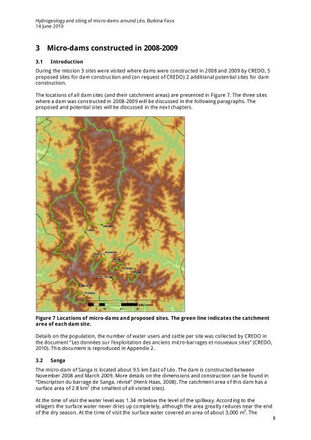
<strong>Hydrogeology</strong> <strong>and</strong> <strong>siting</strong> <strong>of</strong> <strong>micro</strong>-<strong>dams</strong> <strong>around</strong> <strong>Léo</strong>, <strong>Burkina</strong> <strong>Faso</strong>14 June 20103 Micro-<strong>dams</strong> constructed in 2008-20093.1 IntroductionDuring the mission 3 sites were visited where <strong>dams</strong> were constructed in 2008 <strong>and</strong> 2009 by CREDO, 5proposed sites for dam construction <strong>and</strong> (on request <strong>of</strong> CREDO) 2 additional potential sites for damconstruction.The locations <strong>of</strong> all dam sites (<strong>and</strong> their catchment areas) are presented in Figure 7. The three siteswhere a dam was constructed in 2008-2009 will be discussed in the following paragraphs. Theproposed <strong>and</strong> potential sites will be discussed in the next chapters.Figure 7 Locations <strong>of</strong> <strong>micro</strong>-<strong>dams</strong> <strong>and</strong> proposed sites. The green line indicates the catchmentarea <strong>of</strong> each dam site.Details on the population, the number <strong>of</strong> water users <strong>and</strong> cattle per site was collected by CREDO inthe document “Les données sur l’exploitation des anciens <strong>micro</strong>-barrages et nouveaux sites” (CREDO,2010). This document is reproduced in Appendix 2.3.2 SangaThe <strong>micro</strong>-dam <strong>of</strong> Sanga is located about 9.5 km East <strong>of</strong> <strong>Léo</strong>. The dam is constructed betweenNovember 2008 <strong>and</strong> March 2009. More details on the dimensions <strong>and</strong> construction can be found in“Description du barrage de Sanga, révisé” (Henk Haas, 2008). The catchment area <strong>of</strong> this dam has asurface area <strong>of</strong> 2.8 km 2 (the smallest <strong>of</strong> all visited sites).At the time <strong>of</strong> visit the water level was 1.34 m below the level <strong>of</strong> the spillway. According to thevillagers the surface water never dries up completely, although the area greatly reduces near the end<strong>of</strong> the dry season. At the time <strong>of</strong> visit the surface water covered an area <strong>of</strong> about 3,000 m 2 . The8