Hydrogeology and siting of micro-dams around Léo Burkina Faso
Hydrogeology and siting of micro-dams around Léo ... - SamSamWater
Hydrogeology and siting of micro-dams around Léo ... - SamSamWater

Create successful ePaper yourself
Turn your PDF publications into a flip-book with our unique Google optimized e-Paper software.
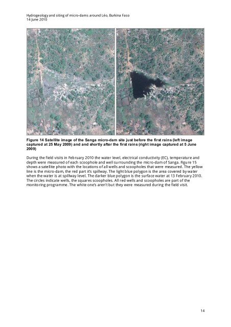
<strong>Hydrogeology</strong> <strong>and</strong> <strong>siting</strong> <strong>of</strong> <strong>micro</strong>-<strong>dams</strong> <strong>around</strong> <strong>Léo</strong>, <strong>Burkina</strong> <strong>Faso</strong>14 June 2010Figure 14 Satellite image <strong>of</strong> the Sanga <strong>micro</strong>-dam site just before the first rains (left imagecaptured at 25 May 2009) <strong>and</strong> <strong>and</strong> shortly after the first rains (right image captured at 5 June2009)During the field visits in February 2010 the water level, electrical conductivity (EC), temperature <strong>and</strong>depth were measured <strong>of</strong> each scoophole <strong>and</strong> well surrounding the <strong>micro</strong>-dam <strong>of</strong> Sanga. Figure 15shows a satellite photo with the locations <strong>of</strong> all wells <strong>and</strong> scoopholes that were measured. The yellowline is the <strong>micro</strong>-dam, the red part it’s spillway. The light blue polygon is the area covered by waterwhen the water is at spillway level. The darker blue polygon is the surface water at 13 February 2010.The circles indicate wells, the squares scoopholes. All red wells <strong>and</strong> scoopholes are part <strong>of</strong> themonitoring programme. The white one’s aren’t but they were measured during the field visit.14