Hydrogeology and siting of micro-dams around Léo Burkina Faso
Hydrogeology and siting of micro-dams around Léo ... - SamSamWater
Hydrogeology and siting of micro-dams around Léo ... - SamSamWater

Create successful ePaper yourself
Turn your PDF publications into a flip-book with our unique Google optimized e-Paper software.
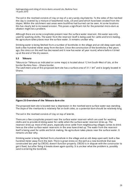
<strong>Hydrogeology</strong> <strong>and</strong> <strong>siting</strong> <strong>of</strong> <strong>micro</strong>-<strong>dams</strong> <strong>around</strong> <strong>Léo</strong>, <strong>Burkina</strong> <strong>Faso</strong>14 June 2010The soil in the riverbed consists <strong>of</strong> clay on top <strong>of</strong> a very s<strong>and</strong>y clay/laterite. To the sides <strong>of</strong> the riverbedthe clay is covered by a mixture <strong>of</strong> weathered rocks, silt <strong>and</strong> s<strong>and</strong> which have been eroded from theslopes. Within the catchment vast areas were bushfires had burned can be seen. At some locationsthis has clearly led to increased erosion. This poses a significant risk for the potential <strong>micro</strong>-dam assiltation might be a problem.Although there are some scoopholes present near the surface water reservoir, this water was onlyused for washing cloths. The water from the reservoir itself is being used for cattle <strong>and</strong> brick making.No agriculture takes places near the surface water. It remains unclear why.Drinking water is being fetched from a number <strong>of</strong> boreholes in the village <strong>and</strong> an old deep open well,both a few hundred meter away from the dam. Since the construction <strong>of</strong> the boreholes a few yearsago, the stress on this well has decreased <strong>and</strong> it now has water all year round, where before it driedup at the end <strong>of</strong> the dry season.5.5 TékouraTékoura (or Tiékoura as indicated on some maps) is located about 12 km South-West <strong>of</strong> <strong>Léo</strong>, at theborder <strong>Burkina</strong> <strong>Faso</strong> – Ghana border.The catchment area <strong>of</strong> this proposed dam site has a surface area <strong>of</strong> 31.1 km 2 <strong>and</strong> is largely located inGhana.Figure 25 Overview <strong>of</strong> the Tékoura dam siteThe proposed dam site is located near a depression in the riverbed were surface water was st<strong>and</strong>ing.The slope <strong>of</strong> the riverbanks is relatively flat on both sides, so a potential dam should be relatively long.The soil in the riverbed consists <strong>of</strong> clay on top <strong>of</strong> laterite.There are a few scoopholes present near the surface water reservoir which are used for washingcloths <strong>and</strong> to provide drinking water for cattle when the surface water reservoir dries up. Thereservoir dries up most <strong>of</strong> the years, especially since cattle from neighbouring villages comes to drinkhere as the other surface water reservoirs in the area have dried up. The water from the reservoiritself is being used for cattle <strong>and</strong> brick making. No agriculture takes places near the surface water. Itremains unclear why.Drinking water is being fetched from a borehole in the village <strong>and</strong> an old deep open well, both a fewhundred meter away from the dam. There is great stress on the well as a new borehole that wasconstructed last year by CREDO, doesn’t function properly. CREDO is in dispute with the constructor toget it fixed, but after fixing it breaks down again quickly. It is unclear what the problem is, possiblys<strong>and</strong> is entering the borehole.26