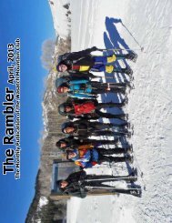
Rambler
Jan - Wasatch Mountain Club
Jan - Wasatch Mountain Club
- No tags were found...

You also want an ePaper? Increase the reach of your titles
YUMPU automatically turns print PDFs into web optimized ePapers that Google loves.
oads<br />
fork<br />
twin<br />
peaks<br />
Broads Fork Twin<br />
Peaks, more<br />
frequently referred<br />
to simply as “Twin<br />
Peaks”, is the<br />
highest and most<br />
prominent mountain<br />
on the eastern<br />
skyline behind Salt<br />
Lake Valley. With<br />
an elevation of<br />
11,330 feet (east<br />
summit) and 11,328<br />
feet (west summit),<br />
the Twins rise<br />
nearly 7,000 vertical<br />
feet above the<br />
valley floor.<br />
Traversing to the<br />
West Twin<br />
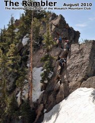
The most commonly used ascent route is via Broads Fork; a class 3 climb of 5,100+<br />
vertical feet with some scrambling and exposure. More difficult routes can be found<br />
in Broads Fork, as well as Deaf Smith Canyon, Ferguson Canyon, Tanners Gulch, Stairs<br />
Gulch and Lisa Falls. The center of the Twin Peaks Wilderness Area, the peaks here<br />
are some of the most rugged to be found in the Wasatch. Needless to say, the summit<br />
views of Salt Lake City and the surrounding Wasatch Mountains are excellent.<br />
The Broads Fork trailhead is four miles up the Big Cottonwood Canyon road (UT-190).<br />
Get there by either taking I-15 to I-215 east at about 60 th south, or take I-80 east to<br />
Wasatch Boulevard. The parking lot fills quickly in the summer months.<br />
Access to Deaf Smith is difficult and threatened by homeowners. The trail starts at the<br />
end of Golden Oaks Drive (just off Wasatch Boulevard) at a dirt road. Try to park in a<br />
manner that does not disturb the homeowners.<br />
Broads Fork Twin Peaks offers a variety of route options, ranging from relatively<br />
straightforward 3rd class scrambles, to exposed 4th class ridges and steep spring snow<br />
climbs. (From summitpost.org)<br />
31