geodesign-in-practice
- No tags were found...

Create successful ePaper yourself
Turn your PDF publications into a flip-book with our unique Google optimized e-Paper software.
assess<strong>in</strong>g the condition of a place and its people work<strong>in</strong>g across<br />
scales to determ<strong>in</strong>e how one region, neighborhood, or number of<br />
sites might affect another. S<strong>in</strong>ce it is holistic <strong>in</strong> nature, it requires<br />
gather<strong>in</strong>g diverse geographic data cover<strong>in</strong>g the natural, cultural,<br />
and built environments.<br />
To beg<strong>in</strong> the study, data <strong>in</strong>ventories had to be collected and/or<br />
created for each level of <strong>in</strong>vestigation to meet the <strong>in</strong>formational<br />
demands of each scale from the region to the neighborhood<br />
to the site. ArcGIS played a significant role by provid<strong>in</strong>g the<br />
data storage framework necessary to store, analyze, query,<br />
and visualize economic, environmental, and social data across<br />
multiple scales.<br />
• Identify disadvantaged neighborhoods, def<strong>in</strong>ed as census<br />
tracts with a median household <strong>in</strong>come that is 80 percent of<br />
the state median household <strong>in</strong>come.<br />
At the regional scale, these two criteria formed the basis of<br />
the <strong>geodesign</strong> evaluation models that would result <strong>in</strong> the<br />
identification of three neighborhoods most <strong>in</strong> need: L<strong>in</strong>coln<br />
Heights, Westlake, and Florence.<br />
Identify<strong>in</strong>g Neighborhoods<br />
To beg<strong>in</strong> the study for Los Angeles, researchers exam<strong>in</strong>ed the<br />
geographic context of the region to determ<strong>in</strong>e the highestneed<br />
neighborhoods that could most benefit by the improved<br />
environmental, social, and economic health result<strong>in</strong>g from<br />
convert<strong>in</strong>g distressed properties to open space.<br />
Two criteria were chosen, which were based on California<br />
Proposition 84 fund<strong>in</strong>g standards that have been <strong>in</strong>strumental <strong>in</strong><br />
provid<strong>in</strong>g fund<strong>in</strong>g for parks and nature facilities <strong>in</strong> California:<br />
• Identify the most park-poor areas, def<strong>in</strong>ed as hav<strong>in</strong>g three<br />
acres or less of parkland per 1,000 people based on census<br />
tract data.<br />
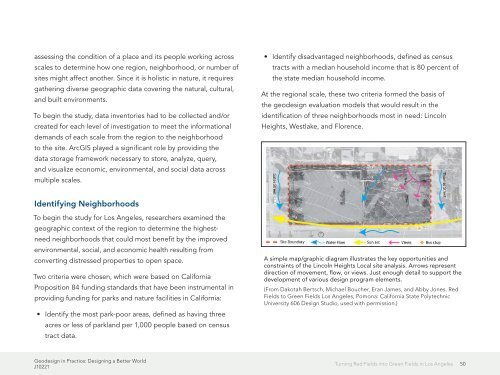
A simple map/graphic diagram illustrates the key opportunities and<br />
constra<strong>in</strong>ts of the L<strong>in</strong>coln Heights Local site analysis. Arrows represent<br />
direction of movement, flow, or views. Just enough detail to support the<br />
development of various design program elements.<br />
(From Dakotah Bertsch, Michael Boucher, Eran James, and Abby Jones. Red<br />
Fields to Green Fields Los Angeles, Pomona: California State Polytechnic<br />
University 606 Design Studio, used with permission.)<br />
Geodesign <strong>in</strong> Practice: Design<strong>in</strong>g a Better World<br />
J10221<br />
Turn<strong>in</strong>g Red Fields <strong>in</strong>to Green Fields <strong>in</strong> Los Angeles<br />
50