The Earth Scientist
Fall 12.pdf - NESTA
Fall 12.pdf - NESTA
- No tags were found...

You also want an ePaper? Increase the reach of your titles
YUMPU automatically turns print PDFs into web optimized ePapers that Google loves.
Page 20<br />
<strong>The</strong> <strong>Earth</strong> <strong>Scientist</strong><br />
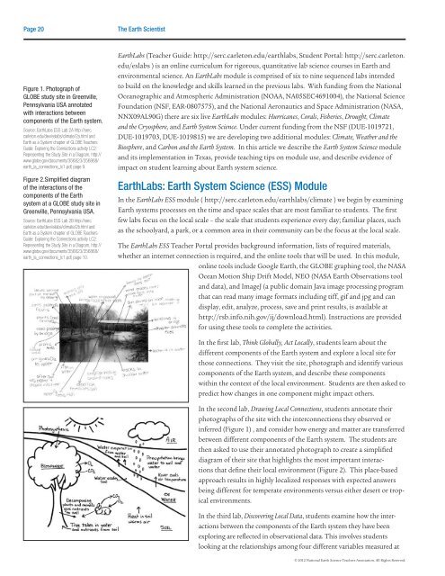
Figure 1. Photograph of<br />
GLOBE study site in Greenville,<br />
Pennsylvania USA annotated<br />
with interactions between<br />
components of the <strong>Earth</strong> system.<br />
Source: <strong>Earth</strong>Labs ESS Lab 2A http://serc.<br />
carleton.edu/dev/eslabs/climate/2a.html and<br />
<strong>Earth</strong> as a System chapter of GLOBE Teachers<br />
Guide: Exploring the Connections activity LC2:<br />
Representing the Study Site in a Diagram, http://<br />
www.globe.gov/documents/356823/356868/<br />
earth_la_connections_lc1.pdf, page 9.<br />
Figure 2.Simplified diagram<br />
of the interactions of the<br />
components of the <strong>Earth</strong><br />
system at a GLOBE study site in<br />
Greenville, Pennsylvania USA.<br />
Source: <strong>Earth</strong>Labs ESS Lab 2B http://serc.<br />
carleton.edu/dev/eslabs/climate/2b.html and<br />
<strong>Earth</strong> as a System chapter of GLOBE Teachers<br />
Guide: Exploring the Connections activity LC2:<br />
Representing the Study Site in a Diagram, http://<br />
www.globe.gov/documents/356823/356868/<br />
earth_la_connections_lc1.pdf, page 10.<br />
<strong>Earth</strong>Labs (Teacher Guide: http://serc.carleton.edu/earthlabs, Student Portal: http://serc.carleton.<br />
edu/eslabs ) is an online curriculum for rigorous, quantitative lab science courses in <strong>Earth</strong> and<br />
environmental science. An <strong>Earth</strong>Labs module is comprised of six to nine sequenced labs intended<br />
to build on the knowledge and skills learned in the previous labs. With funding from the National<br />
Oceanographic and Atmospheric Administration (NOAA, NA05SEC4691004), the National Science<br />
Foundation (NSF, EAR-0807575), and the National Aeronautics and Space Administration (NASA,<br />
NNX09AL90G) there are six live <strong>Earth</strong>Labs modules: Hurricanes, Corals, Fisheries, Drought, Climate<br />
and the Cryosphere, and <strong>Earth</strong> System Science. Under current funding from the NSF (DUE-1019721,<br />
DUE-1019703, DUE-1019815) we are developing two additional modules: Climate, Weather and the<br />
Biosphere, and Carbon and the <strong>Earth</strong> System. In this article we describe the <strong>Earth</strong> System Science module<br />
and its implementation in Texas, provide teaching tips on module use, and describe evidence of<br />
impact on student learning about <strong>Earth</strong> system science.<br />
<strong>Earth</strong>Labs: <strong>Earth</strong> System Science (ESS) Module<br />
In the <strong>Earth</strong>Labs ESS module ( http://serc.carleton.edu/earthlabs/climate ) we begin by examining<br />
<strong>Earth</strong> systems processes on the time and space scales that are most familiar to students. <strong>The</strong> first<br />
few labs focus on the local scale – the scale that students experience every day; familiar places, such<br />
as the schoolyard, a park, or a common area in their community can be the focus at the local scale.<br />
<strong>The</strong> <strong>Earth</strong>Labs ESS Teacher Portal provides background information, lists of required materials,<br />
whether an internet connection is required, and the online tools that will be used. In this module,<br />
online tools include Google <strong>Earth</strong>, the GLOBE graphing tool, the NASA<br />
Ocean Motion Ship Drift Model, NEO (NASA <strong>Earth</strong> Observations tool<br />
and data), and ImageJ (a public domain Java image processing program<br />
that can read many image formats including tiff, gif and jpg and can<br />
display, edit, analyze, process, save and print results, is available at<br />
http://rsb.info.nih.gov/ij/download.html). Instructions are provided<br />
for using these tools to complete the activities.<br />
In the first lab, Think Globally, Act Locally, students learn about the<br />
different components of the <strong>Earth</strong> system and explore a local site for<br />
those connections. <strong>The</strong>y visit the site, photograph and identify various<br />
components of the <strong>Earth</strong> system, and describe these components<br />
within the context of the local environment. Students are then asked to<br />
predict how changes in one component might impact others.<br />
In the second lab, Drawing Local Connections, students annotate their<br />
photographs of the site with the interconnections they observed or<br />
inferred (Figure 1) , and consider how energy and matter are transferred<br />
between different components of the <strong>Earth</strong> system. <strong>The</strong> students are<br />
then asked to use their annotated photograph to create a simplified<br />
diagram of their site that highlights the most important interactions<br />
that define their local environment (Figure 2). This place-based<br />
approach results in highly localized responses with expected answers<br />
being different for temperate environments versus either desert or tropical<br />
environments.<br />
In the third lab, Discovering Local Data, students examine how the interactions<br />
between the components of the <strong>Earth</strong> system they have been<br />
exploring are reflected in observational data. This involves students<br />
looking at the relationships among four different variables measured at<br />
© 2012 National <strong>Earth</strong> Science Teachers Association. All Rights Reserved.